
Texas Spring 2019
Moderator: S2k Moderators
Forum rules

The posts in this forum are NOT official forecast and should not be used as such. They are just the opinion of the poster and may or may not be backed by sound meteorological data. They are NOT endorsed by any professional institution or STORM2K.
-
bubba hotep

- S2K Supporter

- Posts: 6014
- Joined: Wed Dec 28, 2016 1:00 am
- Location: Collin County Texas
Re: Texas Spring 2019
Reportedly from that same cell
4 likes
Winter time post are almost exclusively focused on the DFW area.
-
bubba hotep
- S2K Supporter
- Posts: 6014
- Joined: Wed Dec 28, 2016 1:00 am
- Location: Collin County Texas
Re: Texas Spring 2019
This thing is beasting!

4 likes
Winter time post are almost exclusively focused on the DFW area.

Re: Texas Spring 2019
Storm clustering in far west Texas tells me (with timing) MCS by mid morning for I-35 corridor.
0 likes
The above post and any post by Ntxw is NOT an official forecast and should not be used as such. It is just the opinion of the poster and may or may not be backed by sound meteorological data. It is NOT endorsed by any professional institution including Storm2k. For official information, please refer to NWS products.
Help support Storm2K!
-
Haris

- Category 5

- Posts: 1814
- Joined: Mon Nov 27, 2017 8:19 pm
- Location: ( Bee Cave) West Austin, Texas
Re: Texas Spring 2019
Ntxw wrote:Storm clustering in far west Texas tells me (with timing) MCS by mid morning for I-35 corridor.
I know it's tricky but do you think we see the mcs impact the AUS area?
0 likes
Weather geek and a storm spotter in West Austin. Not a degreed meteorologist. Big snow fan. Love rain and cold! Despise heat!
Re: Texas Spring 2019
Haris wrote:Ntxw wrote:Storm clustering in far west Texas tells me (with timing) MCS by mid morning for I-35 corridor.
I know it's tricky but do you think we see the mcs impact the AUS area?
It may miss to the north given sw/ne (but east for the line) storm motion. But like you said can be tricky with outflows.
0 likes
The above post and any post by Ntxw is NOT an official forecast and should not be used as such. It is just the opinion of the poster and may or may not be backed by sound meteorological data. It is NOT endorsed by any professional institution including Storm2k. For official information, please refer to NWS products.
Help support Storm2K!
Help support Storm2K!
-
bubba hotep
- S2K Supporter
- Posts: 6014
- Joined: Wed Dec 28, 2016 1:00 am
- Location: Collin County Texas
Re: Texas Spring 2019
West Texas convection has mostly fallen apart. Based on Hi-Res ensemble runs from today, that should allow for a MCS to form farther north later tonight. Might also mean a later arrival at DFW increasing svr wx threat.
0 likes
Winter time post are almost exclusively focused on the DFW area.
-
Brent
- S2K Supporter
- Posts: 38755
- Age: 37
- Joined: Sun May 16, 2004 10:30 pm
- Location: Tulsa Oklahoma
- Contact:
Re: Texas Spring 2019
SPC Day 1 very similar, the enhanced begins right around Dallas. Highest probs remain east of the metro
the HRRR has the initial line mostly missing the entire metro to the north
and definitely has a threatening look early to mid afternoon for the metro with broken cells

the HRRR has the initial line mostly missing the entire metro to the north
and definitely has a threatening look early to mid afternoon for the metro with broken cells
0 likes
#neversummer
-
TheProfessor

- Professional-Met

- Posts: 3506
- Age: 29
- Joined: Tue Dec 03, 2013 10:56 am
- Location: Wichita, Kansas
Re: Texas Spring 2019
Ok, so two things I'm seeing with the 5z HRRR, some of which will likely keep today an enhanced risk.
1. There's a lot of Veer-back-veer profiles in Texas and Arkansas, especially early in the day. However, some of the VBV profiles I saw are higher up in the atmosphere, above the 0-3 km. There are some hypothesis that VBV won't hinder the development of supercells if it's high enough above the surface. I'd say that everyone should stay on guard during the morning and early afternoon.
2. Things start to get iffy after the first round of storms move through on the HRRR. The HRRR develops a second line of storms in Jack and Wise counties. If the 5z HRRR is correct then I believe the enhanced risk may need to be expanded westward. The HRRR show basically no VBV after the first storms pass through, suitable to even fairly high CAPE left, and pretty intense shear and turning in the atmosphere. My only thing that makes me hesitant is how much energy will that first line of storms take up, and will there be enough time for re-destabilization for the 2nd round of storms to tap in to. If the HRRR is correct with it's CAPE value after the first storms pass through, then everyone in the metroplex needs to be on high guard between 1-5PM.
Unfortunately I'm traveling today, so I won't be able to keep up to see if the HRRR continues to trend to a 2nd line of storms developing, though I'll definitely be peaking during my layovers. I hope everyone stays safe today.
1. There's a lot of Veer-back-veer profiles in Texas and Arkansas, especially early in the day. However, some of the VBV profiles I saw are higher up in the atmosphere, above the 0-3 km. There are some hypothesis that VBV won't hinder the development of supercells if it's high enough above the surface. I'd say that everyone should stay on guard during the morning and early afternoon.
2. Things start to get iffy after the first round of storms move through on the HRRR. The HRRR develops a second line of storms in Jack and Wise counties. If the 5z HRRR is correct then I believe the enhanced risk may need to be expanded westward. The HRRR show basically no VBV after the first storms pass through, suitable to even fairly high CAPE left, and pretty intense shear and turning in the atmosphere. My only thing that makes me hesitant is how much energy will that first line of storms take up, and will there be enough time for re-destabilization for the 2nd round of storms to tap in to. If the HRRR is correct with it's CAPE value after the first storms pass through, then everyone in the metroplex needs to be on high guard between 1-5PM.
Unfortunately I'm traveling today, so I won't be able to keep up to see if the HRRR continues to trend to a 2nd line of storms developing, though I'll definitely be peaking during my layovers.
3 likes
An alumnus of The Ohio State University.
Your local National Weather Service office is your best source for weather information.
Your local National Weather Service office is your best source for weather information.
-
Brent
- S2K Supporter
- Posts: 38755
- Age: 37
- Joined: Sun May 16, 2004 10:30 pm
- Location: Tulsa Oklahoma
- Contact:
Re: Texas Spring 2019
TheProfessor wrote:Ok, so two things I'm seeing with the 5z HRRR, some of which will likely keep today an enhanced risk.
1. There's a lot of Veer-back-veer profiles in Texas and Arkansas, especially early in the day. However, some of the VBV profiles I saw are higher up in the atmosphere, above the 0-3 km. There are some hypothesis that VBV won't hinder the development of supercells if it's high enough above the surface. I'd say that everyone should stay on guard during the morning and early afternoon.
2. Things start to get iffy after the first round of storms move through on the HRRR. The HRRR develops a second line of storms in Jack and Wise counties. If the 5z HRRR is correct then I believe the enhanced risk may need to be expanded westward. The HRRR show basically no VBV after the first storms pass through, suitable to even fairly high CAPE left, and pretty intense shear and turning in the atmosphere. My only thing that makes me hesitant is how much energy will that first line of storms take up, and will there be enough time for re-destabilization for the 2nd round of storms to tap in to. If the HRRR is correct with it's CAPE value after the first storms pass through, then everyone in the metroplex needs to be on high guard between 1-5PM.
Unfortunately I'm traveling today, so I won't be able to keep up to see if the HRRR continues to trend to a 2nd line of storms developing, though I'll definitely be peaking during my layovers.
yeah its very complicated today,,,, I'm still not sure exactly what to expect. Still could be just one line and done, but the slower trend is definitely disturbing
Unfortunately I'll be working for most of it it seems
1 likes
#neversummer
-
Texas Snowman

- Storm2k Moderator

- Posts: 6197
- Joined: Fri Jan 25, 2008 11:29 am
- Location: Denison, Texas
Re: Texas Spring 2019
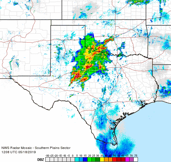
Tornado may be in progress right now across portions of San Angelo. Very significant radar presentation for some time as it approached the city.
1 likes
The above post and any post by Texas Snowman is NOT an official forecast and should not be used as such. It is just the opinion of the poster and may or may not be backed by sound meteorological data. It is NOT endorsed by any professional institution including storm2k.org. For official information, please refer to NWS products.
-
rwfromkansas
- Category 5
- Posts: 3038
- Joined: Sat Aug 27, 2005 12:47 am
- Location: North Fort Worth
Re: Texas Spring 2019
Lots of damage reports around San Angelo, including collapsed buildings.
Also Abilene damage.
These storms are unusually strong for this early.
They also are not in a line.
All models got that wrong apparently.
Also Abilene damage.
These storms are unusually strong for this early.
They also are not in a line.
All models got that wrong apparently.
0 likes
-
Texas Snowman
- Storm2k Moderator
- Posts: 6197
- Joined: Fri Jan 25, 2008 11:29 am
- Location: Denison, Texas
Re: Texas Spring 2019
758
WFUS54 KSJT 181219
TORSJT
TXC399-181300-
/O.NEW.KSJT.TO.W.0037.190518T1219Z-190518T1300Z/
BULLETIN - EAS ACTIVATION REQUESTED
Tornado Warning
National Weather Service San Angelo TX
719 AM CDT Sat May 18 2019
The National Weather Service in San Angelo has issued a
* Tornado Warning for...
Southeastern Runnels County in west central Texas...
* Until 800 AM CDT.
* At 719 AM CDT, a confirmed large and extremely dangerous tornado
was located near Ballinger, moving north at 30 mph.
This is a PARTICULARLY DANGEROUS SITUATION. TAKE COVER NOW!
HAZARD...Damaging tornado.
SOURCE...Weather spotters confirmed tornado.
IMPACT...You are in a life-threatening situation. Flying debris
may be deadly to those caught without shelter. Mobile
homes will be destroyed. Considerable damage to homes,
businesses, and vehicles is likely and complete
destruction is possible.
* The tornado will be near...
Ballinger around 730 AM CDT.
Benoit around 735 AM CDT.
Hatchel around 740 AM CDT.
Other locations impacted by this tornadic thunderstorm include
Ballinger Lake.
PRECAUTIONARY/PREPAREDNESS ACTIONS...
To repeat, a large, extremely dangerous and potentially deadly
tornado is on the ground. To protect your life, TAKE COVER NOW! Move
to a basement or an interior room on the lowest floor of a sturdy
building. Avoid windows. If you are outdoors, in a mobile home, or in
a vehicle, move to the closest substantial shelter and protect
yourself from flying debris.
&&
LAT...LON 3179 9972 3162 9997 3168 10006 3189 10002
TIME...MOT...LOC 1219Z 201DEG 27KT 3170 9999
TORNADO...OBSERVED
TORNADO DAMAGE THREAT...CONSIDERABLE
HAIL...1.00IN
$$
0 likes
The above post and any post by Texas Snowman is NOT an official forecast and should not be used as such. It is just the opinion of the poster and may or may not be backed by sound meteorological data. It is NOT endorsed by any professional institution including storm2k.org. For official information, please refer to NWS products.
-
cheezyWXguy

- Category 5
- Posts: 6282
- Joined: Mon Feb 13, 2006 12:29 am
- Location: Dallas, TX
Re: Texas Spring 2019
Professor, you called it. The spc has made a major expansion westward to include all of dfw, and even out to Abilene, in the the enhanced risk and sig 10% tornado probabilities. It seems they’ve given up the idea of the mcs working over the atmosphere, and are following the hrrr
0 likes
-
WacoWx
- Category 2

- Posts: 692
- Joined: Mon Dec 28, 2009 4:14 pm
- Location: NOT Waco, TX ----> Dallas, TX
Re: Texas Spring 2019
Are these elevated showers ongoing in dfw going to take any juice outta the atmosphere, leaving us a little more stable by the time the main energy arrives by noon’ish?
0 likes
-
cheezyWXguy
- Category 5
- Posts: 6282
- Joined: Mon Feb 13, 2006 12:29 am
- Location: Dallas, TX
Re: Texas Spring 2019
WacoWx wrote:Are these elevated showers ongoing in dfw going to take any juice outta the atmosphere, leaving us a little more stable by the time the main energy arrives by noon’ish?
I doubt it. The nam and hrrr were showing the atmosphere recovering to 3000-4000j/kg this afternoon, even back when they had the mcs moving through dfw in the morning. With only these streamer showers now, the warm sector should remain virtually untapped until the afternoon.
0 likes

Re: Texas Spring 2019
Any thoughts on what’s going to happen this afternoon for DFW?
Is the line out west going to move through or will there be more discreet cells out in front? Thought that a line was originally supposed to move through this morning, or am I missing something?
Is the line out west going to move through or will there be more discreet cells out in front? Thought that a line was originally supposed to move through this morning, or am I missing something?
0 likes
-
rwfromkansas
- Category 5
- Posts: 3038
- Joined: Sat Aug 27, 2005 12:47 am
- Location: North Fort Worth
Re: Texas Spring 2019
Storms are lining up now with movement now more east. Likely would kill afternoon severe weather, right?
0 likes
-
cheezyWXguy
- Category 5
- Posts: 6282
- Joined: Mon Feb 13, 2006 12:29 am
- Location: Dallas, TX
Re: Texas Spring 2019
newtotex wrote:Any thoughts on what’s going to happen this afternoon for DFW?
Is the line out west going to move through or will there be more discreet cells out in front? Thought that a line was originally supposed to move through this morning, or am I missing something?
There was, and it was supposed to work over the atmosphere so the afternoon storms wouldn’t have enough fuel to get strong. However, the line hasn’t played out the way the models showed, and severe probabilities have been increased for this afternoon
0 likes
Re: Texas Spring 2019
Earlier this morning when the new storms initiated and fragmented dropped a couple of tornadoes. It's become more organized now and still looking like a midday passage. If anything forms ahead away from the congeal is the best shot for super-cellular mode. There's one lone one (earlier Ballinger cell) but will be fought with more organized activity catching up.
0 likes
The above post and any post by Ntxw is NOT an official forecast and should not be used as such. It is just the opinion of the poster and may or may not be backed by sound meteorological data. It is NOT endorsed by any professional institution including Storm2k. For official information, please refer to NWS products.
Help support Storm2K!
Help support Storm2K!
Return to “USA & Caribbean Weather”
Who is online
Users browsing this forum: No registered users and 90 guests