ATL: MICHAEL - Models

Moderator: S2k Moderators

Message
Author
User avatar
robbielyn
Category 5
Category 5
Posts: 1298
Joined: Wed May 07, 2003 9:45 am
Location: brooksville, fl

Re: ATL: FOURTEEN - Models

#281 Postby robbielyn » Sun Oct 07, 2018 12:42 pm

chaser1 wrote:Panama City to St. Marks was where I was suggesting landfall 2 day's ago and beginning to think those point need be nudged to Carrabelle to Steinhatchee instead. I'm gonna guess recon will provide enough data to support an upgrade to "Michael" by early evening, but will confirm a broad ENE to WSW tilted orientation. I'm also guessing that with an eventual eastward reformation to occur by late tonight/early tomorrow, the EURO will shift at least a little to the east by tonight's 0Z run, with most/all other models following suit by their respective 6Z-12Z runs tomm. a.m. I'm a little concerned that following an acceleration towards the north (and then NNE), that some chance of ridging will build in along the mid Atlantic seaboard thus causing a possible decrease in the storm's forward speed as it approaches landfall. Aside from the obvious exacerbation of storm surge impact this could act as catalyst for some additional hours for further strengthening as well.

uh it's already Michael?!
0 likes   
Robbielyn McCrary
I know just about enough to sound like I know what I'm talking about sometimes. But for your safety please follow the nhc for truly professional forecasting. :D

LarryWx
S2K Supporter
S2K Supporter
Posts: 6305
Joined: Sun Sep 07, 2003 2:04 pm
Location: GA

Re: ATL: MICHAEL - Models

#282 Postby LarryWx » Sun Oct 07, 2018 12:43 pm

The 12Z GEFS mean is actually about 40 miles west of the 6Z GEFS mean at landfall in the panhandle.
0 likes   
Personal Forecast Disclaimer:
The posts in this forum are NOT official forecasts and should not be used as such. They are just the opinion of the poster and may or may not be backed by sound meteorological data. They are NOT endorsed by any professional institution or storm2k.org. For official information, please refer to the NHC and NWS products.

User avatar
p1nheadlarry
Category 2
Category 2
Posts: 672
Age: 33
Joined: Wed Jan 29, 2014 2:42 pm
Location: SR County FL

Re: ATL: FOURTEEN - Models

#283 Postby p1nheadlarry » Sun Oct 07, 2018 12:44 pm

hurricaneCW wrote:Don't like how the models are intensifying this thing up till landfall.

NHC is playing things very cautiously here, perhaps too cautiously as models show much more rapid intensification.


Yea and they ramped up Florence to a Cat 4 to hit a place that rarely sees them.
0 likes   
--;->#GoNoles--;->.

User avatar
chaser1
S2K Supporter
S2K Supporter
Posts: 5464
Age: 64
Joined: Sat Oct 15, 2005 5:59 pm
Location: Longwood, Fl

Re: ATL: MICHAEL - Models

#284 Postby chaser1 » Sun Oct 07, 2018 12:45 pm

Stepping back for just a moment, it's key to remember we don't have a fairly defined COC. Whether that occur a bit to the west or more to the east, I have to think this will resolve itself between this evening and tomm. morning. I'm pretty sure that most if not all models will suddenly cluster around a very tight consensus at this point especially in light of the relative small time frame we're all looking at between upgrade and final landfall. (As a side-note, the S2K website now seems to be operating normally - at least from my perspective).
0 likes   
Andy D

(For official information, please refer to the NHC and NWS products.)

Aric Dunn
Category 5
Category 5
Posts: 21238
Age: 42
Joined: Sun Sep 19, 2004 9:58 pm
Location: Ready for the Chase.
Contact:

Re: ATL: FOURTEEN - Models

#285 Postby Aric Dunn » Sun Oct 07, 2018 12:45 pm

robbielyn wrote:
chaser1 wrote:Panama City to St. Marks was where I was suggesting landfall 2 day's ago and beginning to think those point need be nudged to Carrabelle to Steinhatchee instead. I'm gonna guess recon will provide enough data to support an upgrade to "Michael" by early evening, but will confirm a broad ENE to WSW tilted orientation. I'm also guessing that with an eventual eastward reformation to occur by late tonight/early tomorrow, the EURO will shift at least a little to the east by tonight's 0Z run, with most/all other models following suit by their respective 6Z-12Z runs tomm. a.m. I'm a little concerned that following an acceleration towards the north (and then NNE), that some chance of ridging will build in along the mid Atlantic seaboard thus causing a possible decrease in the storm's forward speed as it approaches landfall. Aside from the obvious exacerbation of storm surge impact this could act as catalyst for some additional hours for further strengthening as well.

uh it's already Michael?!


Yeah it is already MIchael and there are two vorts rotating around still. the eastern one will take over shortly.
0 likes   
Note: If I make a post that is brief. Please refer back to previous posts for the analysis or reasoning. I do not re-write/qoute what my initial post said each time.
If there is nothing before... then just ask :)

Space & Atmospheric Physicist, Embry-Riddle Aeronautical University,
I believe the sky is falling...

User avatar
chaser1
S2K Supporter
S2K Supporter
Posts: 5464
Age: 64
Joined: Sat Oct 15, 2005 5:59 pm
Location: Longwood, Fl

Re: ATL: FOURTEEN - Models

#286 Postby chaser1 » Sun Oct 07, 2018 12:49 pm

robbielyn wrote:
chaser1 wrote:Panama City to St. Marks was where I was suggesting landfall 2 day's ago and beginning to think those point need be nudged to Carrabelle to Steinhatchee instead. I'm gonna guess recon will provide enough data to support an upgrade to "Michael" by early evening, but will confirm a broad ENE to WSW tilted orientation. I'm also guessing that with an eventual eastward reformation to occur by late tonight/early tomorrow, the EURO will shift at least a little to the east by tonight's 0Z run, with most/all other models following suit by their respective 6Z-12Z runs tomm. a.m. I'm a little concerned that following an acceleration towards the north (and then NNE), that some chance of ridging will build in along the mid Atlantic seaboard thus causing a possible decrease in the storm's forward speed as it approaches landfall. Aside from the obvious exacerbation of storm surge impact this could act as catalyst for some additional hours for further strengthening as well.

uh it's already Michael?!


LOL? I obviously missed something between the 10:00 a.m. discussion and now? I now see the 1:00 pm intermediate that NHC put out.... yet I don't see any special statement announcing the upgrade??? I'm confused.
0 likes   
Andy D

(For official information, please refer to the NHC and NWS products.)

User avatar
gatorcane
S2K Supporter
S2K Supporter
Posts: 23691
Age: 47
Joined: Sun Mar 13, 2005 3:54 pm
Location: Boca Raton, FL

Re: ATL: MICHAEL - Models

#287 Postby gatorcane » Sun Oct 07, 2018 12:50 pm

12Z Euro initializes with competing vorts:

Image
0 likes   

Aric Dunn
Category 5
Category 5
Posts: 21238
Age: 42
Joined: Sun Sep 19, 2004 9:58 pm
Location: Ready for the Chase.
Contact:

Re: ATL: MICHAEL - Models

#288 Postby Aric Dunn » Sun Oct 07, 2018 12:52 pm

gatorcane wrote:12Z Euro initializes with competing vorts:

https://i.postimg.cc/9X6gmktr/ecmwf_uv850_vort_watl_1.png


well yeah... :)
0 likes   
Note: If I make a post that is brief. Please refer back to previous posts for the analysis or reasoning. I do not re-write/qoute what my initial post said each time.
If there is nothing before... then just ask :)

Space & Atmospheric Physicist, Embry-Riddle Aeronautical University,
I believe the sky is falling...

Aric Dunn
Category 5
Category 5
Posts: 21238
Age: 42
Joined: Sun Sep 19, 2004 9:58 pm
Location: Ready for the Chase.
Contact:

Re: ATL: FOURTEEN - Models

#289 Postby Aric Dunn » Sun Oct 07, 2018 12:52 pm

chaser1 wrote:
robbielyn wrote:
chaser1 wrote:Panama City to St. Marks was where I was suggesting landfall 2 day's ago and beginning to think those point need be nudged to Carrabelle to Steinhatchee instead. I'm gonna guess recon will provide enough data to support an upgrade to "Michael" by early evening, but will confirm a broad ENE to WSW tilted orientation. I'm also guessing that with an eventual eastward reformation to occur by late tonight/early tomorrow, the EURO will shift at least a little to the east by tonight's 0Z run, with most/all other models following suit by their respective 6Z-12Z runs tomm. a.m. I'm a little concerned that following an acceleration towards the north (and then NNE), that some chance of ridging will build in along the mid Atlantic seaboard thus causing a possible decrease in the storm's forward speed as it approaches landfall. Aside from the obvious exacerbation of storm surge impact this could act as catalyst for some additional hours for further strengthening as well.

uh it's already Michael?!


LOL? I obviously missed something between the 10:00 a.m. discussion and now? I now see the 1:00 pm intermediate that NHC put out.... yet I don't see any special statement announcing the upgrade??? I'm confused.


it was upgraded at the 11am advisory :P
0 likes   
Note: If I make a post that is brief. Please refer back to previous posts for the analysis or reasoning. I do not re-write/qoute what my initial post said each time.
If there is nothing before... then just ask :)

Space & Atmospheric Physicist, Embry-Riddle Aeronautical University,
I believe the sky is falling...

LarryWx
S2K Supporter
S2K Supporter
Posts: 6305
Joined: Sun Sep 07, 2003 2:04 pm
Location: GA

Re: ATL: MICHAEL - Models

#290 Postby LarryWx » Sun Oct 07, 2018 1:02 pm

12Z Euro is slower/SSE of its 0Z run. Odds pretty high it will be slower & E of its 0Z run. Also, it’s slightly stronger than its 0Z run.
0 likes   
Personal Forecast Disclaimer:
The posts in this forum are NOT official forecasts and should not be used as such. They are just the opinion of the poster and may or may not be backed by sound meteorological data. They are NOT endorsed by any professional institution or storm2k.org. For official information, please refer to the NHC and NWS products.

KUEFC
Tropical Storm
Tropical Storm
Posts: 137
Joined: Thu Sep 11, 2008 6:19 am

Re: ATL: MICHAEL - Models

#291 Postby KUEFC » Sun Oct 07, 2018 1:04 pm

LarryWx wrote:12Z Euro is slower/SSE of its 0Z run. Odds pretty high it will be slower & E of its 0Z run. Also, it’s slightly stronger than its 0Z run.

Doesn’t appear to be MUCH different though?
0 likes   

storm4u
Category 2
Category 2
Posts: 651
Joined: Wed Aug 11, 2004 7:26 am
Location: agawam, ma
Contact:

Re: ATL: MICHAEL - Models

#292 Postby storm4u » Sun Oct 07, 2018 1:04 pm

Euro is slower than every other model.. think we know in the next day or so which is right
0 likes   

User avatar
Hammy
Category 5
Category 5
Posts: 5849
Age: 41
Joined: Fri May 25, 2012 5:25 pm
Contact:

Re: ATL: FOURTEEN - Models

#293 Postby Hammy » Sun Oct 07, 2018 1:07 pm

hurricaneCW wrote:Don't like how the models are intensifying this thing up till landfall.

NHC is playing things very cautiously here, perhaps too cautiously as models show much more rapid intensification.


I'm hoping they go at least to Cat 2 on the next advisory (the one most people tune into because it comes out around the evening news time) so people start getting the idea that this may not just be an in-and-out 'weak hurricane'
0 likes   
The above post is not official and should not be used as such. It is the opinion of the poster and may or may not be backed by sound meteorological data. It is not endorsed by any professional institution or storm2k.org. For official information, please refer to the NHC and NWS products.

User avatar
robbielyn
Category 5
Category 5
Posts: 1298
Joined: Wed May 07, 2003 9:45 am
Location: brooksville, fl

Re: ATL: FOURTEEN - Models

#294 Postby robbielyn » Sun Oct 07, 2018 1:07 pm

Aric Dunn wrote:
robbielyn wrote:
chaser1 wrote:Panama City to St. Marks was where I was suggesting landfall 2 day's ago and beginning to think those point need be nudged to Carrabelle to Steinhatchee instead. I'm gonna guess recon will provide enough data to support an upgrade to "Michael" by early evening, but will confirm a broad ENE to WSW tilted orientation. I'm also guessing that with an eventual eastward reformation to occur by late tonight/early tomorrow, the EURO will shift at least a little to the east by tonight's 0Z run, with most/all other models following suit by their respective 6Z-12Z runs tomm. a.m. I'm a little concerned that following an acceleration towards the north (and then NNE), that some chance of ridging will build in along the mid Atlantic seaboard thus causing a possible decrease in the storm's forward speed as it approaches landfall. Aside from the obvious exacerbation of storm surge impact this could act as catalyst for some additional hours for further strengthening as well.

uh it's already Michael?!
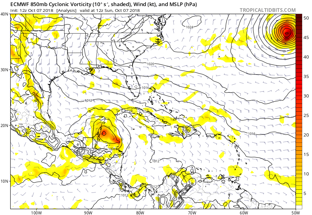

Yeah it is already MIchael and there are two vorts rotating around still. the eastern one will take over shortly.

that's where ukmet initialized from the Eastern vort.
Last edited by robbielyn on Sun Oct 07, 2018 1:08 pm, edited 1 time in total.
0 likes   
Robbielyn McCrary
I know just about enough to sound like I know what I'm talking about sometimes. But for your safety please follow the nhc for truly professional forecasting. :D

User avatar
PTrackerLA
Category 5
Category 5
Posts: 5277
Age: 41
Joined: Thu Oct 10, 2002 8:40 pm
Location: Lafayette, LA

Re: ATL: MICHAEL - Models

#295 Postby PTrackerLA » Sun Oct 07, 2018 1:08 pm

Yikes, 12z Euro 963mb at 72 hours...
1 likes   

LarryWx
S2K Supporter
S2K Supporter
Posts: 6305
Joined: Sun Sep 07, 2003 2:04 pm
Location: GA

Re: ATL: MICHAEL - Models

#296 Postby LarryWx » Sun Oct 07, 2018 1:08 pm

12Z Euro Hour 72: definitely coming in slower and will hit FL a good bit further east than its 0Z run.
0 likes   
Personal Forecast Disclaimer:
The posts in this forum are NOT official forecasts and should not be used as such. They are just the opinion of the poster and may or may not be backed by sound meteorological data. They are NOT endorsed by any professional institution or storm2k.org. For official information, please refer to the NHC and NWS products.

User avatar
NDG
S2K Supporter
S2K Supporter
Posts: 15446
Joined: Sun Jul 09, 2006 10:14 pm
Location: Orlando, FL

Re: ATL: MICHAEL - Models

#297 Postby NDG » Sun Oct 07, 2018 1:09 pm

So far the 12z Euro is throwing a monkey wrench at us, it might end up like the UKMET's track?
0 likes   

PSUHiker31
Tropical Storm
Tropical Storm
Posts: 114
Joined: Tue Oct 03, 2017 2:36 pm

Re: ATL: MICHAEL - Models

#298 Postby PSUHiker31 » Sun Oct 07, 2018 1:11 pm

It looks like the 12Z Euro chose the western vort to be more dominant. If that's the case, it's already looking wrong
0 likes   

User avatar
boca
Category 5
Category 5
Posts: 6367
Age: 60
Joined: Mon Dec 15, 2003 8:49 am
Location: Boca Raton,FL

Re: ATL: MICHAEL - Models

#299 Postby boca » Sun Oct 07, 2018 1:12 pm

Can someone posted a graphic of the UKMET plz
0 likes   

User avatar
gatorcane
S2K Supporter
S2K Supporter
Posts: 23691
Age: 47
Joined: Sun Mar 13, 2005 3:54 pm
Location: Boca Raton, FL

Re: ATL: MICHAEL - Models

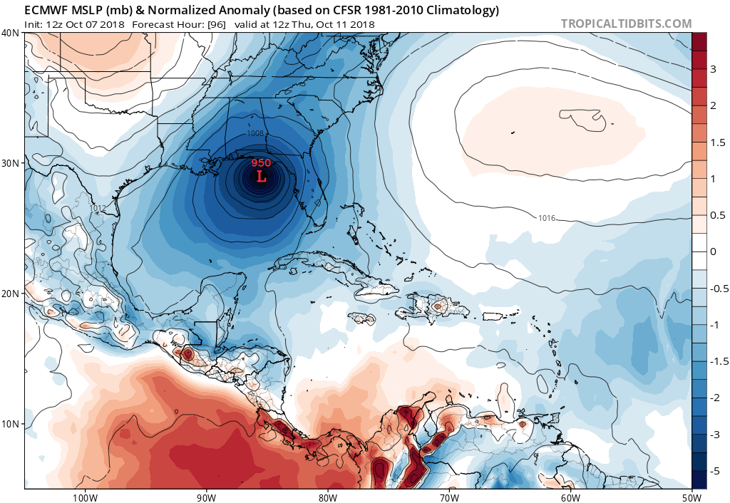
#300 Postby gatorcane » Sun Oct 07, 2018 1:15 pm

NDG wrote:So far the 12z Euro is throwing a monkey wrench at us, it might end up like the UKMET's track?


Euro shifts east towards UKMET....

Image
0 likes   


Return to “2018”

Who is online

Users browsing this forum: No registered users and 2 guests