ATL: ISAAC - Models
Moderator: S2k Moderators

Re: ATL: ISAAC - Models
Could be chaser. Certainly this isn't an optimal season. However, if we do get another pulse - even if it only brings in one new storm plus Isaac, you still have to figure that we'll see another 2-3 named storms in October somewhere in the Atlantic. It would probably put us slightly ahead of an average season. As of now, I think we're at 10-5-1. Average season is like 12/6/3 or close to that. ACE is currently at 64.1 and we should get at least another 8-15 points over the next couple of days. So we're getting very close to average there as well. 67-110 (or so) is considered average, so we're almost certainly going to fall somewhere within that range by the end of the season.
1 likes

Re: ATL: ISAAC - Models
12Z GFS poofs Isaac in the Western Caribbean and you can see the open wave heading toward the Yuacatan. Not a fan of that NW movement though.
2 likes
Personal Forecast Disclaimer:
The posts in this forum are NOT official forecast and should not be used as such. They are just the opinion of the poster and may or may not be backed by sound meteorological data. They are NOT endorsed by any professional institution or storm2k.org. For official information, please refer to the NHC and NWS products.
The posts in this forum are NOT official forecast and should not be used as such. They are just the opinion of the poster and may or may not be backed by sound meteorological data. They are NOT endorsed by any professional institution or storm2k.org. For official information, please refer to the NHC and NWS products.

Re: ATL: ISAAC - Models
SoupBone wrote:blp wrote:I have been looking at the shear forecast past few days for the GFS and FV3 and I keep seeing a good environment once it gets to the W. Caribbean yet they keep opening it up. Maybe I am reading it wrong.
Model performance has been poor in my opinion on this. Most had Issac remaining strong up to the islands and it has been badly sheered and barely hanging on so those forecasts bombed. The fact that the models are flip flopping between development and dissipation tells me they don't have a good handle. It comes down to will it survive the next 48-72hrs and if so I think watch out in the W. Caribbean.
https://image.ibb.co/hzR0n9/Untitled.png
Not really true. The GFS and Euro had between a 1003-1007mb system heading to the islands for around 5 days (or more) now, and the HWRF had a nasty system heading right over it. The HWRF hasn't performed well (on intensity), but both the GFS and Euro have done exceptionally well until this point. A few runs of the GFS had something slightly more stout, but consistently over the course of its runs, it's been fairly good.
The numbers don't lie. See below. The Euro has performed the worst in the in the short term while the HWRF was much better. Yes as time goes out the HWRF got bad but that is the HWRF tendency with these types of systems to ramp them up too fast. Notice the Official NHC was also not that great in the mid range. Point is none of the models saw this mid level shear that has ripped this system with a llc racing way out in front of the mid level circ. The models for days were showing a vertically stacked system approaching the islands only to weaken in the central Caribbean. Goes to show you the models are still not great and predicting mid level shear. I still think once it slows down it may have a chance further west because it is one thing to have to deal with shear but moving at 20mph is never going to stack this up.

1 likes
The following post is NOT an official forecast and should not be used as such. It is just the opinion of the poster and may or may not be backed by sound meteorological data. It is NOT endorsed by any professional institution including storm2k.org For Official Information please refer to the NHC and NWS products.
Re: ATL: ISAAC - Models
blp wrote:SoupBone wrote:blp wrote:I have been looking at the shear forecast past few days for the GFS and FV3 and I keep seeing a good environment once it gets to the W. Caribbean yet they keep opening it up. Maybe I am reading it wrong.
Model performance has been poor in my opinion on this. Most had Issac remaining strong up to the islands and it has been badly sheered and barely hanging on so those forecasts bombed. The fact that the models are flip flopping between development and dissipation tells me they don't have a good handle. It comes down to will it survive the next 48-72hrs and if so I think watch out in the W. Caribbean.
https://image.ibb.co/hzR0n9/Untitled.png
Not really true. The GFS and Euro had between a 1003-1007mb system heading to the islands for around 5 days (or more) now, and the HWRF had a nasty system heading right over it. The HWRF hasn't performed well (on intensity), but both the GFS and Euro have done exceptionally well until this point. A few runs of the GFS had something slightly more stout, but consistently over the course of its runs, it's been fairly good.
The numbers don't lie. See below. The Euro has performed the worst in the in the short term while the HWRF was much better. Yes as time goes out the HWRF got bad but that is the HWRF tendency with these types of systems to ramp them up too fast. Notice the Official NHC was also not that great in the mid range. Point is none of the models saw this mid level shear that has ripped this system with a llc racing way out in front of the mid level circ. The models for days were showing a vertically stacked system approaching the islands only to weaken in the central Caribbean. Goes to show you the models are still not great and predicting mid level shear. I still think once it slows down it may have a chance further west because it is one thing to have to deal with shear but moving at 20mph is never going to stack this up.
Nice. Does it go further back than 5 days?
0 likes
Personal Forecast Disclaimer:
The posts in this forum are NOT official forecast and should not be used as such. They are just the opinion of the poster and may or may not be backed by sound meteorological data. They are NOT endorsed by any professional institution or storm2k.org. For official information, please refer to the NHC and NWS products.
The posts in this forum are NOT official forecast and should not be used as such. They are just the opinion of the poster and may or may not be backed by sound meteorological data. They are NOT endorsed by any professional institution or storm2k.org. For official information, please refer to the NHC and NWS products.
-
PTrackerLA

- Category 5

- Posts: 5281
- Age: 42
- Joined: Thu Oct 10, 2002 8:40 pm
- Location: Lafayette, LA

Re: ATL: ISAAC - Models
At 192 hours, 12Z Euro bringing a weak system heading to the Central GoM.
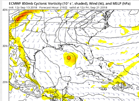
0 likes
Personal Forecast Disclaimer:
The posts in this forum are NOT official forecast and should not be used as such. They are just the opinion of the poster and may or may not be backed by sound meteorological data. They are NOT endorsed by any professional institution or storm2k.org. For official information, please refer to the NHC and NWS products.
The posts in this forum are NOT official forecast and should not be used as such. They are just the opinion of the poster and may or may not be backed by sound meteorological data. They are NOT endorsed by any professional institution or storm2k.org. For official information, please refer to the NHC and NWS products.
Re: ATL: ISAAC - Models
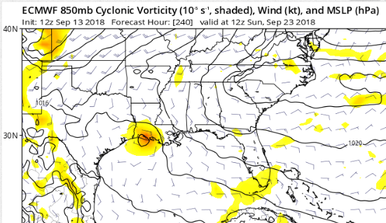
SoupBone wrote:At 192 hours, 12Z Euro bringing a weak system heading to the Central GoM.
[]https://s22.postimg.cc/t9jgcom81/wave.png[/url]
At least the Euro is more consistent now. Before it was development one run to poof another run.
1 likes
The following post is NOT an official forecast and should not be used as such. It is just the opinion of the poster and may or may not be backed by sound meteorological data. It is NOT endorsed by any professional institution including storm2k.org For Official Information please refer to the NHC and NWS products.
Re: ATL: ISAAC - Models
Whatever it is here is very weak.
0 likes
Personal Forecast Disclaimer:
The posts in this forum are NOT official forecast and should not be used as such. They are just the opinion of the poster and may or may not be backed by sound meteorological data. They are NOT endorsed by any professional institution or storm2k.org. For official information, please refer to the NHC and NWS products.
The posts in this forum are NOT official forecast and should not be used as such. They are just the opinion of the poster and may or may not be backed by sound meteorological data. They are NOT endorsed by any professional institution or storm2k.org. For official information, please refer to the NHC and NWS products.
-
Stormcenter
- S2K Supporter

- Posts: 6689
- Joined: Wed Sep 03, 2003 11:27 am
- Location: Houston, TX
Re: ATL: ISAAC - Models
As long as EURO shows something even if minimal should be concerning. IMO
2 likes
Re: ATL: ISAAC - Models
Stormcenter wrote:As long as EURO shows something even if minimal should be concerning. IMO
It's just one run. What we're looking for is trends, not really intensity. It looks ragged as hell right now, so I still have my doubts that it even survives the Western Caribbean, but the NHC thinks it does so we'll see in a few days!
0 likes
Personal Forecast Disclaimer:
The posts in this forum are NOT official forecast and should not be used as such. They are just the opinion of the poster and may or may not be backed by sound meteorological data. They are NOT endorsed by any professional institution or storm2k.org. For official information, please refer to the NHC and NWS products.
The posts in this forum are NOT official forecast and should not be used as such. They are just the opinion of the poster and may or may not be backed by sound meteorological data. They are NOT endorsed by any professional institution or storm2k.org. For official information, please refer to the NHC and NWS products.
-
mcheer23

- Professional-Met

- Posts: 441
- Age: 32
- Joined: Sun Jun 24, 2012 8:24 pm
- Location: Sugar Land, Texas
Re: ATL: ISAAC - Models
SoupBone wrote:Stormcenter wrote:As long as EURO shows something even if minimal should be concerning. IMO
It's just one run. What we're looking for is trends, not really intensity. It looks ragged as hell right now, so I still have my doubts that it even survives the Western Caribbean, but the NHC thinks it does so we'll see in a few days!
Back to back EURO runs show a storm generally into SW Louisiana
1 likes
Re: ATL: ISAAC - Models
mcheer23 wrote:SoupBone wrote:Stormcenter wrote:As long as EURO shows something even if minimal should be concerning. IMO
It's just one run. What we're looking for is trends, not really intensity. It looks ragged as hell right now, so I still have my doubts that it even survives the Western Caribbean, but the NHC thinks it does so we'll see in a few days!
Back to back EURO runs show a storm generally into SW Louisiana
Right and days before it went from poof to weak system heading west to poof, so I agree with what you're suggesting, but a few days ago, the trend was dying out in the western Carribean too, multiple runs in a row. In your opinion, does this Euro trend outweigh the previous days trends?
0 likes
Personal Forecast Disclaimer:
The posts in this forum are NOT official forecast and should not be used as such. They are just the opinion of the poster and may or may not be backed by sound meteorological data. They are NOT endorsed by any professional institution or storm2k.org. For official information, please refer to the NHC and NWS products.
The posts in this forum are NOT official forecast and should not be used as such. They are just the opinion of the poster and may or may not be backed by sound meteorological data. They are NOT endorsed by any professional institution or storm2k.org. For official information, please refer to the NHC and NWS products.
-
mcheer23
- Professional-Met
- Posts: 441
- Age: 32
- Joined: Sun Jun 24, 2012 8:24 pm
- Location: Sugar Land, Texas
Re: ATL: ISAAC - Models
Here is a model breakdown
00Z EURO brought Issac into far SW Louisiana
12z EURO brought Issac into SW Louisiana..but weaker......
FWIW..CMC takes Issac into the TX/MX border....
ICON moves Issac into the Gulf moving NW near the Louisiana coast as a 969mb Hurricane....
JMA 1003 mb storm moving into the NW gulf.
GFS...not much
HWRF...weak.
Keep an eye on Issac..Nothing to be worried about right now..just stay weather aware...
EURO ensembles out in less than an hour...
2 likes

Re: ATL: ISAAC - Models
SoupBone wrote:mcheer23 wrote:SoupBone wrote:
It's just one run. What we're looking for is trends, not really intensity. It looks ragged as hell right now, so I still have my doubts that it even survives the Western Caribbean, but the NHC thinks it does so we'll see in a few days!
Back to back EURO runs show a storm generally into SW Louisiana
Right and days before it went from poof to weak system heading west to poof, so I agree with what you're suggesting, but a few days ago, the trend was dying out in the western Carribean too, multiple runs in a row. In your opinion, does this Euro trend outweigh the previous days trends?
It should, being one or two days closer to the event (the storm dying off or not.)
0 likes

Re: ATL: ISAAC - Models
12z ensembles are way less aggressive than 0z for the Euro. Still have to keep an eye out though.
0 likes
Re: ATL: ISAAC - Models
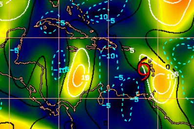
I know shear can change and fast, but it's only a day or two away from the expanding shear area. I wonder if this is what causes the (at least temporary) dissipation that models are seeing. It's already ragged as hell, high shear will kick it in the teeth.
0 likes
Personal Forecast Disclaimer:
The posts in this forum are NOT official forecast and should not be used as such. They are just the opinion of the poster and may or may not be backed by sound meteorological data. They are NOT endorsed by any professional institution or storm2k.org. For official information, please refer to the NHC and NWS products.
The posts in this forum are NOT official forecast and should not be used as such. They are just the opinion of the poster and may or may not be backed by sound meteorological data. They are NOT endorsed by any professional institution or storm2k.org. For official information, please refer to the NHC and NWS products.
Re: ATL: ISAAC - Models
SoupBone wrote:I know shear can change and fast, but it's only a day or two away from the expanding shear area. I wonder if this is what causes the (at least temporary) dissipation that models are seeing. It's already ragged as hell, high shear will kick it in the teeth.
https://s22.postimg.cc/w55qb6plt/wave.png
I remember back when the Caribbean was a favorable area for development. It seems like for the past several years now its been a shredder, though.
1 likes
-
toad strangler

- S2K Supporter
- Posts: 4546
- Joined: Sun Jul 28, 2013 3:09 pm
- Location: Earth
- Contact:
Re: ATL: ISAAC - Models
Cpv17 wrote:SoupBone wrote:I know shear can change and fast, but it's only a day or two away from the expanding shear area. I wonder if this is what causes the (at least temporary) dissipation that models are seeing. It's already ragged as hell, high shear will kick it in the teeth.
https://s22.postimg.cc/w55qb6plt/wave.png
I remember back when the Caribbean was a favorable area for development. It seems like for the past several years now its been a shredder, though.
Well, the post 2004/2005 steroid era there are just two systems to come out of the Caribbean (genesis there) that impacted the United States. Yes, I know this is just not a US forum. But the US for context here .... by my estimate....
2012 - Sandy
2017 - Harvey
0 likes
My Weather Station
https://www.wunderground.com/dashboard/pws/KFLPORTS603
https://www.wunderground.com/dashboard/pws/KFLPORTS603
Who is online
Users browsing this forum: No registered users and 60 guests