EURO a bit stronger and a little further north.
Can't wait for the ensembles.
ATL: INVEST 95L - Models
Moderator: S2k Moderators
-
mcheer23

- Professional-Met

- Posts: 441
- Age: 32
- Joined: Sun Jun 24, 2012 8:24 pm
- Location: Sugar Land, Texas
Re: ATL: INVEST 95L - Models
1 likes
-
stormlover2013

Re: ATL: INVEST 95L - Models
mcheer23 wrote:EURO a bit stronger and a little further north.
Can't wait for the ensembles.
Is there a better (more zoomed in) version than the one from Tidbits? From that one, it doesn't appear more north, but it's not easy to see the exact location.
0 likes
Personal Forecast Disclaimer:
The posts in this forum are NOT official forecast and should not be used as such. They are just the opinion of the poster and may or may not be backed by sound meteorological data. They are NOT endorsed by any professional institution or storm2k.org. For official information, please refer to the NHC and NWS products.
The posts in this forum are NOT official forecast and should not be used as such. They are just the opinion of the poster and may or may not be backed by sound meteorological data. They are NOT endorsed by any professional institution or storm2k.org. For official information, please refer to the NHC and NWS products.
-
srainhoutx

- S2K Supporter

- Posts: 6919
- Age: 68
- Joined: Sun Jan 14, 2007 11:34 am
- Location: Haywood County, NC
- Contact:
Re: ATL: INVEST 95L - Models
SoupBone wrote:mcheer23 wrote:EURO a bit stronger and a little further north.
Can't wait for the ensembles.
Is there a better (more zoomed in) version than the one from Tidbits? From that one, it doesn't appear more north, but it's not easy to see the exact location.
Big difference between Baffin Bay in Kennedy County (King Ranchlands) and Port Aransas...
3 likes
Carla/Alicia/Jerry(In The Eye)/Michelle/Charley/Ivan/Dennis/Katrina/Rita/Wilma/Ike/Harvey
Member: National Weather Association
Wx Infinity Forums
http://wxinfinity.com/index.php
Facebook.com/WeatherInfinity
Twitter @WeatherInfinity
Member: National Weather Association
Wx Infinity Forums
http://wxinfinity.com/index.php
Facebook.com/WeatherInfinity
Twitter @WeatherInfinity
-
wxman22

- Category 5

- Posts: 1943
- Joined: Mon Jan 30, 2006 12:39 am
- Location: Wichita Falls, TX
- Contact:
Re: ATL: INVEST 95L - Models
Yep Euro shows a landfall around Aransas Pass now.
https://weather.us/model-charts/euro/te ... 2100z.html
https://weather.us/model-charts/euro/te ... 2100z.html
1 likes
Re: ATL: INVEST 95L - Models
srainhoutx wrote:SoupBone wrote:mcheer23 wrote:EURO a bit stronger and a little further north.
Can't wait for the ensembles.
Is there a better (more zoomed in) version than the one from Tidbits? From that one, it doesn't appear more north, but it's not easy to see the exact location.
Big difference between Baffin Bay in Kennedy County (King Ranchlands) and Port Aransas...
Yeah I get that, but if the reference point is that one from Tidbits, it's not easy to see it make landfall as it jumps in 24 hour increments (for me). Not disputing that it did.
0 likes
Personal Forecast Disclaimer:
The posts in this forum are NOT official forecast and should not be used as such. They are just the opinion of the poster and may or may not be backed by sound meteorological data. They are NOT endorsed by any professional institution or storm2k.org. For official information, please refer to the NHC and NWS products.
The posts in this forum are NOT official forecast and should not be used as such. They are just the opinion of the poster and may or may not be backed by sound meteorological data. They are NOT endorsed by any professional institution or storm2k.org. For official information, please refer to the NHC and NWS products.
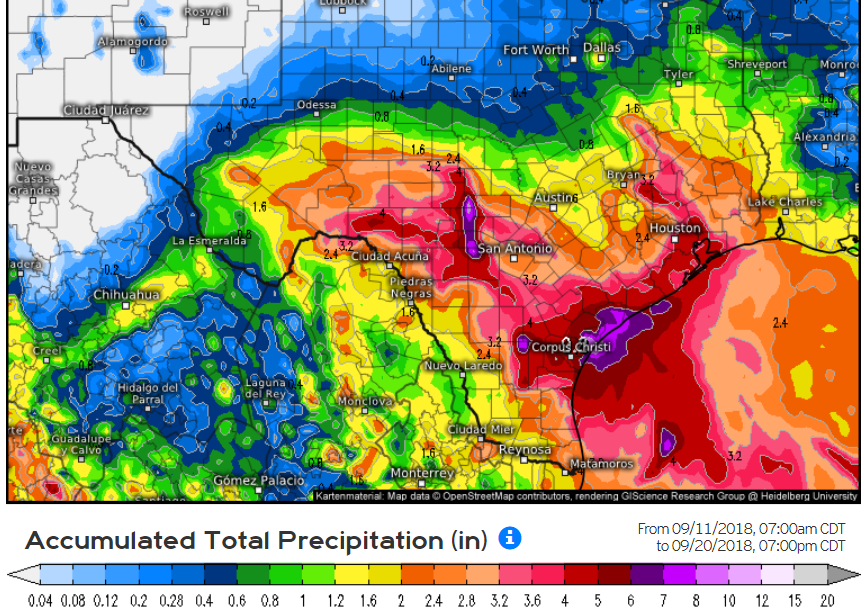
Re: ATL: INVEST 95L - Models
Euro's rainfall estimates modeling.
2 likes
Personal Forecast Disclaimer:
The posts in this forum are NOT official forecast and should not be used as such. They are just the opinion of the poster and may or may not be backed by sound meteorological data. They are NOT endorsed by any professional institution or storm2k.org. For official information, please refer to the NHC and NWS products.
The posts in this forum are NOT official forecast and should not be used as such. They are just the opinion of the poster and may or may not be backed by sound meteorological data. They are NOT endorsed by any professional institution or storm2k.org. For official information, please refer to the NHC and NWS products.
-
wxGuy
Re: ATL: INVEST 95L - Models
S TX Strong TS or CAT 1, depending on other factors as why to why the track might move in the next few days, All Texas Coast Should be monitoring this storm imo


2 likes
-
sphelps8681
- Category 2

- Posts: 785
- Joined: Thu Aug 16, 2007 5:37 pm
- Location: Somewhere over the rainbow
Re: ATL: INVEST 95L - Models
mcheer23 wrote:RGEM is further north. Near matagorda
How much rain do you think for SE Texas? Seems we will be on the wet side a little bit.
0 likes
-
wxman22
- Category 5
- Posts: 1943
- Joined: Mon Jan 30, 2006 12:39 am
- Location: Wichita Falls, TX
- Contact:
Re: ATL: INVEST 95L - Models
The ICON shifted a little north Around the San Antonio Bay/Matagorda Bay areas
0 likes

Re: ATL: INVEST 95L - Models
mcheer23 wrote:RGEM is further north. Near matagorda
Looks weaker than it has but that’s been a trend today with it. It still brings up some squalls into SE TX. Hopefully they won’t get too much training.
0 likes

Re: ATL: INVEST 95L - Models
The 0z GFS appear to have the strongest vorticity around Corpus Christi and Port Aransas
0 likes
Re: ATL: INVEST 95L - Models
If I'm seeing this correctly, and yes I am kind of half asleep, the recent Euro does nothing with our friend 95L as far as development goes. It looks like it brings him in between Corpus Christi and Baffin Bay, though the resolution I see it is not good so please correct me on landfall.
0 likes
Personal Forecast Disclaimer:
The posts in this forum are NOT official forecast and should not be used as such. They are just the opinion of the poster and may or may not be backed by sound meteorological data. They are NOT endorsed by any professional institution or storm2k.org. For official information, please refer to the NHC and NWS products.
The posts in this forum are NOT official forecast and should not be used as such. They are just the opinion of the poster and may or may not be backed by sound meteorological data. They are NOT endorsed by any professional institution or storm2k.org. For official information, please refer to the NHC and NWS products.
-
HouTXmetro

- Category 5
- Posts: 3949
- Joined: Sun Jun 13, 2004 6:00 pm
- Location: District of Columbia, USA
Re: ATL: INVEST 95L - Models
Harvey traversed this same area and the initial NHC forecast was a Tropical Storm making landfall. We all know that intensity forecast was way off. THE GOM is boiling and if the upper level conditions become more favorable, this thing can explode. We've seen it before.
0 likes
[Disclaimer: My Amateur Opinion, please defer to your local authorities or the NHC for Guidance.]

Re: ATL: INVEST 95L - Models
06Z HWRF showing a 46mph TS landfall near Matagorda on Friday
http://moe.met.fsu.edu/cgi-bin/hwrftc2.cgi?time=2018091206-invest95l&field=Sea+Level+Pressure&hour=Animation
http://moe.met.fsu.edu/cgi-bin/hwrftc2.cgi?time=2018091206-invest95l&field=Sea+Level+Pressure&hour=Animation
0 likes
-
wxman22
- Category 5
- Posts: 1943
- Joined: Mon Jan 30, 2006 12:39 am
- Location: Wichita Falls, TX
- Contact:
Re: ATL: INVEST 95L - Models
12z RGEM develops 95L into a tropical storm before landfall fwiw

1 likes
Re: ATL: INVEST 95L - Models
The latest GFS continues to show a sloppy mess, but undeveloped into the Texas coast. Euro coming up!
0 likes
Personal Forecast Disclaimer:
The posts in this forum are NOT official forecast and should not be used as such. They are just the opinion of the poster and may or may not be backed by sound meteorological data. They are NOT endorsed by any professional institution or storm2k.org. For official information, please refer to the NHC and NWS products.
The posts in this forum are NOT official forecast and should not be used as such. They are just the opinion of the poster and may or may not be backed by sound meteorological data. They are NOT endorsed by any professional institution or storm2k.org. For official information, please refer to the NHC and NWS products.
Re: ATL: INVEST 95L - Models
RGEM consistent with the spin up and consistent with coming in a with a little higher pressure over time. Currently it has 95L making landfall around Corpus and spins/wobbles down to the RGV. Looks like a TD or minimal TS Kirk at 1009mb which isn’t very low.
https://www.tropicaltidbits.com/analysi ... 91218&fh=6
https://www.tropicaltidbits.com/analysi ... 91218&fh=6
0 likes
Who is online
Users browsing this forum: No registered users and 66 guests