

CPAC: OLIVIA - Post-Tropical
Moderator: S2k Moderators
Re: EPAC: OLIVIA - Hurricane
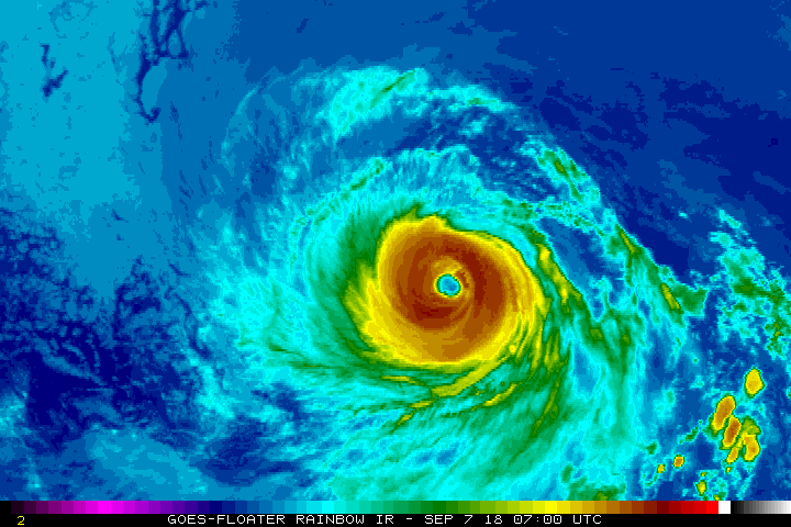
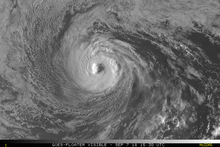
Her eye has gotten bigger and trying at some colder tops this morning after weakening some overnight. First visible of the days will be pretty to see.
4 likes
The above post and any post by Ntxw is NOT an official forecast and should not be used as such. It is just the opinion of the poster and may or may not be backed by sound meteorological data. It is NOT endorsed by any professional institution including Storm2k. For official information, please refer to NWS products.
Help support Storm2K!

-
Kingarabian

- S2K Supporter

- Posts: 16365
- Joined: Sat Aug 08, 2009 3:06 am
- Location: Honolulu, Hawaii
-
Kingarabian
- S2K Supporter
- Posts: 16365
- Joined: Sat Aug 08, 2009 3:06 am
- Location: Honolulu, Hawaii
Re: EPAC: OLIVIA - Hurricane
No letup in microwave presentation. Practically pristine.

4 likes
RIP Kobe Bryant
Re: EPAC: OLIVIA - Hurricane
0 likes
The above post and any post by Ntxw is NOT an official forecast and should not be used as such. It is just the opinion of the poster and may or may not be backed by sound meteorological data. It is NOT endorsed by any professional institution including Storm2k. For official information, please refer to NWS products.
Help support Storm2K!
Help support Storm2K!
-
Kingarabian
- S2K Supporter
- Posts: 16365
- Joined: Sat Aug 08, 2009 3:06 am
- Location: Honolulu, Hawaii
Re: EPAC: OLIVIA - Hurricane
06z GFS showed this affecting Maui, but this 12z run will be back east towards the Big Island.
06z HWRF shifted west and kept it weak north of Maui and Oahu, while 06z HMON had a strong TS into Maui.
06z HWRF shifted west and kept it weak north of Maui and Oahu, while 06z HMON had a strong TS into Maui.
0 likes
RIP Kobe Bryant
-
wxman57

- Moderator-Pro Met

- Posts: 23175
- Age: 68
- Joined: Sat Jun 21, 2003 8:06 pm
- Location: Houston, TX (southwest)
Re: EPAC: OLIVIA - Hurricane
It's hard to hit Hawaii from the east (and have much steam left). Will probably be a weak TS or TD when it reaches the islands.
4 likes
-
Kingarabian
- S2K Supporter
- Posts: 16365
- Joined: Sat Aug 08, 2009 3:06 am
- Location: Honolulu, Hawaii
Re: EPAC: OLIVIA - Hurricane
wxman57 wrote:It's hard to hit Hawaii from the east (and have much steam left). Will probably be a weak TS or TD when it reaches the islands.
Models agree here, 12z Euro shows this being a strong TS hitting Maui/Big Island.
Hard to get any track towards Hawaii from the east in general. But we've seen strong hurricanes pass to the north in recent years.
0 likes
RIP Kobe Bryant
-
Kingarabian
- S2K Supporter
- Posts: 16365
- Joined: Sat Aug 08, 2009 3:06 am
- Location: Honolulu, Hawaii
Re: EPAC: OLIVIA - Recon
Looks like they'll keep the G-IV for Florence and send us the AF plane to do sampling instead.
II. PACIFIC REQUIREMENTS
1. HURRICANE OLIVIA
FLIGHT ONE - TEAL 77
A. 09/0000Z
B. AFXXX 0117E OLIVIA
C. 08/1730Z
D. NA
E. NA
F. 24,000 TO 32,000 FT
2. SUCCEEDING DAY OUTLOOK:
A. BEGIN 12-HRLY FIXES ON HURRICANE OLIVIA AT 09/1800Z
NEAR 22.2N 143.7W.
B. A USAF RESERVE WC-130J SYNOPTIC SURVEILLANCE MISSION
AROUND HURRICANE OLIVIA FOR 10/0000Z.
0 likes
RIP Kobe Bryant
-
supercane4867
- Category 5

- Posts: 4966
- Joined: Wed Nov 14, 2012 10:43 am
Re: EPAC: OLIVIA - Hurricane
It all comes down to wind shear. SST and dry air aren't much of a problem. If Iselle can make it to Hawaii from the east I don't see why Olivia can't. It probably will weaken to a 40-50kt TS when reaching the state if shear isn't too bad.
1 likes
-
Kingarabian
- S2K Supporter
- Posts: 16365
- Joined: Sat Aug 08, 2009 3:06 am
- Location: Honolulu, Hawaii
Re: EPAC: OLIVIA - Hurricane
009
WTPZ42 KNHC 072042
TCDEP2
Hurricane Olivia Discussion Number 29
NWS National Hurricane Center Miami FL EP172018
200 PM PDT Fri Sep 07 2018
Olivia continues to slowly weaken. Deep convection in the eyewall
has been gradually decreasing in intensity and coverage, but it
still completely surrounds the eye. A blend of the latest
satellite intensity estimates supports lowering the initial wind
speed to 95 kt. Olivia still has an annular appearance with the
cloud pattern consisting of an inner core with little to no outer
bands.
The hurricane is moving west-northwestward at 14 kt. There
has been no change to the track forecast reasoning. Olivia is
forecast to move west-northwestward for another day or so before
turning to the west, or even west-southwest, as ridging builds to
the north of the system. The NHC track forecast remains near the
middle of the guidance envelope, and in best agreement with the
consensus aids. Based on this forecast, Olivia is expected to cross
into the central Pacific basin by late Saturday and approach the
Hawaiian Islands in 4 to 5 days.
Although Olivia remains in low wind shear conditions, the cyclone
is over fairly cool 25-26 deg C waters. These marginal SSTs and an
increasingly drier and more stable air mass should cause the slow
weakening trend to continue through the forecast period. However,
as mentioned in previous discussions, annular hurricanes like
Olivia often weaken slower than normal in these conditions, so it
is possible Olivia won't weaken as fast as some of the guidance
suggests.
FORECAST POSITIONS AND MAX WINDS
INIT 07/2100Z 20.5N 133.9W 95 KT 110 MPH
12H 08/0600Z 21.1N 135.9W 85 KT 100 MPH
24H 08/1800Z 21.6N 138.5W 75 KT 85 MPH
36H 09/0600Z 21.8N 141.2W 70 KT 80 MPH
48H 09/1800Z 22.0N 143.7W 70 KT 80 MPH
72H 10/1800Z 22.0N 148.0W 65 KT 75 MPH
96H 11/1800Z 21.6N 151.8W 60 KT 70 MPH
120H 12/1800Z 20.5N 156.0W 50 KT 60 MPH
$$
Forecaster Cangialosi
0 likes
RIP Kobe Bryant
-
Kingarabian
- S2K Supporter
- Posts: 16365
- Joined: Sat Aug 08, 2009 3:06 am
- Location: Honolulu, Hawaii
Re: EPAC: OLIVIA - Hurricane
supercane4867 wrote:It all comes down to wind shear. SST and dry air aren't much of a problem. If Iselle can make it to Hawaii from the east I don't see why Olivia can't. It probably will weaken to a 40-50kt TS when reaching the state if shear isn't too bad.
Agreed.
It can easily be a hurricane on approach to the Hawaiian islands. Right now the NHC is keeping cool SSTs and a drier air mass the primary reasons for weakening.
Using the 12z GFS shear chart (12z Euro is pretty much the same):
1. We can go back to Norman 48 hours ago and see how it was able to intensify and survive in the face of 30-50kts of shear. Notice how because it's a deep TC, it bought itself time and "pushed" the shear axis out of the way until it eventually succumbed.

2. Look at the shear forecast for Olivia on this GFS run. Shear has dropped from 30-50kts to 20-30kts, and even less closer to the big island. Although this seems unfavorable, Hector, Lane, Miriam, and recently Norman (all well developed hurricanes in this area) have proven that it's possible to resist this amount of shear for a period of time.

1 likes
RIP Kobe Bryant
-
BYG Jacob
Re: EPAC: OLIVIA - Hurricane
And that shear looks convergent and would instead help vent her rather than weaken her.
0 likes
-
Kingarabian
- S2K Supporter
- Posts: 16365
- Joined: Sat Aug 08, 2009 3:06 am
- Location: Honolulu, Hawaii
Re: EPAC: OLIVIA - Hurricane
18z GFS shows Olivia missing east of the Big Island due to a much stronger ridge:

12z UKMET also shows this solution. Probably our only saving grace. But the 12Z CMC, Navy, and Euro show a slightly weaker ridge and thus affect the islands. It's going to be a close call.
12z UKMET also shows this solution. Probably our only saving grace. But the 12Z CMC, Navy, and Euro show a slightly weaker ridge and thus affect the islands. It's going to be a close call.
1 likes
RIP Kobe Bryant
-
Kingarabian
- S2K Supporter
- Posts: 16365
- Joined: Sat Aug 08, 2009 3:06 am
- Location: Honolulu, Hawaii
Re: EPAC: OLIVIA - Hurricane
Still going despite 25C waters and RH in the 30's.

00z Euro Oahu landfall:

00z GFS and 00z UKMET east of the Big Island:

00z Euro Oahu landfall:
00z GFS and 00z UKMET east of the Big Island:
1 likes
RIP Kobe Bryant
-
Kingarabian
- S2K Supporter
- Posts: 16365
- Joined: Sat Aug 08, 2009 3:06 am
- Location: Honolulu, Hawaii
Re: EPAC: OLIVIA - Hurricane
Hurricane Olivia Discussion Number 31
NWS National Hurricane Center Miami FL EP172018
200 AM PDT Sat Sep 08 2018
The satellite presentation of Olivia has continued to degrade
overnight with the surrounding ring of deep convection warming
and the eye becoming less distinct. Dvorak T-numbers have decreased
and a blend of current intensity (CI) numbers from TAFB and SAB, and
ADT and SATCON estimates from UW/CIMSS yields an initial wind speed
of 80 kt. Although the vertical wind shear is expected to remain
low over Olivia, the hurricane will be moving over marginal sea
surface temperatures of 25-26C, and into a dry mid-level
environment. These factors are expected to cause gradual weakening
over the next 24 hours. After that time, slightly warmer SSTs along
the forecast track should slow or halt the weakening process, and
little change in strength is expected between 24 and 72 hours.
Increasing southwesterly shear by day 3 is likely to result in
additional weakening later in the forecast period. The NHC
intensity forecast is similar to the previous advisory and is
between the HFIP corrected consensus model and the IVCN consensus
aid.
Olivia is moving west-northwestward or 285/13 kt. A strong
deep-layer ridge that is building westward across the central
Pacific should steer Olivia generally westward over the next 2-3
days. After that time, most of the track guidance takes Olivia
west-southwestward as it comes under the influence of the
northeasterly trade wind flow. Although the track models are fairly
unanimous in taking Olivia west-southwestward, there is large
cross-track spread in the guidance at 72 hours and beyond. The HWRF
and ECMWF are along the northern side of the guidance envelope while
the GFS and UKMET bracket the southern side. Given the large amount
of spread, the official forecast is again near the TVCN and HFIP
consensus models at 72-120 h. On the forecast track, Olivia is
expected to cross into the central Pacific basin later today and
approach the Hawaiian Islands early next week.
KEY MESSAGES
1. Olivia is forecast to approach the main Hawaiian Islands from
the east early next week, but it is too soon to determine the exact
location and magnitude of any impacts. Interests in Hawaii should
monitor the progress of Olivia this weekend and use this time to
enact your hurricane action plan.
2. Do not focus on the exact track or intensity forecast, or any
specific landfall location, as errors can be large at extended time
ranges. Tropical storm or hurricane conditions could be felt
anywhere in the islands as significant impacts could extend well
away from the center.
FORECAST POSITIONS AND MAX WINDS
INIT 08/0900Z 21.2N 136.6W 80 KT 90 MPH
12H 08/1800Z 21.5N 138.7W 70 KT 80 MPH
24H 09/0600Z 21.7N 141.5W 65 KT 75 MPH
36H 09/1800Z 21.8N 144.0W 65 KT 75 MPH
48H 10/0600Z 21.8N 146.2W 65 KT 75 MPH
72H 11/0600Z 21.5N 150.0W 65 KT 75 MPH
96H 12/0600Z 20.5N 154.0W 55 KT 65 MPH
120H 13/0600Z 19.2N 159.0W 45 KT 50 MPH
$$
Forecaster Brown
0 likes
RIP Kobe Bryant
-
Kingarabian
- S2K Supporter
- Posts: 16365
- Joined: Sat Aug 08, 2009 3:06 am
- Location: Honolulu, Hawaii
Re: EPAC: OLIVIA - Hurricane
Assuming Olivia remains a vertically stacked system for the rest of the forecast period, the next 36 hours will likely determine which Islands will be affected. If Olivia takes a track north of the NHC/CPHC's forecast then it'll be Kauai/Oahu/Molokai at play. If Olivia follows the NHC forecast it'll likely be Maui/Lanai/Big Island. If Olivia dips south of the NHC forecast then it'll likely be a Big Island brush/miss the Big Island to the east.

The posts in this forum are NOT official forecast and should not be used as such. They are just the opinion of the poster and may or may not be backed by sound meteorological data. They are NOT endorsed by any professional institution or STORM2K. For official information, please refer to products from the National Hurricane Center and National Weather Service.
0 likes
RIP Kobe Bryant

Re: EPAC: OLIVIA - Hurricane
Are we sure there's going to be much left by the time it gets to Hawaii, it currently tracking over cooler waters and around a dryer air environment.
Maybe it will flare up again as it gets closer to Hawaii and warmer SSTs.

Maybe it will flare up again as it gets closer to Hawaii and warmer SSTs.
0 likes
-
cycloneye

- Admin

- Posts: 149495
- Age: 69
- Joined: Thu Oct 10, 2002 10:54 am
- Location: San Juan, Puerto Rico
Re: EPAC: OLIVIA - Hurricane
Hurricane Olivia Discussion Number 32...Corrected
NWS National Hurricane Center Miami FL EP172018
800 AM PDT Sat Sep 08 2018
Corrected initial intensity in the text from 70 to 75 kt.
Satellite images indicate that Olivia continues to slowly weaken.
The eyewall convection has warmed during the past several hours,
with some breaks noted in the northwestern quadrant. A blend of
the various intensity estimates gives a value of 75 kt for this
advisory. Olivia is forecast to stay a hurricane for the next
couple of days while the system is experiencing light shear,
balanced by very dry air aloft and marginal but warming SSTs.
While the forecast is flat-lined through 48 hours, don't be
surprised if the system's intensity fluctuates upward at times, as
many eastern Pacific cyclones have done so this season within a
marginal environment. After the weekend, most of the guidance
indicates that westerly shear should increase, which will likely
cause weakening while Olivia approaches the Hawaiian Islands. The
new intensity forecast is basically an update of the previous one
and is close to the consensus.
Olivia has turned westward and is moving 275/13. A building
subtropical ridge should steer the hurricane basically due westward
for the next couple of days, and the model guidance is in good
agreement during this time. Thereafter, a mid-level ridge over
Hawaii will impart some northerly steering flow on Olivia, which
should cause the cyclone to move west-southwestward toward the
main Hawaiian Islands. There isn't great agreement on how fast it
will turn, however, due to the forecast depth of Olivia. The
guidance generally indicates a stronger system will turn more
southwestward, like the GFS or UKMET solutions, while a weaker
system would have less of a turn, like the ECMWF or HWRF solutions.
The model consensus has barely budged since the previous advisory,
so little change has been made. Since the track seems to be
dependent on the intensity at long range, this isn't a particularly
confident forecast.
KEY MESSAGES
1. Olivia is forecast to approach the main Hawaiian Islands from
the east early next week, but it is too soon to determine the exact
location and magnitude of any impacts. Interests in Hawaii should
monitor the progress of Olivia this weekend and use this time to
enact your hurricane action plan.
2. Do not focus on the exact track or intensity forecast, or any
specific landfall location, as errors can be large at extended time
ranges. Tropical storm or hurricane conditions could be felt
anywhere in the islands as significant impacts could extend well
away from the center.
FORECAST POSITIONS AND MAX WINDS
INIT 08/1500Z 21.4N 138.0W 75 KT 85 MPH
12H 09/0000Z 21.6N 140.1W 65 KT 75 MPH
24H 09/1200Z 21.7N 142.8W 65 KT 75 MPH
36H 10/0000Z 21.7N 145.2W 65 KT 75 MPH
48H 10/1200Z 21.7N 147.2W 65 KT 75 MPH
72H 11/1200Z 21.2N 151.0W 60 KT 70 MPH
96H 12/1200Z 20.2N 155.6W 55 KT 65 MPH
120H 13/1200Z 19.0N 160.5W 45 KT 50 MPH
$$
Forecaster Blake
0 likes
Visit the Caribbean-Central America Weather Thread where you can find at first post web cams,radars
and observations from Caribbean basin members Click Here
and observations from Caribbean basin members Click Here
-
Kingarabian
- S2K Supporter
- Posts: 16365
- Joined: Sat Aug 08, 2009 3:06 am
- Location: Honolulu, Hawaii
Re: EPAC: OLIVIA - Hurricane
NDG wrote:Are we sure there's going to be much left by the time it gets to Hawaii, it currently tracking over cooler waters and around a dryer air environment.
Maybe it will flare up again as it gets closer to Hawaii and warmer SSTs.
[img]https://i.imgur.com/zXREMiK.jpg[/ig]
Models keep it this way until it reaches Hawaii. But it will enter an area where Hector, Lane, Miriam, and Norman all reintensified.
0 likes
RIP Kobe Bryant
-
Kingarabian
- S2K Supporter
- Posts: 16365
- Joined: Sat Aug 08, 2009 3:06 am
- Location: Honolulu, Hawaii
Re: EPAC: OLIVIA - Hurricane
Not sure what Blake means by a stronger system going further south. The two models that have this going south (UKMET and GFS) arguably keep this just as week as the Euro and HWRF.
0 likes
RIP Kobe Bryant
Who is online
Users browsing this forum: No registered users and 53 guests