ATL: FLORENCE - Post-Tropical - Discussion
Moderator: S2k Moderators
-
MississippiWx

- S2K Supporter

- Posts: 1720
- Joined: Sat Aug 14, 2010 1:44 pm
- Location: Hattiesburg, Mississippi
Re: ATL: FLORENCE - Hurricane - Discussion
Florence is heading into an area that has been favorable for tropical cyclones all season. While the systems that have developed there have been non-tropical in nature, they eventually became true warm core lows. This area has sea surface temps well above normal, and if the upper level winds allow, this will be a formidable storm on approach to the US/Bermuda. Crazy that it’s a Category 4 now. It’s very difficult for a hurricane of this magnitude to make it all the way across the Atlantic to the US, especially at this latitude. I have my doubts because of that, but the ridging that has been in place across the East makes you wonder if it’s possible as long as Florence misses the first trough. Interesting times.
1 likes
This post is not an official forecast and should not be used as such. It is just the opinion of MississippiWx and may or may not be backed by sound meteorological data. It is not endorsed by any professional institution including storm2k.org. For Official Information please refer to the NHC and NWS products.

Re: ATL: FLORENCE - Hurricane - Discussion
I can't post the Gif that this Met from Bermuda posted, but it does show the current ridge digging southward as Aric was showing on a steering graphic earlier.
Eric Drewitz
@DrewitzWx@DrewitzWx
GOES16 VIS also shows well the ridging over the NE'rn US and Canadian Maritime sinking S'ward which will potentially help keep #Florence on the W'rn side of the model spread. The track is going to depend on this Bermuda-Azores High. #Tropics #Atlantic
Eric Drewitz
@DrewitzWx@DrewitzWx
GOES16 VIS also shows well the ridging over the NE'rn US and Canadian Maritime sinking S'ward which will potentially help keep #Florence on the W'rn side of the model spread. The track is going to depend on this Bermuda-Azores High. #Tropics #Atlantic
0 likes
The posts or stuff said are NOT an official forecast. Please look to the NHC and NWS for official forecasts and products.
Floyd-1999, Frances-2004, Jeanne-2004, Fay-2008, Beryl-2012, Debby-2012, Colin-2016, Hermine-2016, Julia-2016, Matthew-2016, Irma-2017, Elsa-2021, Idalia-2023, Debby-2024, Helene-2024.
Go Gators! Go Jags!
Floyd-1999, Frances-2004, Jeanne-2004, Fay-2008, Beryl-2012, Debby-2012, Colin-2016, Hermine-2016, Julia-2016, Matthew-2016, Irma-2017, Elsa-2021, Idalia-2023, Debby-2024, Helene-2024.
Go Gators! Go Jags!

Re: ATL: FLORENCE - Hurricane - Discussion
It has gained quite a lot of latitude today.
0 likes
Igor 2010, Sandy 2012, Fay 2014, Gonzalo 2014, Joaquin 2015, Nicole 2016, Humberto 2019, Imelda 2025
I am only a tropical weather enthusiast. My predictions are not official and may or may not be backed by sound meteorological data. For official information, please refer to the NHC and NWS products.
I am only a tropical weather enthusiast. My predictions are not official and may or may not be backed by sound meteorological data. For official information, please refer to the NHC and NWS products.
-
SconnieCane
- Category 5

- Posts: 1013
- Joined: Thu Aug 02, 2018 5:29 pm
- Location: Madison, WI
Re: ATL: FLORENCE - Hurricane - Discussion
[quote="Ntxw"]Raw T's have dropped a bit from earlier today with the warming cloud tops. Still a solid major.
Great to see the ssd.noaa.gov floaters are back up for the Atlantic, at least for the moment. Would have liked to have one for Gordon, although it became kind of a moot point since he didn't take off like I was thinking he might.
Great to see the ssd.noaa.gov floaters are back up for the Atlantic, at least for the moment. Would have liked to have one for Gordon, although it became kind of a moot point since he didn't take off like I was thinking he might.
0 likes
-
AutoPenalti
- Category 5
- Posts: 4091
- Age: 29
- Joined: Mon Aug 17, 2015 4:16 pm
- Location: Ft. Lauderdale, Florida
Re: ATL: FLORENCE - Hurricane - Discussion
JaxGator wrote:I can't post the Gif that this Met from Bermuda posted, but it does show the current ridge digging southward as Aric was showing on a steering graphic earlier.
Eric Drewitz
@DrewitzWx@DrewitzWx
GOES16 VIS also shows well the ridging over the NE'rn US and Canadian Maritime sinking S'ward which will potentially help keep #Florence on the W'rn side of the model spread. The track is going to depend on this Bermuda-Azores High. #Tropics #Atlantic
He was referring to this graphic on tropical tidbits.

1 likes
The posts in this forum are NOT official forecasts and should not be used as such. They are just the opinion of the poster and may or may not be backed by sound meteorological data. They are NOT endorsed by any professional institution or STORM2K. For official information, please refer to products from the NHC and NWS.
Model Runs Cheat Sheet:
GFS (5:30 AM/PM, 11:30 AM/PM)
HWRF, GFDL, UKMET, NAVGEM (6:30-8:00 AM/PM, 12:30-2:00 AM/PM)
ECMWF (1:45 AM/PM)
TCVN is a weighted averaged
-
cycloneye

- Admin

- Posts: 149501
- Age: 69
- Joined: Thu Oct 10, 2002 10:54 am
- Location: San Juan, Puerto Rico
Re: ATL: FLORENCE - Hurricane - Discussion
00z Best Track stays at 115 kts.
AL, 06, 2018090600, , BEST, 0, 231N, 469W, 115, 953, HU
1 likes
Visit the Caribbean-Central America Weather Thread where you can find at first post web cams,radars
and observations from Caribbean basin members Click Here
and observations from Caribbean basin members Click Here

Re: ATL: FLORENCE - Hurricane - Discussion
The current ridge is well outlined in the water vapor imagery and there is a weakness on the western periphery that might offer an escape path if the high rolls east far enough..
Major hurricanes tend to stir up the upper level steering environment so a lot can change in a few days.
The high with the clockwise circulation is centered off Cape Cod and there is a trough currently pulling through the great lakes.
Major hurricanes tend to stir up the upper level steering environment so a lot can change in a few days.
The high with the clockwise circulation is centered off Cape Cod and there is a trough currently pulling through the great lakes.
Last edited by Nimbus on Wed Sep 05, 2018 8:03 pm, edited 1 time in total.
0 likes
-
AutoPenalti
- Category 5
- Posts: 4091
- Age: 29
- Joined: Mon Aug 17, 2015 4:16 pm
- Location: Ft. Lauderdale, Florida
Re: ATL: FLORENCE - Hurricane - Discussion
Nimbus wrote:The current ridge is well outlined in the water vapor imagery and there is a weakness on the western periphery that might offer an escape path if the high rolls east far enough..
Major hurricanes tend to stir up the upper level steering environment so a lot can change in a few days.
Can you outline the ridge for me because I can't recognize it..
0 likes
The posts in this forum are NOT official forecasts and should not be used as such. They are just the opinion of the poster and may or may not be backed by sound meteorological data. They are NOT endorsed by any professional institution or STORM2K. For official information, please refer to products from the NHC and NWS.
Model Runs Cheat Sheet:
GFS (5:30 AM/PM, 11:30 AM/PM)
HWRF, GFDL, UKMET, NAVGEM (6:30-8:00 AM/PM, 12:30-2:00 AM/PM)
ECMWF (1:45 AM/PM)
TCVN is a weighted averaged

Re: ATL: FLORENCE - Hurricane - Discussion
Florence is far away, and I’ve heard Bermuda and the East coast mentioned, but I haven’t heard anything about Florida. Do they seem likely to be all clear down there? Just some opinions would be appreciated bc I know how storms can change Thank you.
0 likes
-
floridasun78
- Category 5
- Posts: 3755
- Joined: Sun May 17, 2009 10:16 pm
- Location: miami fl
Re: ATL: FLORENCE - Hurricane - Discussion
sunnyday wrote:Florence is far away, and I’ve heard Bermuda and the East coast mentioned, but I haven’t heard anything about Florida. Do they seem likely to be all clear down there? Just some opinions would be appreciated bc I know how storms can change Thank you.
i got feeling weakness will be their if stay strong high will pull it up i seen it gaining latitude today
0 likes
-
storm_in_a_teacup

- Category 2

- Posts: 500
- Age: 33
- Joined: Wed Aug 16, 2017 5:01 pm
- Location: Huntsville, Alabama (originally from Houston)
- Contact:
Re: ATL: FLORENCE - Hurricane - Discussion
RL3AO wrote:The first tweet of that bunch is probably the most important. We have a typhoon near Japan that is going to make significant impacts to the mid-latitude steering flow for a hurricane in the middle of the Atlantic. The models are all over the place because this is an extremely complex situation. Probably a lot more complex than normal.
Okay...super late reply (again, sorry) but what exactly do typhoons do to the mid-latitude steering? I've only heard about this maybe once before. Do other tropical cyclones affect it, or just typhoons in the Pacific?
1 likes
I know I can't straddle the atmosphere...just a tiny storm in your teacup, girl.
-
StormyWaters93
- Tropical Low

- Posts: 14
- Joined: Sun Sep 03, 2017 12:55 pm
Re: RE: Re: ATL: FLORENCE - Hurricane - Discussion
I'm really curious about this as well. Been looking into getting a meteorology degree since I'm passionate about weather and I teach myself about things related to it. Also, been stalking storm2k for about 2 years, but just now starting to get involved in the forums.storm_in_a_teacup wrote:RL3AO wrote:The first tweet of that bunch is probably the most important. We have a typhoon near Japan that is going to make significant impacts to the mid-latitude steering flow for a hurricane in the middle of the Atlantic. The models are all over the place because this is an extremely complex situation. Probably a lot more complex than normal.
Okay...super late reply (again, sorry) but what exactly do typhoons do to the mid-latitude steering? I've only heard about this maybe once before. Do other tropical cyclones affect it, or just typhoons in the Pacific?
Sent from my SM-S727VL using Tapatalk
0 likes
Re: ATL: FLORENCE - Hurricane - Discussion
Latest estimate of coordinates (as of 0Z):
AL, 06, 2018090600, , BEST, 0, 231N, 469W, 115, 953, HU
So it is still moving just as NW as it has been. 3 hours earlier it was at 22.7/46.6. So, it has moved 0.4N/0.3W since 5 PM. Still no shift back to the model consensus’ WNW. Just sayin’. Food for thought.
AL, 06, 2018090600, , BEST, 0, 231N, 469W, 115, 953, HU
So it is still moving just as NW as it has been. 3 hours earlier it was at 22.7/46.6. So, it has moved 0.4N/0.3W since 5 PM. Still no shift back to the model consensus’ WNW. Just sayin’. Food for thought.
1 likes
Personal Forecast Disclaimer:
The posts in this forum are NOT official forecasts and should not be used as such. They are just the opinion of the poster and may or may not be backed by sound meteorological data. They are NOT endorsed by any professional institution or storm2k.org. For official information, please refer to the NHC and NWS products.
The posts in this forum are NOT official forecasts and should not be used as such. They are just the opinion of the poster and may or may not be backed by sound meteorological data. They are NOT endorsed by any professional institution or storm2k.org. For official information, please refer to the NHC and NWS products.
-
AutoPenalti
- Category 5
- Posts: 4091
- Age: 29
- Joined: Mon Aug 17, 2015 4:16 pm
- Location: Ft. Lauderdale, Florida
Re: ATL: FLORENCE - Hurricane - Discussion

It's a very choppy set up.
Last edited by AutoPenalti on Wed Sep 05, 2018 8:28 pm, edited 1 time in total.
0 likes
The posts in this forum are NOT official forecasts and should not be used as such. They are just the opinion of the poster and may or may not be backed by sound meteorological data. They are NOT endorsed by any professional institution or STORM2K. For official information, please refer to products from the NHC and NWS.
Model Runs Cheat Sheet:
GFS (5:30 AM/PM, 11:30 AM/PM)
HWRF, GFDL, UKMET, NAVGEM (6:30-8:00 AM/PM, 12:30-2:00 AM/PM)
ECMWF (1:45 AM/PM)
TCVN is a weighted averaged

Re: ATL: FLORENCE - Hurricane - Discussion
storm_in_a_teacup wrote:RL3AO wrote:The first tweet of that bunch is probably the most important. We have a typhoon near Japan that is going to make significant impacts to the mid-latitude steering flow for a hurricane in the middle of the Atlantic. The models are all over the place because this is an extremely complex situation. Probably a lot more complex than normal.
Okay...super late reply (again, sorry) but what exactly do typhoons do to the mid-latitude steering? I've only heard about this maybe once before. Do other tropical cyclones affect it, or just typhoons in the Pacific?
A common occurrence when a strong typhoon re-curves into the mid-latitudes of the west Pacific is the amplification (strengthening) of the ridges and troughs across the entire Pacific. These are commonly called Rossby Wave Trains. In this case, the typhoon merged into a mid-latitude cyclone coming off of Asia (the track of the typhoon shown by the black arrow near Japan. With the energy injected into the jet stream, you had an intensification of two ridges and two troughs downstream almost reaching the west coast of North America.

In this case, the "train" stopped before reaching North America and it's not really fair to say the typhoon with have a direct impact on Florence, but there will be an indirect one. The typhoon has led to a very chaotic pattern in the jet stream across the entire Pacific. Active and chaotic patterns are not good for models when it comes to making a 7 to 10 day forecast. And since what happens in the Pacific impacts the weather of the US and eventually the Atlantic, it makes it harder than usual to get an idea of the upper air pattern in the mid-latitudes beyond five days right now. And that upper air pattern in 7 to 10 days is absolutely key to Florence potentially impacting North America or going safely out to sea.
14 likes
-
Blown Away

- S2K Supporter
- Posts: 10253
- Joined: Wed May 26, 2004 6:17 am
Re: ATL: FLORENCE - Hurricane - Discussion

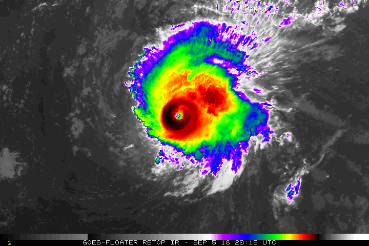
Last few frames Flo seems to be smoothing out to WNW instead on NW... Look at that eye, almost looks annular...
0 likes
Hurricane Eye Experience: David 79, Irene 99, Frances 04, Jeanne 04, Wilma 05… Hurricane Brush Experience: Andrew 92, Erin 95, Floyd 99, Matthew 16, Irma 17, Ian 22, Nicole 22…
-
Hurricane Andrew

- S2K Supporter
- Posts: 1891
- Age: 27
- Joined: Sun May 23, 2010 2:53 pm
- Location: KS
Re: ATL: FLORENCE - Hurricane - Discussion
Blown Away wrote:
Last few frames Flo seems to be smoothing out to WNW instead on NW... Look at that eye, almost looks annular...
What a beauty...eye has clearly expanded over the last hour or two.
2 likes
The Enthusiast
NREMT-AEMT, WX nerd
Irene '11, Sandy '12, Irma '17 (SAR)
"Hard to think we were born to live this way..." -Wage War
Re: ATL: FLORENCE - Hurricane - Discussion
Hurricane Andrew wrote:Blown Away wrote:
Last few frames Flo seems to be smoothing out to WNW instead on NW... Look at that eye, almost looks annular...
What a beauty...eye has clearly expanded over the last hour or two.
So much for the "weakening".
3 likes
Igor 2010, Sandy 2012, Fay 2014, Gonzalo 2014, Joaquin 2015, Nicole 2016, Humberto 2019, Imelda 2025
I am only a tropical weather enthusiast. My predictions are not official and may or may not be backed by sound meteorological data. For official information, please refer to the NHC and NWS products.
I am only a tropical weather enthusiast. My predictions are not official and may or may not be backed by sound meteorological data. For official information, please refer to the NHC and NWS products.

Re: ATL: FLORENCE - Hurricane - Discussion
1 likes
The above post is not official and should not be used as such. It is the opinion of the poster and may or may not be backed by sound meteorological data. It is not endorsed by any professional institution or storm2k.org. For official information, please refer to the NHC and NWS products.
-
drewschmaltz
- S2K Supporter
- Posts: 351
- Joined: Thu Aug 27, 2015 8:19 pm
Re: ATL: FLORENCE - Hurricane - Discussion
48H 05/1800Z 21.5N 48.4W 50 KT 60 MPH
This seems quite a bit off for an advisory issued only 48 hours ago. Not even half of the current intensity.
This seems quite a bit off for an advisory issued only 48 hours ago. Not even half of the current intensity.
3 likes
I HAVE ABSOLUTELY NO IDEA WHAT I'M TALKING ABOUT. PLEASE CONSULT SOMEONE WHO DOES. START WITH THE NHC. ALL POSTS ARE FOR ENTERTAINMENT PURPOSES ONLY.
Who is online
Users browsing this forum: No registered users and 222 guests