ATL: FLORENCE - Models

Moderator: S2k Moderators

Message
Author
txwatcher91
Category 5
Category 5
Posts: 1498
Joined: Tue Aug 02, 2005 2:29 pm

Re: ATL: FLORENCE - Models

#441 Postby txwatcher91 » Tue Sep 04, 2018 1:26 pm

plasticup wrote:
txwatcher91 wrote:Meanwhile the CMC has for several runs now shown a near miss or coastal scraper for NC/VA area.
Image

It gets there via a blocking high at 25N. That is so different from the model consensus and so near in the future (it diverges around 78-90 hours) that it is hard to take seriously.


Yeah the CMC scenario is not likely to occur but it shows there is still a bit of disagreement with the models. GFS has led the way on this one though and has outperformed other models with the intensity it's shown and the track. Similar to Lane, I think the GFS will be the winner again here.
0 likes   

User avatar
Kazmit
Category 5
Category 5
Posts: 2124
Age: 22
Joined: Mon Jul 25, 2016 8:49 am
Location: Williamsburg, VA / Bermuda

Re: ATL: FLORENCE - Models

#442 Postby Kazmit » Tue Sep 04, 2018 1:32 pm

12z Euro shifted west, but not enough to impact Bermuda.
0 likes   
Igor 2010, Sandy 2012, Fay 2014, Gonzalo 2014, Joaquin 2015, Nicole 2016, Humberto 2019

I am only a tropical weather enthusiast. My predictions are not official and may or may not be backed by sound meteorological data. For official information, please refer to the NHC and NWS products.

LarryWx
S2K Supporter
S2K Supporter
Posts: 6305
Joined: Sun Sep 07, 2003 2:04 pm
Location: GA

Re: ATL: FLORENCE - Models

#443 Postby LarryWx » Tue Sep 04, 2018 1:33 pm

12Z Euro is for the 2nd time in a row OTS and misses Bermuda to the east though it is a little closer to Bermuda.
1 likes   
Personal Forecast Disclaimer:
The posts in this forum are NOT official forecasts and should not be used as such. They are just the opinion of the poster and may or may not be backed by sound meteorological data. They are NOT endorsed by any professional institution or storm2k.org. For official information, please refer to the NHC and NWS products.

User avatar
gatorcane
S2K Supporter
S2K Supporter
Posts: 23691
Age: 47
Joined: Sun Mar 13, 2005 3:54 pm
Location: Boca Raton, FL

Re: ATL: FLORENCE - Models

#444 Postby gatorcane » Tue Sep 04, 2018 2:53 pm

Ok stop that UKMET: :double:

Image

12Z Euro ensembles back to a cluster of ensembles taking this West to SE US coast:

Image
3 likes   

User avatar
Nimbus
Category 5
Category 5
Posts: 5300
Joined: Mon Jul 19, 2004 10:54 am

Re: ATL: FLORENCE - Models

#445 Postby Nimbus » Tue Sep 04, 2018 3:02 pm

Hopefully the model runs will stop showing Florence missing the weakness by tomorrow, this is kind of basic for any kind of forecast integrity.
0 likes   

User avatar
Cunxi Huang
Category 1
Category 1
Posts: 329
Age: 27
Joined: Thu Sep 26, 2013 12:17 pm
Location: San Jose, CA
Contact:

Re: ATL: FLORENCE - Models

#446 Postby Cunxi Huang » Tue Sep 04, 2018 3:15 pm

[i mg]http://76.167.74.185/owncloud/index.php/s/PcsafZES3vLALe1/download[/img]

oh man, what are these.
0 likes   
06 SuTY SAOMAI | 09 TY LINFA | 10 TY FANAPI | 10 SuTY MEGI | 16 SuTY MERANTI | 19 SuTY LEKIMA | 24 C2 FRANCINE
DO NOT use my posts for life and death decisions. For official information, please refer to products from your RSMC and national weather agency.

LarryWx
S2K Supporter
S2K Supporter
Posts: 6305
Joined: Sun Sep 07, 2003 2:04 pm
Location: GA

Re: ATL: FLORENCE - Models

#447 Postby LarryWx » Tue Sep 04, 2018 3:26 pm

A further update on the 12Z EPS. Main message: still way too soon for all clear for SE US.

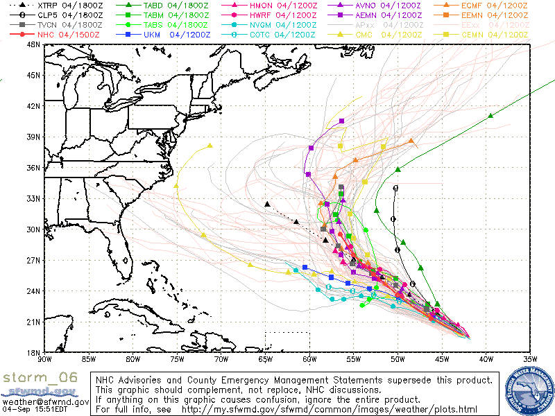
The crucial longitude point is near 60W and the crucial day is ~ Sunday 9/9. That's when ~2/3 of the 51 members, the ones north of 30N, then recurve safely into the north Atlantic. However, ~1/3 of them, which are then located 25-30N and which average somewhat weaker than the recurvers further to the north, stop their northward move and turn left/west due to being trapped by a ridge. Then whereas a few just mill around, the majority of that 1/3 become SE US threats with a whopping 9 TS+ members hitting (almost all Hs), the most of any recent run. Also, there are 2 other members with Hs not far offshore NC at the end of the run. Most (6) of these 9 hits are earlier, 9/12-14: 4 hit near SC/NC border and the other 2 hit near Daytona Beach. However, 3 of them are much later (yes they are from Florence, not the followup which itself hits FL with Hs from 3 members) 9/18-9: 2 hit SC and 1 hits S FL. In addition, one of the earlier 6 H hits comes back offshore and then re-hits the SE with a H on 9/17 at the FL/GA border.
6 likes   
Personal Forecast Disclaimer:
The posts in this forum are NOT official forecasts and should not be used as such. They are just the opinion of the poster and may or may not be backed by sound meteorological data. They are NOT endorsed by any professional institution or storm2k.org. For official information, please refer to the NHC and NWS products.

LarryWx
S2K Supporter
S2K Supporter
Posts: 6305
Joined: Sun Sep 07, 2003 2:04 pm
Location: GA

Re: ATL: FLORENCE - Models

#448 Postby LarryWx » Tue Sep 04, 2018 3:57 pm

I don't have a link, but I just saw a post elsewhere that showed the 12Z UKMET ensembles. They're quite concerning as most of them pass 60W south of 30N and on a westward trajectory just like their operational that Gator posted. :eek:
0 likes   
Personal Forecast Disclaimer:
The posts in this forum are NOT official forecasts and should not be used as such. They are just the opinion of the poster and may or may not be backed by sound meteorological data. They are NOT endorsed by any professional institution or storm2k.org. For official information, please refer to the NHC and NWS products.

Aric Dunn
Category 5
Category 5
Posts: 21238
Age: 42
Joined: Sun Sep 19, 2004 9:58 pm
Location: Ready for the Chase.
Contact:

Re: ATL: FLORENCE - Models

#449 Postby Aric Dunn » Tue Sep 04, 2018 4:43 pm

I would not rule out any scenario at this point.

the 12z yesterday which takes aim at the SE has a more progressive trough over the Canadian maritime. Today's 12z has a slower and more broken trough with multiple lobes ( shortwaves) that swing through during the same time frame which keeps the weakness in place. 12z yesterday had a single larger trough that drops in and lifts out allowing the ridging to build back.

the breaking apart of this trough is key and at this point is too early to tell.

Also gordon will play a role in the placement of the east coast ridge..

and as others have mentioned we dont want a weaker florence.
Last edited by Aric Dunn on Tue Sep 04, 2018 4:50 pm, edited 1 time in total.
1 likes   
Note: If I make a post that is brief. Please refer back to previous posts for the analysis or reasoning. I do not re-write/qoute what my initial post said each time.
If there is nothing before... then just ask :)

Space & Atmospheric Physicist, Embry-Riddle Aeronautical University,
I believe the sky is falling...

User avatar
Kingarabian
S2K Supporter
S2K Supporter
Posts: 15981
Joined: Sat Aug 08, 2009 3:06 am
Location: Honolulu, Hawaii

Re: ATL: FLORENCE - Models

#450 Postby Kingarabian » Tue Sep 04, 2018 4:49 pm

LarryWx wrote:I don't have a link, but I just saw a post elsewhere that showed the 12Z UKMET ensembles. They're quite concerning as most of them pass 60W south of 30N and on a westward trajectory just like their operational that Gator posted. :eek:


12z UKMET Ens:
Image
1 likes   
RIP Kobe Bryant

AutoPenalti
Category 5
Category 5
Posts: 4030
Age: 29
Joined: Mon Aug 17, 2015 4:16 pm
Location: Ft. Lauderdale, Florida

Re: ATL: FLORENCE - Models

#451 Postby AutoPenalti » Tue Sep 04, 2018 4:59 pm

Image

GFS trend...
0 likes   
The posts in this forum are NOT official forecasts and should not be used as such. They are just the opinion of the poster and may or may not be backed by sound meteorological data. They are NOT endorsed by any professional institution or STORM2K. For official information, please refer to products from the NHC and NWS.


Model Runs Cheat Sheet:
GFS (5:30 AM/PM, 11:30 AM/PM)
HWRF, GFDL, UKMET, NAVGEM (6:30-8:00 AM/PM, 12:30-2:00 AM/PM)
ECMWF (1:45 AM/PM)

TCVN
is a weighted averaged

AutoPenalti
Category 5
Category 5
Posts: 4030
Age: 29
Joined: Mon Aug 17, 2015 4:16 pm
Location: Ft. Lauderdale, Florida

Re: ATL: FLORENCE - Models

#452 Postby AutoPenalti » Tue Sep 04, 2018 5:03 pm

Ridge collapses at hour 90...will it sniff it out?

Image
0 likes   
The posts in this forum are NOT official forecasts and should not be used as such. They are just the opinion of the poster and may or may not be backed by sound meteorological data. They are NOT endorsed by any professional institution or STORM2K. For official information, please refer to products from the NHC and NWS.


Model Runs Cheat Sheet:
GFS (5:30 AM/PM, 11:30 AM/PM)
HWRF, GFDL, UKMET, NAVGEM (6:30-8:00 AM/PM, 12:30-2:00 AM/PM)
ECMWF (1:45 AM/PM)

TCVN
is a weighted averaged

User avatar
SouthFLTropics
Category 5
Category 5
Posts: 4236
Age: 50
Joined: Thu Aug 14, 2003 8:04 am
Location: Port St. Lucie, Florida

Re: ATL: FLORENCE - Models

#453 Postby SouthFLTropics » Tue Sep 04, 2018 5:09 pm

Florence should head into the weakness...That's a pretty big exit that has been left there. One thing to note though is the 18z position is well South of the 12z position.

SFT
0 likes   
Fourth Generation Florida Native

Personal Storm History: David 79, Andrew 92, Erin 95, Floyd 99, Irene 99, Frances 04, Jeanne 04, Wilma 05, Matthew 16, Irma 17, Ian 22, Nicole 22, Milton 24

User avatar
SFLcane
S2K Supporter
S2K Supporter
Posts: 10163
Age: 47
Joined: Sat Jun 05, 2010 1:44 pm
Location: Lake Worth Florida

Re: ATL: FLORENCE - Models

#454 Postby SFLcane » Tue Sep 04, 2018 5:12 pm

SouthFLTropics wrote:Florence should head into the weakness...That's a pretty big exit that has been left there. One thing to note though is the 18z position is well South of the 12z position.

SFT


I concur that’s pretty a substantial weakness for Florence to easily recurve and also her buddies should follow.
1 likes   

AutoPenalti
Category 5
Category 5
Posts: 4030
Age: 29
Joined: Mon Aug 17, 2015 4:16 pm
Location: Ft. Lauderdale, Florida

Re: ATL: FLORENCE - Models

#455 Postby AutoPenalti » Tue Sep 04, 2018 5:13 pm

Nearly stationary.

Image
0 likes   
The posts in this forum are NOT official forecasts and should not be used as such. They are just the opinion of the poster and may or may not be backed by sound meteorological data. They are NOT endorsed by any professional institution or STORM2K. For official information, please refer to products from the NHC and NWS.


Model Runs Cheat Sheet:
GFS (5:30 AM/PM, 11:30 AM/PM)
HWRF, GFDL, UKMET, NAVGEM (6:30-8:00 AM/PM, 12:30-2:00 AM/PM)
ECMWF (1:45 AM/PM)

TCVN
is a weighted averaged

AxaltaRacing24
Category 5
Category 5
Posts: 1753
Age: 25
Joined: Wed Jul 27, 2016 11:14 am
Location: Jupiter, FL

Re: ATL: FLORENCE - Models

#456 Postby AxaltaRacing24 » Tue Sep 04, 2018 5:17 pm

Moving a tick west still but very slow

Image
Last edited by AxaltaRacing24 on Tue Sep 04, 2018 5:18 pm, edited 3 times in total.
0 likes   

User avatar
SouthFLTropics
Category 5
Category 5
Posts: 4236
Age: 50
Joined: Thu Aug 14, 2003 8:04 am
Location: Port St. Lucie, Florida

Re: ATL: FLORENCE - Models

#457 Postby SouthFLTropics » Tue Sep 04, 2018 5:17 pm

18z is a BIG SW shift from 12z at 138 hours. The magic exit door may be closing.
0 likes   
Fourth Generation Florida Native

Personal Storm History: David 79, Andrew 92, Erin 95, Floyd 99, Irene 99, Frances 04, Jeanne 04, Wilma 05, Matthew 16, Irma 17, Ian 22, Nicole 22, Milton 24

AutoPenalti
Category 5
Category 5
Posts: 4030
Age: 29
Joined: Mon Aug 17, 2015 4:16 pm
Location: Ft. Lauderdale, Florida

Re: ATL: FLORENCE - Models

#458 Postby AutoPenalti » Tue Sep 04, 2018 5:17 pm

Uh oh, look at the ridge building off the Carolinas...

Image
0 likes   
The posts in this forum are NOT official forecasts and should not be used as such. They are just the opinion of the poster and may or may not be backed by sound meteorological data. They are NOT endorsed by any professional institution or STORM2K. For official information, please refer to products from the NHC and NWS.


Model Runs Cheat Sheet:
GFS (5:30 AM/PM, 11:30 AM/PM)
HWRF, GFDL, UKMET, NAVGEM (6:30-8:00 AM/PM, 12:30-2:00 AM/PM)
ECMWF (1:45 AM/PM)

TCVN
is a weighted averaged

AxaltaRacing24
Category 5
Category 5
Posts: 1753
Age: 25
Joined: Wed Jul 27, 2016 11:14 am
Location: Jupiter, FL

Re: ATL: FLORENCE - Models

#459 Postby AxaltaRacing24 » Tue Sep 04, 2018 5:23 pm

The door has been closed. Major shift!

Image
1 likes   

User avatar
toad strangler
S2K Supporter
S2K Supporter
Posts: 4543
Joined: Sun Jul 28, 2013 3:09 pm
Location: Earth
Contact:

Re: ATL: FLORENCE - Models

#460 Postby toad strangler » Tue Sep 04, 2018 5:24 pm

Jiminy Crickets :eek:
1 likes   


Return to “2018”

Who is online

Users browsing this forum: No registered users and 6 guests