ATL: GORDON - Post-Tropical

Moderator: S2k Moderators

Message
Author
User avatar
ScottNAtlanta
Category 5
Category 5
Posts: 2367
Joined: Sat May 25, 2013 3:11 pm
Location: Atlanta, GA

Re: ATL: INVEST 91L - Discussion: 2 PM TWO=70%/90%

#181 Postby ScottNAtlanta » Sun Sep 02, 2018 1:33 pm

ForexTidbits wrote:
Aric Dunn wrote:Given the nearly complete lack of shear ( despite all the models still showing it) from here to the Gulf and its current organization could see this spin up pretty quick before florida/keys.


Hey Aric, is it possible the global models are having a hard time with this system because how fairly small system it is. Do you think the hurricane models like the HWRF and HMON will have a different solution.


The global models sometimes struggle with small systems. Models that are high res hurricane models will perhaps have a better handle on this when they run. I noticed that the GFS seemed very under done in its initialization.
2 likes   
The posts in this forum are NOT official forecast and should not be used as such. They are just the opinion of the poster and may or may not be backed by sound meteorological data. They are NOT endorsed by any professional institution or storm2k.org. For official information, please refer to the NHC and NWS products.

Aric Dunn
Category 5
Category 5
Posts: 21238
Age: 42
Joined: Sun Sep 19, 2004 9:58 pm
Location: Ready for the Chase.
Contact:

Re: ATL: INVEST 91L - Discussion

#182 Postby Aric Dunn » Sun Sep 02, 2018 1:35 pm

HRRR has changed its tune now ingested some new data perhaps.. 16z vs 17z... it develops a circ underneath the MLC ( could already be starting hard to tell)

https://www.tropicaltidbits.com/analysi ... 90217&fh=1
Last edited by Aric Dunn on Sun Sep 02, 2018 1:36 pm, edited 2 times in total.
5 likes   
Note: If I make a post that is brief. Please refer back to previous posts for the analysis or reasoning. I do not re-write/qoute what my initial post said each time.
If there is nothing before... then just ask :)

Space & Atmospheric Physicist, Embry-Riddle Aeronautical University,
I believe the sky is falling...

User avatar
ScottNAtlanta
Category 5
Category 5
Posts: 2367
Joined: Sat May 25, 2013 3:11 pm
Location: Atlanta, GA

Re: ATL: INVEST 91L - Discussion

#183 Postby ScottNAtlanta » Sun Sep 02, 2018 1:35 pm

Timing on this will make a whole lot of difference. The is an upper anticyclone forecast to be over the eastern GOM in 72 hours. If the system is a tad slower it could end up under that and not get sheared at all
0 likes   
The posts in this forum are NOT official forecast and should not be used as such. They are just the opinion of the poster and may or may not be backed by sound meteorological data. They are NOT endorsed by any professional institution or storm2k.org. For official information, please refer to the NHC and NWS products.

User avatar
Evil Jeremy
S2K Supporter
S2K Supporter
Posts: 5463
Age: 32
Joined: Mon Apr 10, 2006 2:10 pm
Location: Los Angeles, CA

Re: ATL: INVEST 91L - Discussion

#184 Postby Evil Jeremy » Sun Sep 02, 2018 1:40 pm

Aric Dunn wrote:HRRR has changed its tune now ingested some new data perhaps.. 16z vs 17z... it develops a circ underneath the MLC ( could already be starting hard to tell)

https://www.tropicaltidbits.com/analysi ... 90217&fh=1


How reliable has this model been in similar situations before? Is there a reliable track record?
0 likes   
Frances 04 / Jeanne 04 / Katrina 05 / Wilma 05 / Fay 08 / Debby 12 / Andrea 13 / Colin 16 / Hermine 16 / Matthew 16 / Irma 17

User avatar
gatorcane
S2K Supporter
S2K Supporter
Posts: 23691
Age: 47
Joined: Sun Mar 13, 2005 3:54 pm
Location: Boca Raton, FL

Re: ATL: INVEST 91L - Discussion

#185 Postby gatorcane » Sun Sep 02, 2018 1:40 pm

Here is why the NHC has South Florida in the red shading now. The shear is dropping pretty quickly over the Straits and Bahamas so the environment is now conducive for development. Let’s face it, the GFS forecast was not correct as it had the shear over South Florida and southern Bahamas for this weekend keeping this wave in check. But looks like the shear swath nudged west over the Gulf instead. Wouldn’t surprise me if this becomes something before reaching South Florida:

Image
Last edited by gatorcane on Sun Sep 02, 2018 1:44 pm, edited 1 time in total.
0 likes   

Aric Dunn
Category 5
Category 5
Posts: 21238
Age: 42
Joined: Sun Sep 19, 2004 9:58 pm
Location: Ready for the Chase.
Contact:

Re: ATL: INVEST 91L - Discussion

#186 Postby Aric Dunn » Sun Sep 02, 2018 1:43 pm

Evil Jeremy wrote:
Aric Dunn wrote:HRRR has changed its tune now ingested some new data perhaps.. 16z vs 17z... it develops a circ underneath the MLC ( could already be starting hard to tell)

https://www.tropicaltidbits.com/analysi ... 90217&fh=1


How reliable has this model been in similar situations before? Is there a reliable track record?


I mean they are mesoscale models and are not exactly tropical models. but the last couple days they have stuck to seeing this develop today and tonight. and are doing better with the current structure than the normal model suite.
3 likes   
Note: If I make a post that is brief. Please refer back to previous posts for the analysis or reasoning. I do not re-write/qoute what my initial post said each time.
If there is nothing before... then just ask :)

Space & Atmospheric Physicist, Embry-Riddle Aeronautical University,
I believe the sky is falling...

User avatar
ScottNAtlanta
Category 5
Category 5
Posts: 2367
Joined: Sat May 25, 2013 3:11 pm
Location: Atlanta, GA

Re: ATL: INVEST 91L - Discussion

#187 Postby ScottNAtlanta » Sun Sep 02, 2018 1:46 pm

Does anyone know at which point they will run hwrf hurricane models on 91L?
1 likes   
The posts in this forum are NOT official forecast and should not be used as such. They are just the opinion of the poster and may or may not be backed by sound meteorological data. They are NOT endorsed by any professional institution or storm2k.org. For official information, please refer to the NHC and NWS products.

User avatar
wxman57
Moderator-Pro Met
Moderator-Pro Met
Posts: 22978
Age: 67
Joined: Sat Jun 21, 2003 8:06 pm
Location: Houston, TX (southwest)

Re: ATL: INVEST 91L - Discussion

#188 Postby wxman57 » Sun Sep 02, 2018 1:49 pm

Dean4Storms wrote:This isn’t far from developing a surface reflection if not there already. I see no storm outflows to the west or south of this now so at least 3k ft or more above the surface we have a circulation in my opinion. If the current trend holds the rest of today this could become TD7 sometime tonight.


Agree, the only impacts in S. Florida will be some rain tomorrow. However, it's likely going to be a 40-45 mph TS when it reaches SE LA. No TS sustained winds in New Orleans or BTR, just rain.
5 likes   

User avatar
SoupBone
Category 5
Category 5
Posts: 3111
Joined: Tue Sep 20, 2005 5:24 pm

Re: ATL: INVEST 91L - Discussion

#189 Postby SoupBone » Sun Sep 02, 2018 1:52 pm

wxman57 wrote:
Dean4Storms wrote:This isn’t far from developing a surface reflection if not there already. I see no storm outflows to the west or south of this now so at least 3k ft or more above the surface we have a circulation in my opinion. If the current trend holds the rest of today this could become TD7 sometime tonight.


Agree, the only impacts in S. Florida will be some rain tomorrow. However, it's likely going to be a 40-45 mph TS when it reaches SE LA. No TS sustained winds in New Orleans or BTR, just rain.


What's your reasoning for a TS versus a quick ramp-up into a hurricane?
3 likes   
Personal Forecast Disclaimer:
The posts in this forum are NOT official forecast and should not be used as such. They are just the opinion of the poster and may or may not be backed by sound meteorological data. They are NOT endorsed by any professional institution or storm2k.org. For official information, please refer to the NHC and NWS products.

User avatar
tarheelprogrammer
S2K Supporter
S2K Supporter
Posts: 1793
Joined: Mon Mar 28, 2016 9:25 pm
Location: Raleigh, NC area (Garner, NC)

Re: ATL: INVEST 91L - Discussion

#190 Postby tarheelprogrammer » Sun Sep 02, 2018 1:53 pm

wxman57 wrote:
Dean4Storms wrote:This isn’t far from developing a surface reflection if not there already. I see no storm outflows to the west or south of this now so at least 3k ft or more above the surface we have a circulation in my opinion. If the current trend holds the rest of today this could become TD7 sometime tonight.


Agree, the only impacts in S. Florida will be some rain tomorrow. However, it's likely going to be a 40-45 mph TS when it reaches SE LA. No TS sustained winds in New Orleans or BTR, just rain.


What keeps it from being more powerful if shear is dropping along its path? Just curious.
4 likes   
My posts are not official forecasts. They are just my opinion and may or may not be backed by sound meteorological data. They are NOT endorsed by any professional institution or storm2k.org. For official information, please refer to the NHC and NWS products.

tolakram
Admin
Admin
Posts: 20009
Age: 62
Joined: Sun Aug 27, 2006 8:23 pm
Location: Florence, KY (name is Mark)

Re: ATL: INVEST 91L - Discussion

#191 Postby tolakram » Sun Sep 02, 2018 1:57 pm

Shear is not dropping in its path, if anything after this brief window of good conditions shear will continue to increase.
2 likes   
M a r k
- - - - -
Join us in chat: Storm2K Chatroom Invite. Android and IOS apps also available.

The posts in this forum are NOT official forecasts and should not be used as such. Posts are NOT endorsed by any professional institution or STORM2K.org. For official information and forecasts, please refer to NHC and NWS products.

Aric Dunn
Category 5
Category 5
Posts: 21238
Age: 42
Joined: Sun Sep 19, 2004 9:58 pm
Location: Ready for the Chase.
Contact:

Re: ATL: INVEST 91L - Discussion

#192 Postby Aric Dunn » Sun Sep 02, 2018 1:57 pm

it is fun looking at the sim IR.. the 18z HRRR is running. it says in 1 hour there is going to be a massive explosion of convection..

https://www.tropicaltidbits.com/analysi ... 90218&fh=1
Last edited by Aric Dunn on Sun Sep 02, 2018 1:58 pm, edited 1 time in total.
1 likes   
Note: If I make a post that is brief. Please refer back to previous posts for the analysis or reasoning. I do not re-write/qoute what my initial post said each time.
If there is nothing before... then just ask :)

Space & Atmospheric Physicist, Embry-Riddle Aeronautical University,
I believe the sky is falling...

User avatar
chaser1
S2K Supporter
S2K Supporter
Posts: 5464
Age: 64
Joined: Sat Oct 15, 2005 5:59 pm
Location: Longwood, Fl

Re: ATL: INVEST 91L - Discussion

#193 Postby chaser1 » Sun Sep 02, 2018 1:57 pm

ScottNAtlanta wrote:Does anyone know at which point they will run hwrf hurricane models on 91L?


I'm pretty sure we'll see an hwrf run at 0Z this evening.
0 likes   
Andy D

(For official information, please refer to the NHC and NWS products.)

tolakram
Admin
Admin
Posts: 20009
Age: 62
Joined: Sun Aug 27, 2006 8:23 pm
Location: Florence, KY (name is Mark)

Re: ATL: INVEST 91L - Discussion

#194 Postby tolakram » Sun Sep 02, 2018 1:59 pm

0 likes   
M a r k
- - - - -
Join us in chat: Storm2K Chatroom Invite. Android and IOS apps also available.

The posts in this forum are NOT official forecasts and should not be used as such. Posts are NOT endorsed by any professional institution or STORM2K.org. For official information and forecasts, please refer to NHC and NWS products.

User avatar
tarheelprogrammer
S2K Supporter
S2K Supporter
Posts: 1793
Joined: Mon Mar 28, 2016 9:25 pm
Location: Raleigh, NC area (Garner, NC)

Re: ATL: INVEST 91L - Discussion

#195 Postby tarheelprogrammer » Sun Sep 02, 2018 1:59 pm

tolakram wrote:Shear is not dropping in its path, if anything after this brief window of good conditions shear will continue to increase.


Isn't the shear inducing ULL dropping SW once this enters the EGOM? NHC mentions more favorable conditions in the GOM. I am confused now lol. Must of missed something.
2 likes   
My posts are not official forecasts. They are just my opinion and may or may not be backed by sound meteorological data. They are NOT endorsed by any professional institution or storm2k.org. For official information, please refer to the NHC and NWS products.

User avatar
Siker
Category 4
Category 4
Posts: 904
Age: 28
Joined: Thu Oct 25, 2012 7:36 pm
Location: Miami, FL

Re: ATL: INVEST 91L - Discussion

#196 Postby Siker » Sun Sep 02, 2018 1:59 pm

I see this becoming a TC sometime tomorrow afternoon. Convective activity today, while impressive in structure, is not consistent enough to make me believe there’s organization beginning at the surface. A 60mph TS at SELA landfall is what I’m going with, with most of that intensification happening in a 24 hour period before landfall.
3 likes   

User avatar
SoupBone
Category 5
Category 5
Posts: 3111
Joined: Tue Sep 20, 2005 5:24 pm

Re: ATL: INVEST 91L - Discussion

#197 Postby SoupBone » Sun Sep 02, 2018 2:02 pm

tolakram wrote:Shear is not dropping in its path, if anything after this brief window of good conditions shear will continue to increase.


Finally someone is on my side! :lol:

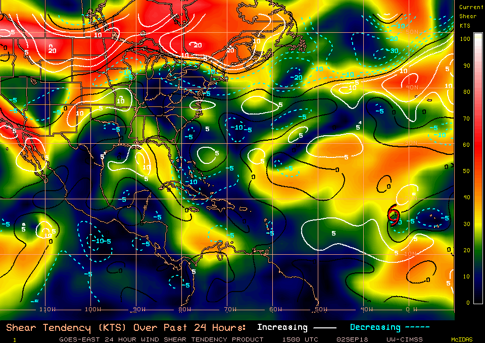
Just kidding of course, but I've been mentioning that the shear in the Eastern GoM continues to increase, albeit slowly. Some posters have mentioned that feature will move in tandem with the system, but so far it hasn't really budged. I'm a novice though, so I defer to others that know more.

Image

Image
0 likes   
Personal Forecast Disclaimer:
The posts in this forum are NOT official forecast and should not be used as such. They are just the opinion of the poster and may or may not be backed by sound meteorological data. They are NOT endorsed by any professional institution or storm2k.org. For official information, please refer to the NHC and NWS products.

Aric Dunn
Category 5
Category 5
Posts: 21238
Age: 42
Joined: Sun Sep 19, 2004 9:58 pm
Location: Ready for the Chase.
Contact:

Re: ATL: INVEST 91L - Discussion

#198 Postby Aric Dunn » Sun Sep 02, 2018 2:03 pm

tolakram wrote:Shear is not dropping in its path, if anything after this brief window of good conditions shear will continue to increase.


well, if you consider the fact the shear was not supposed to drop at all until the gulf and watching the progression of the shear over the past few days it has trended towards shifting west and weakening despite the models being persistent about it staying in place. technically the exact opposite has happened from what the models have been saying.. and the opposite if what the NHC has been saying until the 2pm outlook today..
so following this same progression then its logical to assume the shear axis will continue to shift west with it..
:)

you can easily see the shear axis over eastern florida at the start and is now moving off into the gulf.. pretty straight forward.

http://tropic.ssec.wisc.edu/real-time/a ... tjava.html
6 likes   
Note: If I make a post that is brief. Please refer back to previous posts for the analysis or reasoning. I do not re-write/qoute what my initial post said each time.
If there is nothing before... then just ask :)

Space & Atmospheric Physicist, Embry-Riddle Aeronautical University,
I believe the sky is falling...

User avatar
SoupBone
Category 5
Category 5
Posts: 3111
Joined: Tue Sep 20, 2005 5:24 pm

Re: ATL: INVEST 91L - Discussion

#199 Postby SoupBone » Sun Sep 02, 2018 2:05 pm

Aric Dunn wrote:
tolakram wrote:Shear is not dropping in its path, if anything after this brief window of good conditions shear will continue to increase.


well, if you consider the fact the shear was not supposed to drop at all until the gulf and watching the progression of the shear over the past few days it has trended towards shifting west and weakening despite the models being persistent about it staying in place. technically the exact opposite has happened from what the models have been saying.. and the opposite if what the NHC has been saying until the 2pm outlook today..
so following this same progression then its logical to assume the shear axis will continue to shift west with it..
:)

http://tropic.ssec.wisc.edu/real-time/a ... tjava.html


It has definitively shifted west some, but also expanded itself west as well. Look at the shear tendency loop over the last 24 hours or more. I don't disagree, but It has only degraded/shrunk on that eastern edge a little.
0 likes   
Personal Forecast Disclaimer:
The posts in this forum are NOT official forecast and should not be used as such. They are just the opinion of the poster and may or may not be backed by sound meteorological data. They are NOT endorsed by any professional institution or storm2k.org. For official information, please refer to the NHC and NWS products.

floridasun78
Category 5
Category 5
Posts: 3755
Joined: Sun May 17, 2009 10:16 pm
Location: miami fl

Re: ATL: INVEST 91L - Discussion

#200 Postby floridasun78 » Sun Sep 02, 2018 2:08 pm

i think their chance be a ts by south fl that very slimp- but their keeping eye on it miami weather office
0 likes   


Return to “2018”

Who is online

Users browsing this forum: No registered users and 5 guests