TPPN10 PGTW 300314
A. HURRICANE 25W (JEBI)
B. 30/0230Z
C. 17.48N
D. 148.70E
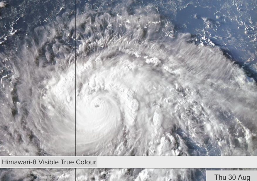
E. THREE/HMWRI8
F. T5.5/5.5/D2.0/24HRS STT: D0.5/03HRS
G. IR/EIR
H. REMARKS: 09A/PBO RAGGED EYE/ANMTN. LG EYE SURROUNDED BY B
YIELDS AN E# AND DT (NO EYE ADJUSTMENT) OF 5.5. MET AND PT
AGREE. DBO DT.
I. ADDITIONAL POSITIONS: NONE
LOWE
TXPQ29 KNES 300311
TCSWNP
A. 25W (JEBI)
B. 30/0230Z
C. 17.5N
D. 148.7E
E. ONE/HIMAWARI-8
F. T5.5/5.5/D1.0/24HRS
G. IR/EIR/VIS
H. REMARKS...THIS INTENSITY ESTIMATE WAS DERIVED USING 4 KM IR
DATA. MG EYE SURROUNDED AND EMBEDDED IN B RESULTS IN DT=5.5 AFTER 0.0
EYE ADJUSTMENT. MET AND PT AGREE. FT IS BASED ON DT.
I. ADDL POSITIONS
NIL
...BOLL
WPAC: JEBI - Post-Tropical
Moderator: S2k Moderators
Re: WPAC: JEBI - Typhoon
Recent microwave imagery shows that the western side of the eyewall remains relatively weak. Wouldn’t expect rapid intensification to continue in the near term.
0 likes
Personal Forecast Disclaimer:
The posts in this forum are NOT official forecast and should not be used as such. They are just the opinion of the poster and may or may not be backed by sound meteorological data. They are NOT endorsed by any professional institution or storm2k.org. For official information, please refer to RSMC and NWS products.
The posts in this forum are NOT official forecast and should not be used as such. They are just the opinion of the poster and may or may not be backed by sound meteorological data. They are NOT endorsed by any professional institution or storm2k.org. For official information, please refer to RSMC and NWS products.
-
mrbagyo

- Category 5

- Posts: 3963
- Age: 33
- Joined: Thu Apr 12, 2012 9:18 am
- Location: 14.13N 120.98E
- Contact:
Re: WPAC: JEBI - Typhoon
NotoSans wrote:Recent microwave imagery shows that the western side of the eyewall remains relatively weak. Wouldn’t expect rapid intensification to continue in the near term.
Yeah, that western side looks rather weak and ERC appears to be well underway.

0 likes
The posts in this forum are NOT official forecast and should not be used as such. They are just the opinion of the poster and may or may not be backed by sound meteorological data. They are NOT endorsed by any professional institution or storm2k.org. For official information, please refer to RSMC, NHC and NWS products.
-
mrbagyo
- Category 5
- Posts: 3963
- Age: 33
- Joined: Thu Apr 12, 2012 9:18 am
- Location: 14.13N 120.98E
- Contact:
Re: WPAC: JEBI - Typhoon
Now a major typhoon
25W JEBI 180830 0600 17.7N 148.1E WPAC 100 960
25W JEBI 180830 0600 17.7N 148.1E WPAC 100 960
0 likes
The posts in this forum are NOT official forecast and should not be used as such. They are just the opinion of the poster and may or may not be backed by sound meteorological data. They are NOT endorsed by any professional institution or storm2k.org. For official information, please refer to RSMC, NHC and NWS products.
-
Twisted-core
Re: WPAC: JEBI - Typhoon
https://s15.postimg.cc/tscl9r423/Selection_095.png
Magnificent looking fan on the outflow. Excellent conditions aloft obviously.
Magnificent looking fan on the outflow. Excellent conditions aloft obviously.
0 likes

-
euro6208
Re: WPAC: JEBI - Typhoon
Getting underestimated.
CURRENT ESTIMATE
Date (mmddhhmm): 08300556
SATCON: MSLP = 945 hPa MSW = 117 knots
SATCON Member Consensus: 113.0 knots
Pressure -> Wind Using SATCON MSLP: 113 knots
Distance to Outer Closed Isobar Used is 170 nm
Eye Size Correction Used is 5.2 knots Source: IR
Member Estimates
ADT: 959 hPa 100 knots Scene: CDO Date: AUG300740
CIMSS AMSU: 935 hPa 124 knots Bias Corr: 0 (MW) Date: 08300556
ATMS: 940.7 hPa 120.2 knots Date: 08300349
SSMIS: 940.7 hPa 120.2 knots Date: 08300349
CIRA ATMS: 974 hPa 74 knots Date: 08291550
0 likes
-
1900hurricane

- Category 5
- Posts: 6063
- Age: 34
- Joined: Fri Feb 06, 2015 12:04 pm
- Location: Houston, TX
- Contact:
Re: WPAC: JEBI - Typhoon
It may have resolved whatever issues were plaguing it (I suspect some mid-level dry air entrainment from the west based on the 00Z Guam sounding and satellite derived PW analysis). The CDO is cooling off and becoming more symmetrical, and the eye is warming up, now offering up a single point of warm medium grey.

0 likes
Contract Meteorologist. TAMU & MSST. Fiercely authentic, one of a kind. We are all given free will, so choose a life meant to be lived. We are the Masters of our own Stories.
Opinions expressed are mine alone.
Follow me on Twitter at @1900hurricane : Read blogs at https://1900hurricane.wordpress.com/
Opinions expressed are mine alone.
Follow me on Twitter at @1900hurricane : Read blogs at https://1900hurricane.wordpress.com/
-
mrbagyo
- Category 5
- Posts: 3963
- Age: 33
- Joined: Thu Apr 12, 2012 9:18 am
- Location: 14.13N 120.98E
- Contact:
Re: WPAC: JEBI - Typhoon
Currently at 85 knots
JMA is now expecting Jebi to become a Violent system
All Tropical Cyclones
TY 1821 (Jebi)
Issued at 09:45 UTC, 30 August 2018
<Analysis at 09 UTC, 30 August>
Scale -
Intensity Very strong
Center position N17°40' (17.7°)
E147°25' (147.4°)
Direction and speed of movement W 20 km/h (12 kt)
Central pressure 950 hPa
Maximum wind speed near center 45 m/s (85 kt)
Maximum wind gust speed 60 m/s (120 kt)
≥ 50 kt wind area ALL 70 km (40 NM)
≥ 30 kt wind area N 330 km (180 NM)
S 280 km (150 NM)
<Forecast for 21 UTC, 30 August>
Intensity Very strong
Center position of probability circle N17°55' (17.9°)
E145°00' (145.0°)
Direction and speed of movement W 20 km/h (11 kt)
Central pressure 940 hPa
Maximum wind speed near center 45 m/s (90 kt)
Maximum wind gust speed 65 m/s (130 kt)
Radius of probability circle 70 km (40 NM)
Storm warning area ALL 170 km (90 NM)
<Forecast for 09 UTC, 31 August>
Intensity Very strong
Center position of probability circle N18°35' (18.6°)
E142°35' (142.6°)
Direction and speed of movement WNW 20 km/h (12 kt)
Central pressure 935 hPa
Maximum wind speed near center 50 m/s (95 kt)
Maximum wind gust speed 70 m/s (135 kt)
Radius of probability circle 110 km (60 NM)
Storm warning area ALL 200 km (110 NM)
<Forecast for 06 UTC, 1 September>
Intensity Violent
Center position of probability circle N20°30' (20.5°)
E138°55' (138.9°)
Direction and speed of movement WNW 20 km/h (12 kt)
Central pressure 915 hPa
Maximum wind speed near center 55 m/s (105 kt)
Maximum wind gust speed 75 m/s (150 kt)
Radius of probability circle 200 km (110 NM)
Storm warning area ALL 330 km (180 NM)
<Forecast for 06 UTC, 2 September>
Intensity Violent
Center position of probability circle N23°35' (23.6°)
E135°55' (135.9°)
Direction and speed of movement NW 20 km/h (10 kt)
Central pressure 915 hPa
Maximum wind speed near center 55 m/s (105 kt)
Maximum wind gust speed 75 m/s (150 kt)
Radius of probability circle 240 km (130 NM)
Storm warning area ALL 370 km (200 NM)
1 likes
The posts in this forum are NOT official forecast and should not be used as such. They are just the opinion of the poster and may or may not be backed by sound meteorological data. They are NOT endorsed by any professional institution or storm2k.org. For official information, please refer to RSMC, NHC and NWS products.
-
Twisted-core

-
1900hurricane
- Category 5
- Posts: 6063
- Age: 34
- Joined: Fri Feb 06, 2015 12:04 pm
- Location: Houston, TX
- Contact:
Re: WPAC: JEBI - Typhoon
Twisted-core wrote:
just eyeballing i see a whats looks a entry level cat4.
That's in line with the latest SAB analysis.
TXPQ29 KNES 300903
TCSWNP
A. 25W (JEBI)
B. 30/0830Z
C. 17.8N
D. 147.5E
E. ONE/HIMAWARI-8
F. T6.0/6.0/D2.0/24HRS
G. IR/EIR/SWIR
H. REMARKS...THIS INTENSITY ESTIMATE WAS DERIVED USING 4 KM IR
DATA. OW EYE SURROUNDED AND EMBEDDED IN B YIELDS DT=6.0 AFTER +0.5 EYE
ADJUSTMENT. MET=5.0 AND PT=5.5. FT IS BASED ON DT.
I. ADDL POSITIONS
NIL
...BOLL
0 likes
Contract Meteorologist. TAMU & MSST. Fiercely authentic, one of a kind. We are all given free will, so choose a life meant to be lived. We are the Masters of our own Stories.
Opinions expressed are mine alone.
Follow me on Twitter at @1900hurricane : Read blogs at https://1900hurricane.wordpress.com/
Opinions expressed are mine alone.
Follow me on Twitter at @1900hurricane : Read blogs at https://1900hurricane.wordpress.com/
-
euro6208
Re: WPAC: JEBI - Typhoon
Unfortunately as the system gets stronger, it will continue to get underestimated big time. Nasty hit for the Northern Marianas.


000
WTPQ81 PGUM 301047
HLSPQ1
URGENT - IMMEDIATE BROADCAST REQUESTED
TYPHOON JEBI (25W) LOCAL STATEMENT
NATIONAL WEATHER SERVICE TIYAN GU
847 PM CHST THU AUG 30 2018
...TYPHOON JEBI CLOSING IN ON PAGAN...
.NEW INFORMATION...
NONE.
.AREAS AFFECTED...
THIS LOCAL STATEMENT PROVIDES INFORMATION AND RECOMMENDED ACTIONS FOR
PEOPLE ON AGRIHAN...PAGAN AND ALAMAGAN IN THE COMMONWEALTH OF THE
NORTHERN MARIANAS.
.WATCHES/WARNINGS...
A TYPHOON WARNING REMAINS IN EFFECT FOR AGRIHAN...PAGAN AND ALAMAGAN
IN THE COMMONWEALTH OF THE NORTHERN MARIANAS.
.STORM INFORMATION...
AT 700 PM CHST...THE CENTER OF TYPHOON JEBI WAS LOCATED NEAR LATITUDE
17.7 DEGREES NORTH AND LONGITUDE 147.5 DEGREES EAST. THIS IS ABOUT
105 MILES EAST OF ALAMAGAN...ABOUT 115 MILES EAST-SOUTHEAST OF PAGAN
AND 140 MILES EAST-SOUTHEAST OF AGRIHAN. STORM MOTION WAS TOWARD THE
WEST AT 14 MPH. STORM INTENSITY WAS 115 MPH WITH HIGHER GUSTS.
.SITUATION OVERVIEW...
JEBI WILL CONTINUE TO INTENSIFY THROUGH FRIDAY NIGHT. JEBI IS
CURRENTLY FORECAST TO TRACK THROUGH THE NORTHERN ISLANDS OF THE
COMMONWEALTH OF THE NORTHERN MARIANA ISLANDS AS A MAJOR TYPHOON. AN
EYE PASSAGE IS LIKELY FOR PAGAN ISLAND.
.NEXT UPDATE...
THE NEXT LOCAL STATEMENT WILL BE ISSUED BY THE NATIONAL WEATHER
SERVICE AT 300 AM FRIDAY MORNING...OR SOONER IF CONDITIONS WARRANT.
...PAGAN...
.PRECAUTIONARY/PREPAREDNESS ACTIONS...
DAMAGING WINDS ARE EITHER IMMINENT OR OCCURRING. REMAIN IN SHELTER
UNTIL WINDS HAVE FULLY SUBSIDED. DON`T VENTURE FAR FROM SHELTER
DURING EYE PASSAGE.
...WIND INFORMATION...
INCREASING NORTH WINDS WILL REACH DAMAGING LEVELS OF 40 MPH OR MORE
IN THE NEXT FEW HOURS. DAMAGING NORTH WINDS ARE EXPECTED TO INCREASE
FURTHER OVERNIGHT...REACHING TYPHOON-FORCE EARLY FRIDAY MORNING. THE
EYE COULD CROSS PAGAN WHERE VERY STRONG NORTH WINDS WOULD DIMINISH
SUDDENLY AND BECOME VERY LIGHT FOR A PERIOD OF MINUTES TO AN HOUR
FOLLOWED BY STRONG TYPHOON-FORCE WINDS FROM THE SOUTH. IF THE EYE
PASSES OVER...DO NOT MISTAKE THE EYE FOR THE END OF THE STORM.
DAMAGING WINDS WILL RESUME SUDDENLY...THIS TIME FROM THE SOUTH. WINDS
ARE EXPECTED TO SUBSIDE BELOW DAMAGING LEVELS LATE FRIDAY AFTERNOON
OR EVENING.
...STORM SURGE AND SURF INFORMATION...
COMBINED SEAS WILL INCREASE AS TYPHOON JEBI APPROACHES...AND COULD
REACH 30 OR EVEN 40 FEET NEAR THE CENTER OF JEBI. SURF COULD BUILD TO
HEIGHTS IN EXCESS OF 40 FEET WHICH COULD CAUSE COASTAL INUNDATION UP
TO 15 FEET.
...OTHER STORM EFFECTS...
RAINFALL ACCUMULATIONS OF 6 TO 12 INCHES ARE POSSIBLE THROUGH FRIDAY.
...AGRIHAN...
.PRECAUTIONARY/PREPAREDNESS ACTIONS...
DAMAGING WINDS ARE EITHER IMMINENT OR OCCURRING. REMAIN IN SHELTER
UNTIL WINDS HAVE FULLY SUBSIDED.
...WIND INFORMATION...
INCREASING NORTH WINDS WILL REACH DAMAGING LEVELS OF 40 MPH OR MORE
IN THE NEXT FEW HOURS. DAMAGING NORTH WINDS ARE EXPECTED TO INCREASE
FURTHER OVERNIGHT...AND WILL REACH NEAR TYPHOON FORCE EARLY FRIDAY
MORNING AS THEY GRADUALLY BECOME EAST THEN SOUTHEAST. WINDS WILL THEN
GRADUALLY DIMINISH LATER FRIDAY MORNING...AND ARE EXPECTED TO SUBSIDE
BELOW DAMAGING LEVELS LATE FRIDAY.
...STORM SURGE AND SURF INFORMATION...
COMBINED SEAS WILL INCREASE AS TYPHOON JEBI APPROACHES...AND COULD
REACH 25 OR EVEN 35 FEET NEAR THE CENTER OF JEBI. SURF COULD BUILD TO
HEIGHTS IN EXCESS OF 35 FEET WHICH COULD CAUSE COASTAL INUNDATION UP
TO 12 FEET.
...OTHER STORM EFFECTS...
RAINFALL ACCUMULATIONS OF 4 TO 8 INCHES ARE POSSIBLE THROUGH FRIDAY.
...ALAMAGAN...
.PRECAUTIONARY/PREPAREDNESS ACTIONS...
DAMAGING WINDS ARE EITHER IMMINENT OR OCCURRING. REMAIN IN SHELTER
UNTIL WINDS HAVE FULLY SUBSIDED.
...WIND INFORMATION...
INCREASING NORTH WINDS WILL REACH DAMAGING LEVELS OF 40 MPH OR MORE
IN THE NEXT FEW HOURS. DAMAGING NORTH WINDS ARE EXPECTED TO INCREASE
FURTHER OVERNIGHT...AND WILL REACH NEAR TYPHOON FORCE EARLY FRIDAY
MORNING AS THEY GRADUALLY BECOME NORTHWEST THEN EVENTUALLY WEST AND
SOUTHWEST. WINDS WILL THEN GRADUALLY DIMINISH LATER FRIDAY MORNING...
AND ARE EXPECTED TO SUBSIDE BELOW DAMAGING LEVELS LATE FRIDAY AS THEY
BECOME SOUTHEAST.
...STORM SURGE AND SURF INFORMATION...
COMBINED SEAS OF 20 TO 30 FEET ARE EXPECTED SLIGHTLY FARTHER FROM
THE CENTER OF JEBI. SURF COULD REACH 36 FEET WHICH COULD CAUSE
COASTAL INUNDATION UP TO 12 FEET.
...OTHER STORM EFFECTS...
RAINFALL ACCUMULATIONS OF 6 TO 12 INCHES ARE POSSIBLE.
$$
STANKO
0 likes
Re: WPAC: JEBI - Typhoon
The SATCON estimate is likely distorted by the AMSU estimate. The AMSU estimate depends heavily on the estimated RMW due to resolution problem. The latest AMSU used an estimated RMW of 9 km, which is likely too small and leads to higher intensity estimates.
0 likes
Personal Forecast Disclaimer:
The posts in this forum are NOT official forecast and should not be used as such. They are just the opinion of the poster and may or may not be backed by sound meteorological data. They are NOT endorsed by any professional institution or storm2k.org. For official information, please refer to RSMC and NWS products.
The posts in this forum are NOT official forecast and should not be used as such. They are just the opinion of the poster and may or may not be backed by sound meteorological data. They are NOT endorsed by any professional institution or storm2k.org. For official information, please refer to RSMC and NWS products.
-
mrbagyo
- Category 5
- Posts: 3963
- Age: 33
- Joined: Thu Apr 12, 2012 9:18 am
- Location: 14.13N 120.98E
- Contact:
Re: WPAC: JEBI - Typhoon
Is there any observation station in Pagan Island, they have an airstrip there but I can't find any METAR. 
1 likes
The posts in this forum are NOT official forecast and should not be used as such. They are just the opinion of the poster and may or may not be backed by sound meteorological data. They are NOT endorsed by any professional institution or storm2k.org. For official information, please refer to RSMC, NHC and NWS products.
-
euro6208
Re: WPAC: JEBI - Typhoon
WOW
TPPN10 PGTW 301218
A. TYPHOON 25W (JEBI)
B. 30/1150Z
C. 17.77N
D. 146.86E
E. ONE/HMWRI8
F. T6.5/6.5/D2.5/24HRS STT: D1.0/03HRS
G. IR/EIR
H. REMARKS: 01A/PBO EYE/ANMTN. WMG EYE SURROUNDED BY B YIELDS
AN E# OF 5.5. ADDED 1.0 FOR EYE ADJUSTMENT TO YIELD A DT OF
6.5. MET AND PT AGREE. DBO DT.
I. ADDITIONAL POSITIONS: NONE
VEERKAMP
0 likes

-
xtyphooncyclonex

- Category 5
- Posts: 3891
- Age: 24
- Joined: Sat Dec 08, 2012 9:07 am
- Location: Cebu City
- Contact:
Re: WPAC: JEBI - Typhoon
well
25W JEBI 180830 1200 17.7N 146.8E WPAC 110 952
25W JEBI 180830 1200 17.7N 146.8E WPAC 110 952
0 likes
REMINDER: My opinions that I, or any other NON Pro-Met in this forum, are unofficial. Please do not take my opinions as an official forecast and warning. I am NOT a meteorologist. Following my forecasts blindly may lead to false alarm, danger and risk if official forecasts from agencies are ignored.
-
euro6208
Re: WPAC: JEBI - Typhoon
xtyphooncyclonex wrote:well
25W JEBI 180830 1200 17.7N 146.8E WPAC 110 952
 Catching up...
0 likes
-
mrbagyo
- Category 5
- Posts: 3963
- Age: 33
- Joined: Thu Apr 12, 2012 9:18 am
- Location: 14.13N 120.98E
- Contact:
Re: WPAC: JEBI - Typhoon
I'd give this at least 115 .
0 likes
The posts in this forum are NOT official forecast and should not be used as such. They are just the opinion of the poster and may or may not be backed by sound meteorological data. They are NOT endorsed by any professional institution or storm2k.org. For official information, please refer to RSMC, NHC and NWS products.
-
xtyphooncyclonex
- Category 5
- Posts: 3891
- Age: 24
- Joined: Sat Dec 08, 2012 9:07 am
- Location: Cebu City
- Contact:
Re: WPAC: JEBI - Typhoon
euro6208 wrote:xtyphooncyclonex wrote:well
25W JEBI 180830 1200 17.7N 146.8E WPAC 110 952
I guess we're waiting for JMA's advisory. I guess they would go with T6.0 (about 90-95kts, 935-940 hPa)
0 likes
REMINDER: My opinions that I, or any other NON Pro-Met in this forum, are unofficial. Please do not take my opinions as an official forecast and warning. I am NOT a meteorologist. Following my forecasts blindly may lead to false alarm, danger and risk if official forecasts from agencies are ignored.
Who is online
Users browsing this forum: No registered users and 82 guests