WPAC: BEBINCA - Post-Tropical
Moderator: S2k Moderators
Re: WPAC: INVEST 96W
TCFA reissued...
WTPN21 PGTW 120530
MSGID/GENADMIN/JOINT TYPHOON WRNCEN PEARL HARBOR HI//
SUBJ/TROPICAL CYCLONE FORMATION ALERT//
RMKS/
1. FORMATION OF A SIGNIFICANT TROPICAL CYCLONE IS POSSIBLE WITHIN
A 160 NM RADIUS OF 21.0N 111.9E WITHIN THE NEXT 06 TO 24 HOURS.
AVAILABLE DATA DOES NOT JUSTIFY ISSUANCE OF NUMBERED TROPICAL
CYCLONE WARNINGS AT THIS TIME. WINDS IN THE AREA ARE ESTIMATED TO
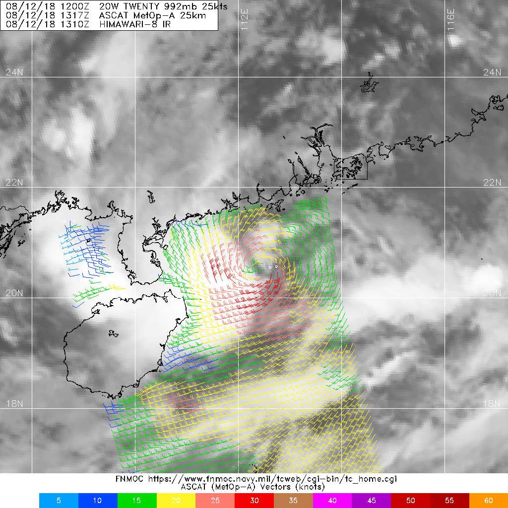
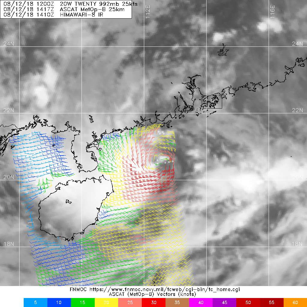
BE 20 TO 25 KNOTS. METSAT IMAGERY AT 120500Z INDICATES THAT A
CIRCULATION CENTER IS LOCATED NEAR 21.0N 111.9E. THE SYSTEM IS
MOVING EAST-SOUTHEASTWARD AT 08 KNOTS.
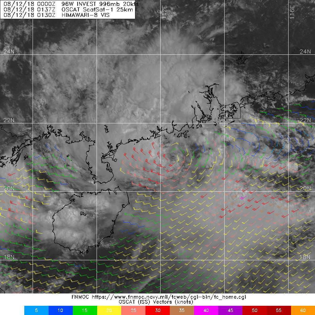
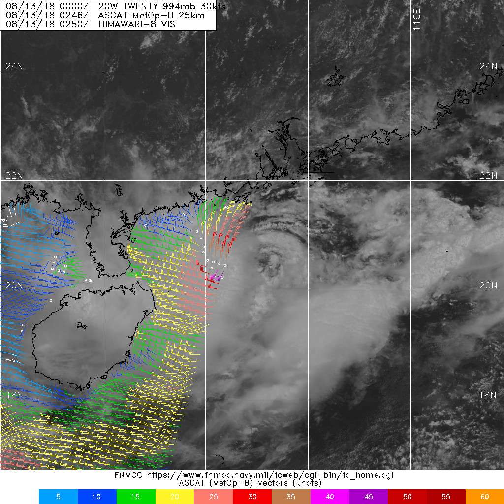
2. REMARKS: THE AREA OF CONVECTION (INVEST 96W) PREVIOUSLY LOCATED
NEAR 21.8N 111.1E IS NOW LOCATED NEAR 21.0N 111.9E, APPROXIMATELY
164NM WEST-SOUTHWEST OF HONG KONG. ANIMATED MULTISPECTRAL SATELLITE
IMAGERY DEPICTS A PARTIALLY-EXPOSED LOW LEVEL CIRCULATION CENTER
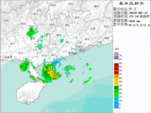
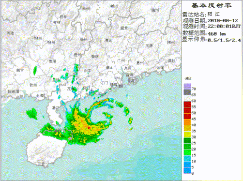
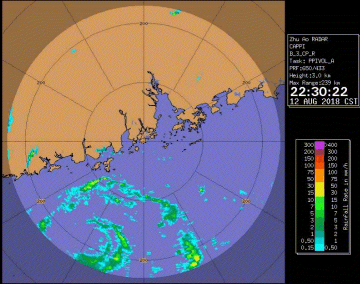
(LLCC) WITH FLARING CONVECTION DISPLACED TO THE WEST. ANIMATED RADAR
IMAGERY INDICATES MULTIPLE LOW-LEVEL RAIN BANDS WRAPPING TIGHTLY
INTO A DEFINED LLCC OVER WATER. A 120205Z MHS METOP-A 89GHZ IMAGE
SHOWS WEAK DEEP CONVECTIVE BANDING WRAPPING INTO THE LLCC. SURFACE
OBSERVATIONS ALONG THE COAST (YANGJIANG AND SHANGCHUAN DAO) INDICATE
NORTHEASTERLY WINDS AT 15 TO 20 KNOTS AND SLP NEAR 994MB. THE UPPER-
LEVEL ENVIRONMENT IS FAVORABLE FOR DEVELOPMENT WITH GOOD DIVERGENCE
ALOFT AND MODERATE VERTICAL WIND SHEAR (10-20 KTS) WITH STRONG
VERTICAL WIND SHEAR TO THE SOUTH. SEA SURFACE TEMPERATURES REMAIN
WARM (28-29C) IN THE SOUTH CHINA SEA. GLOBAL MODELS DEPICT THE
SYSTEM REMAINING QUASI-STATIONARY OVER THE NEXT 48 HOURS WITH SLOW
DEVELOPMENT DUE TO THE INTERACTION WITH LAND. ONCE DEVELOPMENT
OCCURS, THE MODELS DIFFER ON THE EXACT TRACK OF THE SYSTEM. MAXIMUM
SUSTAINED SURFACE WINDS ARE ESTIMATED AT 20 TO 25 KNOTS. MINIMUM SEA
LEVEL PRESSURE IS ESTIMATED TO BE NEAR 994 MB. THE POTENTIAL FOR THE
DEVELOPMENT OF A SIGNIFICANT TROPICAL CYCLONE WITHIN THE NEXT 24
HOURS IS HIGH.
3. THIS ALERT WILL BE REISSUED, UPGRADED TO WARNING OR CANCELLED BY
130530Z.//
NNNN
0 likes
Remember, all of my post aren't official. For official warnings and discussions, Please refer to your local NWS products...
NWS for the Western Pacific
https://www.weather.gov/gum/
NWS for the Western Pacific
https://www.weather.gov/gum/
Re: WPAC: INVEST 96W
TPPN12 PGTW 120626
A. TROPICAL DISTURBANCE 96W (NE OF HAINAN)
B. 12/0600Z
C. 21.13N
D. 112.35E
E. FIVE/HMWRI8
F. T1.0/1.0
G. IR/EIR/VIS/MSI
H. REMARKS: 49A/PBO PTLY XPSD LLCC/ANMTN. CNVCTN WRAPS .20 ON
LOG10 SPIRAL YIELDING A DT OF 1.0. MET AND PT AGREE. DBO DT.
I. ADDITIONAL POSITIONS: NONE
VEERKAMP
A. TROPICAL DISTURBANCE 96W (NE OF HAINAN)
B. 12/0600Z
C. 21.13N
D. 112.35E
E. FIVE/HMWRI8
F. T1.0/1.0
G. IR/EIR/VIS/MSI
H. REMARKS: 49A/PBO PTLY XPSD LLCC/ANMTN. CNVCTN WRAPS .20 ON
LOG10 SPIRAL YIELDING A DT OF 1.0. MET AND PT AGREE. DBO DT.
I. ADDITIONAL POSITIONS: NONE
VEERKAMP
0 likes
Remember, all of my post aren't official. For official warnings and discussions, Please refer to your local NWS products...
NWS for the Western Pacific
https://www.weather.gov/gum/
NWS for the Western Pacific
https://www.weather.gov/gum/
Re: WPAC: INVEST 96W
TXPQ22 KNES 120403
TCSWNP
CCA
A. TROPICAL DISTURBANCE (96W)
B. 12/0230Z
C. 21.1N
D. 112.3E
E. FIVE/HIMAWARI-8
F. T1.0/1.0
G. IR/EIR/VIS
H. REMARKS...COR FOR MET AND PT. THIS INTENSITY ESTIMATE WAS DERIVED
USING 4 KM IR DATA. DT OF 1.0 IS BASED ON GT 0.2 BANDING IN VIS. MET
AND PT ARE UNAVAILBLE AS SYSTEM WAS INLAND (AS OPPOSED TO TWTC) 24HRS
AGO. FT IS BASED ON DT.
I. ADDL POSITIONS
NIL
...RAMIREZ
0 likes
Remember, all of my post aren't official. For official warnings and discussions, Please refer to your local NWS products...
NWS for the Western Pacific
https://www.weather.gov/gum/
NWS for the Western Pacific
https://www.weather.gov/gum/
Re: WPAC: INVEST 96W
TPPN12 PGTW 120853
A. TROPICAL DISTURBANCE 96W (NE OF HAINAN)
B. 12/0600Z
C. 20.87N
D. 112.27E
E. FIVE/HMWRI8
F. T1.0/1.0
G. IR/EIR/VIS/MSI
H. REMARKS: 49A/PBO PTLY XPSD LLCC/ANMTN. CNVCTN WRAPS .25 ON
LOG10 SPIRAL YIELDING A DT OF 1.0. MET AND PT AGREE. DBO DT.
I. ADDITIONAL POSITIONS: NONE
VEERKAMP
A. TROPICAL DISTURBANCE 96W (NE OF HAINAN)
B. 12/0600Z
C. 20.87N
D. 112.27E
E. FIVE/HMWRI8
F. T1.0/1.0
G. IR/EIR/VIS/MSI
H. REMARKS: 49A/PBO PTLY XPSD LLCC/ANMTN. CNVCTN WRAPS .25 ON
LOG10 SPIRAL YIELDING A DT OF 1.0. MET AND PT AGREE. DBO DT.
I. ADDITIONAL POSITIONS: NONE
VEERKAMP
0 likes
Remember, all of my post aren't official. For official warnings and discussions, Please refer to your local NWS products...
NWS for the Western Pacific
https://www.weather.gov/gum/
NWS for the Western Pacific
https://www.weather.gov/gum/
Re: WPAC: INVEST 96W
TXPQ22 KNES 120953
TCSWNP
A. TROPICAL DISTURBANCE (96W)
B. 12/0830Z
C. 21.0N
D. 112.3E
E. THREE/HIMAWARI-8
F. T1.0/1.0/S0.0/12HRS
G. IR/EIR/VIS
H. REMARKS...THIS INTENSITY ESTIMATE WAS DERIVED USING 4 KM IR DATA. DT
OF 1.0 IS BASED ON GT 0.2 CURVED BANDING. MET AND PT ARE 1.0. FT IS
BASED ON DT.
I. ADDL POSITIONS
NIL
...RAMIREZ
0 likes
Remember, all of my post aren't official. For official warnings and discussions, Please refer to your local NWS products...
NWS for the Western Pacific
https://www.weather.gov/gum/
NWS for the Western Pacific
https://www.weather.gov/gum/
Re: WPAC: INVEST 96W
0 likes
Remember, all of my post aren't official. For official warnings and discussions, Please refer to your local NWS products...
NWS for the Western Pacific
https://www.weather.gov/gum/
NWS for the Western Pacific
https://www.weather.gov/gum/
- mrbagyo
- Category 5
- Posts: 3617
- Age: 32
- Joined: Thu Apr 12, 2012 9:18 am
- Location: 14.13N 120.98E
- Contact:
Re: WPAC: INVEST 96W
12 hr old OSCAT pass showed 30 knots
Latest radar loop
Latest radar loop
0 likes
The posts in this forum are NOT official forecast and should not be used as such. They are just the opinion of the poster and may or may not be backed by sound meteorological data. They are NOT endorsed by any professional institution or storm2k.org. For official information, please refer to RSMC, NHC and NWS products.
- 1900hurricane
- Category 5
- Posts: 6044
- Age: 33
- Joined: Fri Feb 06, 2015 12:04 pm
- Location: Houston, TX
- Contact:
Re: WPAC: INVEST 96W
This one probably needs classification now (although JMA is already calling it a TD).
0 likes
Contract Meteorologist. TAMU & MSST. Fiercely authentic, one of a kind. We are all given free will, so choose a life meant to be lived. We are the Masters of our own Stories.
Opinions expressed are mine alone.
Follow me on Twitter at @1900hurricane : Read blogs at https://1900hurricane.wordpress.com/
Opinions expressed are mine alone.
Follow me on Twitter at @1900hurricane : Read blogs at https://1900hurricane.wordpress.com/
- mrbagyo
- Category 5
- Posts: 3617
- Age: 32
- Joined: Thu Apr 12, 2012 9:18 am
- Location: 14.13N 120.98E
- Contact:
Re: WPAC: INVEST 96W
TYPHOON:Signal No.3 is still in effect. At 21 L.T.,T.S. is located about 210 km southwest of Macao and moves toward the western coast of Guangdong province. The signal No.3 will remain in effect at night. As the winds over the bridges are expected to be strong and gusty, drivers are advised to pay attention to traffic safety. Motorcyclists should travel between Macao Peninsula and Taipa Island through motorcycle lane on Sai Van Bridge.
STORMSURGE:Blue storm surge warning is still in force
Macao Radar
STORMSURGE:Blue storm surge warning is still in force
Macao Radar
0 likes
The posts in this forum are NOT official forecast and should not be used as such. They are just the opinion of the poster and may or may not be backed by sound meteorological data. They are NOT endorsed by any professional institution or storm2k.org. For official information, please refer to RSMC, NHC and NWS products.
- mrbagyo
- Category 5
- Posts: 3617
- Age: 32
- Joined: Thu Apr 12, 2012 9:18 am
- Location: 14.13N 120.98E
- Contact:
Re: WPAC: INVEST 96W
TD 20W
20W INVEST 180812 1200 20.8N 112.3E WPAC 25 992
0 likes
The posts in this forum are NOT official forecast and should not be used as such. They are just the opinion of the poster and may or may not be backed by sound meteorological data. They are NOT endorsed by any professional institution or storm2k.org. For official information, please refer to RSMC, NHC and NWS products.
- mrbagyo
- Category 5
- Posts: 3617
- Age: 32
- Joined: Thu Apr 12, 2012 9:18 am
- Location: 14.13N 120.98E
- Contact:
Re: WPAC: INVEST 96W
Must be a tropical storm by now ( 1 min) - maybe in the next advisory by JTWC
0 likes
The posts in this forum are NOT official forecast and should not be used as such. They are just the opinion of the poster and may or may not be backed by sound meteorological data. They are NOT endorsed by any professional institution or storm2k.org. For official information, please refer to RSMC, NHC and NWS products.
- mrbagyo
- Category 5
- Posts: 3617
- Age: 32
- Joined: Thu Apr 12, 2012 9:18 am
- Location: 14.13N 120.98E
- Contact:
Re: WPAC: INVEST 96W
Radar signature continues to improve
0 likes
The posts in this forum are NOT official forecast and should not be used as such. They are just the opinion of the poster and may or may not be backed by sound meteorological data. They are NOT endorsed by any professional institution or storm2k.org. For official information, please refer to RSMC, NHC and NWS products.
Re: WPAC: INVEST 96W
WDPN33 PGTW 122100
MSGID/GENADMIN/JOINT TYPHOON WRNCEN PEARL HARBOR HI//
SUBJ/PROGNOSTIC REASONING FOR TROPICAL DEPRESSION 20W (TWENTY)
WARNING NR 02//
RMKS//
1. FOR METEOROLOGISTS.
2. 6 HOUR SUMMARY AND ANALYSIS.
TROPICAL DEPRESSION (TD) 20W (TWENTY), LOCATED APPROXIMATELY 139
NM SOUTHWEST OF HONG KONG, HAS TRACKED SOUTHEASTWARD AT 03 KNOTS OVER
THE PAST SIX HOURS. ANIMATED EIR SATELLITE IMAGERY SHOWS A
PARTIALLY-EXPOSED LLC WITH AN AREA OF PERSISTENT FLARING CONVECTION
SHEARED TO THE WESTERN SEMICIRCLE. THE INITIAL POSITION IS PLACED
WITH FAIR CONFIDENCE BASED ON THE EIR LOOP AND IS SUPPORTED BY NEARBY
SURFACE OBSERVATIONS. THE INITIAL INTENSITY OF 25 KNOTS IS BASED ON
DVORAK INTENSITY ESTIMATES OF T1.5 FROM PGTW, KNES, AND RJTD.
UPPER-LEVEL ANALYSIS INDICATES A MARGINAL ENVIRONMENT WITH MODERATE
TO STRONG (15 TO 30 KNOT) VWS SLIGHTLY OFFSET BY A WEAK POLEWARD
OUTFLOW. TD 20W IS IN A WEAK STEERING ENVIRONMENT: IT IS EMBEDDED
BETWEEN THE SOUTHWEST MONSOON FLOW AND THE LOW- TO MID-LEVEL
REFLECTION OF THE STR TO THE NORTHEAST. AS A RESULT, STORM MOTION IS
QUASI-STATIONARY (QS).
3. FORECAST REASONING.
A. THERE IS NO CHANGE TO THE FORECAST PHILOSOPHY FROM THE PREVIOUS
PROGNOSTIC REASONING MESSAGE.
B. TD 20W IS EXPECTED TO REMAIN QS AT LEAST UP TO TAU 24.
AFTERWARD, AS THE TD DEEPENS INTO A TS, THE BUILDING STR WILL BECOME
THE PRIMARY STEERING MECHANISM AND DRIVE THE SYSTEM GENERALLY
WEST-NORTHWESTWARD BACK TOWARD THE CHINA COAST. ENHANCED BY THE
AFOREMENTIONED MARGINAL ENVIRONMENT, TD 20W SHOULD INTENSIFY SLIGHTLY
OVER THE NEXT 36 HOURS TO A PEAK OF 35 KNOTS. AFTERWARD, THE SYSTEM
SHOULD WEAKEN AS IT APPROACHES THEN TRACKS OVER LAND, LEADING TO
DISSIPATION BY TAU 72. OVERALL, THERE IS LOW CONFIDENCE IN THE JTWC
FORECAST TRACK DUE TO THE WEAK STEERING ENVIRONMENT AND THE RESULTING
QS STORM MOTION AND THE LARGE SPREAD IN NUMERICAL MODEL SOLUTIONS.//
NNNN
0 likes
Remember, all of my post aren't official. For official warnings and discussions, Please refer to your local NWS products...
NWS for the Western Pacific
https://www.weather.gov/gum/
NWS for the Western Pacific
https://www.weather.gov/gum/
Re: WPAC: INVEST 96W
0 likes
Remember, all of my post aren't official. For official warnings and discussions, Please refer to your local NWS products...
NWS for the Western Pacific
https://www.weather.gov/gum/
NWS for the Western Pacific
https://www.weather.gov/gum/
- mrbagyo
- Category 5
- Posts: 3617
- Age: 32
- Joined: Thu Apr 12, 2012 9:18 am
- Location: 14.13N 120.98E
- Contact:
Re: WPAC: Tropical Depression 96W
20W TWENTY 180813 0000 20.7N 112.9E WPAC 30 994
0 likes
The posts in this forum are NOT official forecast and should not be used as such. They are just the opinion of the poster and may or may not be backed by sound meteorological data. They are NOT endorsed by any professional institution or storm2k.org. For official information, please refer to RSMC, NHC and NWS products.
- mrbagyo
- Category 5
- Posts: 3617
- Age: 32
- Joined: Thu Apr 12, 2012 9:18 am
- Location: 14.13N 120.98E
- Contact:
Re: WPAC: Tropical Depression 96W
Alyono wrote:officially a tropical storm named Bebinca
That sounds delicious.
1 likes
The posts in this forum are NOT official forecast and should not be used as such. They are just the opinion of the poster and may or may not be backed by sound meteorological data. They are NOT endorsed by any professional institution or storm2k.org. For official information, please refer to RSMC, NHC and NWS products.
- cycloneye
- Admin
- Posts: 139719
- Age: 67
- Joined: Thu Oct 10, 2002 10:54 am
- Location: San Juan, Puerto Rico
Re: WPAC: BEBINCA - Tropical Storm
TS 1816 (Bebinca)
Issued at 01:25 UTC, 13 August 2018
<Analysis at 00 UTC, 13 August>
Scale -
Intensity -
Center position N20°35' (20.6°)
E112°50' (112.8°)
Direction and speed of movement Almost stationary
Central pressure 992 hPa
Maximum wind speed near center 18 m/s (35 kt)
Maximum wind gust speed 25 m/s (50 kt)
≥ 30 kt wind area S 220 km (120 NM)
N 110 km (60 NM)
<Forecast for 00 UTC, 14 August>
Intensity -
Center position of probability circle N20°40' (20.7°)
E113°05' (113.1°)
Direction and speed of movement Almost stationary
Central pressure 985 hPa
Maximum wind speed near center 20 m/s (40 kt)
Maximum wind gust speed 30 m/s (60 kt)
Radius of probability circle 110 km (60 NM)
<Forecast for 00 UTC, 15 August>
Intensity -
Center position of probability circle N21°20' (21.3°)
E111°25' (111.4°)
Direction and speed of movement WNW Slow
Central pressure 990 hPa
Maximum wind speed near center 18 m/s (35 kt)
Maximum wind gust speed 25 m/s (50 kt)
Radius of probability circle 180 km (95 NM)
<Forecast for 00 UTC, 16 August>
Intensity -
Center position of probability circle N21°00' (21.0°)
E108°30' (108.5°)
Direction and speed of movement W 15 km/h (7 kt)
Central pressure 990 hPa
Maximum wind speed near center 18 m/s (35 kt)
Maximum wind gust speed 25 m/s (50 kt)
Radius of probability circle 240 km (130 NM)
0 likes
Visit the Caribbean-Central America Weather Thread where you can find at first post web cams,radars
and observations from Caribbean basin members Click Here
- mrbagyo
- Category 5
- Posts: 3617
- Age: 32
- Joined: Thu Apr 12, 2012 9:18 am
- Location: 14.13N 120.98E
- Contact:
Re: WPAC: BEBINCA - Tropical Storm
0 likes
The posts in this forum are NOT official forecast and should not be used as such. They are just the opinion of the poster and may or may not be backed by sound meteorological data. They are NOT endorsed by any professional institution or storm2k.org. For official information, please refer to RSMC, NHC and NWS products.
Re: WPAC: BEBINCA - Tropical Storm
WDPN33 PGTW 130900
MSGID/GENADMIN/JOINT TYPHOON WRNCEN PEARL HARBOR HI//
SUBJ/PROGNOSTIC REASONING FOR TROPICAL STORM 20W (BEBINCA)
WARNING NR 04//
RMKS//
1. FOR METEOROLOGISTS.
2. 6 HOUR SUMMARY AND ANALYSIS.
TROPICAL STORM (TS) 20W (BEBINCA), LOCATED APPROXIMATELY 116 NM
SOUTH-SOUTHWEST OF HONG KONG, HAS TRACKED EASTWARD AT 03 KNOTS OVER
THE PAST SIX HOURS. ANIMATED MULTISPECTRAL SATELLITE IMAGERY DEPICTS
AN EXPOSED, COMPACT LOW-LEVEL CIRCULATION CENTER (LLCC) WITH FLARING
DEEP CONVECTION DISPLACED OVER THE WESTERN SEMICIRCLE OF THE LLCC
DUE TO MODERATE TO STRONG (25 TO 35 KNOTS) EASTERLY VERTICAL WIND
SHEAR (VWS). A 130702Z SSMI 85GHZ IMAGE REVEALS A WELL-DEFINED LLCC
WITH WEAKLY-CURVED DEEP CONVECTIVE BANDING OVER THE WEST QUADRANT. A
130144Z ASCAT IMAGE INDICATES 30-35 KNOT WINDS OVER THE SOUTHERN
SEMICIRCLE, WHICH SUPPORTS THE INITIAL INTENSITY OF 35 KNOTS. DVORAK
INTENSITY ESTIMATES ALSO SUPPORT THE UPGRADE TO TS AND RANGE FROM
T2.0-2.5 (30-35 KNOTS). TS 20W REMAINS EMBEDDED WITHIN A WEAK
STEERING ENVIRONMENT WITH THE SUBTROPICAL RIDGE (STR) DISPLACED WELL
TO THE NORTH AND EAST DUE TO THE PRESENCE OF A LARGE LOW PRESSURE
AREA ASSOCIATED WITH TS 20W, THE REMNANTS OF TROPICAL DEPRESSION 18W
AND INVEST 98W. AS A RESULT THE SYSTEM HAS DRIFTED SLOWLY EASTWARD
OVER THE PAST 18 HOURS.
3. FORECAST REASONING.
A. THERE IS NO CHANGE TO THE FORECAST PHILOSOPHY FROM THE PREVIOUS
PROGNOSTIC REASONING MESSAGE.
B. TS 20W IS FORECASTED TO REMAIN QUASI-STATIONARY THROUGH TAU 36
UNDER A WEAK STEERING INFLUENCE. AFTER TAU 36, THE STR IS EXPECTED
TO STRENGTHEN TO THE NORTH AS 18W DECAYS OVER LAND. THIS WILL
ALLOW TS 20W TO ACCELERATE WESTWARD. TS 20W WILL REMAIN WITHIN A
MARGINAL UPPER-LEVEL ENVIRONMENT WITH MODERATE TO STRONG VWS,
THEREFORE, THE SYSTEM IS EXPECTED TO MAINTAIN INTENSITY AT 30-35
KNOTS THROUGH TAU 36. FROM TAU 48 TO TAU 72, TS 20W SHOULD WEAKEN
SLIGHTLY DUE TO INCREASED INTERACTION WITH LAND AS WELL AS
PERSISTENT VWS.
C. AFTER TAU 72, SLIGHT RE-INTENSIFICATION IS ANTICIPATED OVER
THE GULF OF TONKIN DUE TO THE WARM SST AND FAVORABLE OCEAN HEAT
CONTENT, TEMPERED BY PERSISTENT MARGINAL UPPER-LEVEL CONDITIONS. THE
SYSTEM SHOULD ACCELERATE WESTWARD AND WILL MAKE LANDFALL NEAR TAU 96
ALONG THE NORTHEAST COAST OF VIETNAM WITH DISSIPATION EXPECTED BY
TAU 120. OVERALL, THERE IS LOW CONFIDENCE IN THE JTWC FORECAST TRACK
DUE TO THE WEAK STEERING ENVIRONMENT AND QUASI-STATIONARY TRACK
MOTION THROUGH TAU 36, AND THE HIGH DEGREE OF UNCERTAINTY THROUGHOUT
THE FORECAST PERIOD WITH A LARGE SPREAD IN MODEL SOLUTIONS.//
NNNN
0 likes
Remember, all of my post aren't official. For official warnings and discussions, Please refer to your local NWS products...
NWS for the Western Pacific
https://www.weather.gov/gum/
NWS for the Western Pacific
https://www.weather.gov/gum/
Who is online
Users browsing this forum: No registered users and 3 guests