Hurricane Hector Discussion Number 49
NWS Central Pacific Hurricane Center Honolulu HI EP102018
500 AM HST Sun Aug 12 2018
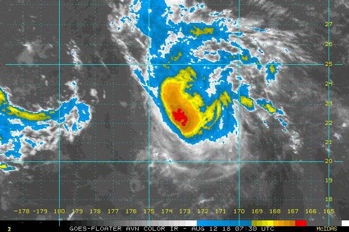
Hector continues to rapidly weaken this morning due to 20 to 30
knots of south-southwesterly shear over the system as analyzed by
the latest UW-CIMSS shear analysis. The low level circulation
center remains difficult to locate, but a couple overnight microwave
passes and an ASCAT pass were helpful in determining the center
location. The latest subjective Dvorak intensity estimates were 4.5
(77 knots) from PHFO, 4.0 (65 knots) from SAB, and 3.5 (55 knots)
from JTWC. Meanwhile, the Advanced Dvorak Technique from UW-CIMSS
was 4.4 (75 knots). The satellite presentation clearly shows that
weakening is ongoing, but given the persistent deep convection over
the low level circulation center and necessary spin down time needed
as these systems weaken, will only lower the initial intensity to 75
knots with this advisory which is on the higher side of the
intensity estimates. The initial motion is set at 305/14 knots.
The latest model guidance remains tightly clustered through 96
hours, with the spread in the track guidance increasing
considerably by 120 hours. Hector is expected to continue on a
northwest track today on the eastern periphery of an upper level low
to the west of the International Date Line. The system is expected
to make a turn to a more westerly direction tonight and continue on
this course through Wednesday as an upper level ridge builds north
of the system. A turn toward the northwest and eventually north is
then expected Wednesday night through Friday as Hector rounds the
southwest periphery of the upper level ridge. The new official
forecast track is very close to the consensus guidance as well as
the track from the previous advisory.
The intensity forecast calls for steady weakening of Hector over
the next 12 to 24 hours as the system will be in a hostile
environment under 15 to 30 knots of southwesterly shear. The shear
is forecast to decrease beyond 24 hours, but the system will likely
have weakened considerably by this time and will be moving over
marginal sea surface temperatures between 79 and 81 degrees
Fahrenheit. The intensity guidance is in fairly good agreement
through 36 hours, so confidence during this portion of the forecast
is fairly good. There is quite a bit of spread in the intensity
guidance beyond 36 hours however, with the HWRF and CTCI models
continuing to show Hector re-intensifying into a hurricane by 48
hours and holding at hurricane strength through 120 hours. This
seems really aggressive given the state the hurricane is in at the
moment and with the continued weakening forecast. As a result, the
official intensity forecast calls for steady weakening through
tonight, with Hector becoming a Tropical Storm later today or
tonight. Beyond 24 hours the forecast intensity has been held
steady, with weakening expected at the end of the forecast period as
Hector transitions over to an extratropical system.
Probabilities for tropical storm force winds reaching the
Northwestern Hawaiian Islands have decreased since the previous
advisory. If Hector continues to weaken as expected, and the
forecast track of a northwest to west-northwest motion holds true,
the Tropical Storm Watches currently in effect from Lisianski
Island to Pearl and Hermes Atoll, as well as for Midway and Kure
Atolls, may be cancelled later today.
FORECAST POSITIONS AND MAX WINDS
INIT 12/1500Z 22.8N 174.2W 75 KT 85 MPH
12H 13/0000Z 24.0N 176.2W 65 KT 75 MPH
24H 13/1200Z 25.3N 179.0W 55 KT 65 MPH
36H 14/0000Z 26.3N 178.0E 55 KT 65 MPH
48H 14/1200Z 27.2N 174.9E 55 KT 65 MPH
72H 15/1200Z 29.3N 168.4E 55 KT 65 MPH
96H 16/1200Z 32.1N 163.4E 55 KT 65 MPH
120H 17/1200Z 36.1N 161.3E 45 KT 50 MPH...POST-TROP/EXTRATROP
$$
Forecaster Jelsema
Visit the Caribbean-Central America Weather Thread where you can find at first post web cams,radars
and observations from Caribbean basin members
Click Here


The great Hawaiian Shear Belt is real.