WPAC: HECTOR - Post-Tropical

Moderator: S2k Moderators

Message
Author
User avatar
1900hurricane
Category 5
Category 5
Posts: 6059
Age: 34
Joined: Fri Feb 06, 2015 12:04 pm
Location: Houston, TX
Contact:

Re: EPAC: HECTOR - Hurricane

#361 Postby 1900hurricane » Fri Aug 03, 2018 10:57 pm

Yellow Evan wrote:
Kingarabian wrote:
Yellow Evan wrote:[img]https://i.imgur.com/lIEPBum.gif[/ig]

T6.5 near T7.0. I'd say this is getting close to Cat 5 if it wasn't about to ERC.


Sheesh


Take back what I said eye was WMG like I thought it was for some reason.

It's close though. 7.34ºC at 0300Z.
1 likes   
Contract Meteorologist. TAMU & MSST. Fiercely authentic, one of a kind. We are all given free will, so choose a life meant to be lived. We are the Masters of our own Stories.
Opinions expressed are mine alone.

Follow me on Twitter at @1900hurricane : Read blogs at https://1900hurricane.wordpress.com/

CrazyC83
Professional-Met
Professional-Met
Posts: 34002
Joined: Tue Mar 07, 2006 11:57 pm
Location: Deep South, for the first time!

Re: EPAC: HECTOR - Hurricane

#362 Postby CrazyC83 » Fri Aug 03, 2018 10:58 pm

The eye is so tiny that it is not being resolved well.

I'd personally estimate it at 115 kt.
5 likes   

Alyono
Professional-Met
Professional-Met
Posts: 6961
Joined: Fri Apr 26, 2013 3:52 pm
Location: Texas Coast

Re: EPAC: HECTOR - Hurricane

#363 Postby Alyono » Fri Aug 03, 2018 11:22 pm

MET OFFICE TROPICAL CYCLONE GUIDANCE FOR NORTH-EAST PACIFIC AND ATLANTIC

GLOBAL MODEL DATA TIME 0000UTC 04.08.2018

HURRICANE HECTOR ANALYSED POSITION : 14.2N 130.3W

ATCF IDENTIFIER : EP102018

LEAD CENTRAL MAXIMUM WIND
VERIFYING TIME TIME POSITION PRESSURE (MB) SPEED (KNOTS)
-------------- ---- -------- ------------- -------------
0000UTC 04.08.2018 0 14.2N 130.3W 961 72
1200UTC 04.08.2018 12 14.5N 132.2W 963 71
0000UTC 05.08.2018 24 14.7N 134.7W 961 72
1200UTC 05.08.2018 36 14.7N 137.1W 965 69
0000UTC 06.08.2018 48 14.8N 140.0W 970 65
1200UTC 06.08.2018 60 15.0N 143.2W 972 64
0000UTC 07.08.2018 72 15.3N 146.6W 973 62
1200UTC 07.08.2018 84 15.6N 150.0W 976 60
0000UTC 08.08.2018 96 15.6N 153.5W 976 64
1200UTC 08.08.2018 108 15.6N 156.8W 977 63
0000UTC 09.08.2018 120 15.8N 160.2W 978 59
1200UTC 09.08.2018 132 16.2N 162.7W 983 62
0000UTC 10.08.2018 144 17.1N 165.0W 982 61
0 likes   

User avatar
Hypercane_Kyle
Category 5
Category 5
Posts: 3352
Joined: Sat Mar 07, 2015 7:58 pm
Location: Cape Canaveral, FL

Re: EPAC: HECTOR - Hurricane

#364 Postby Hypercane_Kyle » Sat Aug 04, 2018 12:07 am

GFS takes Hector almost to Japan. This may break some serious duration records.
0 likes   
My posts are my own personal opinion, defer to the National Hurricane Center (NHC) and other NOAA products for decision making during hurricane season.

User avatar
Kingarabian
S2K Supporter
S2K Supporter
Posts: 15980
Joined: Sat Aug 08, 2009 3:06 am
Location: Honolulu, Hawaii

Re: EPAC: HECTOR - Hurricane

#365 Postby Kingarabian » Sat Aug 04, 2018 1:35 am

Stronger ridge on the 00z Euro. It's practically flying:

Image
2 likes   
RIP Kobe Bryant

USTropics
Professional-Met
Professional-Met
Posts: 2651
Joined: Sun Aug 12, 2007 3:45 am
Location: Florida State University

Re: EPAC: HECTOR - Hurricane

#366 Postby USTropics » Sat Aug 04, 2018 1:49 am

The 00z GFS has no trough connection, Hector literally plows westward the entire run towards Japan:

Image
0 likes   

User avatar
Kingarabian
S2K Supporter
S2K Supporter
Posts: 15980
Joined: Sat Aug 08, 2009 3:06 am
Location: Honolulu, Hawaii

Re: EPAC: HECTOR - Hurricane

#367 Postby Kingarabian » Sat Aug 04, 2018 2:15 am

00z GEFS shifted a bit north compared to its 18z run. I believe it's the members having Hector the strongest influencing this.

Image
0 likes   
RIP Kobe Bryant

User avatar
Kingarabian
S2K Supporter
S2K Supporter
Posts: 15980
Joined: Sat Aug 08, 2009 3:06 am
Location: Honolulu, Hawaii

Re: EPAC: HECTOR - Hurricane

#368 Postby Kingarabian » Sat Aug 04, 2018 2:16 am

04/0600 UTC 14.3N 131.2W T5.5/5.5 HECTOR -- East Pacific
0 likes   
RIP Kobe Bryant

User avatar
Kingarabian
S2K Supporter
S2K Supporter
Posts: 15980
Joined: Sat Aug 08, 2009 3:06 am
Location: Honolulu, Hawaii

Re: EPAC: HECTOR - Hurricane

#369 Postby Kingarabian » Sat Aug 04, 2018 2:31 am

Not sure how this was a T5.5:

Image
0 likes   
RIP Kobe Bryant

Twisted-core

Re: EPAC: HECTOR - Hurricane

#370 Postby Twisted-core » Sat Aug 04, 2018 3:25 am

The best tool in the box thinks there will be a substantial conection with a upper-trough.


Image
https://imgur.com/MTwdmwA
1 likes   

User avatar
cycloneye
Admin
Admin
Posts: 145307
Age: 68
Joined: Thu Oct 10, 2002 10:54 am
Location: San Juan, Puerto Rico

Re: EPAC: HECTOR - Hurricane

#371 Postby cycloneye » Sat Aug 04, 2018 4:13 am

Hurricane Hector Discussion Number 15
NWS National Hurricane Center Miami FL EP102018
200 AM PDT Sat Aug 04 2018

Hector has maintained an impressive satellite presentation so far
this morning. The clear eye of the major hurricane is surrounded by
a ring of cloud tops colder than -75 deg C and its outflow has
become well established in all quadrants. Recent satellite intensity
estimates from TAFB, SAB, and the UW-CIMSS ADT are in good agreement
and support an initial intensity of 105 kt.

The hurricane will remain in a favorable environment for the next 48
to 72 h, so the NHC forecast keeps Hector as a fairly steady-state
major hurricane, close to the HWRF model. In reality, while recent
SSMIS and AMSU microwave data do not suggest that another eyewall
replacement cycle is imminent, it would not be surprising if one did
occur sometime in the next couple of days, causing the cyclone to at
least briefly weaken. Hector's small size could also make it
particularly prone to short-term fluctuations in intensity, up or
down, like the one observed yesterday. By day 4, Hector is forecast
to move over somewhat cooler SSTs, and into a drier environment, so
gradual weakening is anticipated. Confidence in this portion of the
forecast is fairly low since there large spread in the intensity
guidance.

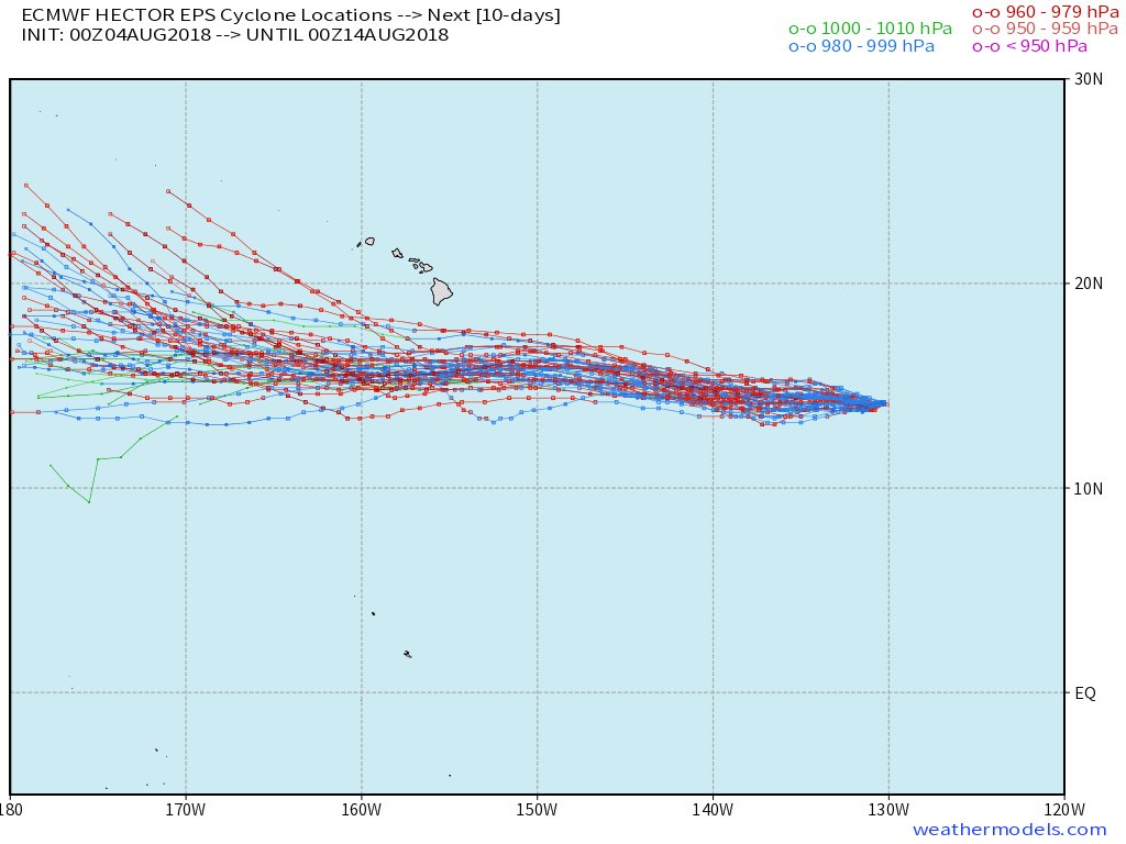
Hector has continued to move steadily westward, and the initial
motion estimate is 270/10 kt. A large subtropical ridge to the
north should steer the hurricane generally westward through the
entire forecast period. There is still uncertainty as to how much
latitude Hector will gain in the 2 to 4 day time frame due to a
slight weakness in the ridge, however the spread of the track
guidance has generally decreased since yesterday. The official
track forecast has been nudged very slightly northward, in line with
the latest consensus guidance, but overall is very similar to the
previous advisory.

There is the potential for Hector to affect portions of the Hawaiian
Islands by the middle of next week, but it is too soon to specify
the magnitude of any impacts or where they could occur. This is a
good time for everyone in the Hawaiian Islands to ensure they have
their hurricane plan in place. For additional information on any
potential local impacts from Hector in Hawaii, please refer to
products issued by the NWS Weather Forecast Office in Honolulu at
http://www.prh.noaa.gov/hnl.

FORECAST POSITIONS AND MAX WINDS

INIT 04/0900Z 14.3N 131.7W 105 KT 120 MPH
12H 04/1800Z 14.3N 133.2W 110 KT 125 MPH
24H 05/0600Z 14.5N 135.3W 110 KT 125 MPH
36H 05/1800Z 14.7N 137.6W 110 KT 125 MPH
48H 06/0600Z 15.0N 140.1W 110 KT 125 MPH
72H 07/0600Z 16.0N 145.8W 100 KT 115 MPH
96H 08/0600Z 16.5N 151.5W 90 KT 105 MPH
120H 09/0600Z 17.0N 157.5W 80 KT 90 MPH

$$
Forecaster Zelinsky
0 likes   
Visit the Caribbean-Central America Weather Thread where you can find at first post web cams,radars
and observations from Caribbean basin members Click Here

euro6208

Re: EPAC: HECTOR - Hurricane

#372 Postby euro6208 » Sat Aug 04, 2018 5:45 am

As mention many times, what a year it has been for Japan if the GFS run becomes a reality.

Record heat wave which is still ongoing...tremendous flooding...from the last 2 months.

Back to back to back TC's with Shanshan expected to miss but barely.

And now Hector? I wonder what the next 4 months will bring!
0 likes   

User avatar
Dylan
Professional-Met
Professional-Met
Posts: 338
Age: 30
Joined: Mon May 31, 2010 9:50 am
Location: New Orleans, LA

Re: EPAC: HECTOR - Hurricane

#373 Postby Dylan » Sat Aug 04, 2018 6:50 am

0z EURO ensemble members have Hector as far south as the Mariana Islands with the northern solutions showing fish. Nonetheless, a plurality of EPS members have Hector in the Western Pacific in 15 days.

Image
2 likes   
Georges('98), Allison('01), Isidore('02), Lili('02), Frances('04) Ivan('04), Cindy('05), Katrina('05), Rita('05), Gustav('08), Isaac('12), Matthew('16), Harvey('17), Irma('17), Nate ('17), Ida ('21).

User avatar
Ntxw
Storm2k Moderator
Storm2k Moderator
Posts: 22785
Joined: Wed Oct 21, 2009 6:34 pm
Location: DFW, Texas

Re: EPAC: HECTOR - Hurricane

#374 Postby Ntxw » Sat Aug 04, 2018 7:14 am

I'm thinking the NHC has been playing conservative with Hector. It has a very small eye and systems like these tends to be missed/underestimated when they have such compact cores with tiny, but warm, eyes. Visible imagery in a few will be pretty if he maintains form. We could still be watching Hector 2 weeks from now as he tries to challenge record ACE worldwide.

Image
5 likes   
The above post and any post by Ntxw is NOT an official forecast and should not be used as such. It is just the opinion of the poster and may or may not be backed by sound meteorological data. It is NOT endorsed by any professional institution including Storm2k. For official information, please refer to NWS products.

  Help support Storm2K!
Help Support Storm2K

User avatar
Dylan
Professional-Met
Professional-Met
Posts: 338
Age: 30
Joined: Mon May 31, 2010 9:50 am
Location: New Orleans, LA

Re: EPAC: HECTOR - Hurricane

#375 Postby Dylan » Sat Aug 04, 2018 7:40 am

Ntxw wrote:I'm thinking the NHC has been playing conservative with Hector. It has a very small eye and systems like these tends to be missed/underestimated when they have such compact cores with tiny, but warm, eyes. Visible imagery in a few will be pretty if he maintains form. We could still be watching Hector 2 weeks from now as he tries to challenge record ACE worldwide.


Can you share the link of the GOES floater page you're using for Hector? The link isn't on the typical floater page.
1 likes   
Georges('98), Allison('01), Isidore('02), Lili('02), Frances('04) Ivan('04), Cindy('05), Katrina('05), Rita('05), Gustav('08), Isaac('12), Matthew('16), Harvey('17), Irma('17), Nate ('17), Ida ('21).

User avatar
Ntxw
Storm2k Moderator
Storm2k Moderator
Posts: 22785
Joined: Wed Oct 21, 2009 6:34 pm
Location: DFW, Texas

Re: EPAC: HECTOR - Hurricane

#376 Postby Ntxw » Sat Aug 04, 2018 7:47 am

Dylan wrote:
Ntxw wrote:I'm thinking the NHC has been playing conservative with Hector. It has a very small eye and systems like these tends to be missed/underestimated when they have such compact cores with tiny, but warm, eyes. Visible imagery in a few will be pretty if he maintains form. We could still be watching Hector 2 weeks from now as he tries to challenge record ACE worldwide.


Can you share the link of the GOES floater page you're using for Hector? The link isn't on the typical floater page.


Sure thing, it's a little outdated but it gets you what you need on current systems. It tends to have trouble showing invests.

http://www.ssd.noaa.gov/PS/TROP/floaters-old.html
2 likes   
The above post and any post by Ntxw is NOT an official forecast and should not be used as such. It is just the opinion of the poster and may or may not be backed by sound meteorological data. It is NOT endorsed by any professional institution including Storm2k. For official information, please refer to NWS products.


  Help support Storm2K!

Help Support Storm2K


Eric Webb

Re: EPAC: HECTOR - Hurricane

#377 Postby Eric Webb » Sat Aug 04, 2018 8:04 am

0z EPS for Hector. Unanimous agreement that he'll miss Hawaii to the south and most members bring him into the Western Pacific basin fully intact as a hurricane between about 15-20N. If he loses latitude west of the dateline for a while, then all bets are off. There's only been 2 storms that were at least of tropical storm intensity on their entire trek from the EP to the WP basin; John (1994) & Dora (1999), Hector could become only the 3rd storm to do this.
Image
7 likes   

User avatar
Dylan
Professional-Met
Professional-Met
Posts: 338
Age: 30
Joined: Mon May 31, 2010 9:50 am
Location: New Orleans, LA

Re: EPAC: HECTOR - Hurricane

#378 Postby Dylan » Sat Aug 04, 2018 8:17 am

Eric Webb wrote:0z EPS for Hector. Unanimous agreement that he'll miss Hawaii to the south and most members bring him into the Western Pacific basin fully intact as a hurricane between about 15-20N. If he loses latitude west of the dateline for a while, then all bets are off. There's only been 2 storms that were at least of tropical storm intensity on their entire trek from the EP to the WP basin; John (1994) & Dora (1999), Hector could become only the 3rd storm to do this.


To add to that, it looks as though Hector will run into gradually warmer SST's as it passes south of Hawaii towards the International Date Line. Hector is a very small tropical cyclone at the moment, but I'm very interested to see the structural evolution of it over the next 2-3 weeks.

Image
4 likes   
Georges('98), Allison('01), Isidore('02), Lili('02), Frances('04) Ivan('04), Cindy('05), Katrina('05), Rita('05), Gustav('08), Isaac('12), Matthew('16), Harvey('17), Irma('17), Nate ('17), Ida ('21).

Eric Webb

Re: EPAC: HECTOR - Hurricane

#379 Postby Eric Webb » Sat Aug 04, 2018 8:25 am

Dylan wrote:
Eric Webb wrote:0z EPS for Hector. Unanimous agreement that he'll miss Hawaii to the south and most members bring him into the Western Pacific basin fully intact as a hurricane between about 15-20N. If he loses latitude west of the dateline for a while, then all bets are off. There's only been 2 storms that were at least of tropical storm intensity on their entire trek from the EP to the WP basin; John (1994) & Dora (1999), Hector could become only the 3rd storm to do this.


To add to that, it looks as though Hector will run into gradually warmer SST's as it passes south of Hawaii towards the International Date Line. Hector is a very small tropical cyclone at the moment, but I'm very interested to see the structural evolution of it over the next 2-3 weeks.

Image


Yeah I'm really intrigued to see what Hector does when he reaches the TC "holy land" that is the West Pacific Warmpool near the dateline.
3 likes   

Eric Webb

Re: EPAC: HECTOR - Hurricane

#380 Postby Eric Webb » Sat Aug 04, 2018 10:04 am

If Hector follows the NHC forecast thru the next 5 days it will have accrued about 30 ACE units by that time, what happens after this is up for debate but w/ SSTs climbing near/above 29C in its potential path there's certainly some potential for Hector to become even more intense and pile on more ACE more quickly.
2 likes   


Return to “2018”

Who is online

Users browsing this forum: No registered users and 5 guests