03/1200 UTC 14.2N 128.2W T4.5/4.5 HECTOR -- East Pacific
WPAC: HECTOR - Post-Tropical
Moderator: S2k Moderators
-
cycloneye

- Admin

- Posts: 149500
- Age: 69
- Joined: Thu Oct 10, 2002 10:54 am
- Location: San Juan, Puerto Rico
Re: EPAC: HECTOR - Hurricane
Not stronger from SAB.
0 likes
Visit the Caribbean-Central America Weather Thread where you can find at first post web cams,radars
and observations from Caribbean basin members Click Here
and observations from Caribbean basin members Click Here
-
cycloneye
- Admin
- Posts: 149500
- Age: 69
- Joined: Thu Oct 10, 2002 10:54 am
- Location: San Juan, Puerto Rico
Re: EPAC: HECTOR - Hurricane
12z Best Track is also weaker,down to 80 kts.
EP, 10, 2018080312, , BEST, 0, 141N, 1283W, 80, 983, HU
0 likes
Visit the Caribbean-Central America Weather Thread where you can find at first post web cams,radars
and observations from Caribbean basin members Click Here
and observations from Caribbean basin members Click Here
-
cycloneye
- Admin
- Posts: 149500
- Age: 69
- Joined: Thu Oct 10, 2002 10:54 am
- Location: San Juan, Puerto Rico
Re: EPAC: HECTOR - Hurricane
Hurricane Hector Discussion Number 12
NWS National Hurricane Center Miami FL EP102018
800 AM PDT Fri Aug 03 2018
The satellite presentation of Hector has degraded over the past
several hours, with only occasional hints of an eye in the latest
imagery. More notably, an AMSR2 microwave pass at 0945Z shows a
secondary eyewall structure beginning, with a ring of convection
noted at about a 30 n mi radius. All these data indicate that
Hector has weakened, so the initial wind speed is conservatively
reduced to 80 kt, near or just above the latest Dvorak estimates.
The current northeasterly shear is forecast to abate by the
numerical models during the next 12 hours, which would normally lead
to a restrengthening of Hector. However, the secondary eyewall
formation throws a wrinkle into the forecast, since that process
usually takes longer than that amount of time. As a compromise,
gradual intensification is shown starting tomorrow, with a small
uptick on Sunday as Hector reaches warmer waters in a light-shear
environment. The HWRF and HMON still show Hector becoming a major
hurricane, so it is too soon to abandon that forecast. The new
forecast is a blend of the latest corrected-consensus guidance and
the previous forecast, resulting in about a 10-kt reduction from the
last NHC prediction. Slow weakening is shown at the end of the
forecast due to cooler SSTs and potential entrainment of drier
mid-level air.
The initial motion remains 270/10 kt. A large subtropical
ridge should steer the hurricane westward for the next couple of
days, then a weakness in the ridge develops, which should cause a
more west-northwestward track. The model guidance suite is a little
slower than yesterday, about 1 or 2 kt overall. While that doesn't
sound like much, over the course of a forecast that could change
the final cyclone position by a few degrees, so it is meaningful.
In this particular case, a slower solution turns Hector to
the west-northwest earlier in the forecast, since the hurricane
feels the developing weakness to the north-northeast sooner. The
new NHC track forecast follows the trend of the model consensus and
is adjusted slightly to the north.
FORECAST POSITIONS AND MAX WINDS
INIT 03/1500Z 14.1N 128.8W 80 KT 90 MPH
12H 04/0000Z 14.2N 130.4W 80 KT 90 MPH
24H 04/1200Z 14.2N 132.4W 85 KT 100 MPH
36H 05/0000Z 14.1N 134.5W 90 KT 105 MPH
48H 05/1200Z 14.2N 136.6W 100 KT 115 MPH
72H 06/1200Z 15.1N 141.4W 100 KT 115 MPH
96H 07/1200Z 16.3N 146.7W 90 KT 105 MPH
120H 08/1200Z 17.0N 152.0W 85 KT 100 MPH
$$
Forecaster Blake
0 likes
Visit the Caribbean-Central America Weather Thread where you can find at first post web cams,radars
and observations from Caribbean basin members Click Here
and observations from Caribbean basin members Click Here
-
storminabox
- Category 1

- Posts: 263
- Joined: Sun Jul 09, 2017 10:50 pm
Re: EPAC: HECTOR - Hurricane
cycloneye wrote:Hurricane Hector Discussion Number 12
NWS National Hurricane Center Miami FL EP102018
800 AM PDT Fri Aug 03 2018
The satellite presentation of Hector has degraded over the past
several hours, with only occasional hints of an eye in the latest
imagery. More notably, an AMSR2 microwave pass at 0945Z shows a
secondary eyewall structure beginning, with a ring of convection
noted at about a 30 n mi radius. All these data indicate that
Hector has weakened, so the initial wind speed is conservatively
reduced to 80 kt, near or just above the latest Dvorak estimates.
The current northeasterly shear is forecast to abate by the
numerical models during the next 12 hours, which would normally lead
to a restrengthening of Hector. However, the secondary eyewall
formation throws a wrinkle into the forecast, since that process
usually takes longer than that amount of time. As a compromise,
gradual intensification is shown starting tomorrow, with a small
uptick on Sunday as Hector reaches warmer waters in a light-shear
environment. The HWRF and HMON still show Hector becoming a major
hurricane, so it is too soon to abandon that forecast. The new
forecast is a blend of the latest corrected-consensus guidance and
the previous forecast, resulting in about a 10-kt reduction from the
last NHC prediction. Slow weakening is shown at the end of the
forecast due to cooler SSTs and potential entrainment of drier
mid-level air.
The initial motion remains 270/10 kt. A large subtropical
ridge should steer the hurricane westward for the next couple of
days, then a weakness in the ridge develops, which should cause a
more west-northwestward track. The model guidance suite is a little
slower than yesterday, about 1 or 2 kt overall. While that doesn't
sound like much, over the course of a forecast that could change
the final cyclone position by a few degrees, so it is meaningful.
In this particular case, a slower solution turns Hector to
the west-northwest earlier in the forecast, since the hurricane
feels the developing weakness to the north-northeast sooner. The
new NHC track forecast follows the trend of the model consensus and
is adjusted slightly to the north.
FORECAST POSITIONS AND MAX WINDS
INIT 03/1500Z 14.1N 128.8W 80 KT 90 MPH
12H 04/0000Z 14.2N 130.4W 80 KT 90 MPH
24H 04/1200Z 14.2N 132.4W 85 KT 100 MPH
36H 05/0000Z 14.1N 134.5W 90 KT 105 MPH
48H 05/1200Z 14.2N 136.6W 100 KT 115 MPH
72H 06/1200Z 15.1N 141.4W 100 KT 115 MPH
96H 07/1200Z 16.3N 146.7W 90 KT 105 MPH
120H 08/1200Z 17.0N 152.0W 85 KT 100 MPH
$$
Forecaster Blake
I guess the models were right yesterday when they said that this would weaken today.
0 likes


Re: EPAC: HECTOR - Hurricane
Does look weaker overnight but it also does look like its starting to work out some of the dry air previously
1 likes
The above post and any post by Ntxw is NOT an official forecast and should not be used as such. It is just the opinion of the poster and may or may not be backed by sound meteorological data. It is NOT endorsed by any professional institution including Storm2k. For official information, please refer to NWS products.
Help support Storm2K!

-
cycloneye
- Admin
- Posts: 149500
- Age: 69
- Joined: Thu Oct 10, 2002 10:54 am
- Location: San Juan, Puerto Rico
EPAC: HECTOR - Recon
Gonzo will fly on Sunday and first mission to the Hurricane will be on Monday.
II. PACIFIC REQUIREMENTS
1. NEGATIVE RECONNAISSANCE REQUIREMENTS.
2. OUTLOOK FOR SUCCEEDING DAY.....A NOAA G-IV
SYNOPTIC SURVEILLANCE MISSION AROUND
HURRICANE HECTOR FOR 06/0000Z, DEPARTING
KLGB AT 05/1730Z.
3. ADDITIONAL DAY OUTLOOK: BEGIN 6-HRLY
FIXES FOR HURRICANE HECTOR AT 06/1730Z.
1. NEGATIVE RECONNAISSANCE REQUIREMENTS.
2. OUTLOOK FOR SUCCEEDING DAY.....A NOAA G-IV
SYNOPTIC SURVEILLANCE MISSION AROUND
HURRICANE HECTOR FOR 06/0000Z, DEPARTING
KLGB AT 05/1730Z.
3. ADDITIONAL DAY OUTLOOK: BEGIN 6-HRLY
FIXES FOR HURRICANE HECTOR AT 06/1730Z.
1 likes
Visit the Caribbean-Central America Weather Thread where you can find at first post web cams,radars
and observations from Caribbean basin members Click Here
and observations from Caribbean basin members Click Here
-
Yellow Evan

- Professional-Met

- Posts: 16240
- Age: 27
- Joined: Fri Jul 15, 2011 12:48 pm
- Location: Henderson, Nevada/Honolulu, HI
- Contact:
Re: EPAC: HECTOR - Hurricane
288
NOUS42 KNHC 031516
REPRPD
WEATHER RECONNAISSANCE FLIGHTS
CARCAH, NATIONAL HURRICANE CENTER, MIAMI, FL.
1115 AM EDT FRI 03 AUGUST 2018
SUBJECT: TROPICAL CYCLONE PLAN OF THE DAY (TCPOD)
VALID 04/1100Z TO 05/1100Z AUGUST 2018
TCPOD NUMBER.....18-071
I. ATLANTIC REQUIREMENTS
1. NEGATIVE RECONNAISSANCE REQUIREMENTS.
2. OUTLOOK FOR SUCCEEDING DAY.....NEGATIVE.
II. PACIFIC REQUIREMENTS
1. NEGATIVE RECONNAISSANCE REQUIREMENTS.
2. OUTLOOK FOR SUCCEEDING DAY.....A NOAA G-IV
SYNOPTIC SURVEILLANCE MISSION AROUND
HURRICANE HECTOR FOR 06/0000Z, DEPARTING
KLGB AT 05/1730Z.
3. ADDITIONAL DAY OUTLOOK: BEGIN 6-HRLY
FIXES FOR HURRICANE HECTOR AT 06/1730Z.
$$
WJM
1 likes
Re: EPAC: HECTOR - Hurricane
MET OFFICE TROPICAL CYCLONE GUIDANCE FOR NORTH-EAST PACIFIC AND ATLANTIC
GLOBAL MODEL DATA TIME 1200UTC 03.08.2018
HURRICANE HECTOR ANALYSED POSITION : 14.1N 128.4W
ATCF IDENTIFIER : EP102018
LEAD CENTRAL MAXIMUM WIND
VERIFYING TIME TIME POSITION PRESSURE (MB) SPEED (KNOTS)
-------------- ---- -------- ------------- -------------
1200UTC 03.08.2018 0 14.1N 128.4W 972 72
0000UTC 04.08.2018 12 14.5N 130.5W 977 61
1200UTC 04.08.2018 24 14.6N 132.8W 976 62
0000UTC 05.08.2018 36 14.3N 135.1W 975 61
1200UTC 05.08.2018 48 14.0N 137.4W 980 56
0000UTC 06.08.2018 60 13.9N 139.6W 982 56
1200UTC 06.08.2018 72 14.2N 141.8W 982 57
0000UTC 07.08.2018 84 14.8N 144.7W 976 64
1200UTC 07.08.2018 96 15.2N 147.8W 978 58
0000UTC 08.08.2018 108 15.2N 151.1W 981 54
1200UTC 08.08.2018 120 14.7N 154.2W 982 56
0000UTC 09.08.2018 132 14.3N 157.1W 983 54
1200UTC 09.08.2018 144 14.2N 159.6W 981 57
0 likes
-
Kingarabian

- S2K Supporter

- Posts: 16365
- Joined: Sat Aug 08, 2009 3:06 am
- Location: Honolulu, Hawaii
Re: EPAC: HECTOR - Hurricane
06z and 12z GFS have been very good, keeping this going well south of Hawaii and into the WPAC.
3 likes
RIP Kobe Bryant
-
cycloneye
- Admin
- Posts: 149500
- Age: 69
- Joined: Thu Oct 10, 2002 10:54 am
- Location: San Juan, Puerto Rico
Re: EPAC: HECTOR - Hurricane
Alyono wrote:MET OFFICE TROPICAL CYCLONE GUIDANCE FOR NORTH-EAST PACIFIC AND ATLANTIC
GLOBAL MODEL DATA TIME 1200UTC 03.08.2018
HURRICANE HECTOR ANALYSED POSITION : 14.1N 128.4W
ATCF IDENTIFIER : EP102018
LEAD CENTRAL MAXIMUM WIND
VERIFYING TIME TIME POSITION PRESSURE (MB) SPEED (KNOTS)
-------------- ---- -------- ------------- -------------
1200UTC 03.08.2018 0 14.1N 128.4W 972 72
0000UTC 04.08.2018 12 14.5N 130.5W 977 61
1200UTC 04.08.2018 24 14.6N 132.8W 976 62
0000UTC 05.08.2018 36 14.3N 135.1W 975 61
1200UTC 05.08.2018 48 14.0N 137.4W 980 56
0000UTC 06.08.2018 60 13.9N 139.6W 982 56
1200UTC 06.08.2018 72 14.2N 141.8W 982 57
0000UTC 07.08.2018 84 14.8N 144.7W 976 64
1200UTC 07.08.2018 96 15.2N 147.8W 978 58
0000UTC 08.08.2018 108 15.2N 151.1W 981 54
1200UTC 08.08.2018 120 14.7N 154.2W 982 56
0000UTC 09.08.2018 132 14.3N 157.1W 983 54
1200UTC 09.08.2018 144 14.2N 159.6W 981 57
UK also well south.
0 likes
Visit the Caribbean-Central America Weather Thread where you can find at first post web cams,radars
and observations from Caribbean basin members Click Here
and observations from Caribbean basin members Click Here
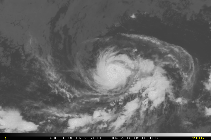
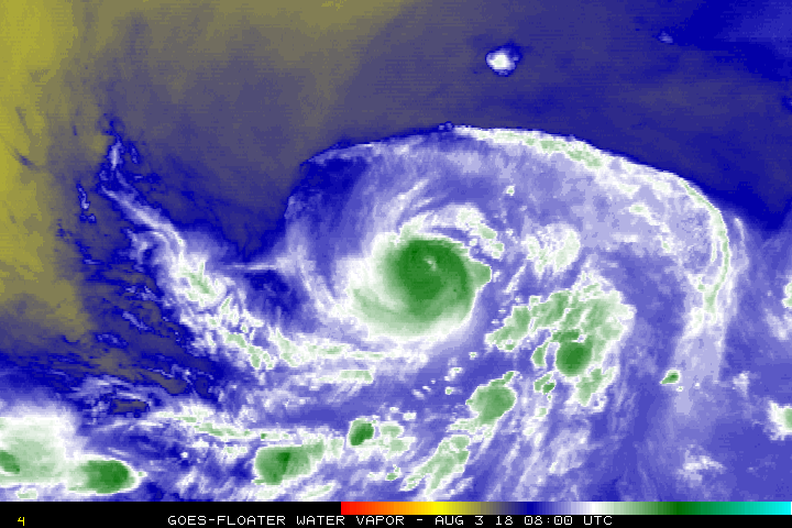
Re: EPAC: HECTOR - Hurricane
Working on the eye again. Second attempt at a major. storm is relatively small

3 likes
The above post and any post by Ntxw is NOT an official forecast and should not be used as such. It is just the opinion of the poster and may or may not be backed by sound meteorological data. It is NOT endorsed by any professional institution including Storm2k. For official information, please refer to NWS products.
Help support Storm2K!
Help support Storm2K!
-
Kingarabian
- S2K Supporter
- Posts: 16365
- Joined: Sat Aug 08, 2009 3:06 am
- Location: Honolulu, Hawaii
Re: EPAC: HECTOR - Hurricane
Ntxw wrote:Working on the eye again. Second attempt at a major. storm is relatively small
[img]http://i66.tinypic.com/wtt9ip.gif[img]
Very close to a major hurricane here. Too bad the past couple of SSMI'S passes have missed.
12z Euro is running, so far it's a bit more north than 00z.
0 likes
RIP Kobe Bryant
-
1900hurricane

- Category 5

- Posts: 6063
- Age: 34
- Joined: Fri Feb 06, 2015 12:04 pm
- Location: Houston, TX
- Contact:
Re: EPAC: HECTOR - Hurricane
Looks pretty well blocked from moving much further north by tau 96.

1 likes
Contract Meteorologist. TAMU & MSST. Fiercely authentic, one of a kind. We are all given free will, so choose a life meant to be lived. We are the Masters of our own Stories.
Opinions expressed are mine alone.
Follow me on Twitter at @1900hurricane : Read blogs at https://1900hurricane.wordpress.com/
Opinions expressed are mine alone.
Follow me on Twitter at @1900hurricane : Read blogs at https://1900hurricane.wordpress.com/
-
Kingarabian
- S2K Supporter
- Posts: 16365
- Joined: Sat Aug 08, 2009 3:06 am
- Location: Honolulu, Hawaii
Re: EPAC: HECTOR - Hurricane
1900hurricane wrote:Looks pretty well blocked from moving much further north by tau 96.
[img]https://i.imgur.com/e3qOCkZ.png[img]
Stronger ridge this time, and now moving faster than the 00z.
0 likes
RIP Kobe Bryant
-
1900hurricane
- Category 5
- Posts: 6063
- Age: 34
- Joined: Fri Feb 06, 2015 12:04 pm
- Location: Houston, TX
- Contact:
Re: EPAC: HECTOR - Hurricane
Yeah, the 00Z run really had Hector slow up quite a bit as the first trough passed by to the north. It made a huge difference in the later taus since it ended up falling behind the ridge, allowing it to slip more poleward prior to reaching the WPac. This run may send it pretty far west again.
1 likes
Contract Meteorologist. TAMU & MSST. Fiercely authentic, one of a kind. We are all given free will, so choose a life meant to be lived. We are the Masters of our own Stories.
Opinions expressed are mine alone.
Follow me on Twitter at @1900hurricane : Read blogs at https://1900hurricane.wordpress.com/
Opinions expressed are mine alone.
Follow me on Twitter at @1900hurricane : Read blogs at https://1900hurricane.wordpress.com/
-
1900hurricane
- Category 5
- Posts: 6063
- Age: 34
- Joined: Fri Feb 06, 2015 12:04 pm
- Location: Houston, TX
- Contact:
Re: EPAC: HECTOR - Hurricane
ADT's estimated wind radii (a really cool new feature with version 9.0) has a very small wind field.

1 likes
Contract Meteorologist. TAMU & MSST. Fiercely authentic, one of a kind. We are all given free will, so choose a life meant to be lived. We are the Masters of our own Stories.
Opinions expressed are mine alone.
Follow me on Twitter at @1900hurricane : Read blogs at https://1900hurricane.wordpress.com/
Opinions expressed are mine alone.
Follow me on Twitter at @1900hurricane : Read blogs at https://1900hurricane.wordpress.com/
-
Kingarabian
- S2K Supporter
- Posts: 16365
- Joined: Sat Aug 08, 2009 3:06 am
- Location: Honolulu, Hawaii
Re: EPAC: HECTOR - Hurricane
1900hurricane wrote:Yeah, the 00Z run really had Hector slow up quite a bit as the first trough passed by to the north. It made a huge difference in the later taus since it ended up falling behind the ridge, allowing it to slip more poleward prior to reaching the WPac. This run may send it pretty far west again.
It should be bombing out by now in the CPAC though. Don't know why the Euro is keeping it a minimal hurricane.
0 likes
RIP Kobe Bryant
-
1900hurricane
- Category 5
- Posts: 6063
- Age: 34
- Joined: Fri Feb 06, 2015 12:04 pm
- Location: Houston, TX
- Contact:
Re: EPAC: HECTOR - Hurricane
The ECMWF often lowballs the intensities of smaller systems, especially deeper in the tropics, and Hector certainly qualifies for this. There is quite a bit of surrounding dry air, but I wouldn't really take the intensities at face value.
2 likes
Contract Meteorologist. TAMU & MSST. Fiercely authentic, one of a kind. We are all given free will, so choose a life meant to be lived. We are the Masters of our own Stories.
Opinions expressed are mine alone.
Follow me on Twitter at @1900hurricane : Read blogs at https://1900hurricane.wordpress.com/
Opinions expressed are mine alone.
Follow me on Twitter at @1900hurricane : Read blogs at https://1900hurricane.wordpress.com/
-
cycloneye
- Admin
- Posts: 149500
- Age: 69
- Joined: Thu Oct 10, 2002 10:54 am
- Location: San Juan, Puerto Rico
Re: EPAC: HECTOR - Hurricane
SAB again up to 5.5.
03/1800 UTC 14.2N 129.4W T5.5/5.5 HECTOR -- East Pacific
0 likes
Visit the Caribbean-Central America Weather Thread where you can find at first post web cams,radars
and observations from Caribbean basin members Click Here
and observations from Caribbean basin members Click Here
Who is online
Users browsing this forum: No registered users and 194 guests