WPAC: EWINIAR - Post-Tropical
Moderator: S2k Moderators
- mrbagyo
- Category 5

- Posts: 3963
- Age: 33
- Joined: Thu Apr 12, 2012 9:18 am
- Location: 14.13N 120.98E
- Contact:
Re: WPAC: 05W - Tropical Depression
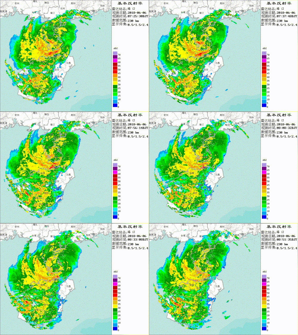
Correct me if I'm wrong but I believe the center is currently over the Leizhou Peninsula, JTWC's position  seems to be off.


0 likes
The posts in this forum are NOT official forecast and should not be used as such. They are just the opinion of the poster and may or may not be backed by sound meteorological data. They are NOT endorsed by any professional institution or storm2k.org. For official information, please refer to RSMC, NHC and NWS products.
-
euro6208
Re: WPAC: 05W - Tropical Depression
UW - CIMSS
ADVANCED DVORAK TECHNIQUE
ADT-Version 8.2.1
Tropical Cyclone Intensity Algorithm
----- Current Analysis -----
Date : 06 JUN 2018 Time : 003000 UTC
Lat : 21:02:25 N Lon : 110:44:37 E
CI# /Pressure/ Vmax
3.4 / 992.1mb/ 53.0kt
Final T# Adj T# Raw T#
3.4 3.4 3.4
Center Temp : -66.8C Cloud Region Temp : -63.7C
Scene Type : UNIFORM CDO CLOUD REGION
Positioning Method : FORECAST INTERPOLATION
Ocean Basin : WEST PACIFIC
Dvorak CI > MSLP Conversion Used : CKZ Method
Tno/CI Rules : Constraint Limits : NO LIMIT
Weakening Flag : OFF
Rapid Dissipation Flag : OFF
C/K/Z MSLP Estimate Inputs :
- Average 34 knot radii : 45km
- Environmental MSLP : 1010mb
Satellite Name : HIM-8
Satellite Viewing Angle : 41.8 degrees
****************************************************
1 likes
- NotSparta
- Professional-Met

- Posts: 1677
- Age: 24
- Joined: Fri Aug 18, 2017 8:24 am
- Location: Naples, FL
- Contact:
Re: WPAC: 05W - Tropical Depression
I'm not too sure how this is still a tropical depression.
0 likes
This post was probably an opinion of mine, and in no way is official. Please refer to http://www.hurricanes.gov for official tropical analysis and advisories.
My website, with lots of tropical wx graphics, including satellite and recon: http://cyclonicwx.com
My website, with lots of tropical wx graphics, including satellite and recon: http://cyclonicwx.com
- cycloneye
- Admin

- Posts: 149489
- Age: 69
- Joined: Thu Oct 10, 2002 10:54 am
- Location: San Juan, Puerto Rico
Re: WPAC: ENIWAR - Tropical Storm
JMA upgrades to Tropical Storm.
TS 1804 (Ewiniar)
Issued at 01:15 UTC, 6 June 2018
<Analysis at 00 UTC, 6 June>
Scale -
Intensity -
Center position N20°40' (20.7°)
E110°40' (110.7°)
Direction and speed of movement NW Slow
Central pressure 1000 hPa
Maximum wind speed near center 18 m/s (35 kt)
Maximum wind gust speed 25 m/s (50 kt)
≥ 30 kt wind area ALL 110 km (60 NM)
<Forecast for 00 UTC, 7 June>
Intensity -
Center position of probability circle N20°35' (20.6°)
E111°00' (111.0°)
Direction and speed of movement Almost stationary
Central pressure 1000 hPa
Maximum wind speed near center 18 m/s (35 kt)
Maximum wind gust speed 25 m/s (50 kt)
Radius of probability circle 110 km (60 NM)
<Forecast for 00 UTC, 8 June>
Intensity -
Center position of probability circle N21°20' (21.3°)
E111°20' (111.3°)
Direction and speed of movement Almost stationary
Central pressure 1000 hPa
Maximum wind speed near center 18 m/s (35 kt)
Maximum wind gust speed 25 m/s (50 kt)
Radius of probability circle 200 km (110 NM)
<Forecast for 00 UTC, 9 June>
Intensity -
TD
Center position of probability circle N21°55' (21.9°)
E111°40' (111.7°)
Direction and speed of movement Almost stationary
Central pressure 1004 hPa
Radius of probability circle 310 km (170 NM)
0 likes
Visit the Caribbean-Central America Weather Thread where you can find at first post web cams,radars
and observations from Caribbean basin members Click Here
and observations from Caribbean basin members Click Here
-
Twisted-core
Re: 2018 WPAC TS EWINIAR
WTPQ30 RJTD 060000
RSMC TROPICAL CYCLONE PROGNOSTIC REASONING
REASONING NO.17 FOR TS 1804 EWINIAR (1804)
1.GENERAL COMMENTS
THE SYSTEM HAS BEEN UPGRADED TO TS (EWINIAR) STATUS. TS EWINIAR IS
LOCATED AT 20.7N, 110.7E. INFORMATION ON THE CURRENT POSITION IS
BASED ON ANIMATED MSI. POSITIONAL ACCURACY IS FAIR. THE SYSTEM IS
IN A FAVORABLE ENVIRONMENT FOR DEVELOPMENT UNDER THE INFLUENCE OF
HIGH SSTS, HIGH TCHP AND WEAK VWS. THIS HAS CAUSED THE SYSTEM TO
DEVELOP OVER THE LAST SIX HOURS. INFORMATION ON CURRENT INTENSITY
IS BASED ON DVORAK INTENSITY ANALYSES.
2.SYNOPTIC SITUATION
THE SYSTEM IS MOVING SLOWLY NORTHWESTWARD DUE TO WEAK STEERING
FLOW. ANIMATED MSI SHOWS CB CLUSTERS GATHERING AROUND THE CSC.
ANIMATED MSI SHOWS GOOD CLOUD CHARACTERISTICS OF ANTICYCLONIC
OUTFLOW. WATER VAPOR IMAGERY SHOWS DRY AIR AROUND THE SYSTEM.
DMSP-F15/SSMI 89 GHZ MICROWAVE IMAGERY SHOWS THE SYSTEM HAS ACTIVE
CONVECTIVE CLOUD CLUSTERS AROUND THE CSC.
3.TRACK FORECAST
THE SYSTEM WILL MOVE EAST-SOUTHEASTWARD DUE TO WEAK STEERING FLOW
UNTIL FT24. THE SYSTEM WILL THEN MOVE NORTH-NORTHEASTWARD DUE TO
WEAK STEERING FLOW UNTIL FT72. THE JMA TRACK FORECAST IS BASED ON
GSM PREDICTIONS, AND REFERENCE TO OTHER NWP MODELS. JMA TRACK
FORECAST CONFIDENCE IS LOW DUE TO SIGNIFICANT DIFFERENCES AMONG
NUMERICAL MODEL OUTPUTS.
4.INTENSITY FORECAST
THE SYSTEM WILL MAINTAIN ITS INTENSITY UNTIL FT03 DUE TO THE
INFLUENCE OF INTERACTION WITH HIGH SSTS AND HIGH TCHP. THE SYSTEM
WILL THEN WEAKEN UNTIL FT72 DUE TO ITS LANDFALL. THE SYSTEM WILL
BE UPGRADED TO TS INTENSITY BY FT72. THE JMA INTENSITY FORECAST IS
BASED ON GUIDANCE DATA.
0 likes
-
euro6208
Re: WPAC: EWINIAR - Tropical Storm

WDPN31 PGTW 060300
MSGID/GENADMIN/JOINT TYPHOON WRNCEN PEARL HARBOR HI//
SUBJ/PROGNOSTIC REASONING FOR TROPICAL DEPRESSION 05W (FIVE) WARNING
NR 16//
RMKS/
1. FOR METEOROLOGISTS.
2. 6 HOUR SUMMARY AND ANALYSIS.
TROPICAL STORM 05W (EWINIAR), LOCATED APPROXIMATELY 225 NM WEST-
SOUTHWEST OF HONG KONG, HAS TRACKED NORTHWESTWARD AT 05 KNOTS OVER
THE PAST SIX HOURS. ANIMATED MULTISPECTRAL SATELLITE IMAGERY DEPICTS
A GROWING CENTRAL DENSE OVERCAST OVER THE LEIZHOU PENINSULA OBSCURING
THE LOW LEVEL CIRCULATION CENTER. THERE IS SIGNIFICANT UNCERTAINTY IN
THE INITIAL POSITION, HOWEVER, A 060000Z OBSERVATION FROM ZHANJIANG
TO THE NORTH INDICATES WINDS FROM THE NORTH-NORTHEAST AT 10 KNOTS,
WHICH WOULD BE CONSISTENT WITH A CENTER OFF THE EAST COAST OF THE
PENINSULA. THE INITIAL POSITION WAS PLACED NEAR THE RJTD FIX, AND
INDICATES A WESTWARD JOG OF THE BEST TRACK OVER THE PREVIOUS SIX
HOURS. THE INITIAL INTENSITY IS HELD AT 35 KNOTS, SLIGHTLY AHEAD OF
THE RJTD ESTIMATE OF T2.0 (30 KNOTS), GIVEN THE EXPANSION OF DEEP
CONVECTION. IMPROVED OUTFLOW AHEAD OF A SHORTWAVE TROUGH AND LOW
(05-10 KNOTS) VERTICAL WIND SHEAR ARE PROVIDING FAVORABLE CONDITIONS
FOR THE INCREASED CONVECTION AHEAD OF LANDFALL.
3. FORECAST REASONING.
A. THERE IS NO CHANGE IN THE FORECAST PHILOSOPHY SINCE THE
PREVIOUS PROGNOSTIC REASONING MESSAGE.
B. DESPITE THE SHORT-TERM TRACK DEVIATION, NUMERICAL GUIDANCE
INDICATES TS 05W IS FORECAST TO RETURN TO A GENERALLY NORTHWARD
TRACK, FOLLOWING THE WESTERN EXTENSION OF A STR TO THE EAST, AFTER A
PERIOD OF QUASI-STATIONARY TO LOOPING MOTION. HOWEVER, UNCERTAINTY IN
THE INITIAL POSITIONING IS RESULTING IN INCREASED UNCERTAINTY IN
FORECAST TRACK SPEEDS. GIVEN GENERALLY FAVORABLE CONDITIONS (LOW VWS,
WARM SSTS, AND FAVORABLE OUTFLOW), SLIGHT ADDITIONAL INTENSIFICATION
TO A PEAK OF 40 KNOTS IS FORECAST AS EWINIAR TRACKS OVER WATER PRIOR
TO MAKING LANDFALL NEAR TAU 24. AFTER LANDFALL, TS 05W WILL THEN
TRAVEL INLAND AND DISSIPATE TO 20 KNOTS BY TAU 48. DUE TO ERRATIC
MOTION AND UNCERTAINTY IN THE INITIAL POSITION, THERE IS LOW
CONFIDENCE IN THE JTWC FORECAST TRACK.//
NNNN
0 likes
- doomhaMwx
- Category 5

- Posts: 2487
- Age: 27
- Joined: Tue Apr 18, 2017 4:01 am
- Location: Baguio/Benguet, Philippines
- Contact:
Re: WPAC: 05W - Tropical Depression
mrbagyo wrote:Correct me if I'm wrong but I believe the center is currently over the Leizhou Peninsula, JTWC's positionseems to be off.
Seems to be making landfall / over land on this microwave image.

0 likes
-
Sciencerocks
- Category 5

- Posts: 10186
- Age: 40
- Joined: Thu Jul 06, 2017 1:51 am
Re: WPAC: 05W - Tropical Depression
Imran_doomhaMwx wrote:mrbagyo wrote:Correct me if I'm wrong but I believe the center is currently over the Leizhou Peninsula, JTWC's positionseems to be off.
Seems to be making landfall / over land on this microwave image.
Is it just me or does it appear to have at least a partial eyewall on that microwave and the structure of at least a 50-55 knot tropical storm?
0 likes
-
Twisted-core
Re: WPAC: EWINIAR - Tropical Storm
[ropical Storm EWINIAR
at 16:00 HKT 06 June 2018
Position: 20.1 N, 110.4 E (about 460 km west-southwest of Hong Kong)
Maximum sustained wind near centre: 65 km/h
Ewiniar will linger in the vicinity of Leizhou Peninsula today and tomorrow.
at 16:00 HKT 06 June 2018
Position: 20.1 N, 110.4 E (about 460 km west-southwest of Hong Kong)
Maximum sustained wind near centre: 65 km/h
Ewiniar will linger in the vicinity of Leizhou Peninsula today and tomorrow.

0 likes
-
euro6208
Re: WPAC: EWINIAR - Tropical Storm

WDPN31 PGTW 060900
MSGID/GENADMIN/JOINT TYPHOON WRNCEN PEARL HARBOR HI//
SUBJ/PROGNOSTIC REASONING FOR TROPICAL DEPRESSION 05W (FIVE)
WARNING NR 17//
RMKS/
1. FOR METEOROLOGISTS.
2. 6 HOUR SUMMARY AND ANALYSIS.
TROPICAL DEPRESSION (TD) 05W (EWINIAR), LOCATED APPROXIMATELY 254
NM WEST-SOUTHWEST OF HONG KONG, HAS TRACKED SOUTHWESTWARD AT 04 KNOTS
OVER THE PAST SIX HOURS. ANIMATED MULTISPECTRAL SATELLITE IMAGERY
SHOWS THAT DEEP CONVECTION HAS DECREASED OVER THE PAST SEVERAL HOURS.
HOWEVER, A CLEAR LOW LEVEL CIRCULATION CENTER (LLCC) REMAINS PRESENT
OVER THE SOUTHERN PORTION OF THE LEIZHUO PENINSULA. THE INITIAL
POSITION IS PLACED WITH GOOD CONFIDENCE BASED ON A 060600Z HIMAWARI
VISIBLE SATELLITE IMAGE AND PLACED NEAR THE PGTW AND RJTD 060600Z
FIXES. THE INITIAL INTENSITY OF 30 KNOTS IS BASED ON DVORAK INTENSITY
ESTIMATES OF T2.0 (30 KNOTS) FROM BOTH PGTW AND RJTD. A 060254Z
METOP-B ASCAT PASS ALSO SHOWS AN AREA OF 30 KNOT WINDS. ENVIRONMENTAL
ANALYSIS SHOWS FAVORABLE VERTICAL WIND SHEAR (5 TO 10 KNOTS) BUT
POLEWARD AND EQUATORWARD OUTFLOW CHANNELS ARE BOTH VERY WEAK. TD 05W
IS CURRENTLY LOCATED OVER LAND BUT SEA SURFACE TEMPERATURES IN THE
VICINITY REMAIN WARM, BETWEEN 27 AND 28 DEGREES CELSIUS. THE
SUBTROPICAL RIDGE (STR) WHICH IS LOCATED TO THE EAST HAS ERODED
LEAVING TD 05W UNDER WEAK STEERING CONDITIONS.
3. FORECAST REASONING.
A. THERE IS NO CHANGE IN THE FORECAST PHILOSOPHY SINCE THE
PREVIOUS PROGNOSTIC REASONING MESSAGE.
B. WEAK STEERING CONDITIONS WILL ALLOW FOR TD 05W TO SLOWLY TRACK
TO THE NORTHEAST OVER THE NEXT 24 HOURS. AS IT MOVES BACK OVER WATER
IT WILL SLIGHTLY INTENSIFY TO 35 KNOTS. BEYOND TAU 24, A WEAK WEST TO
EAST MOVING SHORTWAVE TROUGH WILL ACCELERATE TD 05W TOWARDS THE
NORTHEAST. TD 05W WILL MAKE LANDFALL IN SOUTHERN CHINA SHORTLY BEFORE
TAU 36 WITH AN INTENSITY OF 30 KNOTS. AS IT TRAVELS INLAND, TD 05W
WILL WEAKEN AND DISSIPATE TO 20 KNOTS BY TAU 48. DUE TO THE WEAK
STEERING PATTERN, DYNAMIC MODEL GUIDANCE IS IN POOR AGREEMENT.
THEREFORE, THERE IS LOW CONFIDENCE IN THE JTWC FORECAST TRACK.//
NNNN
0 likes
- mrbagyo
- Category 5

- Posts: 3963
- Age: 33
- Joined: Thu Apr 12, 2012 9:18 am
- Location: 14.13N 120.98E
- Contact:
Re: WPAC: EWINIAR - Tropical Storm

0 likes
The posts in this forum are NOT official forecast and should not be used as such. They are just the opinion of the poster and may or may not be backed by sound meteorological data. They are NOT endorsed by any professional institution or storm2k.org. For official information, please refer to RSMC, NHC and NWS products.
-
euro6208
Re: WPAC: EWINIAR - Tropical Storm
EURO and GFS agrees on this meandering around the southern coast for 4 more days and brings the remnants to Hong Kong before veering off to the east towards Taiwan.
0 likes
-
euro6208
Re: WPAC: EWINIAR - Tropical Storm


WDPN31 PGTW 070300
MSGID/GENADMIN/JOINT TYPHOON WRNCEN PEARL HARBOR HI//
SUBJ/PROGNOSTIC REASONING FOR TROPICAL DEPRESSION 05W (EWINIAR)
WARNING NR 20//
RMKS/
1. FOR METEOROLOGISTS.
2. 6 HOUR SUMMARY AND ANALYSIS.
TROPICAL DEPRESSION 05W (EWINIAR), LOCATED APPROXIMATELY 201 NM
WEST-SOUTHWEST OF HONG KONG, HAS TRACKED EAST-NORTHEASTWARD AT 04
KNOTS OVER THE PAST SIX HOURS. ANIMATED MULTISPECTRAL SATELLITE
IMAGERY (MSI) SHOWS IMPROVED BANDING WRAPPING INTO A LOW LEVEL
CIRCULATION CENTER (LLCC) CO-LOCATED WITH DEEPENING AND FLARING
CONVECTION. THE INITIAL POSITION IS PLACED WITH FAIR CONFIDENCE
BASED ON THE MSI LOOP AND A PARTIAL 062210Z 91GHZ SSMIS MICROWAVE
IMAGE DEPICTING DEEP CONVECTIVE BANDS WRAPPING AROUND THE LLCC. THE
INITIAL INTENSITY REMAINS AT 30 KNOTS BASED ON THE BANDING AND THE
070000Z PGTW CURRENT INTENSITY FIX OF T2.0 (30 KTS). HOWEVER, THE
CONVECTIVE SIGNATURE HAS IMPROVED IN THE LAST 6 HOURS, AND IT
APPEARS THAT TD 05W IS BEGINNING TO MODESTLY RE-INTENSIFY.
ENVIRONMENTAL ANALYSIS SHOWS FAVORABLE VERTICAL WIND SHEAR (5 TO 10
KNOTS) AND STRONG DUAL OUTFLOW CHANNELS. SEA SURFACE TEMPERATURES IN
THE VICINITY REMAIN WARM, BETWEEN 27 AND 29 DEGREES CELSIUS. THE
SYSTEM IS SLOWLY DRIFTING TOWARD THE NORTHEAST AS IT BEGINS TO
INTERACT WITH THE MEI- YU FRONTAL BOUNDARY.
3. FORECAST REASONING.
A. THERE IS NO CHANGE IN THE FORECAST PHILOSOPHY SINCE THE
PREVIOUS PROGNOSTIC REASONING MESSAGE.
B. A SHORTWAVE TROUGH IS MOVING THROUGH THE AREA AND PROPAGATING
EASTWARD, AND WILL CARRY TD 05W TO THE NORTHEAST AS THE PREDOMINANT
STEERING SUBTROPICAL RIDGE TO THE EAST RECEDES. SOME MODEST
INTENSIFICATION IS EXPECTED AS 05W MOVES OVER WATER BEFORE MAKING
LANDFALL OVER MAINLAND CHINA IN APPROXIMATELY 24 HOURS. AFTER
LANDFALL, TD 05W WILL CONTINUE TO TRACK NORTHEASTWARD AND DISSIPATE
OVER LAND. HOWEVER, GLOBAL MODELS SUGGEST THAT THE REMNANTS OF THE
CIRCULATION COULD EVENTUALLY MOVE BACK OVER WATER BUT IS ANTICIPATED
TO BE EMBEDDED WITHIN THE MEI-YU FRONT. THUS, THE CURRENT JTWC
FORECAST TRACK CALLS FOR TD 05W TO DISSIPATE OVER LAND BY TAU 48.
DYNAMIC MODEL GUIDANCE REMAINS IN POOR AGREEMENT WITH THE TIMING OF
THE TURN AND THE BAROCLINIC NATURE OF THE SYSTEM BEYOND TAU 48.
THERE IS LOW CONFIDENCE IN THE JTWC FORECAST TRACK.//
NNNN
0 likes
- doomhaMwx
- Category 5

- Posts: 2487
- Age: 27
- Joined: Tue Apr 18, 2017 4:01 am
- Location: Baguio/Benguet, Philippines
- Contact:
Re: WPAC: EWINIAR - Tropical Storm
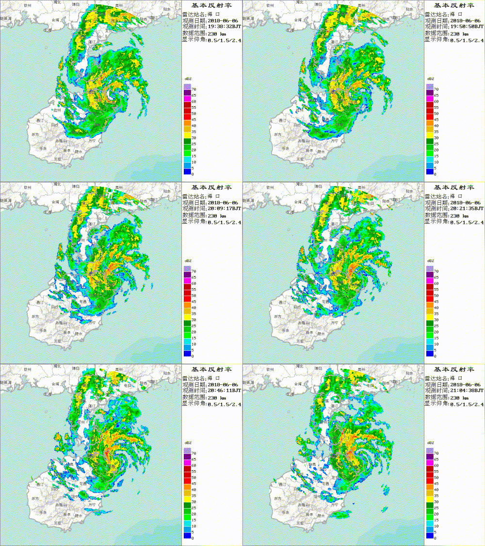
A small/compact system. Definitely reorganizing/restrengthening as it slowly moves NE back towards Guangdong.


0 likes
-
euro6208
Re: WPAC: EWINIAR - Tropical Storm
Imran_doomhaMwx wrote:A small/compact system. Definitely reorganizing/restrengthening as it slowly moves NE back towards Guangdong.
Hints of an eye?
0 likes
-
Twisted-core
Re: WPAC: EWINIAR - Tropical Storm

lots of work to do before there's any eyewall.
https://weather.us/satellite/zhanjiang/ ... .html#play
0 likes
-
euro6208
Re: WPAC: EWINIAR - Tropical Storm
CIMSS TROPICAL CYCLONE INTENSITY CONSENSUS FOR EWINIAR (05W) 2018
CURRENT ESTIMATE
Date (mmddhhmm): 06070231
SATCON: MSLP = 994 hPa MSW = 42 knots
SATCON Member Consensus: 41.0 knots
Pressure -> Wind Using SATCON MSLP: 45 knots
Distance to Outer Closed Isobar Used is 165 nm
Eye Size Correction Used is 0 knots Source: NA
Member Estimates
ADT: 998 hPa 37 knots Scene: CDO Date: JUN070310
CIMSS AMSU: 992 hPa 45 knots Bias Corr: 0 (MW) Date: 06070231
ATMS: 994.3 hPa 45.1 knots Date: 06061846
SSMIS: 994.3 hPa 45.1 knots Date: 06061846
CIRA ATMS: 1008 hPa 22 knots Date:
0 likes
-
euro6208
Re: WPAC: EWINIAR - Tropical Storm
Regains TS strength.
05W EWINIAR 180607 0600 21.0N 111.4E WPAC 35 996
05W EWINIAR 180607 0600 21.0N 111.4E WPAC 35 996
0 likes
Who is online
Users browsing this forum: No registered users and 76 guests


