BULLETIN
Subtropical Storm Alberto Advisory Number 14
NWS National Hurricane Center Miami FL AL012018
1000 AM CDT Mon May 28 2018
...CENTER OF ALBERTO NEARING THE COAST OF THE FLORIDA PANHANDLE...
...RAIN BANDS AND GUSTY WINDS SPREADING ONSHORE...
SUMMARY OF 1000 AM CDT...1500 UTC...INFORMATION
-----------------------------------------------
LOCATION...29.5N 85.8W
ABOUT 50 MI...80 KM WSW OF APALACHICOLA FLORIDA
ABOUT 50 MI...80 KM S OF PANAMA CITY FLORIDA
MAXIMUM SUSTAINED WINDS...60 MPH...95 KM/H
PRESENT MOVEMENT...N OR 360 DEGREES AT 8 MPH...13 KM/H
MINIMUM CENTRAL PRESSURE...992 MB...29.30 INCHES
WATCHES AND WARNINGS
--------------------
CHANGES WITH THIS ADVISORY:
The Tropical Storm Warning west of the Alabama/Florida border has
been discontinued.
The Storm Surge Watch west of Mexico Beach has been discontinued.
SUMMARY OF WATCHES AND WARNINGS IN EFFECT:
A Storm Surge Watch is in effect for...
* Suwannee River to Mexico Beach
A Tropical Storm Warning is in effect for...
* Suwannee River to the Alabama/Florida border
A Storm Surge Watch means there is a possibility of life-
threatening inundation, from rising water moving inland from the
coastline, in the indicated locations. For a depiction of areas at
risk, please see the National Weather Service Storm Surge
Watch/Warning Graphic, available at hurricanes.gov.
For storm information specific to your area, including possible
inland watches and warnings, please monitor products issued by your
local National Weather Service forecast office.
DISCUSSION AND OUTLOOK
----------------------
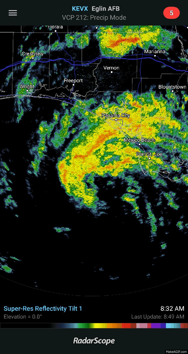
At 1000 AM CDT (1500 UTC), the center of Subtropical Storm Alberto
was located near latitude 29.5 North, longitude 85.8 West. The
storm is moving toward the north near 8 mph (13 km/h). A faster
northward or north-northwestward motion is expected during the next
few days. On the forecast track, the center of Alberto will cross
the northern Gulf Coast in the warning area this afternoon or this
evening. After landfall, the system is forecast to move well inland
into the Tennessee Valley on Tuesday and into the Ohio Valley and
Great Lakes region on Wednesday and Thursday.
Maximum sustained winds are near 60 mph (95 km/h) with higher gusts.
Little change in strength is expected before Alberto reaches
the northern Gulf Coast later today. Steady weakening is forecast
after landfall, and Alberto will likely become a subtropical
depression tonight or early Tuesday, and degenerate into a remnant
low by Tuesday afternoon.
Winds of 40 mph extend outward up to 105 miles (165 km) from the
center. An elevated observing station located about 15 miles (25
km) south of Apalachicola, Florida, recently reported sustained
winds of 47 mph (76 km/h). A sustained wind of 36 mph (57 km/h)
with a gust to 45 mph (72 km/h) have been observed at Apalachicola,
Florida within the past couple of hours.
The estimated minimum central pressure from reconnaissance aircraft
data is 992 mb (29.30 inches).
HAZARDS AFFECTING LAND
----------------------
RAINFALL: Alberto is expected to produce the following rain
accumulations through Tuesday:
Central Cuba...Additional 5 to 10 inches, isolated storm-totals of
20 to 25 inches.
The Florida panhandle across eastern and central Alabama and western
Georgia...4 to 8 inches, isolated 12 inches.
The Florida Keys and Florida peninsula...Additional 1 to 3 inches,
isolated 10 inches.
Rest of the Southeast and Tennessee Valley into the lower mid
Atlantic from Tennessee east through the Carolinas...2 to 6 inches.
Rains in Cuba could produce life-threatening flash floods and
mudslides. Flooding and flash flooding are possible in the
southeast United States, including Florida.
WIND: Tropical storm conditions will spread across the warning area
today and continue into this evening.
STORM SURGE: The combination of storm surge and the tide will cause
normally dry areas near the coast to be flooded by rising waters
moving inland from the shoreline. The water could reach the
following heights above ground somewhere in the indicated
areas if the peak surge occurs at the time of high tide...
Suwannee River to Mexico Beach...2 to 4 ft
The deepest water will occur along the immediate coast. Surge-
related flooding depends on the relative timing of the surge
and the tidal cycle, and can vary greatly over short distances. For
information specific to your area, please see products issued by
your local National Weather Service forecast office.
TORNADOES: A couple of brief tornadoes are possible today from
northern Florida into central and southern Georgia, southern South
Carolina, and southeastern Alabama.
SURF: Swells generated by Alberto will continue to affect the
eastern and northern Gulf Coast through Tuesday. These swells are
likely to cause life-threatening surf and rip current conditions.
For more information, consult products from your local weather
office.
NEXT ADVISORY
-------------
Next intermediate advisory at 100 PM CDT.
Next complete advisory at 400 PM CDT.
$$
Forecaster Brown
Subtropical Storm Alberto Discussion Number 14
NWS National Hurricane Center Miami FL AL012018
1000 AM CDT Mon May 28 2018
Alberto has struggled to produce significant deep convection since
early this morning, however, there are several bands of shallow
convection that wrap around the eastern and northern portions of the
circulation. The Air Force Reserve reconnaissance aircraft has not
found winds as high as last evening, but has reported SFMR winds of
45 to 50 kt which support an initial intensity of 50 kt. The
pressure has risen a couple of millibars with data from a recent
center dropsonde supporting a minimum pressure of 992 mb.
Since the primary convective bands are already moving onshore along
the coast of the Florida panhandle, little change in strength is
expected through landfall later today. After landfall, Alberto
should quickly weaken and become a depression tonight or early
Tuesday, then degenerate into a remnant low over the Tennessee
Valley in about 36 hours.
The latest couple of center fixes from the aircraft show that
Alberto has jogged to the east this morning. The longer-term
motion, however, is generally northward at about 7 kt. A northward
to north-northwestward motion should bring the center onshore in the
Florida panhandle this afternoon or evening. After landfall, the
system should continue generally northward around the western
portion of a mid-level ridge located over the western Atlantic.
Before the system is absorbed by a frontal boundary over Canada late
in the week, it should turn northeastward ahead of a trough moving
through the central United States. The track guidance is in
relatively good agreement, and only minor adjustments were needed
to the previous NHC track forecast.
KEY MESSAGES:
1. Heavy rainfall will lead to a significant risk of flash flooding
across the Florida Panhandle, much of Alabama, and western Georgia
through tonight, spreading northward into northern Georgia, the
western Carolinas, and Tennessee on Tuesday. A risk of flooding and
flash flooding will continue over central Cuba, the Florida Keys,
and southern Florida today.
2. Hazardous storm surge is possible along portions of the eastern
Gulf Coast today, including areas well east of the track of
Alberto's center. Residents in the storm surge watch area are
encouraged to follow guidance given by their local government
officials.
3. Tropical storm conditions are likely within portions of the
tropical storm warning area today.
4. Dangerous surf and rip current conditions will continue to
affect portions of the eastern and northern Gulf Coast through
Tuesday.
FORECAST POSITIONS AND MAX WINDS
INIT 28/1500Z 29.5N 85.8W 50 KT 60 MPH
12H 29/0000Z 30.8N 86.1W 40 KT 45 MPH...INLAND
24H 29/1200Z 33.0N 86.6W 25 KT 30 MPH...INLAND
36H 30/0000Z 35.9N 87.0W 20 KT 25 MPH...POST-TROP/REMNT LOW
48H 30/1200Z 38.9N 87.1W 15 KT 15 MPH...POST-TROP/REMNT LOW
72H 31/1200Z 44.9N 84.8W 15 KT 15 MPH...POST-TROP/REMNT LOW
96H 01/1200Z 48.5N 78.5W 15 KT 15 MPH...POST-TROP/REMNT LOW
120H 02/1200Z...DISSIPATED
$$
Forecaster Brown


 [/url]


