ATL: ALBERTO - Post-Tropical

Moderator: S2k Moderators

Message
Author
psyclone
S2K Supporter
S2K Supporter
Posts: 4762
Joined: Wed Aug 24, 2005 9:04 pm
Location: palm harbor fl

Re: ATL: INVEST 90L - Discussion: STWO- 10%-70%

#441 Postby psyclone » Wed May 23, 2018 6:38 pm

DestinHurricane wrote:NHC development area well east, may be out of the woods in destin and locations farther west


In fairness it could just as easily tilt back to the left in future updates. I'd suggest the panhandle remains in the hot zone for issues. Too soon to rule in or out. One thing that is a persistent trend is the steady increase in development probs. The NHC likes to get to 100 a dime at a time and sure enough those 10% increases now add up to a high risk of formation.
1 likes   

Aric Dunn
Category 5
Category 5
Posts: 21238
Age: 42
Joined: Sun Sep 19, 2004 9:58 pm
Location: Ready for the Chase.
Contact:

Re: ATL: INVEST 90L - Discussion: STWO- 10%-70%

#442 Postby Aric Dunn » Wed May 23, 2018 6:45 pm

There is some much increased rotation and improved clouds line developing. I would not be surprised to wake up to a well defined circ ... even over land... somewhere near the nw side of the yucatan..
0 likes   
Note: If I make a post that is brief. Please refer back to previous posts for the analysis or reasoning. I do not re-write/qoute what my initial post said each time.
If there is nothing before... then just ask :)

Space & Atmospheric Physicist, Embry-Riddle Aeronautical University,
I believe the sky is falling...

Aric Dunn
Category 5
Category 5
Posts: 21238
Age: 42
Joined: Sun Sep 19, 2004 9:58 pm
Location: Ready for the Chase.
Contact:

Re: ATL: INVEST 90L - Discussion: STWO- 10%-70%

#443 Postby Aric Dunn » Wed May 23, 2018 6:54 pm

Happening pretty quickly. straightforward as to where it is at.. curved CU line in the BOC and north of the Yuctan are increases and expanding pressures are likely falling pretty good.


http://rammb-slider.cira.colostate.edu/ ... mmb-slider
0 likes   
Note: If I make a post that is brief. Please refer back to previous posts for the analysis or reasoning. I do not re-write/qoute what my initial post said each time.
If there is nothing before... then just ask :)

Space & Atmospheric Physicist, Embry-Riddle Aeronautical University,
I believe the sky is falling...

USTropics
Professional-Met
Professional-Met
Posts: 2651
Joined: Sun Aug 12, 2007 3:45 am
Location: Florida State University

Re: ATL: INVEST 90L - Models

#444 Postby USTropics » Wed May 23, 2018 6:56 pm

GFS ensembles track density forecast for 12z:
Image

ECMWF ensemble track density forecast for 12z:
Image
0 likes   

SunnyThoughts
Category 5
Category 5
Posts: 2263
Joined: Wed Jul 09, 2003 12:42 pm
Location: Pensacola, Florida

Re: ATL: INVEST 90L - Discussion: STWO- 10%-70%

#445 Postby SunnyThoughts » Wed May 23, 2018 6:56 pm

Janie2006 wrote:Alright, alright, alright. Back in the saddle for another season.

KMOB now has an "extreme risk" of flooding for Mobile and Baldwin counties in Alabama, Stone county in Southeast Mississippi, and Okaloosa and Santa Rosa counties in Northwest Florida. I cannot imagine that KLIX hasn't done the same for coastal Mississippi and Southeast Louisiana.


Yep, already handing out free sand in Escambia and Santa Rosa Counties here in the panhandle. Probably further eastern counties as well. Stay dry everybody.
0 likes   

User avatar
gatorcane
S2K Supporter
S2K Supporter
Posts: 23691
Age: 47
Joined: Sun Mar 13, 2005 3:54 pm
Location: Boca Raton, FL

Re: ATL: INVEST 90L - Models

#446 Postby gatorcane » Wed May 23, 2018 7:04 pm

Looks like the 18Z NAVGEM has shifted east as well. Every model other than named EC has shifted east today it seems. Eastern Gulf looks quite possible at the moment.
0 likes   

WeatherEmperor
S2K Supporter
S2K Supporter
Posts: 4806
Age: 41
Joined: Thu Sep 04, 2003 2:54 pm
Location: South Florida

Re: ATL: INVEST 90L - Models

#447 Postby WeatherEmperor » Wed May 23, 2018 7:10 pm

gatorcane wrote:Looks like the 18Z NAVGEM has shifted east as well. Every model other than named EC has shifted east today it seems. Eastern Gulf looks quite possible at the moment.


Here it is approaching Florida

Image


Sent from my iPhone using Tapatalk
0 likes   

Stormcenter
S2K Supporter
S2K Supporter
Posts: 6684
Joined: Wed Sep 03, 2003 11:27 am
Location: Houston, TX

Re: ATL: INVEST 90L - Discussion: STWO- 10%-70%

#448 Postby Stormcenter » Wed May 23, 2018 7:11 pm

Typical NHC, splitting the difference between the two major models. They are still giving the GFS as much weight as the EURO, hence you that possible track cone.....no surprise.

DestinHurricane wrote:NHC development area well east, may be out of the woods in destin and locations farther west
0 likes   

User avatar
robbielyn
Category 5
Category 5
Posts: 1298
Joined: Wed May 07, 2003 9:45 am
Location: brooksville, fl

Re: ATL: INVEST 90L - Discussion: STWO- 10%-70%

#449 Postby robbielyn » Wed May 23, 2018 7:13 pm

Stormcenter wrote:Typical NHC, splitting the difference between the two major models. They are still giving the GFS as much weight as the EURO, hence you that possible track cone.....no surprise.

DestinHurricane wrote:NHC development area well east, may be out of the woods in destin and locations farther west

I disagree. Last night they were definitely going more towards the Euro. Tonight they have shifted it more east. i think they are honing in on the panhandle.
0 likes   
Robbielyn McCrary
I know just about enough to sound like I know what I'm talking about sometimes. But for your safety please follow the nhc for truly professional forecasting. :D

User avatar
AJC3
Admin
Admin
Posts: 3999
Age: 61
Joined: Tue Aug 31, 2004 7:04 pm
Location: Ballston Spa, New York
Contact:

Re: ATL: INVEST 90L - Discussion: STWO- 10%-70%

#450 Postby AJC3 » Wed May 23, 2018 7:28 pm

Come on, folks. While I realize that some are looking for the tiniest nugget of "between the lines" information, trying to parse the orientation/shape/axis of an ever-changing hatched genesis area into either (1) A NHC model of choice or (2) A potential Gulf Coast landfall location several days in advance is a stretch at best, and a wasted effort in mind-reading at worst. The text explicitly states "a subtropical or tropical depression is likely to form this weekend over the eastern or central Gulf of Mexico." Given the disparity in the global model forecasts, that's really about all anyone can say with reasonable confidence.
10 likes   

jaxfladude
Category 5
Category 5
Posts: 1249
Joined: Wed Aug 24, 2005 9:36 pm
Location: Jacksonville, Fla

Re: ATL: INVEST 90L - Discussion: STWO- 10%-70%

#451 Postby jaxfladude » Wed May 23, 2018 7:32 pm

What are the consequences for Jacksonville/Gainesville/North Eastern Florida if the latest NHC forecast track verifies, of this post time ?
0 likes   
Stay safe y'all

Aric Dunn
Category 5
Category 5
Posts: 21238
Age: 42
Joined: Sun Sep 19, 2004 9:58 pm
Location: Ready for the Chase.
Contact:

Re: ATL: INVEST 90L - Models

#452 Postby Aric Dunn » Wed May 23, 2018 7:34 pm

Being that the first initial circ os likely taking shape well inland and closer to the nw part of the Yucatan. depending on where the models initialize tonight will be key. currently, they are well east and south.. if they initialize where the apparent low pressure is than we will see a shift west.
0 likes   
Note: If I make a post that is brief. Please refer back to previous posts for the analysis or reasoning. I do not re-write/qoute what my initial post said each time.
If there is nothing before... then just ask :)

Space & Atmospheric Physicist, Embry-Riddle Aeronautical University,
I believe the sky is falling...

User avatar
AJC3
Admin
Admin
Posts: 3999
Age: 61
Joined: Tue Aug 31, 2004 7:04 pm
Location: Ballston Spa, New York
Contact:

Re: ATL: INVEST 90L - Discussion: STWO- 10%-70%

#453 Postby AJC3 » Wed May 23, 2018 7:35 pm

jaxfladude wrote:What are the consequences for Jacksonville/Gainesville/North Eastern Florida if the latest NHC forecast track verifies, of this post time ?


There is no NHC 'forecast track'. The only real official "track" of any consequence would be to connect the dots of either the WPC or TAFB spot low positions, which are coordinated amongst the agencies.
2 likes   

jaxfladude
Category 5
Category 5
Posts: 1249
Joined: Wed Aug 24, 2005 9:36 pm
Location: Jacksonville, Fla

Re: RE: Re: ATL: INVEST 90L - Discussion: STWO- 10%-70%

#454 Postby jaxfladude » Wed May 23, 2018 7:38 pm

Okay. Thanks for the correction
AJC3 wrote:
jaxfladude wrote:What are the consequences for Jacksonville/Gainesville/North Eastern Florida if the latest NHC forecast track verifies, of this post time ?


There is no NHC 'forecast track'. The only real official "track" of any consequence would be to connect the dots of either the WPC or TAFB spot low positions, which are coordinated amongst the agencies.
0 likes   
Stay safe y'all

User avatar
robbielyn
Category 5
Category 5
Posts: 1298
Joined: Wed May 07, 2003 9:45 am
Location: brooksville, fl

Re: ATL: INVEST 90L - Discussion: STWO- 10%-70%

#455 Postby robbielyn » Wed May 23, 2018 7:43 pm

AJC3 wrote:Come on, folks. While I realize that some are looking for the tiniest nugget of "between the lines" information, trying to parse the orientation/shape/axis of an ever-changing hatched genesis area into either (1) A NHC model of choice or (2) A potential Gulf Coast landfall location several days in advance is a stretch at best, and a wasted effort in mind-reading at worst. The text explicitly states "a subtropical or tropical depression is likely to form this weekend over the eastern or central Gulf of Mexico." Given the disparity in the global model forecasts, that's really about all anyone can say with reasonable confidence.

i used the words i think, which is an opinion which i am allowed to express. NHC moved the area of interest from what it was last night. We are all just sharing our thoughts which is why i love this forum.
0 likes   
Robbielyn McCrary
I know just about enough to sound like I know what I'm talking about sometimes. But for your safety please follow the nhc for truly professional forecasting. :D

User avatar
wxman57
Moderator-Pro Met
Moderator-Pro Met
Posts: 22979
Age: 67
Joined: Sat Jun 21, 2003 8:06 pm
Location: Houston, TX (southwest)

Re: ATL: INVEST 90L - Discussion

#456 Postby wxman57 » Wed May 23, 2018 7:44 pm

ronjon wrote:
boca wrote:I wish wxman57 would give us his insight on 90L now since it’s looking like a north/central GOM issue now.


He did a couple of days ago. Basically going with the GFS idea that AJC3 has been discussing in his posts. Was thinking NE GOM somewhere along FL panhandle.


GFS ensembles shifted from Apalachicola (well west of operational) to Pensacola at 12Z. Euro ensembles still say SE LA. I still like the GFS over the Euro with this system, but they're not too far apart now. My 3 day holiday weekend has turned into 12+ hr shifts and no days off. I don't like this disturbance. Die disturbance, die!
9 likes   

User avatar
gatorcane
S2K Supporter
S2K Supporter
Posts: 23691
Age: 47
Joined: Sun Mar 13, 2005 3:54 pm
Location: Boca Raton, FL

Re: ATL: INVEST 90L - Discussion: STWO- 10%-70%

#457 Postby gatorcane » Wed May 23, 2018 7:44 pm

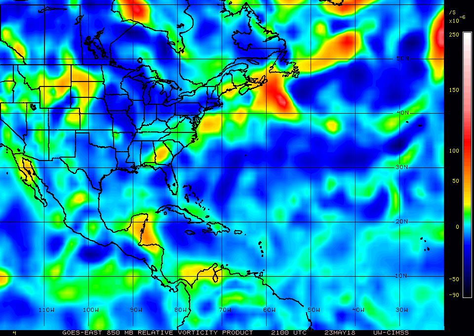
Latest 850mb vorticity map shows vorticity is increasing more over water east of Belize if you step back in 3 hour increments. The Euro wants to move the vorticity north instead over the next 24-48 hours so we will see what happens. The GFS looks to hang to the vorticity back before it slides ENE and gets absorbed by a new area of vorticity further east.

Image
Last edited by gatorcane on Wed May 23, 2018 7:49 pm, edited 1 time in total.
0 likes   

User avatar
robbielyn
Category 5
Category 5
Posts: 1298
Joined: Wed May 07, 2003 9:45 am
Location: brooksville, fl

Re: ATL: INVEST 90L - Discussion

#458 Postby robbielyn » Wed May 23, 2018 7:48 pm

wxman57 wrote:
ronjon wrote:
boca wrote:I wish wxman57 would give us his insight on 90L now since it’s looking like a north/central GOM issue now.


He did a couple of days ago. Basically going with the GFS idea that AJC3 has been discussing in his posts. Was thinking NE GOM somewhere along FL panhandle.


GFS ensembles shifted from Apalachicola (well west of operational) to Pensacola at 12Z. Euro ensembles still say SE LA. I still like the GFS over the Euro with this system, but they're not too far apart now. My 3 day holiday weekend has turned into 12+ hr shifts and no days off. I don't like this disturbance. Die disturbance, die!

Ah man that stinks! Thanks for keeping the public abreast of the situation. Starbucks for u! :D
0 likes   
Robbielyn McCrary
I know just about enough to sound like I know what I'm talking about sometimes. But for your safety please follow the nhc for truly professional forecasting. :D

User avatar
Alacane2
Tropical Storm
Tropical Storm
Posts: 127
Joined: Thu Sep 16, 2004 2:11 pm
Location: Mobile, Alabama

Re: ATL: INVEST 90L - Discussion: STWO- 10%-70%

#459 Postby Alacane2 » Wed May 23, 2018 7:57 pm

The following statement was released by the NWS in Mobile just a little while ago:


Hydrologic Outlook
ALZ051>060-261>266-FLZ201>206-MSZ067-075-076-078-079-242130-

Hydrologic Outlook
National Weather Service Mobile AL
421 PM CDT Wed May 23 2018

...Multi-Day Heavy Rainfall Event Likely Unfolding for the Central Gulf
Coast Region...

Between this Saturday and the middle of next week, a developing heavy
rainfall pattern associated with both a tropical plume of
moisture and potential Gulf of Mexico surface low development will
bring very heavy to potentially excessive rainfall, at times, to
the Central Gulf Coast Region.

Current basin average rainfall forecasts during this period are
forecast to range between 6-12 inches along the coastal counties
of Alabama and the western Florida Panhandle to 5-8" across
interior portions of southwest and south Central AL and also
interior southeast Mississippi. This discounts localized higher
rainfall totals. Despite there being still some uncertainty in
the exact forecast track of a Gulf of Mexico surface low, the
ingredients for very heavy rainfall will be in place during this
rather prolonged time period.

Current thinking is a continuous rain would overspread the region
from the south on Saturday as the Gulf of Mexico surface low
further develops and moves northward. A more continuous rainfall
continues through late Sunday and potentially into Monday.

After Monday, additional showers and thunderstorms would only add
to flooding concerns as the surface low is forecast to stall to
our west and slowly wind down. Also, as area rivers drain runoff towards
the immediate coast from late weekend on, rainfall runoff will
interact with already elevated coastal water levels to further complicate
matters.

Please realize, the above scenario discounts rainfall which may further
soak soils beyond their current state even before the aforementioned
more continuous rainfall begins on Saturday.

Confidence is high, if this amount of rainfall is realized, most
of area rivers will easily experience moderate flooding, and in some
cases major flooding.

Please also realize, while flash flooding may come to an end,
river flooding could very well extend days beyond that.

A Flash Flood Watch will likely be issued by late tomorrow or
possibly very early Friday morning. /23 JMM
0 likes   

User avatar
cycloneye
Admin
Admin
Posts: 145323
Age: 68
Joined: Thu Oct 10, 2002 10:54 am
Location: San Juan, Puerto Rico

Re: ATL: INVEST 90L - Discussion

#460 Postby cycloneye » Wed May 23, 2018 8:03 pm

00z Best Track:

Location: 19.0°N 88.4°W
Maximum Winds: 25 kt Gusts: N/A
Minimum Central Pressure: 1009 mb
Environmental Pressure: 1011 mb
Radius of Circulation: 210 NM
Radius of Maximum Wind: 150 NM


Image
0 likes   
Visit the Caribbean-Central America Weather Thread where you can find at first post web cams,radars
and observations from Caribbean basin members Click Here


Return to “2018”

Who is online

Users browsing this forum: No registered users and 3 guests