ATL: ALBERTO - Post-Tropical

Moderator: S2k Moderators

Message
Author
User avatar
robbielyn
Category 5
Category 5
Posts: 1298
Joined: Wed May 07, 2003 9:45 am
Location: brooksville, fl

Re: ATL: INVEST 90L - Discussion

#381 Postby robbielyn » Wed May 23, 2018 2:32 pm

cycloneye wrote:
Marine Weather Discussion
NWS National Hurricane Center Miami FL
300 PM EDT Wed May 23 2018

...GULF OF MEXICO...

Currently, light to moderate east-southeast winds are across the
basin with locally fresh winds near the Yucatan Channel
associated with an elongated area of low pressure extending from
the eastern Yucatan Peninsula to inland western Honduras. Seas
are generally 2 to 3 ft in the western half of the basin while
altimeter data show seas in the range of 4 to 7 ft in the eastern
Gulf. The area of low pressure is expected to further develop
off the northern coast of the Yucatan Peninsula Fri morning. The
tropical low will move slowly northward in the eastern Gulf over
the weekend with up to near gale force winds and associated seas
east of the low. The global models consensus indicate the low
will reach the offshore waters of SE Louisiana Sunday morning,
then briefly stall in that region through Monday morning when the
low moves inland SE Louisiana.
Regardless of development,
locally heavy rainfall and isolated tstms are possible over much
of Floria, the Yucatan Channel and the northeast Gulf.

https://www.nhc.noaa.gov/text/MIAMIMATS.shtml

I am confused. It says the low will move in the eastern gulf. But then mentions the low in or near louisiana which is the central gulf.
0 likes   
Robbielyn McCrary
I know just about enough to sound like I know what I'm talking about sometimes. But for your safety please follow the nhc for truly professional forecasting. :D

User avatar
robbielyn
Category 5
Category 5
Posts: 1298
Joined: Wed May 07, 2003 9:45 am
Location: brooksville, fl

Re: ATL: INVEST 90L - Discussion

#382 Postby robbielyn » Wed May 23, 2018 2:38 pm

Also i know anything can happen, but these storms usually head to fl this time of year and though we don’t need the rain, how come it’s going to LA?
Last edited by robbielyn on Wed May 23, 2018 2:52 pm, edited 1 time in total.
0 likes   
Robbielyn McCrary
I know just about enough to sound like I know what I'm talking about sometimes. But for your safety please follow the nhc for truly professional forecasting. :D

User avatar
boca
Category 5
Category 5
Posts: 6367
Age: 60
Joined: Mon Dec 15, 2003 8:49 am
Location: Boca Raton,FL

Re: ATL: INVEST 90L - Discussion

#383 Postby boca » Wed May 23, 2018 2:41 pm

Maybe it might hook and left or turn west once it’s up towards the Florida panhandle than slide along the coast until it hits Louisiana.
0 likes   

User avatar
Dylan
Professional-Met
Professional-Met
Posts: 338
Age: 30
Joined: Mon May 31, 2010 9:50 am
Location: New Orleans, LA

Re: ATL: INVEST 90L - Models

#384 Postby Dylan » Wed May 23, 2018 2:51 pm

0 likes   
Georges('98), Allison('01), Isidore('02), Lili('02), Frances('04) Ivan('04), Cindy('05), Katrina('05), Rita('05), Gustav('08), Isaac('12), Matthew('16), Harvey('17), Irma('17), Nate ('17), Ida ('21).

User avatar
gatorcane
S2K Supporter
S2K Supporter
Posts: 23691
Age: 47
Joined: Sun Mar 13, 2005 3:54 pm
Location: Boca Raton, FL

Re: ATL: INVEST 90L - Models

#385 Postby gatorcane » Wed May 23, 2018 2:52 pm

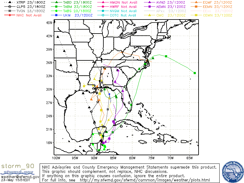
Wow look at the latest UKMET. Sends the system towards FL peninsula (like the GFS has been showing) then day 4 breaks off another low and sends it NW in the NE Gulf: :double:

You can look at all of the UKMET frames here on this link as well as the other global models:
https://ruc.noaa.gov/hfip/tcgen/

Image

Image
0 likes   

Stormcenter
S2K Supporter
S2K Supporter
Posts: 6684
Joined: Wed Sep 03, 2003 11:27 am
Location: Houston, TX

Re: ATL: INVEST 90L - Discussion

#386 Postby Stormcenter » Wed May 23, 2018 2:57 pm

Possibly a building Bermuda ridge to it's east?


robbielyn wrote:Also i know anything can happen, but these storms usually head to fl this time of year and though we don’t need the rain, how come it’s going to LA?
0 likes   

stormlover2013

Re: ATL: INVEST 90L - Models

#387 Postby stormlover2013 » Wed May 23, 2018 2:59 pm

Going to all depend when the center forms
0 likes   

User avatar
SFLcane
S2K Supporter
S2K Supporter
Posts: 10163
Age: 47
Joined: Sat Jun 05, 2010 1:44 pm
Location: Lake Worth Florida

Re: ATL: INVEST 90L - Discussion

#388 Postby SFLcane » Wed May 23, 2018 3:00 pm

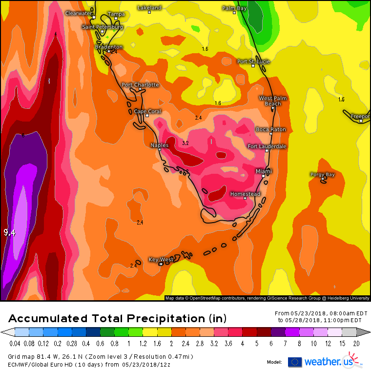
Euro precip forecast... :na:

Image
0 likes   

User avatar
SFLcane
S2K Supporter
S2K Supporter
Posts: 10163
Age: 47
Joined: Sat Jun 05, 2010 1:44 pm
Location: Lake Worth Florida

Re: ATL: INVEST 90L - Models

#389 Postby SFLcane » Wed May 23, 2018 3:03 pm

18z guidance...

Image
0 likes   

BYG Jacob

Re: ATL: INVEST 90L - Discussion

#390 Postby BYG Jacob » Wed May 23, 2018 3:10 pm

robbielyn wrote:Also i know anything can happen, but these storms usually head to fl this time of year and though we don’t need the rain, how come it’s going to LA?

You know we're in May and not October right?
0 likes   

User avatar
gatorcane
S2K Supporter
S2K Supporter
Posts: 23691
Age: 47
Joined: Sun Mar 13, 2005 3:54 pm
Location: Boca Raton, FL

Re: ATL: INVEST 90L - Discussion

#391 Postby gatorcane » Wed May 23, 2018 3:16 pm

SFLcane wrote:
boca wrote:I’m thinking that 90L will be far enough west that it will just miss us because by Saturday it will be 300 miles west of us and we will be in the sinking air just outside the circulation if you go by the Euro.


This is a very likely outcome..


Latest UKMET brings a lot of rain to South Florida and Florida with a track very similar to the GFS. I am a bit skeptical of the ECMWF Central GOM solution to be quite honest, I think shear pushes a mass of moisture over to Florida with a track more in the EGOM and closer to Florida, we'll see though.
Last edited by gatorcane on Wed May 23, 2018 3:20 pm, edited 1 time in total.
1 likes   

User avatar
Ivanhater
Storm2k Moderator
Storm2k Moderator
Posts: 11161
Age: 38
Joined: Fri Jul 01, 2005 8:25 am
Location: Pensacola

Re: ATL: INVEST 90L - Discussion

#392 Postby Ivanhater » Wed May 23, 2018 3:18 pm

Euro showing about a foot of rain for Pensacola

https://weather.us/model-charts/euro/al ... 1200z.html
1 likes   
Michael

User avatar
robbielyn
Category 5
Category 5
Posts: 1298
Joined: Wed May 07, 2003 9:45 am
Location: brooksville, fl

Re: ATL: INVEST 90L - Discussion

#393 Postby robbielyn » Wed May 23, 2018 3:23 pm

BYG Jacob wrote:
robbielyn wrote:Also i know anything can happen, but these storms usually head to fl this time of year and though we don’t need the rain, how come it’s going to LA?

You know we're in May and not October right?

Yes and storms a lot of the time go into the panhandle of fl as a lopsided system.
Last edited by robbielyn on Wed May 23, 2018 3:28 pm, edited 1 time in total.
1 likes   
Robbielyn McCrary
I know just about enough to sound like I know what I'm talking about sometimes. But for your safety please follow the nhc for truly professional forecasting. :D

psyclone
S2K Supporter
S2K Supporter
Posts: 4762
Joined: Wed Aug 24, 2005 9:04 pm
Location: palm harbor fl

Re: ATL: INVEST 90L - Discussion

#394 Postby psyclone » Wed May 23, 2018 3:27 pm

BYG Jacob wrote:
robbielyn wrote:Also i know anything can happen, but these storms usually head to fl this time of year and though we don’t need the rain, how come it’s going to LA?

You know we're in May and not October right?


She's correct. super early storms have a tendency to bend eastward at lower latitudes for the same reason they do late in the season...westerlies exert greater influence at lower latitudes. that doesn't mean it can't go to LA...in fact those westerly solutions look more probable now than they did 48 hours ago. Regardless, the QPF forecasts tell a bigger story and what they show says alot.... South Carolina and Georgia look to get more rain than much of Louisiana at this point and there is often a rather abrupt QPF cutoff on the western side compared to the east. It will be interesting to see exactly where that sets up. Someone appears likely to get a serious amount of rain and the current jackpot estimates over the Mobile CWA make sense if in fact the low does move into SE LA.
1 likes   

TheStormExpert

Re: ATL: INVEST 90L - Discussion

#395 Postby TheStormExpert » Wed May 23, 2018 3:28 pm

gatorcane wrote:
SFLcane wrote:
boca wrote:I’m thinking that 90L will be far enough west that it will just miss us because by Saturday it will be 300 miles west of us and we will be in the sinking air just outside the circulation if you go by the Euro.


This is a very likely outcome..


Latest UKMET brings a lot of rain to South Florida and Florida with a track very similar to the GFS. I am a bit skeptical of the ECMWF Central GOM solution to be quite honest, I think shear pushes a mass of moisture over to Florida with a track more in the EGOM and closer to Florida, we'll see though.

I respect your opinion but with the current guesstimated center being inland over the Yucatán wouldn’t that make the Euro more correct?
0 likes   

Stormcenter
S2K Supporter
S2K Supporter
Posts: 6684
Joined: Wed Sep 03, 2003 11:27 am
Location: Houston, TX

Re: ATL: INVEST 90L - Discussion

#396 Postby Stormcenter » Wed May 23, 2018 3:28 pm

Based on the latest EURO this may not be a "lopsided" storm after all but of course this still remains to be seen.

robbielyn wrote:
BYG Jacob wrote:
robbielyn wrote:Also i know anything can happen, but these storms usually head to fl this time of year and though we don’t need the rain, how come it’s going to LA?

You know we're in May and not October right?

Yes and storms usually go into fl as a lopsided system.
0 likes   

User avatar
northjaxpro
S2K Supporter
S2K Supporter
Posts: 8900
Joined: Mon Sep 27, 2010 11:21 am
Location: Jacksonville, FL

Re: ATL: INVEST 90L - Discussion

#397 Postby northjaxpro » Wed May 23, 2018 3:30 pm

gatorcane wrote:
SFLcane wrote:
boca wrote:I’m thinking that 90L will be far enough west that it will just miss us because by Saturday it will be 300 miles west of us and we will be in the sinking air just outside the circulation if you go by the Euro.


This is a very likely outcome..


Latest UKMET brings a lot of rain to South Florida and Florida with a track very similar to the GFS. I am a bit skeptical of the ECMWF Central GOM solution to be quite honest, I think shear pushes a mass of moisture over to Florida with a track more in the EGOM and closer to Florida, we'll see though.


I agree with this assessment. The west and southwest shear will push a large area of rain well east of where eventually the center of the cyclone ends up in the Eastern Gulf of Mexico. Much of the Florida peninsula is lilely going to be drenched unfortunately this holiday weekend.
Last edited by northjaxpro on Wed May 23, 2018 3:31 pm, edited 1 time in total.
0 likes   
NEVER, EVER SAY NEVER in the tropics and weather in general, and most importantly, with life itself!!

________________________________________________________________________________________

Fay 2008 Beryl 2012 Debby 2012 Colin 2016 Hermine 2016 Julia 2016 Matthew 2016 Irma 2017 Dorian 2019

User avatar
Evil Jeremy
S2K Supporter
S2K Supporter
Posts: 5463
Age: 32
Joined: Mon Apr 10, 2006 2:10 pm
Location: Los Angeles, CA

Re: ATL: INVEST 90L - Discussion

#398 Postby Evil Jeremy » Wed May 23, 2018 3:30 pm

I can't remember the last time model divergence caused such a stir, especially over such a minor system (yes, I know, heavy rain threat, but compared to monsters we've tracked here this is minor).

Just so everyone knows, here's the current score:
GFS = X
ECMWF = X(+/- Y)
TABs = X-∞

Anyways, prepping for a wet extended weekend. 90L should be nothing more than a friendly reminder to get your hurricane kits in order.
3 likes   
Frances 04 / Jeanne 04 / Katrina 05 / Wilma 05 / Fay 08 / Debby 12 / Andrea 13 / Colin 16 / Hermine 16 / Matthew 16 / Irma 17

User avatar
robbielyn
Category 5
Category 5
Posts: 1298
Joined: Wed May 07, 2003 9:45 am
Location: brooksville, fl

Re: ATL: INVEST 90L - Discussion

#399 Postby robbielyn » Wed May 23, 2018 3:34 pm

Evil Jeremy wrote:I can't remember the last time model divergence caused such a stir, especially over such a minor system (yes, I know, heavy rain threat, but compared to monsters we've tracked here this is minor).

Just so everyone knows, here's the current score:
GFS = X
ECMWF = X(+/- Y)
TABs = X-∞

Anyways, prepping for a wet extended weekend. 90L should be nothing more than a friendly reminder to get your hurricane kits in order.

The main fact this is our first storm and that it is may is the reason for the interest. Let us enjoy our tracking please. :D
2 likes   
Robbielyn McCrary
I know just about enough to sound like I know what I'm talking about sometimes. But for your safety please follow the nhc for truly professional forecasting. :D

Aric Dunn
Category 5
Category 5
Posts: 21238
Age: 42
Joined: Sun Sep 19, 2004 9:58 pm
Location: Ready for the Chase.
Contact:

Re: ATL: INVEST 90L - Discussion

#400 Postby Aric Dunn » Wed May 23, 2018 3:36 pm

northjaxpro wrote:
gatorcane wrote:
SFLcane wrote:
This is a very likely outcome..


Latest UKMET brings a lot of rain to South Florida and Florida with a track very similar to the GFS. I am a bit skeptical of the ECMWF Central GOM solution to be quite honest, I think shear pushes a mass of moisture over to Florida with a track more in the EGOM and closer to Florida, we'll see though.


I agree with this assessment. The west and southwest shear will push a large area of rain well east of where eventually the center of the cyclone ends up in the Eastern Gulf of Mexico. Much of the Florida peninsula is lilely going to be drenched unfortunately this holiday weekend.


Unfortunately, the shear will turn ssw to S which is why the center on most of the models reforms north NOT to the NE. So any GFS solution would require the trough to not be as sharp with the exit region being wider.
1 likes   
Note: If I make a post that is brief. Please refer back to previous posts for the analysis or reasoning. I do not re-write/qoute what my initial post said each time.
If there is nothing before... then just ask :)

Space & Atmospheric Physicist, Embry-Riddle Aeronautical University,
I believe the sky is falling...


Return to “2018”

Who is online

Users browsing this forum: No registered users and 4 guests