ATL: NATE - Post Tropical - Discussion
Moderator: S2k Moderators
-
gatorcane

- S2K Supporter

- Posts: 23708
- Age: 48
- Joined: Sun Mar 13, 2005 3:54 pm
- Location: Boca Raton, FL
Re: ATL: SIXTEEN - Tropical Depression - Discussion
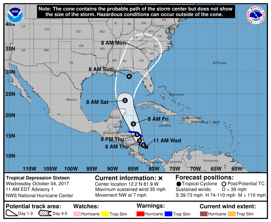
Track along right side of cone would be really not good for the Tampa area with onshore SW flow. Let's hope the east shifts have stopped but if we learned anything from IRMA it could keep shifting up to near the point of landfall.
0 likes
-
crm6360
Re: ATL: INVEST 90L - Models
Digital-TC-Chaser wrote:
156mb 100knt cane on sim.

Must be a pretty broad wind field to justify only 100kt at the surface.
1 likes
-
otowntiger
- Category 5

- Posts: 1932
- Joined: Tue Aug 31, 2004 7:06 pm
Re: ATL: INVEST 90L - Discussion
ok, thanks. I was thinking 'Extreme Intensification'. 'Explosive' sounds worse.mrbagyo wrote:otowntiger wrote:RL3AO: I appreciate your expert opinion as I do all of our Pro -Mets on here. Your thoughts here are a little ominous and duly noted. As a non professional I have a question: I know that "RI" stands for Rapid Intensification, what does "EI" stand for? Thanks!RL3AO wrote:While 90L is embedded in a large-scale monsoon gyre, the soon to be TC is looking more compact and organized than I was expected. I'm still worried that RI/EI is possible over the next couple days if it can avoid too much land interaction.
Explosive Intensification - the more extreme case of RI
Drop in central pressure at a rate of at least 2.5 mb per hour for a minimum of 12 hours.
1 likes
-
chris_fit

- Category 5
- Posts: 3261
- Age: 43
- Joined: Wed Sep 10, 2003 11:58 pm
- Location: Tampa Bay Area, FL
Re: ATL: SIXTEEN - Tropical Depression - Discussion
Amazing how the NHC pretty much scuffs the GFS for track guidance
1 likes

Re: ATL: SIXTEEN - Tropical Depression - Discussion
chris_fit wrote:Amazing how the NHC pretty much scuffs the GFS for track guidance
I believe the NHC was never fully onboard with the upgrade. I heard they were against it when it was running as Parrallel but don't have confirmation so it is not a surprise to me. It has performed poorly so far with this one no doubt.
3 likes
The following post is NOT an official forecast and should not be used as such. It is just the opinion of the poster and may or may not be backed by sound meteorological data. It is NOT endorsed by any professional institution including storm2k.org For Official Information please refer to the NHC and NWS products.

Re: ATL: SIXTEEN - Models
NAM 12Z looks reasonable too with pending landfall Escambia/Santa Rosa/Okaloosa Counties, Florida.
https://www.tropicaltidbits.com/analysi ... s=0&ypos=0
https://www.tropicaltidbits.com/analysi ... s=0&ypos=0
0 likes
-
Blown Away

- S2K Supporter
- Posts: 10253
- Joined: Wed May 26, 2004 6:17 am
Re: ATL: SIXTEEN - Tropical Depression - Discussion
blp wrote:

06z GFS... NHC seems to be pretty much discounting the GFS and hitching on the Euro...
0 likes
Hurricane Eye Experience: David 79, Irene 99, Frances 04, Jeanne 04, Wilma 05… Hurricane Brush Experience: Andrew 92, Erin 95, Floyd 99, Matthew 16, Irma 17, Ian 22, Nicole 22…
-
northjaxpro

- S2K Supporter
- Posts: 8900
- Joined: Mon Sep 27, 2010 11:21 am
- Location: Jacksonville, FL
Re: ATL: SIXTEEN - Tropical Depression - Discussion
Looking more and more that landfall probably will be somewhere from Panama City to Cedar Key. Models now are trending more east with time.
1 likes
NEVER, EVER SAY NEVER in the tropics and weather in general, and most importantly, with life itself!!
________________________________________________________________________________________
Fay 2008 Beryl 2012 Debby 2012 Colin 2016 Hermine 2016 Julia 2016 Matthew 2016 Irma 2017 Dorian 2019
________________________________________________________________________________________
Fay 2008 Beryl 2012 Debby 2012 Colin 2016 Hermine 2016 Julia 2016 Matthew 2016 Irma 2017 Dorian 2019

Re: ATL: SIXTEEN - Tropical Depression - Discussion
chris_fit wrote:Amazing how the NHC pretty much scuffs the GFS for track guidance
In a way I am not surprised, it picked up on the system just 24 hours ago so a very low confidence on the GFS at this point especially when it does not do that well against the Euro's sypnotic forecast in the 4-6 day range.
1 likes
-
Ivanhater

- Storm2k Moderator

- Posts: 11222
- Age: 39
- Joined: Fri Jul 01, 2005 8:25 am
- Location: Pensacola
Re: ATL: SIXTEEN - Tropical Depression - Discussion
Scary track for NW Florida...starting preps today
3 likes
Michael
Re: ATL: SIXTEEN - Tropical Depression - Discussion
Just as I thought RI is not out of the possibilities as mentioned by the NHC if it stays away from land while in the Caribbean.
http://www.nhc.noaa.gov/text/refresh/MI ... 1441.shtml
Other than land interaction between 24-36 hours, environmental
conditions look conducive for intensification of the depression. A
large mid/upper-level trough is forecast to drop over the SW Gulf of
Mexico, providing a low-shear environment for the cyclone. Rapid
intensification is a possibility over the northwestern Caribbean or
southern Gulf of Mexico while the system is traversing rather warm
and deep waters, although it remains to be seen how separate the
depression becomes from a larger gyre over central America. The
official intensity forecast is close to the SHIPS model, on the
high side of the intensity guidance since much of the GFS-based
tracks show much more land interaction than the official forecast.
http://www.nhc.noaa.gov/text/refresh/MI ... 1441.shtml
1 likes
-
SunnyThoughts
- Category 5
- Posts: 2263
- Joined: Wed Jul 09, 2003 12:42 pm
- Location: Pensacola, Florida
Re: ATL: SIXTEEN - Tropical Depression - Discussion
Ivanhater wrote:Scary track for NW Florida...starting preps today
Same here. Hopefully intensity stays in check, but considering this cane season, just don't know.
1 likes
-
Stormcenter
- S2K Supporter
- Posts: 6689
- Joined: Wed Sep 03, 2003 11:27 am
- Location: Houston, TX
Re: ATL: SIXTEEN - Tropical Depression - Discussion
I don't think they are entirely discounting the GFS at all. They are hedging their bets on the EURO but do put the disclaimer at the end of their discussion stating their forecast being of "low confidence" based partly on the GFS.
chris_fit wrote:Amazing how the NHC pretty much scuffs the GFS for track guidance
1 likes
-
GeneratorPower

- S2K Supporter
- Posts: 1648
- Age: 46
- Joined: Sun Dec 18, 2005 11:48 pm
- Location: Huntsville, AL
Re: ATL: SIXTEEN - Tropical Depression - Discussion
Ivanhater wrote:Scary track for NW Florida...starting preps today
Good news is there is time to prepare. That’s really fantastic. Brings back memories of all those northern Gulf Coast hits of 2004-2005. Dennis, Ivan, Etc.
4 likes
Re: ATL: SIXTEEN - Tropical Depression - Discussion
That track verbatim could really pile up the water in the forgotten coast/big bend area. A place like St George island and St Marks would really be vulnerable. Dennis (05) delivered a big water rise in that area despite landfalling well to the west. The evolution of the size of the windfield will be worth monitoring in subsequent days...in addition to track adjustments.
2 likes
-
SunnyThoughts
- Category 5
- Posts: 2263
- Joined: Wed Jul 09, 2003 12:42 pm
- Location: Pensacola, Florida
Re: ATL: SIXTEEN - Models
Steve wrote:NAM 12Z looks reasonable too with pending landfall Escambia/Santa Rosa/Okaloosa Counties, Florida.
https://www.tropicaltidbits.com/analysi ... s=0&ypos=0
How strong does that look, cat 1?
1 likes
-
Blown Away
- S2K Supporter
- Posts: 10253
- Joined: Wed May 26, 2004 6:17 am
Re: ATL: SIXTEEN - Tropical Depression - Discussion


0 likes
Hurricane Eye Experience: David 79, Irene 99, Frances 04, Jeanne 04, Wilma 05… Hurricane Brush Experience: Andrew 92, Erin 95, Floyd 99, Matthew 16, Irma 17, Ian 22, Nicole 22…
Re: ATL: SIXTEEN - Models
SunnyThoughts wrote:Steve wrote:NAM 12Z looks reasonable too with pending landfall Escambia/Santa Rosa/Okaloosa Counties, Florida.
https://www.tropicaltidbits.com/analysi ... s=0&ypos=0
How strong does that look, cat 1?
Yeah, +/-. Could be a Cat 1 or a higher-end Tropical Storm. It doesn't appear to be able to get the pressure all that low. Even in the Globals, it seems the 980s are most likely where the ceiling is. That's generally Cat 1.
0 likes
-
latitude_20

- Tropical Storm

- Posts: 196
- Joined: Wed Jun 30, 2010 6:46 am
- Location: Tulum, Mexico
- Contact:
Re: ATL: SIXTEEN - Models
SunnyThoughts wrote:Steve wrote:NAM 12Z looks reasonable too with pending landfall Escambia/Santa Rosa/Okaloosa Counties, Florida.
https://www.tropicaltidbits.com/analysi ... s=0&ypos=0
How strong does that look, cat 1?
High-end Cat 1 according to the latest HWRF. We'll know more once recon reaches the system and that data gets fed into the models.
0 likes
Re: ATL: SIXTEEN - Models
GFS,NAM and the CMC show the stronger trof I think I will put some stock in those esp.the CMC and NAM.The CMC deals more with this synoptic's of that region of the continent along with the NAM.Thinking LA/MS line to Destin.
1 likes
Who is online
Users browsing this forum: No registered users and 106 guests