ATL: MARIA - Models

Moderator: S2k Moderators

Message
Author
Aric Dunn
Category 5
Category 5
Posts: 21238
Age: 42
Joined: Sun Sep 19, 2004 9:58 pm
Location: Ready for the Chase.
Contact:

Re: ATL: MARIA - Models

#1001 Postby Aric Dunn » Mon Sep 18, 2017 11:18 pm

RL3AO wrote:
Aric Dunn wrote:
RL3AO wrote:
The GFS has shear dropping quite a bit by tomorrow. Obviously, I don't think 10 to 15 knots of shear + dry air + mediocre SSTs make a 20 mb pressure drop, but for some reason the GFS (and the Euro a little bit) think it does.


Agreed. though I'm not convinced with the shear dropping. could be more of baroclinic transition. becasue clearly an upper high is not going to build over it. the shear dropping is suspect and likely not a tropical set up.


When you look at the 200 mb wind forecast, you can see the jet streak leaving Jose behind. That may lessen shear, but it will also remove a lot of the upper-level divergence Jose has had.


That makes sense. Then you have to wonder as MW just mentioned without the forcing how is it going to strengthen? There is definately something missing here. we just have to wait a couple days I suppose.
1 likes   
Note: If I make a post that is brief. Please refer back to previous posts for the analysis or reasoning. I do not re-write/qoute what my initial post said each time.
If there is nothing before... then just ask :)

Space & Atmospheric Physicist, Embry-Riddle Aeronautical University,
I believe the sky is falling...

User avatar
Steve
S2K Supporter
S2K Supporter
Posts: 9621
Joined: Sat Apr 05, 2003 11:41 pm
Location: Not a state-caster

Re: ATL: MARIA - Models

#1002 Postby Steve » Mon Sep 18, 2017 11:18 pm

Also the GFS setup at 500mb isnt good. Stall or move west after Day 6?

https://www.tropicaltidbits.com/analysi ... 0&ypos=367

That run is 700. Here's the 500 anomaly

https://www.tropicaltidbits.com/analysi ... =27&ypos=5
Last edited by Steve on Mon Sep 18, 2017 11:21 pm, edited 2 times in total.
1 likes   

jabman98
Category 1
Category 1
Posts: 379
Joined: Fri Apr 25, 2003 12:15 pm
Location: Houston, TX

Re: ATL: MARIA - Models

#1003 Postby jabman98 » Mon Sep 18, 2017 11:19 pm

How well did the models predict Maria strengthening into a Cat 5 storm today? Seemed like a surprise to me. Could that change things any?
2 likes   

RL3AO
Moderator-Pro Met
Moderator-Pro Met
Posts: 16308
Joined: Thu Jun 14, 2007 10:03 pm
Location: NC

Re: ATL: MARIA - Models

#1004 Postby RL3AO » Mon Sep 18, 2017 11:21 pm

Aric Dunn wrote:
That makes sense. Then you have to wonder as MW just mentioned without the forcing how is it going to strengthen? There is definately something missing here. we just have to wait a couple days I suppose.


It looks like pure tropical convection and latent heat release. The GFS redevelops a symmetric precip pattern and a full eye in the simulated IR. The cross-sections also show a remarkable increase in temperatures with the core of the storm and a fully developed eyewall with four strong quadrants. That has to be caused by poor SST data.
1 likes   

Aric Dunn
Category 5
Category 5
Posts: 21238
Age: 42
Joined: Sun Sep 19, 2004 9:58 pm
Location: Ready for the Chase.
Contact:

Re: ATL: MARIA - Models

#1005 Postby Aric Dunn » Mon Sep 18, 2017 11:23 pm

What is interesting to note it that the GFS finally does weaken jose out of the 500 mb level leaving a dead swirl but by then the ridging has collapsed.


if that weakening happens faster the ridging would likely build back in.. I think the few back and forth members that have it over florida over the last couple days of the euro and GFS are battling with this issue.
0 likes   
Note: If I make a post that is brief. Please refer back to previous posts for the analysis or reasoning. I do not re-write/qoute what my initial post said each time.
If there is nothing before... then just ask :)

Space & Atmospheric Physicist, Embry-Riddle Aeronautical University,
I believe the sky is falling...

Aric Dunn
Category 5
Category 5
Posts: 21238
Age: 42
Joined: Sun Sep 19, 2004 9:58 pm
Location: Ready for the Chase.
Contact:

Re: ATL: MARIA - Models

#1006 Postby Aric Dunn » Mon Sep 18, 2017 11:26 pm

RL3AO wrote:
Aric Dunn wrote:
That makes sense. Then you have to wonder as MW just mentioned without the forcing how is it going to strengthen? There is definately something missing here. we just have to wait a couple days I suppose.


It looks like pure tropical convection and latent heat release. The GFS redevelops a symmetric precip pattern and a full eye in the simulated IR. The cross-sections also show a remarkable increase in temperatures with the core of the storm and a fully developed eyewall with four strong quadrants. That has to be caused by poor SST data.


Agreed. though there was epsilon back in 2005.. maybe some annular characteristics?
1 likes   
Note: If I make a post that is brief. Please refer back to previous posts for the analysis or reasoning. I do not re-write/qoute what my initial post said each time.
If there is nothing before... then just ask :)

Space & Atmospheric Physicist, Embry-Riddle Aeronautical University,
I believe the sky is falling...

Aric Dunn
Category 5
Category 5
Posts: 21238
Age: 42
Joined: Sun Sep 19, 2004 9:58 pm
Location: Ready for the Chase.
Contact:

Re: ATL: MARIA - Models

#1007 Postby Aric Dunn » Mon Sep 18, 2017 11:28 pm

Aric Dunn wrote:
RL3AO wrote:
Aric Dunn wrote:
That makes sense. Then you have to wonder as MW just mentioned without the forcing how is it going to strengthen? There is definately something missing here. we just have to wait a couple days I suppose.


It looks like pure tropical convection and latent heat release. The GFS redevelops a symmetric precip pattern and a full eye in the simulated IR. The cross-sections also show a remarkable increase in temperatures with the core of the storm and a fully developed eyewall with four strong quadrants. That has to be caused by poor SST data.


Agreed. though there was epsilon back in 2005.. maybe some annular characteristics?


I love the part from Avila

lol

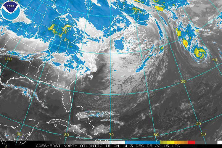
"A few hours after reaching hurricane status, the NHC thought Epsilon reached peak winds, as the storm was about to move over cooler water temperatures. Additionally, the hurricane was expected to stall near the Azores, in contrast to the original forecast of continued acceleration to the northeast.[14] On December 3 it turned due eastward, still maintaining an eye, modest amounts of convection, and outflow.[15] Despite moving into an area of cooler waters and generally unfavorable atmospheric conditions, Epsilon retained its hurricane status; the only entity supporting its intensity was its warm upper-level temperature.[16] By late on December 3, its presentation was described as "remarkably well-organized for a hurricane at high latitude in December... embedded in a strong upper-level westerly wind environment and moving over [70–72 °F (21–22 °C)] water."[17]

As it continued eastward, Epsilon developed characteristics of an annular hurricane;[1] such cyclones, more often found in the deep tropics with greater intensity, have circular eyes, surrounded by a nearly uniform ring of convection and a general lack of thunderstorms outside the ring.[18] For several days, the intensity fluctuated in a narrow range,[1] and although Epsilon was briefly downgraded to tropical storm status on December 4,[19] the NHC assessed it as remaining a hurricane.[1] After it was thought to have weakened, the eye became more symmetric as the ring of convection became stronger. The hurricane remained difficult to forecast, as NHC forecaster Lixion Avila remarked, "There are no clear reasons... and I am not going to make one up... to explain the recent strengthening of Epsilon."[20]"

maybe something like this .. but of course western atlantic :P

Image
1 likes   
Note: If I make a post that is brief. Please refer back to previous posts for the analysis or reasoning. I do not re-write/qoute what my initial post said each time.
If there is nothing before... then just ask :)

Space & Atmospheric Physicist, Embry-Riddle Aeronautical University,
I believe the sky is falling...

RL3AO
Moderator-Pro Met
Moderator-Pro Met
Posts: 16308
Joined: Thu Jun 14, 2007 10:03 pm
Location: NC

Re: ATL: MARIA - Models

#1008 Postby RL3AO » Mon Sep 18, 2017 11:31 pm

If the mid level air is cold enough (like in December), colder water can still produce a lot of CAPE.
2 likes   

Aric Dunn
Category 5
Category 5
Posts: 21238
Age: 42
Joined: Sun Sep 19, 2004 9:58 pm
Location: Ready for the Chase.
Contact:

Re: ATL: MARIA - Models

#1009 Postby Aric Dunn » Mon Sep 18, 2017 11:35 pm

RL3AO wrote:If the mid level air is cold enough (like in December), colder water can still produce a lot of CAPE.


Right.. It is the only thing logical thing I could come with given everything else.. though I do not see such cold temps in the mid levels.. or any reason why we would have a deepening hurricane and in some cases rapidly deepening hurricane over sub 80 degree water let alone low 70s
0 likes   
Note: If I make a post that is brief. Please refer back to previous posts for the analysis or reasoning. I do not re-write/qoute what my initial post said each time.
If there is nothing before... then just ask :)

Space & Atmospheric Physicist, Embry-Riddle Aeronautical University,
I believe the sky is falling...

MWatkins
S2K Supporter
S2K Supporter
Posts: 2574
Joined: Sat Oct 12, 2002 7:51 pm
Location: SE Florida
Contact:

Re: ATL: MARIA - Models

#1010 Postby MWatkins » Tue Sep 19, 2017 12:01 am

Phhht! 0Z UKMET shows Jose as "Strong" with Maria as "Moderate".

Think they should seriously consider retiring that naming convention - or - improving the resolution of the model? Maybe?

WTNT80 EGRR 190408
MET OFFICE TROPICAL CYCLONE GUIDANCE FOR NORTH-EAST PACIFIC AND ATLANTIC

GLOBAL MODEL DATA TIME 00UTC 19.09.2017

HURRICANE JOSE ANALYSED POSITION : 35.3N 71.5W
ATCF IDENTIFIER : AL122017
VERIFYING TIME POSITION STRENGTH TENDENCY
-------------- -------- -------- --------
00UTC 19.09.2017 35.3N 71.5W STRONG
12UTC 19.09.2017 36.1N 71.7W STRONG LITTLE CHANGE
00UTC 20.09.2017 37.5N 71.2W INTENSE INTENSIFYING SLIGHTLY
12UTC 20.09.2017 38.8N 69.8W STRONG LITTLE CHANGE
00UTC 21.09.2017 39.7N 68.5W STRONG WEAKENING SLIGHTLY
12UTC 21.09.2017 39.9N 67.5W MODERATE WEAKENING SLIGHTLY
00UTC 22.09.2017 39.7N 67.7W MODERATE WEAKENING SLIGHTLY
12UTC 22.09.2017 39.4N 68.4W MODERATE WEAKENING SLIGHTLY
00UTC 23.09.2017 39.1N 68.6W MODERATE LITTLE CHANGE
12UTC 23.09.2017 38.6N 69.4W MODERATE LITTLE CHANGE
00UTC 24.09.2017 38.4N 70.6W MODERATE LITTLE CHANGE
12UTC 24.09.2017 38.3N 71.5W WEAK LITTLE CHANGE
00UTC 25.09.2017 39.1N 71.8W WEAK LITTLE CHANGE


HURRICANE MARIA ANALYSED POSITION : 15.2N 61.1W
ATCF IDENTIFIER : AL152017
VERIFYING TIME POSITION STRENGTH TENDENCY
-------------- -------- -------- --------
00UTC 19.09.2017 15.2N 61.1W MODERATE
12UTC 19.09.2017 16.1N 62.4W MODERATE LITTLE CHANGE
00UTC 20.09.2017 17.0N 63.9W STRONG LITTLE CHANGE
12UTC 20.09.2017 18.0N 65.3W STRONG INTENSIFYING SLIGHTLY
00UTC 21.09.2017 18.9N 66.6W STRONG INTENSIFYING SLIGHTLY
12UTC 21.09.2017 19.7N 68.0W STRONG INTENSIFYING SLIGHTLY
00UTC 22.09.2017 20.6N 69.2W INTENSE LITTLE CHANGE
12UTC 22.09.2017 21.6N 70.1W INTENSE LITTLE CHANGE
00UTC 23.09.2017 22.8N 70.5W INTENSE INTENSIFYING SLIGHTLY
12UTC 23.09.2017 24.4N 71.3W INTENSE LITTLE CHANGE
00UTC 24.09.2017 26.1N 71.6W INTENSE INTENSIFYING SLIGHTLY
12UTC 24.09.2017 28.1N 71.7W INTENSE LITTLE CHANGE
00UTC 25.09.2017 30.2N 71.5W INTENSE LITTLE


MW
0 likes   
Updating on the twitter now: http://www.twitter.com/@watkinstrack

Aric Dunn
Category 5
Category 5
Posts: 21238
Age: 42
Joined: Sun Sep 19, 2004 9:58 pm
Location: Ready for the Chase.
Contact:

Re: ATL: MARIA - Models

#1011 Postby Aric Dunn » Tue Sep 19, 2017 12:05 am

MWatkins wrote:Phhht! 0Z UKMET shows Jose as "Strong" with Maria as "Moderate".

Think they should seriously consider retiring that naming convention - or - improving the resolution of the model? Maybe?

WTNT80 EGRR 190408
MET OFFICE TROPICAL CYCLONE GUIDANCE FOR NORTH-EAST PACIFIC AND ATLANTIC

GLOBAL MODEL DATA TIME 00UTC 19.09.2017

HURRICANE JOSE ANALYSED POSITION : 35.3N 71.5W
ATCF IDENTIFIER : AL122017
VERIFYING TIME POSITION STRENGTH TENDENCY
-------------- -------- -------- --------
00UTC 19.09.2017 35.3N 71.5W STRONG
12UTC 19.09.2017 36.1N 71.7W STRONG LITTLE CHANGE
00UTC 20.09.2017 37.5N 71.2W INTENSE INTENSIFYING SLIGHTLY
12UTC 20.09.2017 38.8N 69.8W STRONG LITTLE CHANGE
00UTC 21.09.2017 39.7N 68.5W STRONG WEAKENING SLIGHTLY
12UTC 21.09.2017 39.9N 67.5W MODERATE WEAKENING SLIGHTLY
00UTC 22.09.2017 39.7N 67.7W MODERATE WEAKENING SLIGHTLY
12UTC 22.09.2017 39.4N 68.4W MODERATE WEAKENING SLIGHTLY
00UTC 23.09.2017 39.1N 68.6W MODERATE LITTLE CHANGE
12UTC 23.09.2017 38.6N 69.4W MODERATE LITTLE CHANGE
00UTC 24.09.2017 38.4N 70.6W MODERATE LITTLE CHANGE
12UTC 24.09.2017 38.3N 71.5W WEAK LITTLE CHANGE
00UTC 25.09.2017 39.1N 71.8W WEAK LITTLE CHANGE


HURRICANE MARIA ANALYSED POSITION : 15.2N 61.1W
ATCF IDENTIFIER : AL152017
VERIFYING TIME POSITION STRENGTH TENDENCY
-------------- -------- -------- --------
00UTC 19.09.2017 15.2N 61.1W MODERATE
12UTC 19.09.2017 16.1N 62.4W MODERATE LITTLE CHANGE
00UTC 20.09.2017 17.0N 63.9W STRONG LITTLE CHANGE
12UTC 20.09.2017 18.0N 65.3W STRONG INTENSIFYING SLIGHTLY
00UTC 21.09.2017 18.9N 66.6W STRONG INTENSIFYING SLIGHTLY
12UTC 21.09.2017 19.7N 68.0W STRONG INTENSIFYING SLIGHTLY
00UTC 22.09.2017 20.6N 69.2W INTENSE LITTLE CHANGE
12UTC 22.09.2017 21.6N 70.1W INTENSE LITTLE CHANGE
00UTC 23.09.2017 22.8N 70.5W INTENSE INTENSIFYING SLIGHTLY
12UTC 23.09.2017 24.4N 71.3W INTENSE LITTLE CHANGE
00UTC 24.09.2017 26.1N 71.6W INTENSE INTENSIFYING SLIGHTLY
12UTC 24.09.2017 28.1N 71.7W INTENSE LITTLE CHANGE
00UTC 25.09.2017 30.2N 71.5W INTENSE LITTLE


MW


This is rather confusing.. nothing obvious stands out as to why..
1 likes   
Note: If I make a post that is brief. Please refer back to previous posts for the analysis or reasoning. I do not re-write/qoute what my initial post said each time.
If there is nothing before... then just ask :)

Space & Atmospheric Physicist, Embry-Riddle Aeronautical University,
I believe the sky is falling...

Alyono
Professional-Met
Professional-Met
Posts: 6961
Joined: Fri Apr 26, 2013 3:52 pm
Location: Texas Coast

Re: ATL: MARIA - Models

#1012 Postby Alyono » Tue Sep 19, 2017 12:06 am

models are hinting that the building ridge may not matter. May be enough of a weakness to allow this to stay safely off the east coast. I'd say this is the most likely scenario. Jose may have to scoot far to the east in order for this to hit now (of course, the models do seem to be trending Jose to the east)
1 likes   

Aric Dunn
Category 5
Category 5
Posts: 21238
Age: 42
Joined: Sun Sep 19, 2004 9:58 pm
Location: Ready for the Chase.
Contact:

Re: ATL: MARIA - Models

#1013 Postby Aric Dunn » Tue Sep 19, 2017 12:14 am

Alyono wrote:models are hinting that the building ridge may not matter. May be enough of a weakness to allow this to stay safely off the east coast. I'd say this is the most likely scenario. Jose may have to scoot far to the east in order for this to hit now (of course, the models do seem to be trending Jose to the east)


yes,

though jose's postion is not the real big question.. its the strength that will make all the difference.
0 likes   
Note: If I make a post that is brief. Please refer back to previous posts for the analysis or reasoning. I do not re-write/qoute what my initial post said each time.
If there is nothing before... then just ask :)

Space & Atmospheric Physicist, Embry-Riddle Aeronautical University,
I believe the sky is falling...

User avatar
artist
Category 5
Category 5
Posts: 9792
Joined: Mon Jun 06, 2005 3:26 pm
Location: West Palm

Re: ATL: MARIA - Models

#1014 Postby artist » Tue Sep 19, 2017 12:41 am

MWatkins wrote:
Aric Dunn wrote:
MWatkins wrote:FWIW: GFS shows Jose about a full 2 degrees east of the 18Z solution through half of day 5 (39/66)

MW


Yeah, though I dont think anyone is buying the strength of Jose through the period.


Can't say I'm thrilled with the 0Z run through 5 days. Maria's more or less in the exact spot from 18Z at the same V-time, but Jose connecting still to the westerlies instead of fully cut off. And, still, 0Z is stronger w/ Jose even with the eastward progression. Hopefully a new round of P3/G-IV data tomorrow will help.

MW

Good to see you, Mike.
0 likes   

Aric Dunn
Category 5
Category 5
Posts: 21238
Age: 42
Joined: Sun Sep 19, 2004 9:58 pm
Location: Ready for the Chase.
Contact:

Re: ATL: MARIA - Models

#1015 Postby Aric Dunn » Tue Sep 19, 2017 1:16 am

well damn... we dont have to stay up anymore to see the ERUO.. the SFWMD site updates track right away..

EURO even farther east.. for maria and farther south for JOSE>

I give up.. lol ill look at models in 24 hours .. this is silly.

actually wayyy east with maria..

Image
1 likes   
Note: If I make a post that is brief. Please refer back to previous posts for the analysis or reasoning. I do not re-write/qoute what my initial post said each time.
If there is nothing before... then just ask :)

Space & Atmospheric Physicist, Embry-Riddle Aeronautical University,
I believe the sky is falling...

User avatar
wxmann_91
Category 5
Category 5
Posts: 8013
Age: 34
Joined: Fri Jul 15, 2005 2:49 pm
Location: Southern California
Contact:

Re: ATL: MARIA - Models

#1016 Postby wxmann_91 » Tue Sep 19, 2017 1:23 am

Aric, that was last night's 0Z Euro run.
2 likes   

Alyono
Professional-Met
Professional-Met
Posts: 6961
Joined: Fri Apr 26, 2013 3:52 pm
Location: Texas Coast

Re: ATL: MARIA - Models

#1017 Postby Alyono » Tue Sep 19, 2017 1:25 am

when the GFS produces a more realistic solution than the EC, you just have to shake your head
4 likes   

Aric Dunn
Category 5
Category 5
Posts: 21238
Age: 42
Joined: Sun Sep 19, 2004 9:58 pm
Location: Ready for the Chase.
Contact:

Re: ATL: MARIA - Models

#1018 Postby Aric Dunn » Tue Sep 19, 2017 1:40 am

wxmann_91 wrote:Aric, that was last night's 0Z Euro run.


weird why did it just update.. lol
0 likes   
Note: If I make a post that is brief. Please refer back to previous posts for the analysis or reasoning. I do not re-write/qoute what my initial post said each time.
If there is nothing before... then just ask :)

Space & Atmospheric Physicist, Embry-Riddle Aeronautical University,
I believe the sky is falling...

Aric Dunn
Category 5
Category 5
Posts: 21238
Age: 42
Joined: Sun Sep 19, 2004 9:58 pm
Location: Ready for the Chase.
Contact:

Re: ATL: MARIA - Models

#1019 Postby Aric Dunn » Tue Sep 19, 2017 2:13 am

lol.. multiple members of the GFS have taken jose all the back down to florida.. .

really ?
1 likes   
Note: If I make a post that is brief. Please refer back to previous posts for the analysis or reasoning. I do not re-write/qoute what my initial post said each time.
If there is nothing before... then just ask :)

Space & Atmospheric Physicist, Embry-Riddle Aeronautical University,
I believe the sky is falling...

User avatar
fci
S2K Supporter
S2K Supporter
Posts: 3324
Joined: Tue Sep 14, 2004 10:29 am
Location: Lake Worth, FL

Re: ATL: MARIA - Models

#1020 Postby fci » Tue Sep 19, 2017 2:33 am

Aric Dunn wrote:lol.. multiple members of the GFS have taken jose all the back down to florida.. .

really ?


Didn't the models at one time take Matthew up to The Carolinas and then back down to Florida?
1 likes   
Personal Forecast Disclaimer:
My posts are just my opinion and are most likely not backed by sound meteorological data. They are NOT endorsed by any professional institution or storm2k.org. For official information, please refer to the NHC and NWS products.
Bottom line is that I am just expressing my opinion!!!


Return to “2017”

Who is online

Users browsing this forum: No registered users and 3 guests