

Tropical Storm Max Discussion Number 4
NWS National Hurricane Center Miami FL EP162017
400 AM CDT Thu Sep 14 2017
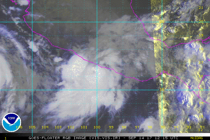
We have good data this morning. Very useful radar images from
Mexico show that Max's structure has improved during the past few
hours. An excellent ASCAT pass over the system was helpful in
determining the intensity and the tropical-storm-force wind radii.
Furthermore, the ship A8MW6 reported 45 kt winds and 11 foot waves
near the coast of Mexico. Based on these data, the initial intensity
was adjusted to 55 kt. At this point, it would only take a small
increase in intensity for Max to reach the coast as a hurricane.
Once the center moves inland the cyclone is forecast to weaken
quickly and dissipate within 36 hours.
Max is moving toward the east-northeast or 070 degrees at 5 kt. The
storm is embedded within a west-southwest flow and this flow
pattern will steer Max toward Mexico until dissipation. Based on
the forecast track, the core should be inland within the warning
area within the next 12 hours.
Max will produce life-threatening flooding rainfall in portions of
the states of Guerrero and Oaxaca.
FORECAST POSITIONS AND MAX WINDS
INIT 14/0900Z 16.6N 100.5W 55 KT 65 MPH
12H 14/1800Z 16.9N 99.7W 60 KT 70 MPH...INLAND
24H 15/0600Z 17.0N 99.0W 35 KT 40 MPH...INLAND
36H 15/1800Z...DISSIPATED
$$
Forecaster Avila
NWS National Hurricane Center Miami FL EP162017
400 AM CDT Thu Sep 14 2017
We have good data this morning. Very useful radar images from
Mexico show that Max's structure has improved during the past few
hours. An excellent ASCAT pass over the system was helpful in
determining the intensity and the tropical-storm-force wind radii.
Furthermore, the ship A8MW6 reported 45 kt winds and 11 foot waves
near the coast of Mexico. Based on these data, the initial intensity
was adjusted to 55 kt. At this point, it would only take a small
increase in intensity for Max to reach the coast as a hurricane.
Once the center moves inland the cyclone is forecast to weaken
quickly and dissipate within 36 hours.
Max is moving toward the east-northeast or 070 degrees at 5 kt. The
storm is embedded within a west-southwest flow and this flow
pattern will steer Max toward Mexico until dissipation. Based on
the forecast track, the core should be inland within the warning
area within the next 12 hours.
Max will produce life-threatening flooding rainfall in portions of
the states of Guerrero and Oaxaca.
FORECAST POSITIONS AND MAX WINDS
INIT 14/0900Z 16.6N 100.5W 55 KT 65 MPH
12H 14/1800Z 16.9N 99.7W 60 KT 70 MPH...INLAND
24H 15/0600Z 17.0N 99.0W 35 KT 40 MPH...INLAND
36H 15/1800Z...DISSIPATED
$$
Forecaster Avila

