ATL: JOSE - Post Tropical - Discussion
Moderator: S2k Moderators
- cycloneye
- Admin

- Posts: 149291
- Age: 69
- Joined: Thu Oct 10, 2002 10:54 am
- Location: San Juan, Puerto Rico
Re: ATL: JOSE - Hurricane - Discussion
Hurricane Jose Discussion Number 30
NWS National Hurricane Center Miami FL AL122017
500 PM AST Tue Sep 12 2017
Jose's convective cloud mass has evolved from a rather shapeless
one into a comma-type pattern today. This increased organization
suggests that the cyclone is at least holding its own in terms of
intensity. The advisory intensity of 65 kt is in agreement with a
Dvorak T-number from TAFB and a Current Intensity number from SAB.
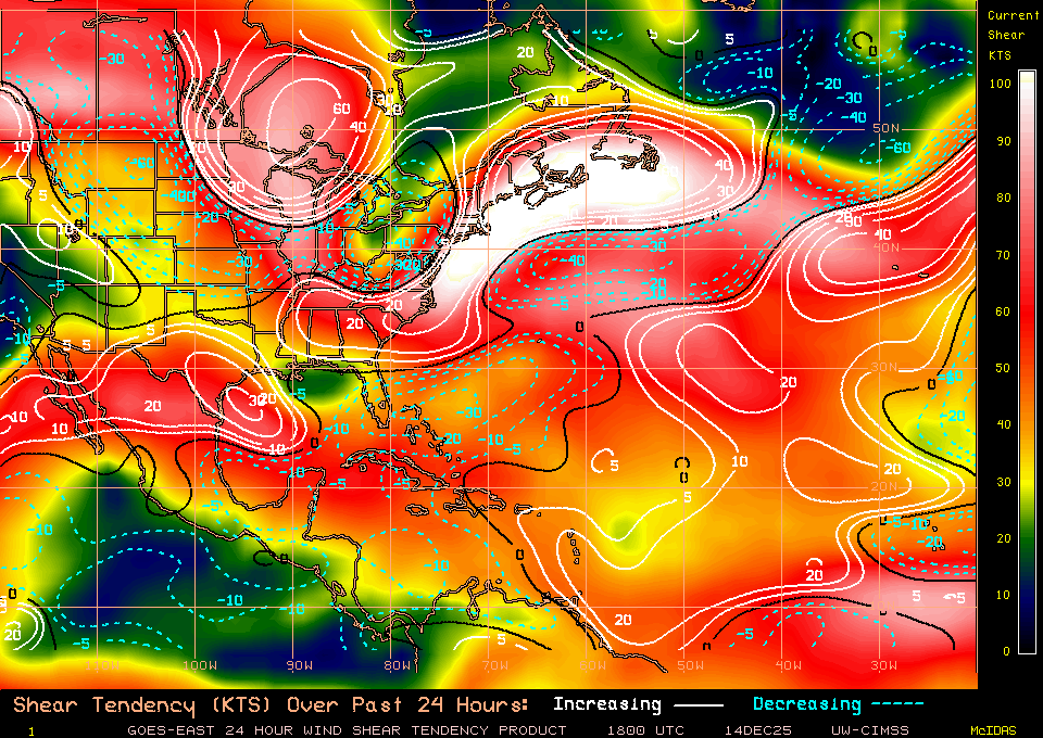
The dynamical guidance shows moderate to strong shear, from varying
directions, over Jose throughout the forecast period. The consensus
of the intensity models shows little change in strength for the
next 5 days, and so does the official forecast. This is a slight
change from the previous forecast which called for Jose to weaken
to a tropical storm within a day or so. Given the current trend
toward better organization, however, Jose could easily intensify
more than shown here.
A slight repositioning of the working best track was done using a
center fix from an excellent Windsat image from earlier today. The
initial motion estimate is a little south of east or 100/6 kt. The
GFS and ECMWF global models show a mid-level ridge building west,
then north, and then east-northeast of Jose over the next few days.
As a result, it is expected that the system will execute an
anticyclonic loop over the next 72 hours or so. Later in the
forecast period, Jose is forecast to turn northward and
north-northeastward while moving through a break in the ridge.
For unknown reasons, the U.K. Met. Office model track continues to
be well west and south of the other guidance. The official
forecast track favors the latest GFS and ECMWF solutions, but does
not go as far to the north-northeast as the ECMWF near the end of
the forecast period.
FORECAST POSITIONS AND MAX WINDS
INIT 12/2100Z 27.6N 67.4W 65 KT 75 MPH
12H 13/0600Z 27.1N 66.4W 65 KT 75 MPH
24H 13/1800Z 26.3N 65.5W 65 KT 75 MPH
36H 14/0600Z 26.0N 65.5W 65 KT 75 MPH
48H 14/1800Z 26.2N 66.6W 65 KT 75 MPH
72H 15/1800Z 27.3N 69.4W 65 KT 75 MPH
96H 16/1800Z 30.0N 71.0W 65 KT 75 MPH
120H 17/1800Z 32.5N 69.0W 65 KT 75 MPH
$$
Forecaster Pasch
0 likes
Visit the Caribbean-Central America Weather Thread where you can find at first post web cams,radars
and observations from Caribbean basin members Click Here
and observations from Caribbean basin members Click Here
-
jlauderdal
- S2K Supporter

- Posts: 7240
- Joined: Wed May 19, 2004 5:46 am
- Location: NE Fort Lauderdale
- Contact:
Re: ATL: JOSE - Hurricane - Discussion
craig setzer channel 4 miami says no jose for miami...hope he is right
0 likes
-
txwatcher91
- Category 5

- Posts: 1498
- Joined: Tue Aug 02, 2005 2:29 pm
Re: ATL: JOSE - Hurricane - Discussion
Key phrase from the discussion: "The initial motion estimate is a little south of east or 100/6 kt." The earlier ESE turn lines up much better with the UK vs the other globals... Hmmm.
1 likes
-
NJWxHurricane
- Tropical Storm

- Posts: 145
- Joined: Wed Aug 24, 2016 11:51 am
- Location: Seaside Heights, NJ (Jersey Shore)
Re: ATL: JOSE - Hurricane - Discussion
txwatcher91 wrote:Key phrase from the discussion: "The initial motion estimate is a little south of east or 100/6 kt." The earlier ESE turn lines up much better with the UK vs the other globals... Hmmm.
that's definitely not what they meant
0 likes
-
txwatcher91
- Category 5

- Posts: 1498
- Joined: Tue Aug 02, 2005 2:29 pm
Re: ATL: JOSE - Hurricane - Discussion
NJWxHurricane wrote:txwatcher91 wrote:Key phrase from the discussion: "The initial motion estimate is a little south of east or 100/6 kt." The earlier ESE turn lines up much better with the UK vs the other globals... Hmmm.
that's definitely not what they meant
I know that. My point is we have confirmation this is moving ESE now and that lines up much better with the UK model. In fact judging by final visibles of the day this looks to be turning more SE in motion now.
1 likes
Re: ATL: JOSE - Hurricane - Discussion
I cannot believe Pasch said that the UK is well south and west for unknown reasons
The reason is obvious. The UKMET is MUCH stronger
The next 48 hours will determine if Jose strikes the USA or remains well offshore
The reason is obvious. The UKMET is MUCH stronger
The next 48 hours will determine if Jose strikes the USA or remains well offshore
3 likes
-
Aric Dunn
- Category 5

- Posts: 21238
- Age: 43
- Joined: Sun Sep 19, 2004 9:58 pm
- Location: Ready for the Chase.
- Contact:
Re: ATL: JOSE - Hurricane - Discussion
Its also clearly not moving east.. ..
Also new microwave image. Pretty well organized..
Def not weakening

Also new microwave image. Pretty well organized..
Def not weakening

1 likes
Note: If I make a post that is brief. Please refer back to previous posts for the analysis or reasoning. I do not re-write/qoute what my initial post said each time.
If there is nothing before... then just ask
Space & Atmospheric Physicist, Embry-Riddle Aeronautical University,
I believe the sky is falling...
If there is nothing before... then just ask
Space & Atmospheric Physicist, Embry-Riddle Aeronautical University,
I believe the sky is falling...
- 'CaneFreak
- Category 5

- Posts: 1487
- Joined: Mon Jun 05, 2006 10:50 am
- Location: New Bern, NC
Re: ATL: JOSE - Hurricane - Discussion
Yes. Don't like to see that Shrimp shape. Not good. Other than it moving over its own wake, I don't see any reason why it can't intensify. I don't see much shear here if any at all. Our shear forecasts are horrible to put it bluntly. The UKMET may be on to something here. We definitely need to get some planes out here pronto.
Aric Dunn wrote:Its also clearly not moving east.. ..
Also new microwave image. Pretty well organized..
Def not weakening
2 likes
-
Aric Dunn
- Category 5

- Posts: 21238
- Age: 43
- Joined: Sun Sep 19, 2004 9:58 pm
- Location: Ready for the Chase.
- Contact:
Re: ATL: JOSE - Hurricane - Discussion
last couple hours it has just started really started moving to the SE..
0 likes
Note: If I make a post that is brief. Please refer back to previous posts for the analysis or reasoning. I do not re-write/qoute what my initial post said each time.
If there is nothing before... then just ask
Space & Atmospheric Physicist, Embry-Riddle Aeronautical University,
I believe the sky is falling...
If there is nothing before... then just ask
Space & Atmospheric Physicist, Embry-Riddle Aeronautical University,
I believe the sky is falling...
-
Aric Dunn
- Category 5

- Posts: 21238
- Age: 43
- Joined: Sun Sep 19, 2004 9:58 pm
- Location: Ready for the Chase.
- Contact:
Re: ATL: JOSE - Hurricane - Discussion
lol in the next few hours its going to be at the 18z postion on the 14th haha
http://www.ssd.noaa.gov/PS/TROP/floater ... -long.html
and very likely passing it to the south quite a bit farther ..
http://www.ssd.noaa.gov/PS/TROP/floater ... -long.html
and very likely passing it to the south quite a bit farther ..
1 likes
Note: If I make a post that is brief. Please refer back to previous posts for the analysis or reasoning. I do not re-write/qoute what my initial post said each time.
If there is nothing before... then just ask
Space & Atmospheric Physicist, Embry-Riddle Aeronautical University,
I believe the sky is falling...
If there is nothing before... then just ask
Space & Atmospheric Physicist, Embry-Riddle Aeronautical University,
I believe the sky is falling...
- 'CaneFreak
- Category 5

- Posts: 1487
- Joined: Mon Jun 05, 2006 10:50 am
- Location: New Bern, NC
Re: ATL: JOSE - Hurricane - Discussion
Massive -80C tops just popped up over the center again. Geez.


5 likes
- NotSparta
- Professional-Met

- Posts: 1677
- Age: 24
- Joined: Fri Aug 18, 2017 8:24 am
- Location: Naples, FL
- Contact:
Re: ATL: JOSE - Hurricane - Discussion
'CaneFreak wrote:Massive -80C tops just popped up over the center again. Geez.
This storm has found a real interest in very deep convection lately
2 likes
This post was probably an opinion of mine, and in no way is official. Please refer to http://www.hurricanes.gov for official tropical analysis and advisories.
My website, with lots of tropical wx graphics, including satellite and recon: http://cyclonicwx.com
My website, with lots of tropical wx graphics, including satellite and recon: http://cyclonicwx.com
-
Aric Dunn
- Category 5

- Posts: 21238
- Age: 43
- Joined: Sun Sep 19, 2004 9:58 pm
- Location: Ready for the Chase.
- Contact:
Re: ATL: JOSE - Hurricane - Discussion
I dont remember seeing the models moving this massive upper ridge closer to jose ? likely why its been more arganized and likely stronger now.. the weaker models will have no choice but to adjust if the intensity continues to hold..
http://tropic.ssec.wisc.edu/real-time/a ... rjava.html
and

http://tropic.ssec.wisc.edu/real-time/a ... rjava.html
and
3 likes
Note: If I make a post that is brief. Please refer back to previous posts for the analysis or reasoning. I do not re-write/qoute what my initial post said each time.
If there is nothing before... then just ask
Space & Atmospheric Physicist, Embry-Riddle Aeronautical University,
I believe the sky is falling...
If there is nothing before... then just ask
Space & Atmospheric Physicist, Embry-Riddle Aeronautical University,
I believe the sky is falling...
Re: ATL: JOSE - Hurricane - Discussion
GCANE wrote:Wow, now that's a hot tower.
Jose is wasting no time with diurnal convective maximum approaching. Going to be interesting to see what it pulls off tonight with better rotation given the explosive convection all throughout last night.
4 likes
-
Aric Dunn
- Category 5

- Posts: 21238
- Age: 43
- Joined: Sun Sep 19, 2004 9:58 pm
- Location: Ready for the Chase.
- Contact:
Re: ATL: JOSE - Hurricane - Discussion
Definately losing more latitude quicker now.. this is 3 hours old ( but just updated) and satellite is south and not much east..


6 likes
Note: If I make a post that is brief. Please refer back to previous posts for the analysis or reasoning. I do not re-write/qoute what my initial post said each time.
If there is nothing before... then just ask
Space & Atmospheric Physicist, Embry-Riddle Aeronautical University,
I believe the sky is falling...
If there is nothing before... then just ask
Space & Atmospheric Physicist, Embry-Riddle Aeronautical University,
I believe the sky is falling...
-
AutoPenalti
- Category 5

- Posts: 4091
- Age: 29
- Joined: Mon Aug 17, 2015 4:16 pm
- Location: Ft. Lauderdale, Florida
Re: ATL: JOSE - Hurricane - Discussion
Kinda freaky to see a TC move south of east.
2 likes
The posts in this forum are NOT official forecasts and should not be used as such. They are just the opinion of the poster and may or may not be backed by sound meteorological data. They are NOT endorsed by any professional institution or STORM2K. For official information, please refer to products from the NHC and NWS.
Model Runs Cheat Sheet:
GFS (5:30 AM/PM, 11:30 AM/PM)
HWRF, GFDL, UKMET, NAVGEM (6:30-8:00 AM/PM, 12:30-2:00 AM/PM)
ECMWF (1:45 AM/PM)
TCVN is a weighted averaged
-
Aric Dunn
- Category 5

- Posts: 21238
- Age: 43
- Joined: Sun Sep 19, 2004 9:58 pm
- Location: Ready for the Chase.
- Contact:
Re: ATL: JOSE - Hurricane - Discussion
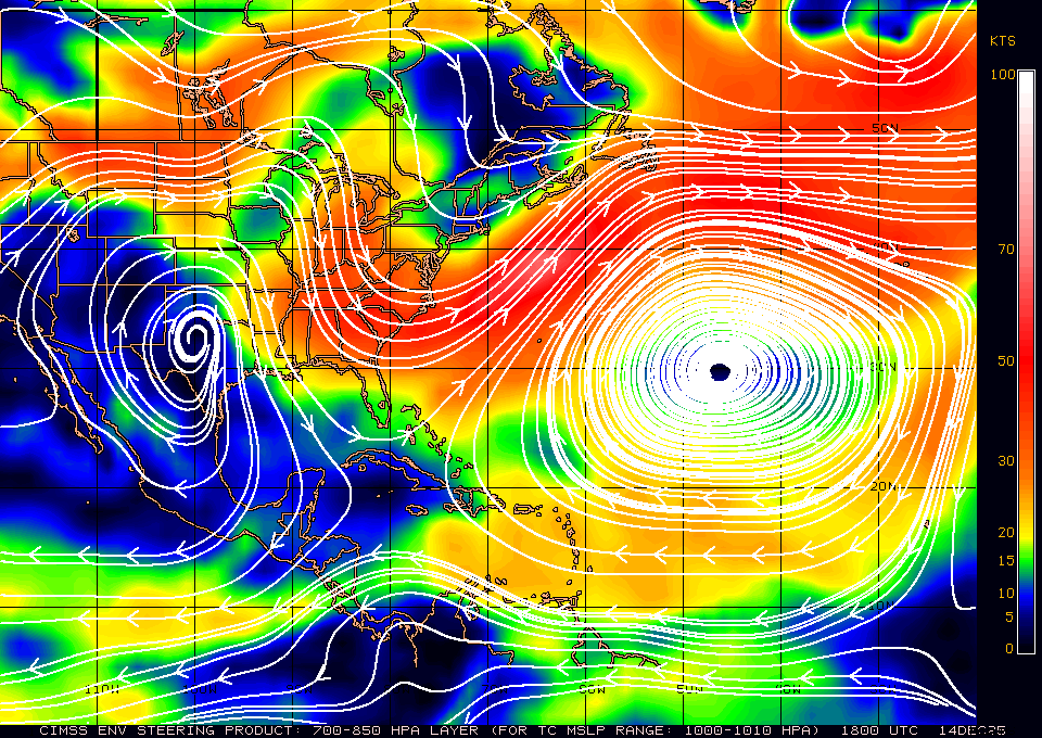
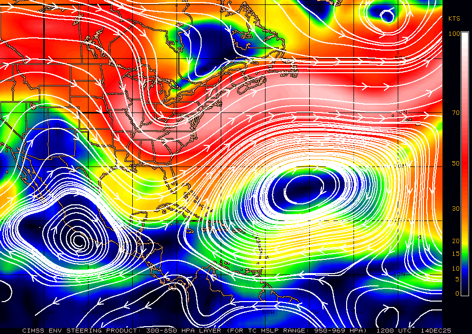
Current low level steering.. is weak
low level

while midto upper level steering ( which is what jose is following presently ) is very well pronounced and why we are seeing a more se motion and why the UKMET might be more a possibility than not.
mid to upper

low level
while midto upper level steering ( which is what jose is following presently ) is very well pronounced and why we are seeing a more se motion and why the UKMET might be more a possibility than not.
mid to upper
2 likes
Note: If I make a post that is brief. Please refer back to previous posts for the analysis or reasoning. I do not re-write/qoute what my initial post said each time.
If there is nothing before... then just ask
Space & Atmospheric Physicist, Embry-Riddle Aeronautical University,
I believe the sky is falling...
If there is nothing before... then just ask
Space & Atmospheric Physicist, Embry-Riddle Aeronautical University,
I believe the sky is falling...
-
jlauderdal
- S2K Supporter

- Posts: 7240
- Joined: Wed May 19, 2004 5:46 am
- Location: NE Fort Lauderdale
- Contact:
Re: RE: Re: ATL: JOSE - Hurricane - Discussion
I found that to be a rather odd statement too...its been well diagnosed on this thread, maybe we should send pasch the link to the model and disco thread...setzer and phill ferro both say its definitely missing us...that seems unwise considering its not unreasonable to make a run at the east coastAlyono wrote:I cannot believe Pasch said that the UK is well south and west for unknown reasons
The reason is obvious. The UKMET is MUCH stronger
The next 48 hours will determine if Jose strikes the USA or remains well offshore
3 likes
-
txwatcher91
- Category 5

- Posts: 1498
- Joined: Tue Aug 02, 2005 2:29 pm
Re: ATL: JOSE - Hurricane - Discussion
This is dropping S or SE right now at a good clip. I’d estimate the center around 26.5N already... it’s diving quickly for sure and gives a lot of weight to the UKMET idea. Nice convective explosion ongoing and heading into dmax will help too. As it plunges south it has a bit less shear to deal with too.
2 likes
Who is online
Users browsing this forum: No registered users and 16 guests


