ATL: IRMA - Post-Tropical - Discussion

Moderator: S2k Moderators

Message
Author
Aric Dunn
Category 5
Category 5
Posts: 21238
Age: 42
Joined: Sun Sep 19, 2004 9:58 pm
Location: Ready for the Chase.
Contact:

Re: ATL: IRMA - Tropical Storm - Discussion

#641 Postby Aric Dunn » Thu Aug 31, 2017 9:05 am

tgenius wrote:

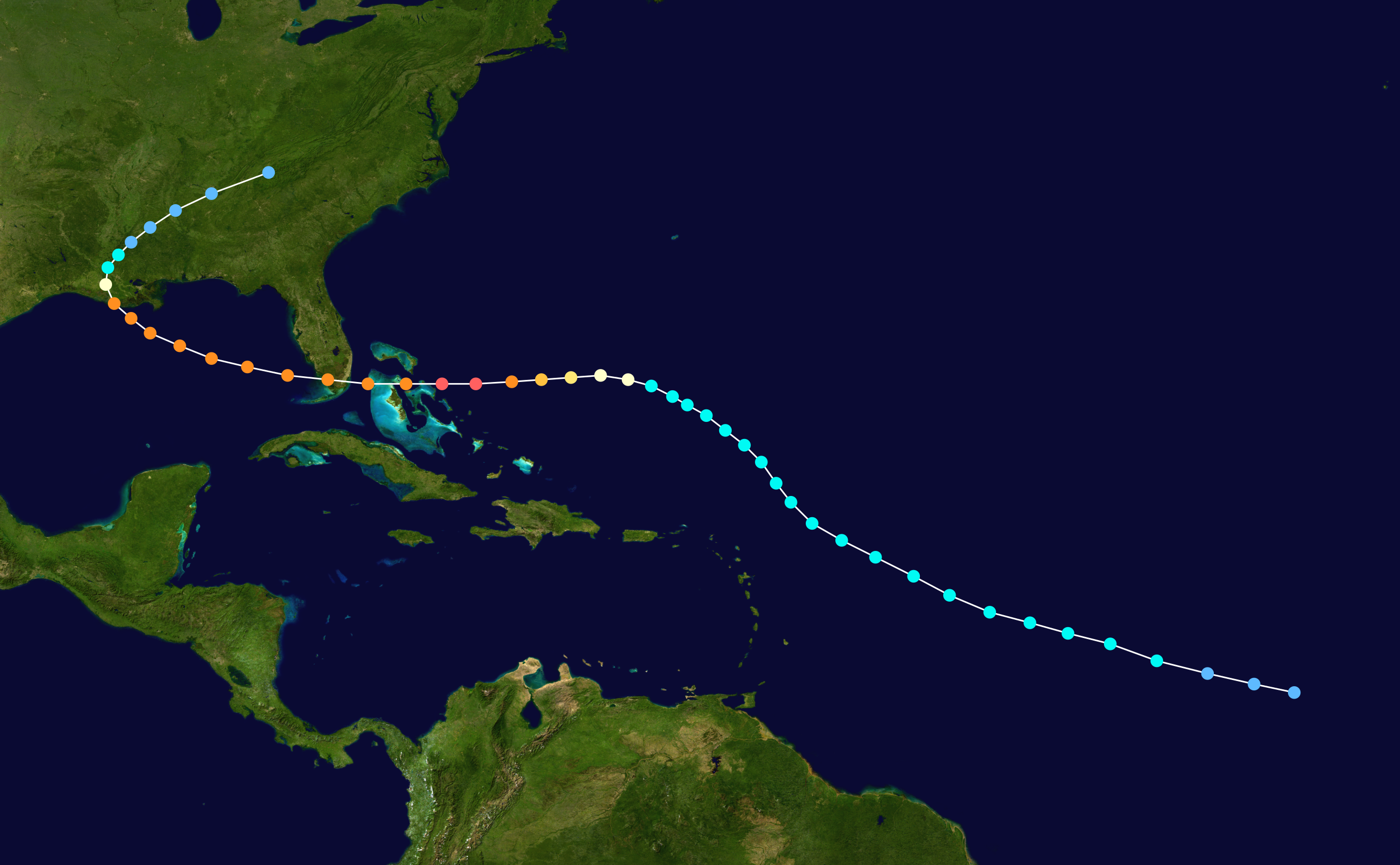
Really not liking that Analog... though Irma is forecast to do that same WSW drop.


I think the other odd part about that track is the last half looks identical to Andrew...

Image
0 likes   
Note: If I make a post that is brief. Please refer back to previous posts for the analysis or reasoning. I do not re-write/qoute what my initial post said each time.
If there is nothing before... then just ask :)

Space & Atmospheric Physicist, Embry-Riddle Aeronautical University,
I believe the sky is falling...

User avatar
KWT
Category 5
Category 5
Posts: 31415
Joined: Tue Aug 17, 2004 11:02 am
Location: UK!!!

Re: ATL: IRMA - Tropical Storm - Discussion

#642 Postby KWT » Thu Aug 31, 2017 9:10 am

Michele B wrote:I've seen storms strengthen to unbelievable numbers way out to sea, and then weaken before getting close to the US mainland.

Would this one be inclined to do the same thing, I wonder?


At this range its just about impossible to know, most models are suggesting a pretty good set-up aloft the whole way through its lifecycle so odds are its going to be in the range of a major hurricane for quite a long time with only internal stuff and land interaction possibly knocking it down.
1 likes   
Personal Forecast Disclaimer:
The posts in this forum are NOT official forecast and should not be used as such. They are just the opinion of the poster and may or may not be backed by sound meteorological data. They are NOT endorsed by any professional institution or storm2k.org. For official information, please refer to the NHC and NWS products

TheStormExpert

Re: ATL: IRMA - Tropical Storm - Discussion

#643 Postby TheStormExpert » Thu Aug 31, 2017 9:13 am

Siker wrote:Size / intensity remind me of our last major in the MDR, Danny. Danny's small eye continued to clear out, bringing him near category 4 status. Of course, he was ripped apart by shear shortly after, which Irma should have no issues with.

Unfortunately environmental conditions look a HUGE deal more favorable than they did for Danny in 2015 thanks to the absence of an El Niño. If it wasn't for that Caribbean shear you typically get in an El Niño Danny likely would've been a major hurricane threat to the U.S. that year.
0 likes   

User avatar
KWT
Category 5
Category 5
Posts: 31415
Joined: Tue Aug 17, 2004 11:02 am
Location: UK!!!

Re: ATL: IRMA - Tropical Storm - Discussion

#644 Postby KWT » Thu Aug 31, 2017 9:19 am


The only difference is this is quite abit further north than this system, other then that the track is certainly one of the closer of the models.

Isabel and Ike both show us that even if this does end up curving to the NW like the GFS ensembles expect it could still be a threat to the states.
0 likes   
Personal Forecast Disclaimer:
The posts in this forum are NOT official forecast and should not be used as such. They are just the opinion of the poster and may or may not be backed by sound meteorological data. They are NOT endorsed by any professional institution or storm2k.org. For official information, please refer to the NHC and NWS products

Aric Dunn
Category 5
Category 5
Posts: 21238
Age: 42
Joined: Sun Sep 19, 2004 9:58 pm
Location: Ready for the Chase.
Contact:

Re: ATL: IRMA - Tropical Storm - Discussion

#645 Postby Aric Dunn » Thu Aug 31, 2017 9:23 am

KWT wrote:


The only difference is this is quite abit further north than this system, other then that the track is certainly one of the closer of the models.

Isabel and Ike both show us that even if this does end up curving to the NW like the GFS ensembles expect it could still be a threat to the states.

dont forget hugo !
1 likes   
Note: If I make a post that is brief. Please refer back to previous posts for the analysis or reasoning. I do not re-write/qoute what my initial post said each time.
If there is nothing before... then just ask :)

Space & Atmospheric Physicist, Embry-Riddle Aeronautical University,
I believe the sky is falling...

RL3AO
Moderator-Pro Met
Moderator-Pro Met
Posts: 16308
Joined: Thu Jun 14, 2007 10:03 pm
Location: NC

Re: ATL: IRMA - Tropical Storm - Discussion

#646 Postby RL3AO » Thu Aug 31, 2017 9:25 am

Raw ADT values jumping up very quickly now. Irma could easily be a major by tonight.
4 likes   

Orlando
Tropical Storm
Tropical Storm
Posts: 119
Joined: Sat Aug 27, 2016 6:29 am

Re: ATL: IRMA - Tropical Storm - Discussion

#647 Postby Orlando » Thu Aug 31, 2017 9:27 am

Aric Dunn wrote:
KWT wrote:
Aric Dunn wrote:Small core tiny pinhole eye well established CDO and outflow.. they are going to very likely sorely under estiamte the strength of it. They will follow their forecast irregardless.


Its got a great looking set-up, and the system is looking impressive at the moment with that small core and eye peaking through occasionally as well.

I suspect the next NHC forecast will show a peak of 115kts this time, I'm still thinking a cat-5 is possible out of this, only internal restructuring will probably stop that from happening.


Eye warming quite rapidly now. wont be long until we have a solid donut and major on our hands if this keeps up over the next 8 to 12 hours.

https://weather.msfc.nasa.gov/goes/abi/ ... Jd4tAF.jpg


Aric, please stay with up on this one. I would feel lost without you.
The NHC would be blessed to have you aboard their ship. You are the best!
Last edited by Orlando on Thu Aug 31, 2017 9:29 am, edited 1 time in total.
2 likes   

User avatar
SouthDadeFish
Professional-Met
Professional-Met
Posts: 2835
Joined: Thu Sep 23, 2010 2:54 pm
Location: Miami, FL
Contact:

Re: ATL: IRMA - Tropical Storm - Discussion

#648 Postby SouthDadeFish » Thu Aug 31, 2017 9:28 am

RL3AO wrote:Raw ADT values jumping up very quickly now. Irma could easily be a major by tonight.


Irma might surpass Harvey's intensification rate if this keeps up. I just wonder how long it can keep it up with these SSTs. Raw ADT will probably shoot up to cat 4 soon though.
1 likes   

User avatar
KWT
Category 5
Category 5
Posts: 31415
Joined: Tue Aug 17, 2004 11:02 am
Location: UK!!!

Re: ATL: IRMA - Tropical Storm - Discussion

#649 Postby KWT » Thu Aug 31, 2017 9:29 am

RL3AO wrote:Raw ADT values jumping up very quickly now. Irma could easily be a major by tonight.


I can't say I'm surprise, it already looks like a solid cat-2 at the moment to me, especially in the last couple of hours with the eye popping out on all satellite channels. Looks better formed than Harvey was at a similar stage (not saying its going to get to that strength, but just to give an idea).

Strongest hurricane east of 40W was Julia in 2010, got to 140mph/948mbs. That could well be challenged...
Last edited by KWT on Thu Aug 31, 2017 9:31 am, edited 1 time in total.
2 likes   
Personal Forecast Disclaimer:
The posts in this forum are NOT official forecast and should not be used as such. They are just the opinion of the poster and may or may not be backed by sound meteorological data. They are NOT endorsed by any professional institution or storm2k.org. For official information, please refer to the NHC and NWS products

User avatar
SouthDadeFish
Professional-Met
Professional-Met
Posts: 2835
Joined: Thu Sep 23, 2010 2:54 pm
Location: Miami, FL
Contact:

Re: ATL: IRMA - Tropical Storm - Discussion

#650 Postby SouthDadeFish » Thu Aug 31, 2017 9:30 am

ADT is missing the eye. Otherwise values would likely be even higher.

Image
0 likes   

txwatcher91
Category 5
Category 5
Posts: 1498
Joined: Tue Aug 02, 2005 2:29 pm

Re: ATL: IRMA - Tropical Storm - Discussion

#651 Postby txwatcher91 » Thu Aug 31, 2017 9:33 am

SouthDadeFish wrote:
RL3AO wrote:Raw ADT values jumping up very quickly now. Irma could easily be a major by tonight.


Irma might surpass Harvey's intensification rate if this keeps up. I just wonder how long it can keep it up with these SSTs. Raw ADT will probably shoot up to cat 4 soon though.


Wouldn't be surprised at all. With such favorable UL winds and classic structure, the only thing holding this back short term is the SST's and any eyewall replacement cycles it may go through. This is probably a 95-100mph storm right now.
0 likes   

User avatar
AdamFirst
S2K Supporter
S2K Supporter
Posts: 2491
Age: 36
Joined: Thu Aug 14, 2008 10:54 am
Location: Port Saint Lucie, FL

Re: ATL: IRMA - Hurricane - Discussion

#652 Postby AdamFirst » Thu Aug 31, 2017 9:33 am

Any G-IV atmospheric mission planned anytime soon?

This is going to be one of them situations where that is imperative for future model runs.
0 likes   
Dolphins Marlins Canes Golden Panthers HEAT
Andrew 1992 - Irene 1999 - Frances 2004 - Jeanne 2004 - Wilma 2005 - Fay 2008 - Isaac 2012 - Matthew 2016 - Irma 2017 - Dorian 2019 - Ian 2022 - Nicole 2022 - Milton 2024

User avatar
SouthDadeFish
Professional-Met
Professional-Met
Posts: 2835
Joined: Thu Sep 23, 2010 2:54 pm
Location: Miami, FL
Contact:

Re: ATL: IRMA - Hurricane - Discussion

#653 Postby SouthDadeFish » Thu Aug 31, 2017 9:34 am

The eye is clear on visible. The core of the TC is quite small at this time.

Image
1 likes   

User avatar
terstorm1012
S2K Supporter
S2K Supporter
Posts: 1314
Age: 43
Joined: Fri Sep 10, 2004 5:36 pm
Location: Millersburg, PA

Re: ATL: IRMA - Tropical Storm - Discussion

#654 Postby terstorm1012 » Thu Aug 31, 2017 9:34 am

My local NWS Office (State College) had this in its discussion this morning:


For later Tue into Wed, have some chc POPS, given that the
secondary cold front is to the west early, then the front may
stall out, given southwest flow aloft, as 594 heights off the
coast. Similar to 2011, with the upper level ridge off the
coast, so have to watch systems coming out of the tropics.


They typically don't mention the tropics at all--I mean I think it wasn't until the Thursday before Sandy that they acknowledged the storm and its potential at all, so I consider this kind of significant.

DO NOT WANT!

(Irene wasn't terrible for us, it was the one-two punch of Irene and Lee that was bad, and it's been a wet summer here.)
I realize it's over a week off but I'm watching this one keenly, and hoping it misses the islands and Bermuda and the US and the Bahamas.
0 likes   
my posts in this forum are NOT official forecast and should not be used as such. They are just my opinion (to which I welcome challenges!) and may or may not be backed by sound meteorological data. They are NOT endorsed by any professional institution or storm2k.org. For official information, please refer to the NHC and NWS products

RL3AO
Moderator-Pro Met
Moderator-Pro Met
Posts: 16308
Joined: Thu Jun 14, 2007 10:03 pm
Location: NC

Re: ATL: IRMA - Tropical Storm - Discussion

#655 Postby RL3AO » Thu Aug 31, 2017 9:36 am

SouthDadeFish wrote:ADT is missing the eye. Otherwise values would likely be even higher.

Image


It's almost black with a DG eye already which is 5.5.
1 likes   

User avatar
KWT
Category 5
Category 5
Posts: 31415
Joined: Tue Aug 17, 2004 11:02 am
Location: UK!!!

Re: ATL: IRMA - Hurricane - Discussion

#656 Postby KWT » Thu Aug 31, 2017 9:43 am

SouthDadeFish wrote:The eye is clear on visible. The core of the TC is quite small at this time.

http://i.imgur.com/k2ouxZZ.gif


Got a very organised core, and the eye really has cleared out rapidly, I wonder jsut how high the NHC will go in terms of intensity down the line, they've gotta go 115kts at least IMO based on current trend and organising. Nearly got a eye ringed by intense convection, something Harvey struggled with till it was a major hurricane.
0 likes   
Personal Forecast Disclaimer:
The posts in this forum are NOT official forecast and should not be used as such. They are just the opinion of the poster and may or may not be backed by sound meteorological data. They are NOT endorsed by any professional institution or storm2k.org. For official information, please refer to the NHC and NWS products

User avatar
HurricaneBelle
S2K Supporter
S2K Supporter
Posts: 1179
Joined: Sun Aug 27, 2006 6:12 pm
Location: Clearwater, FL

Re: ATL: IRMA - Tropical Storm - Discussion

#657 Postby HurricaneBelle » Thu Aug 31, 2017 9:44 am

chris_fit wrote:FWIW no mention of Irma by Tampa, Melbourne, Miami, or Key West NWS - yet. Miami NWS expects a cold front to push through the area later next week.


They only go out 7 days on AFDs. Irma is 10-12 days away from potential impacts.
1 likes   

Exalt
Category 1
Category 1
Posts: 337
Joined: Thu Nov 26, 2015 10:55 pm

Re: ATL: IRMA - Hurricane - Discussion

#658 Postby Exalt » Thu Aug 31, 2017 9:45 am

KWT wrote:
SouthDadeFish wrote:The eye is clear on visible. The core of the TC is quite small at this time.

http://i.imgur.com/k2ouxZZ.gif


Got a very organised core, and the eye really has cleared out rapidly, I wonder jsut how high the NHC will go in terms of intensity down the line, they've gotta go 115kts at least IMO based on current trend and organising. Nearly got a eye ringed by intense convection, something Harvey struggled with till it was a major hurricane.


And there's nothing to stop it from strengthening at all besides any internal structural issues. This thing could and probably will strengthen all the way across the Atlantic..
0 likes   

User avatar
Blown Away
S2K Supporter
S2K Supporter
Posts: 10146
Joined: Wed May 26, 2004 6:17 am

Re: ATL: IRMA - Hurricane - Discussion

#659 Postby Blown Away » Thu Aug 31, 2017 9:45 am

Image
Map of CONUS hurricanes that were within 65 miles of the NHC's 5am 5 day position (16.0N/53.5W).

This is the ultimate who's who list...
1 likes   
Hurricane Eye Experience: David 79, Irene 99, Frances 04, Jeanne 04, Wilma 05... EYE COMING MY WAY IN 2024…
Hurricane Brush Experience: Andrew 92, Erin 95, Floyd 99, Matthew 16, Irma 17, Ian 22, Nicole 22…

User avatar
Kingarabian
S2K Supporter
S2K Supporter
Posts: 15981
Joined: Sat Aug 08, 2009 3:06 am
Location: Honolulu, Hawaii

Re: ATL: IRMA - Hurricane - Discussion

#660 Postby Kingarabian » Thu Aug 31, 2017 9:48 am

KWT wrote:
SouthDadeFish wrote:The eye is clear on visible. The core of the TC is quite small at this time.

http://i.imgur.com/k2ouxZZ.gif


Got a very organised core, and the eye really has cleared out rapidly, I wonder jsut how high the NHC will go in terms of intensity down the line, they've gotta go 115kts at least IMO based on current trend and organising. Nearly got a eye ringed by intense convection, something Harvey struggled with till it was a major hurricane.


Gonna be some wind and pressure lag as we've learned from Harvey. Could see the NHC stick with their forecast and keep this a cat.2 for a bit longer.
0 likes   
RIP Kobe Bryant


Return to “2017”

Who is online

Users browsing this forum: No registered users and 15 guests