Texas Summer 2017
Moderator: S2k Moderators
Forum rules

The posts in this forum are NOT official forecast and should not be used as such. They are just the opinion of the poster and may or may not be backed by sound meteorological data. They are NOT endorsed by any professional institution or STORM2K.

Re: Texas Summer 2017
Thunderstorm just popped and sitting over DFW airport
0 likes
The above post and any post by Ntxw is NOT an official forecast and should not be used as such. It is just the opinion of the poster and may or may not be backed by sound meteorological data. It is NOT endorsed by any professional institution including Storm2k. For official information, please refer to NWS products.
Help support Storm2K!
-
bubba hotep

- S2K Supporter

- Posts: 6014
- Joined: Wed Dec 28, 2016 1:00 am
- Location: Collin County Texas
Re: Texas Summer 2017
Ntxw wrote:Thunderstorm just popped and sitting over DFW airport
Reporting 0.99" so far but not sure if it is still raining out there.
0 likes
Winter time post are almost exclusively focused on the DFW area.
-
Brent
- S2K Supporter
- Posts: 38755
- Age: 37
- Joined: Sun May 16, 2004 10:30 pm
- Location: Tulsa Oklahoma
- Contact:
Re: Texas Summer 2017
bubba hotep wrote:Ntxw wrote:Thunderstorm just popped and sitting over DFW airport
Reporting 0.99" so far but not sure if it is still raining out there.
I guess that puts them officially over July's normal rainfall lol
0 likes
#neversummer
Re: Texas Summer 2017
0.99" for the day brings the airport total at 2.59" which has crossed the total for the month. 11.03" since June 1st for meteorological summer so far is more than enough to finish the summer above normal. 22.89" for the year is also 2.30" above normal to year to date.
For one it's kept 100s at bay and the airport has only 1 day so far. The longer we can avoid those the better. Dew points continues to run high and many days are well in the 70s which is more typical of a gulf coast state summer than Texas. It's also made July running below normal temps so far, still waiting to break that streak of above normal months.
For one it's kept 100s at bay and the airport has only 1 day so far. The longer we can avoid those the better. Dew points continues to run high and many days are well in the 70s which is more typical of a gulf coast state summer than Texas. It's also made July running below normal temps so far, still waiting to break that streak of above normal months.
0 likes
The above post and any post by Ntxw is NOT an official forecast and should not be used as such. It is just the opinion of the poster and may or may not be backed by sound meteorological data. It is NOT endorsed by any professional institution including Storm2k. For official information, please refer to NWS products.
Help support Storm2K!
Help support Storm2K!
-
South Texas Storms

- Professional-Met

- Posts: 4259
- Joined: Thu Jun 24, 2010 12:28 am
- Location: Houston, TX
Re: Texas Summer 2017
Ntxw wrote:0.99" for the day brings the airport total at 2.59" which has crossed the total for the month. 11.03" since June 1st for meteorological summer so far is more than enough to finish the summer above normal. 22.89" for the year is also 2.30" above normal to year to date.
For one it's kept 100s at bay and the airport has only 1 day so far. The longer we can avoid those the better. Dew points continues to run high and many days are well in the 70s which is more typical of a gulf coast state summer than Texas. It's also made July running below normal temps so far, still waiting to break that streak of above normal months.
If only conditions could be that good in south and central Texas. Austin and San Antonio are below normal for the summer. And unfortunately it doesn't look like that will change anytime soon.
Long range Euro shows widespread 100s returning to much of Texas by next weekend.
0 likes
Re: Texas Summer 2017
South Texas Storms wrote:Ntxw wrote:0.99" for the day brings the airport total at 2.59" which has crossed the total for the month. 11.03" since June 1st for meteorological summer so far is more than enough to finish the summer above normal. 22.89" for the year is also 2.30" above normal to year to date.
For one it's kept 100s at bay and the airport has only 1 day so far. The longer we can avoid those the better. Dew points continues to run high and many days are well in the 70s which is more typical of a gulf coast state summer than Texas. It's also made July running below normal temps so far, still waiting to break that streak of above normal months.
If only conditions could be that good in south and central Texas. Austin and San Antonio are below normal for the summer. And unfortunately it doesn't look like that will change anytime soon.
Long range Euro shows widespread 100s returning to much of Texas by next weekend.
It's been very tough south of I-20
1 likes
The above post and any post by Ntxw is NOT an official forecast and should not be used as such. It is just the opinion of the poster and may or may not be backed by sound meteorological data. It is NOT endorsed by any professional institution including Storm2k. For official information, please refer to NWS products.
Help support Storm2K!
Help support Storm2K!

Re: Texas Summer 2017
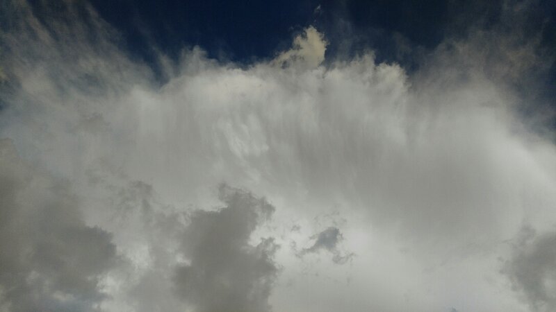
Beautiful anvil from a storm just a few miles east of me. Unfortunately the stupid thing is pretty much stalled out.
Made a pretty rainbow though.
3 likes
Resident Rain Miser
I am a weather hobbyist living 3.5 miles south of Downtown Austin and in no way or fashion should anything I say concerning forecasts be taken seriously. Please check your local NWS for accurate weather forecasting and conditions.
I am a weather hobbyist living 3.5 miles south of Downtown Austin and in no way or fashion should anything I say concerning forecasts be taken seriously. Please check your local NWS for accurate weather forecasting and conditions.
-
1900hurricane

- Category 5

- Posts: 6063
- Age: 34
- Joined: Fri Feb 06, 2015 12:04 pm
- Location: Houston, TX
- Contact:
Re: Texas Summer 2017
bubba hotep wrote:Ntxw wrote:
In other news, the Arctic will anomalously get colder middle of the month. Perhaps that will be a sign of mid summer front intrusions but only an inquiry for the time being.
It would help if we could get a couple of big WPAC systems to recurve and bomb out.
Tell me about it. The WPac is probably my favorite basin to track, but it has been a snoozer out there lately. I'm getting antsy.
2 likes
Contract Meteorologist. TAMU & MSST. Fiercely authentic, one of a kind. We are all given free will, so choose a life meant to be lived. We are the Masters of our own Stories.
Opinions expressed are mine alone.
Follow me on Twitter at @1900hurricane : Read blogs at https://1900hurricane.wordpress.com/
Opinions expressed are mine alone.
Follow me on Twitter at @1900hurricane : Read blogs at https://1900hurricane.wordpress.com/
-
weatherdude1108
- Category 5
- Posts: 4228
- Joined: Tue Dec 13, 2011 1:04 pm
- Location: Northwest Austin/Cedar Park, TX
Re: Texas Summer 2017
gpsnowman wrote:https://youtu.be/tHVpJGXZ21o
Chevy Chase=DFW
Steve Martin, Martin Short=Austin and San Antonio
Love that scene!
0 likes
The preceding post is NOT an official forecast, and should not be used as such. It is only the opinion of the poster and may or may not be backed by sound meteorological data. It is NOT endorsed by any professional institution including storm2k.org. For Official Information please refer to the NHC and NWS products.
-
weatherdude1108
- Category 5
- Posts: 4228
- Joined: Tue Dec 13, 2011 1:04 pm
- Location: Northwest Austin/Cedar Park, TX
Re: Texas Summer 2017
Hoping for some relief! At least this is a small change for us, through Saturday.
0 likes
The preceding post is NOT an official forecast, and should not be used as such. It is only the opinion of the poster and may or may not be backed by sound meteorological data. It is NOT endorsed by any professional institution including storm2k.org. For Official Information please refer to the NHC and NWS products.
Re: Texas Summer 2017
KFWS radar is down (again) but looking at local station radars there is storm activity south of I-30 going on at this hour in the mid cities.
0 likes
The above post and any post by Ntxw is NOT an official forecast and should not be used as such. It is just the opinion of the poster and may or may not be backed by sound meteorological data. It is NOT endorsed by any professional institution including Storm2k. For official information, please refer to NWS products.
Help support Storm2K!
Help support Storm2K!
-
weatherdude1108
- Category 5
- Posts: 4228
- Joined: Tue Dec 13, 2011 1:04 pm
- Location: Northwest Austin/Cedar Park, TX
Re: Texas Summer 2017
Getting tired of the false hopes by the short-term models and discussions. I don't know what or who to believe anymore. Oh wait, I take that back. If they say it will be hot and dry with a 100% chance of misery, then I will believe them.

000
FXUS64 KEWX 071940
AFDEWX
Area Forecast Discussion
National Weather Service Austin/San Antonio TX
240 PM CDT Fri Jul 7 2017
.SHORT TERM (Tonight through Saturday Night)...
Current general weather pattern across the CONUS is a broad trough
across the eastern US with a very strong ridge of high pressure
centered over the four corners region. A weak shear axis remains in
place across south central Texas this afternoon with a weak inverted
trough approaching the Texas Gulf Coast. Currently, isolated showers
and storms are ongoing across the Coastal Plains and slowly drifting
to the northwest. Model soundings this afternoon across the region
depict moderate instability with near moist adiabatic thermal
profiles as well as ample moisture with PWATs on the order of 1.5 to
1.9 inches. Forcing from the approaching weak inverted trough as well
as outflow boundaries and the sea breeze should allow for isolated
to scattered coverage of showers and thunderstorms this afternoon
across most of the region. Given the high PWAT values in place, any
shower or thunderstorm that does form will have the potential to drop
some locally heavy rainfall. Storms should diminish tonight with the
loss of daytime heating.
Overnight tonight, weak southerly flow will keep low-level cloud cover a
bit less than previous nights. This should allow for cooler
temperatures overnight Friday into Saturday morning due to stronger
radiational cooling. Saturday will be similar to today in regards to
both high temperatures as well as another chance for isolated to
scattered afternoon showers and thunderstorms. A weak back-door cold
front will approach the region from the north tomorrow, but is
anticipated to become stationary in the vicinity of the ARKLATEX
region.
&&
.LONG TERM (Sunday through Friday)...
For Sunday, a few showers and thunderstorms will remain possible,
with the greatest chances located across our northeastern counties,
which will be in closest proximity to the stationary front across the
ARKLATEX region and any associated outflow boundaries. Temperatures
on Sunday will again be similar to those of today and Saturday.
The stout ridge of high pressure currently centered over the
southwestern US will gradually move eastward. Increased stability and
the lack of any major forcing will keep rain chances low across the
region for Monday. Slight chances for showers and thunderstorms
return on Tuesday across the coastal plains due to the sea breeze.
Shower and thunderstorm chances increase heading into Wednesday and
Thursday for our southern counties along the coastal plains and the
Rio Grande plains as moisture increases and an inverted trough
approaches from Mexico. High temperatures will range from the low 90s
in the Hill Country to the upper 90s along the Rio Grande for Monday
through Friday.
0 likes
The preceding post is NOT an official forecast, and should not be used as such. It is only the opinion of the poster and may or may not be backed by sound meteorological data. It is NOT endorsed by any professional institution including storm2k.org. For Official Information please refer to the NHC and NWS products.
Re: Texas Summer 2017
weatherdude1108 wrote:Getting tired of the false hopes by the short-term models and discussions. I don't know what or who to believe anymore. Oh wait, I take that back. If they say it will be hot and dry with a 100% chance of misery, then I will believe them.
Yea I know what you mean, the I-35 corridor continues to be sandwiched between areas of scattered storms. I expect we will probably see some storms pop up in the area like last evening but it will again be one of those situations where you have the best chance to get wet if a storm actually develops right overhead.
1 likes
Resident Rain Miser
I am a weather hobbyist living 3.5 miles south of Downtown Austin and in no way or fashion should anything I say concerning forecasts be taken seriously. Please check your local NWS for accurate weather forecasting and conditions.
I am a weather hobbyist living 3.5 miles south of Downtown Austin and in no way or fashion should anything I say concerning forecasts be taken seriously. Please check your local NWS for accurate weather forecasting and conditions.
Re: Texas Summer 2017
1900hurricane wrote:bubba hotep wrote:Ntxw wrote:
In other news, the Arctic will anomalously get colder middle of the month. Perhaps that will be a sign of mid summer front intrusions but only an inquiry for the time being.
It would help if we could get a couple of big WPAC systems to recurve and bomb out.
Tell me about it. The WPac is probably my favorite basin to track, but it has been a snoozer out there lately. I'm getting antsy.
You and me both. It's been a snoozefest across the globe in general. I always count on the WPAC for some amazing satellite shots, at some point it will wake up. EPAC has been doing ok lacking ACE though. Atlantic...well it's the Atlantic...sloppy systems and mostly weak thus far but still early for that basin.
0 likes
The above post and any post by Ntxw is NOT an official forecast and should not be used as such. It is just the opinion of the poster and may or may not be backed by sound meteorological data. It is NOT endorsed by any professional institution including Storm2k. For official information, please refer to NWS products.
Help support Storm2K!
Help support Storm2K!
Re: Texas Summer 2017
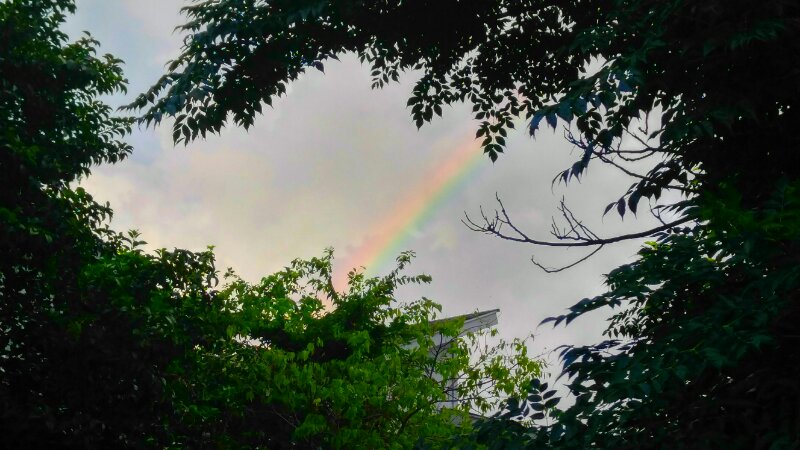
I am happy to report that it is raining in south Austin. Another lovely rainbow as well.
Not a lot of rain but it's better than nothing at all.
Not a lot of rain but it's better than nothing at all.
2 likes
Resident Rain Miser
I am a weather hobbyist living 3.5 miles south of Downtown Austin and in no way or fashion should anything I say concerning forecasts be taken seriously. Please check your local NWS for accurate weather forecasting and conditions.
I am a weather hobbyist living 3.5 miles south of Downtown Austin and in no way or fashion should anything I say concerning forecasts be taken seriously. Please check your local NWS for accurate weather forecasting and conditions.
-
weatherdude1108
- Category 5
- Posts: 4228
- Joined: Tue Dec 13, 2011 1:04 pm
- Location: Northwest Austin/Cedar Park, TX
Re: Texas Summer 2017
JDawg512 wrote:I am happy to report that it is raining in south Austin. Another lovely rainbow as well.
Not a lot of rain but it's better than nothing at all.
We got gusty outflow winds for about 15 minutes from the rain in your part of town. Could have been seabreeze too (?). Cooled it off from a high of 100 on my thermometer, to 89 at 7:55pm. No rain here. Maybe tomorrow(?).
0 likes
The preceding post is NOT an official forecast, and should not be used as such. It is only the opinion of the poster and may or may not be backed by sound meteorological data. It is NOT endorsed by any professional institution including storm2k.org. For Official Information please refer to the NHC and NWS products.
-
Texas Snowman

- Storm2k Moderator

- Posts: 6197
- Joined: Fri Jan 25, 2008 11:29 am
- Location: Denison, Texas
Re: Texas Summer 2017
Ntxw wrote:1900hurricane wrote:bubba hotep wrote:
It would help if we could get a couple of big WPAC systems to recurve and bomb out.
Tell me about it. The WPac is probably my favorite basin to track, but it has been a snoozer out there lately. I'm getting antsy.
You and me both. It's been a snoozefest across the globe in general. I always count on the WPAC for some amazing satellite shots, at some point it will wake up. EPAC has been doing ok lacking ACE though. Atlantic...well it's the Atlantic...sloppy systems and mostly weak thus far but still early for that basin.
Take a look at this....
@philklotzbach -- 0 typhoons so far in 2017 - 6th time on record (since 1950) that NW Pacific has had 0 typhoons thru 7/7. Other yrs: 1977, 83, 95, 98 & 2010
0 likes
The above post and any post by Texas Snowman is NOT an official forecast and should not be used as such. It is just the opinion of the poster and may or may not be backed by sound meteorological data. It is NOT endorsed by any professional institution including storm2k.org. For official information, please refer to NWS products.
-
bubba hotep
- S2K Supporter
- Posts: 6014
- Joined: Wed Dec 28, 2016 1:00 am
- Location: Collin County Texas
Re: Texas Summer 2017
Euro EPS is indicating that the first dry hot stretch is about to start for DFW with temps gradually warming and then peaking in the 100s around mid-month. This also lines up with the last couple of Weeklies but the good news is that it looks like a transient pattern. If the Weeklies are to be believed, the pattern then reverts back to what we have been seeing with temps in the lower 90s with chances of storms. That continues until the end of the run in August.
0 likes
Winter time post are almost exclusively focused on the DFW area.
-
Brent
- S2K Supporter
- Posts: 38755
- Age: 37
- Joined: Sun May 16, 2004 10:30 pm
- Location: Tulsa Oklahoma
- Contact:
Re: Texas Summer 2017
6z GFS had a massive heat wave in the long range with easily record highs, fortunately its beyond 300 hours...
1 likes
#neversummer
-
TexasBreeze
- Tropical Depression

- Posts: 81
- Joined: Mon Jul 07, 2014 12:50 pm
Return to “USA & Caribbean Weather”
Who is online
Users browsing this forum: No registered users and 93 guests