that's what happens with this type of system. Too many get fooled by the convection
ATL: FOUR - Remnants - Discussion
Moderator: S2k Moderators
Re: ATL: FOUR - Tropical Depression - Discussion
that's what happens with this type of system. Too many get fooled by the convection
1 likes


Re: ATL: FOUR - Tropical Depression - Discussion
Yeah convection balls can be deceptive quite often. You'd rather see the spiraling fist of convection to be a more indicative signs of better lower level structure. Clouds have warmed dramatically.
1 likes
The above post and any post by Ntxw is NOT an official forecast and should not be used as such. It is just the opinion of the poster and may or may not be backed by sound meteorological data. It is NOT endorsed by any professional institution including Storm2k. For official information, please refer to NWS products.
Help support Storm2K!

-
SouthDadeFish

- Professional-Met

- Posts: 2835
- Joined: Thu Sep 23, 2010 2:54 pm
- Location: Miami, FL
- Contact:
Re: ATL: FOUR - Tropical Depression - Discussion
If I had to guess, the low and mid-level centers were tilted to the point of no return. You add in some dry air intrusion and you get the rapidly collapsing convection we are seeing now. TD4 is likely toast. Of course it should be watched for possible regeneration at some point, but I don't think that's too likely at this time.
3 likes
-
Aric Dunn
- Category 5

- Posts: 21238
- Age: 43
- Joined: Sun Sep 19, 2004 9:58 pm
- Location: Ready for the Chase.
- Contact:
Re: ATL: FOUR - Tropical Depression - Discussion
Alyono wrote:NDG wrote:Is it gone already?
[img]https://i.imgur.com/wg2w13x.png[/ig]
that's what happens with this type of system. Too many get fooled by the convection
These types? if your implying that there was some sort of inherent difference between this and other developing TC's then I would love a detailed analysis.
fact of the matter is "these types" of systems is a little misleading and implying you were not fooled by it.
if the dry air and SAL were not a factor this system would likely have been well on its way.
It had a well defined circ and plenty of convergence yesterday along with expanding organized convection as well as decreasing mid level easterly shear with upper anticyclone above it ... we all knew the SAL and dry air was coming the question was when ...but since its the tropics you just never can be 100 percent sure. Plenty of systems over the years have survived such environments so its prudent to be on the safe side vs. any absolutes.
The intrusion of the SAL and dry air collapsed the convection rapidly likely disrupting the small circ to a point of no return this morning.
Last edited by Aric Dunn on Thu Jul 06, 2017 9:39 am, edited 1 time in total.
0 likes
Note: If I make a post that is brief. Please refer back to previous posts for the analysis or reasoning. I do not re-write/qoute what my initial post said each time.
If there is nothing before... then just ask
Space & Atmospheric Physicist, Embry-Riddle Aeronautical University,
I believe the sky is falling...
If there is nothing before... then just ask
Space & Atmospheric Physicist, Embry-Riddle Aeronautical University,
I believe the sky is falling...
-
cycloneye

- Admin

- Posts: 148836
- Age: 69
- Joined: Thu Oct 10, 2002 10:54 am
- Location: San Juan, Puerto Rico
Re: ATL: FOUR - Tropical Depression - Discussion
...DEPRESSION POORLY ORGANIZED AND MOVING FASTER...
SUMMARY OF 1100 AM AST...1500 UTC...INFORMATION
-----------------------------------------------
LOCATION...13.2N 42.6W
ABOUT 1260 MI...2030 KM E OF THE LESSER ANTILLES
MAXIMUM SUSTAINED WINDS...30 MPH...45 KM/H
PRESENT MOVEMENT...WNW OR 285 DEGREES AT 21 MPH...33 KM/H
MINIMUM CENTRAL PRESSURE...1008 MB...29.77 INCHES
Tropical Depression Four Discussion Number 3
NWS National Hurricane Center Miami FL AL042017
1100 AM AST Thu Jul 06 2017
A series of microwave images, an earlier NRL WindSAT scatterometer
overpass, and recent ASCAT-B surface wind retrievals indicate that
the surface circulation of the depression has become less organized.
The center remains near the eastern edge of an amorphous blob of
deep convection and is a bit farther south than previously thought.
Enhanced BD-curve infrared imagery also shows that the cloud tops
have warmed considerably during the past 6 hours. The initial
intensity is held at 25 kt for this advisory based on the
deteriorating cloud pattern and a blend of the TAFB and SAB
satellite intensity estimates.
Large-scale dry, sinking air associated with a previous Saharan Air
Layer outbreak continues to be the primary inhibiting factor
affecting the cyclone. Global and ensemble guidance show the system
degenerating into a remnant low or trough in 3 days or less, due to
the aforementioned harsh thermodynamic environment and increasing
moderate westerly shear. The official intensity forecast is
basically an update of the previous advisory and favors the
dynamical models.
The initial motion is estimated to be west-northwestward, or
285/18 kt. The circulation center continues to be difficult to
locate, but the above-mentioned scatterometer pass was helpful in
obtaining the position estimate. The depression is forecast to be
steered by the low- to mid-level flow associated with a building
subtropical ridge situated to its north over the next several days.
The new official forecast is about a half a degree south of the
previous one due to the initial position adjustment. The NHC track
is close to the latest TVCN multi-model consensus.
FORECAST POSITIONS AND MAX WINDS
INIT 06/1500Z 13.2N 42.6W 25 KT 30 MPH
12H 07/0000Z 14.0N 45.3W 30 KT 35 MPH
24H 07/1200Z 15.1N 49.3W 30 KT 35 MPH
36H 08/0000Z 16.2N 52.9W 30 KT 35 MPH
48H 08/1200Z 17.7N 56.6W 25 KT 30 MPH
72H 09/1200Z 20.6N 62.5W 25 KT 30 MPH...POST-TROP/REMNT LOW
96H 10/1200Z 23.0N 67.0W 20 KT 25 MPH...POST-TROP/REMNT LOW
120H 11/1200Z...DISSIPATED
$$
Forecaster Roberts
0 likes
Visit the Caribbean-Central America Weather Thread where you can find at first post web cams,radars
and observations from Caribbean basin members Click Here
and observations from Caribbean basin members Click Here
Re: ATL: FOUR - Tropical Depression - Discussion
48 hours until post-tropical? I'd be shocked if it makes it 24.
5 likes
-
MississippiWx

- S2K Supporter

- Posts: 1716
- Joined: Sat Aug 14, 2010 1:44 pm
- Location: Hattiesburg, Mississippi
Re: ATL: FOUR - Tropical Depression - Discussion
Visible satellite imagery isn't convincing me that the circulation is even closed. Early July is a tough time for tropical waves in the Eastern Atlantic. The activity/strength of waves, so far, has been impressive though. I believe the development of Bret and now TD4 signal that this season will be fairly active in the actual MDR for a change.
1 likes
This post is not an official forecast and should not be used as such. It is just the opinion of MississippiWx and may or may not be backed by sound meteorological data. It is not endorsed by any professional institution including storm2k.org. For Official Information please refer to the NHC and NWS products.
Re: ATL: FOUR - Tropical Depression - Discussion
At least it wasn't (or has yet to be) a name waster. I'm hoping things are dead until mid August.
0 likes
-
TheStormExpert
Re: ATL: FOUR - Tropical Depression - Discussion
I'm thinking this was more than likely a TD several days ago verses yesterday when they started initiating advisories.
1 likes
-
Dean4Storms
- S2K Supporter
- Posts: 6358
- Age: 62
- Joined: Sun Aug 31, 2003 1:01 pm
- Location: Miramar Bch. FL
Re: ATL: FOUR - Tropical Depression - Discussion
Put a fork in it..... I see no sign of a closed LL circulation and even outflows NW Quad! To top it off the Low is now much further SW than earlier forecast.
1 likes
-
tatertawt24
- Category 1

- Posts: 309
- Joined: Wed Oct 24, 2012 12:57 pm
Re: ATL: FOUR - Tropical Depression - Discussion
Season CANCELED! 
4 likes
Personal Forecast Disclaimer:
The posts in this forum are NOT official forecast and should not be used as such. They are just the opinion of the poster and may or may not be backed by sound meteorological data. They are NOT endorsed by any professional institution or storm2k.org. For official information, please refer to the NHC and NWS products.
The posts in this forum are NOT official forecast and should not be used as such. They are just the opinion of the poster and may or may not be backed by sound meteorological data. They are NOT endorsed by any professional institution or storm2k.org. For official information, please refer to the NHC and NWS products.

Re: ATL: FOUR - Tropical Depression - Discussion
I'm just getting a good look at TD 4, it looks just like it's supposed to look to me. A weak TD.
I'm not saying it will not die off in a day or 2 but it does look justified to me. with a few weak T-storms starting to refire. D min folks .
I'm not saying it will not die off in a day or 2 but it does look justified to me. with a few weak T-storms starting to refire. D min folks .
0 likes
The following post is NOT an official forecast and should not be used as such. It is just the opinion of the poster and may or may not be backed by sound meteorological data. It is NOT endorsed by any professional institution including storm2k.org For Official Information please refer to the NHC and NWS products.
-
tropicwatch

- Category 5
- Posts: 3426
- Age: 62
- Joined: Sat Jun 02, 2007 10:01 am
- Location: Panama City Florida
- Contact:
Re: ATL: FOUR - Tropical Depression - Discussion
With the low being further south than expected, moving faster and wind shear currently decreasing in front of it. I am wondering if it will stay far enough ahead of the driest air and last a little longer then expected.
0 likes
Tropicwatch
Agnes 72', Eloise 75, Elena 85', Kate 85', Charley 86', Florence 88', Beryl 94', Dean 95', Erin 95', Opal 95', Earl 98', Georges 98', Ivan 2004', Arlene 2005', Dennis 2005', Ida 2009' Debby 2012' Irma 2017' Michael 2018'
Agnes 72', Eloise 75, Elena 85', Kate 85', Charley 86', Florence 88', Beryl 94', Dean 95', Erin 95', Opal 95', Earl 98', Georges 98', Ivan 2004', Arlene 2005', Dennis 2005', Ida 2009' Debby 2012' Irma 2017' Michael 2018'


Re: ATL: FOUR - Models
UKMET appears to be calling for regeneration down the line:
NEW TROPICAL CYCLONE FORECAST TO DEVELOP AFTER 102 HOURS
FORECAST POSITION AT T+102 : 23.9N 68.9W
LEAD CENTRAL MAXIMUM WIND
VERIFYING TIME TIME POSITION PRESSURE (MB) SPEED (KNOTS)
-------------- ---- -------- ------------- -------------
0000UTC 11.07.2017 108 24.2N 69.6W 1010 35
1200UTC 11.07.2017 120 25.3N 71.7W 1007 41
0000UTC 12.07.2017 132 27.0N 73.8W 1001 44
1200UTC 12.07.2017 144 28.5N 76.4W 994 48
1 likes
-
wxman57

- Moderator-Pro Met

- Posts: 23166
- Age: 68
- Joined: Sat Jun 21, 2003 8:06 pm
- Location: Houston, TX (southwest)
Re: ATL: FOUR - Tropical Depression - Discussion
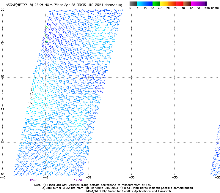
An ASCAT pass from 12Z just came in. Looks like it caught the whole system around 41W-42W. No well-defined LLC is evident. Doesn't qualify for its depression status.
0 likes
-
tolakram
- Admin
- Posts: 20170
- Age: 62
- Joined: Sun Aug 27, 2006 8:23 pm
- Location: Florence, KY (name is Mark)
Re: ATL: FOUR - Tropical Depression - Discussion
Visible (veggie band 3) loop:
http://rammb-slider.cira.colostate.edu/?sat=goes-16&sec=full_disk&x=18944&y=8012&z=4&im=12&ts=1&st=0&et=0&speed=130&motion=loop&map=1&lat=0&p%5B0%5D=2&opacity%5B0%5D=1&hidden%5B0%5D=0&pause=0&slider=-1&hide_controls=0&mouse_draw=0&s=rammb-slider
Explanation of the GOES 16 channels or bands: http://www.goes-r.gov/education/ABI-bands-quick-info.html
1 likes
M a r k
- - - - -
Join us in chat: Storm2K Chatroom Invite. Android and IOS apps also available.
The posts in this forum are NOT official forecasts and should not be used as such. Posts are NOT endorsed by any professional institution or STORM2K.org. For official information and forecasts, please refer to NHC and NWS products.

Re: ATL: FOUR - Tropical Depression - Discussion
Its going to need a few good convective bursts if its going to maintain a low level structure with a pressure gradient. Clear evidence of dry air intrusion this morning, diurnal intensification near sunset is pretty common though.
0 likes
-
Hurricane Andrew

- S2K Supporter
- Posts: 1891
- Age: 27
- Joined: Sun May 23, 2010 2:53 pm
- Location: KS
Re: ATL: FOUR - Models
Of note is that the 12z GFS briefly restrengthens this over the D1-D3 period before opening it up.
1 likes
The Enthusiast
NREMT-AEMT, WX nerd
Irene '11, Sandy '12, Irma '17 (SAR)
"Hard to think we were born to live this way..." -Wage War
-
Aric Dunn
- Category 5
- Posts: 21238
- Age: 43
- Joined: Sun Sep 19, 2004 9:58 pm
- Location: Ready for the Chase.
- Contact:
Re: ATL: FOUR - Tropical Depression - Discussion
Well the GFS is back to keeping it around longer.. kills it east of the bahamas.
1 likes
Note: If I make a post that is brief. Please refer back to previous posts for the analysis or reasoning. I do not re-write/qoute what my initial post said each time.
If there is nothing before... then just ask
Space & Atmospheric Physicist, Embry-Riddle Aeronautical University,
I believe the sky is falling...
If there is nothing before... then just ask
Space & Atmospheric Physicist, Embry-Riddle Aeronautical University,
I believe the sky is falling...
-
weathaguyry

- Category 5
- Posts: 1273
- Age: 22
- Joined: Wed Jun 15, 2016 5:16 am
- Location: Long Island, NY
Re: ATL: FOUR - Tropical Depression - Discussion
It's so strange that in an hour we went from Season Cancelled to huge, dangerous MDR season
2 likes
My posts are only my opinions and NOT official forecasts. For official forecasts, consult the National Hurricane Center or the National Weather Service.
Irene 11', Sandy 12', Fay 20’, Isaias 20’, Elsa 21’, Henri 21’, Ida 21’
Irene 11', Sandy 12', Fay 20’, Isaias 20’, Elsa 21’, Henri 21’, Ida 21’
Who is online
Users browsing this forum: No registered users and 60 guests