ATL: CINDY - Post-Tropical - Discussion
Moderator: S2k Moderators

Re: ATL: THREE- Potential Tropical Cyclone
With the system moving more to the sw, wouldn't that change the overall track ,let's say 48 to 60 hours back toward the n then NE according to the official track ? With the slow down and sw movements? Couldn't it then have time to become more of a threat to become a minor hurricane?
0 likes
-
wxman57

- Moderator-Pro Met

- Posts: 23098
- Age: 68
- Joined: Sat Jun 21, 2003 8:06 pm
- Location: Houston, TX (southwest)
Re: ATL: THREE- Potential Tropical Cyclone
The slower it moves now, the more time for the upper low over the NW Gulf to weaken and move west. That should allow for a more westward track to Texas. StormGeo tweeted one of their ensembles-based "TRAC" graphics. On the bottom left of the graphic are the 3 main models (GFS, CMC, ECMWF) and how many of each ensemble members are included. GFS has 20 + 1 operational, as does the CMC. Euro has 50 ensemble members, 1 control, and 1 operational. Total of 94 possible. Almost all 50 EC members plus the control and operational take it to Texas. GFS is all-in for Louisiana. UKMET has been taking it to Texas, too.

9 likes
-
jlauderdal
- S2K Supporter

- Posts: 7240
- Joined: Wed May 19, 2004 5:46 am
- Location: NE Fort Lauderdale
- Contact:
Re: ATL: THREE- Potential Tropical Cyclone
TheStormExpert wrote:jlauderdal wrote:we are off to a great start with the modeling
Yep! Hard to believe we're in 2017.
interesting to see the gfs and euro consistently see the atmosphere so differently and thus come up with differing solutions even at 72h and thus we cant really be confident with either, gfs gets alot of shade here but it gets its fair share of wins..even as matthew was on the approach to the se coast last year it was touch and go as to which model would provide something we could trust
0 likes
Re: ATL: THREE - Models
If the 18z GFS verifies there will be quite a lot of rain in SE TX. TVCN consensus is very close to the border so it can go either way in terms of which state has official landfall.
0 likes


Re: ATL: THREE- Potential Tropical Cyclone
jlauderdal wrote:TheStormExpert wrote:jlauderdal wrote:we are off to a great start with the modeling
Yep! Hard to believe we're in 2017.
interesting to see the gfs and euro consistently see the atmosphere so differently and thus come up with differing solutions even at 72h and thus we cant really be confident with either, gfs gets alot of shade here but it gets its fair share of wins..even as matthew was on the approach to the se coast last year it was touch and go as to which model would provide something we could trust
One question on the model accuracy--if we can get a single consolidated center form, would that help bring about some sort of consensus with the models? Or are issues in how they're interpreting the steering itself still the cause of the divide?
0 likes
The above post is not official and should not be used as such. It is the opinion of the poster and may or may not be backed by sound meteorological data. It is not endorsed by any professional institution or storm2k.org. For official information, please refer to the NHC and NWS products.
Re: ATL: THREE- Potential Tropical Cyclone
To me it look like the little Jetties got blown out
0 likes
-
tolakram
- Admin

- Posts: 20167
- Age: 62
- Joined: Sun Aug 27, 2006 8:23 pm
- Location: Florence, KY (name is Mark)
Re: ATL: THREE- Potential Tropical Cyclone
TheStormExpert wrote:jlauderdal wrote:we are off to a great start with the modeling
Yep! Hard to believe we're in 2017.
NHC not having an issue forecasting, so far. They also tend not to hug models because the consensus almost always does better. Also keep in mind that both models have been struggling at the 500mb layer, with the GFS actually doing better than the euro every now and then. We discussed this with a few posts and tweets in the global model run thread.
If the GFS gets the upper air right then it will tend to have the better track, in my amateur opinion anyway. Since both are experiencing accuracy errors the blend between the two is the best bet.
Here is the latest free verification graph from Weatherbell. http://models.weatherbell.com/verf/ecmwf_gfs_nh_f120.png
1 likes
M a r k
- - - - -
Join us in chat: Storm2K Chatroom Invite. Android and IOS apps also available.
The posts in this forum are NOT official forecasts and should not be used as such. Posts are NOT endorsed by any professional institution or STORM2K.org. For official information and forecasts, please refer to NHC and NWS products.
Re: ATL: THREE- Potential Tropical Cyclone
You guys realize the models get better year after year, right?
0 likes
Re: ATL: THREE- Potential Tropical Cyclone
Are folks effectively wobble watching a non-even tropical cyclone? Look at the water vapor, wide view, everything is to the east of the system. Landfall won't matter much with this system, and trying to make sense of any center right now is going to drive folks mad.
https://twitter.com/NWSWPC/status/876920644474195968
https://twitter.com/NWSWPC/status/876920644474195968
Last edited by BobHarlem on Mon Jun 19, 2017 7:56 pm, edited 1 time in total.
0 likes

Re: ATL: THREE- Potential Tropical Cyclone
Nice little bitty tstorm popped right over the exposed LLC at sunset. Looks ten times better then earlier today.
1 likes
-
jlauderdal
- S2K Supporter
- Posts: 7240
- Joined: Wed May 19, 2004 5:46 am
- Location: NE Fort Lauderdale
- Contact:
Re: ATL: THREE- Potential Tropical Cyclone
Hammy wrote:jlauderdal wrote:TheStormExpert wrote:Yep! Hard to believe we're in 2017.
interesting to see the gfs and euro consistently see the atmosphere so differently and thus come up with differing solutions even at 72h and thus we cant really be confident with either, gfs gets alot of shade here but it gets its fair share of wins..even as matthew was on the approach to the se coast last year it was touch and go as to which model would provide something we could trust
One question on the model accuracy--if we can get a single consolidated center form, would that help bring about some sort of consensus with the models? Or are issues in how they're interpreting the steering itself still the cause of the divide?
the more developed the system the better the accuracy but getting to that point has proven to be real tricky...intensity forecasting remains a mystery but it continues to improve...overall the models improve with time but its been a very tough road and considering the revisions in the code and the resources invested you would think the two models would be in better agreement early on in the life cycle of these systems
0 likes
-
jlauderdal
- S2K Supporter
- Posts: 7240
- Joined: Wed May 19, 2004 5:46 am
- Location: NE Fort Lauderdale
- Contact:
Re: ATL: THREE- Potential Tropical Cyclone
yes they are getting better but to me the real issue is how differently the solutions are with each run and even within a given model we see some large scale differences run to run...the atmosphere is very dynamic but 6 or 12 hours later we see really large track differences, thats not goodRL3AO wrote:You guys realize the models get better year after year, right?
0 likes

Re: ATL: THREE- Potential Tropical Cyclone
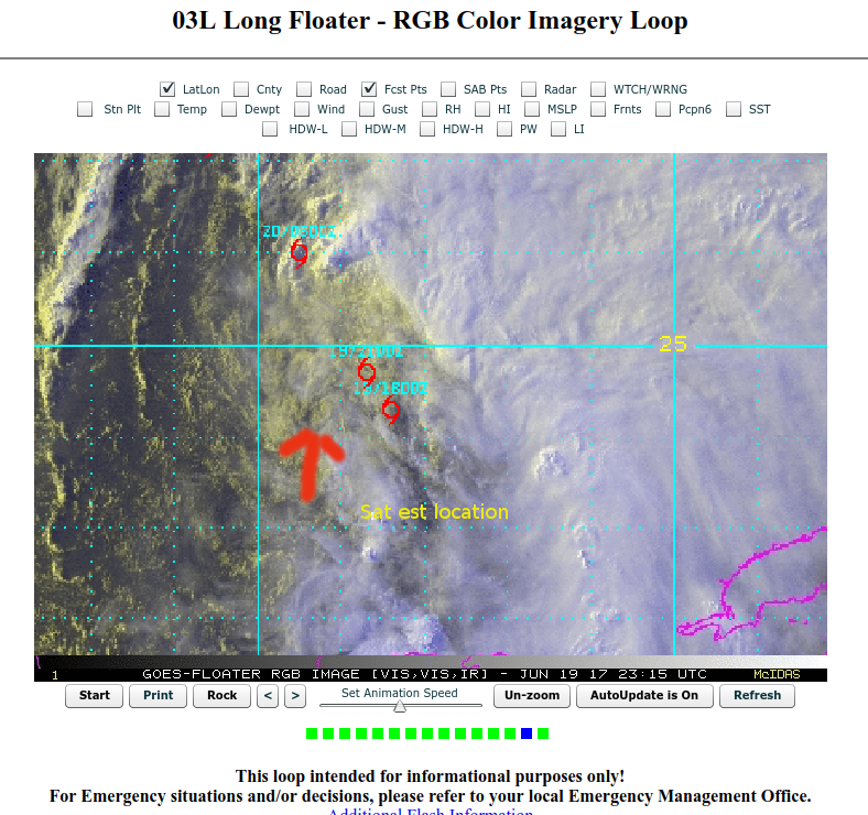
rgb screen shot for estimated center location as of 7:15 pm EDT -imho
a good bit west if i am correct with this location
run the loop here
http://www.ssd.noaa.gov/PS/TROP/floater ... -long.html
click on the forecast pts from the menu
In any event ...we now have a real nice band on the northwest side of the system
Last edited by TJRE on Mon Jun 19, 2017 8:04 pm, edited 1 time in total.
0 likes
-
stormreader
Re: ATL: THREE- Potential Tropical Cyclone
Last edited by tolakram on Mon Jun 19, 2017 8:01 pm, edited 1 time in total.
Reason: removed direct image link, please upload to an image hosting site first
Reason: removed direct image link, please upload to an image hosting site first
1 likes
-
jlauderdal
- S2K Supporter
- Posts: 7240
- Joined: Wed May 19, 2004 5:46 am
- Location: NE Fort Lauderdale
- Contact:
Re: ATL: THREE- Potential Tropical Cyclone
BobHarlem wrote:Are folks effectively wobble watching a non-even tropical cyclone? Look at the water vapor, wide view, everything is to the east of the system. Landfall won't matter much with this system, and trying to make sense of any center right now is going to drive folks mad.
https://twitter.com/NWSWPC/status/876920644474195968
well now that we can get watches and warnings without a named system the wobble watching will become even more intense early on...have fun watching a wobble without a center, haha
0 likes
Re: ATL: THREE - Models
I dug back into the Models thread and found some model runs from 10 days ago that were for tonight or tomorrow morning.
GFS - 10 days ago - Forecast for 6z tomorrow

Euro 10 days ago - Forecast for 0z (aka right about now)

GFS - 10 days ago - Forecast for 6z tomorrow
Euro 10 days ago - Forecast for 0z (aka right about now)
1 likes
Re: ATL: THREE- Potential Tropical Cyclone
jlauderdal wrote:yes they are getting better but to me the real issue is how differently the solutions are with each run and even within a given model we see some large scale differences run to run...the atmosphere is very dynamic but 6 or 12 hours later we see really large track differences, thats not goodRL3AO wrote:You guys realize the models get better year after year, right?
we cant have model agreement...where is the fun with that? We wouldn't have a 2K if the ALL the models were 100% correct....
2 likes
-
tolakram
- Admin
- Posts: 20167
- Age: 62
- Joined: Sun Aug 27, 2006 8:23 pm
- Location: Florence, KY (name is Mark)
Re: ATL: THREE - Models
Horrible performance. 
I wonder how that corresponds to the 500mb verification?
Copy of the freely available verification graphic.

I wonder how that corresponds to the 500mb verification?
Copy of the freely available verification graphic.
2 likes
M a r k
- - - - -
Join us in chat: Storm2K Chatroom Invite. Android and IOS apps also available.
The posts in this forum are NOT official forecasts and should not be used as such. Posts are NOT endorsed by any professional institution or STORM2K.org. For official information and forecasts, please refer to NHC and NWS products.
- - - - -
Join us in chat: Storm2K Chatroom Invite. Android and IOS apps also available.
The posts in this forum are NOT official forecasts and should not be used as such. Posts are NOT endorsed by any professional institution or STORM2K.org. For official information and forecasts, please refer to NHC and NWS products.
Who is online
Users browsing this forum: No registered users and 105 guests