

Those eddies seem to be organizing into a more defined circulation.
Recon getting in there at a good time.
ATL: CINDY - Post-Tropical - Discussion
Moderator: S2k Moderators
Re: ATL: INVEST 93L - Discussion
0 likes
-
PTrackerLA

- Category 5

- Posts: 5281
- Age: 42
- Joined: Thu Oct 10, 2002 8:40 pm
- Location: Lafayette, LA
Re: ATL: INVEST 93L - Discussion
Visible Sat presentation is steadily improving, wouldn't be surprised if we get an upgrade after the HH fly in. I would be surprised if we don't have TS warnings go up at 10pm
http://weather.cod.edu/satrad/exper/?parms=gulf-02-48-1
http://weather.cod.edu/satrad/exper/?parms=gulf-02-48-1
2 likes

Re: ATL: INVEST 93L - Discussion
Latest Cimss 850 vorticity map. much better organized than yesterday.

1 likes
The following post is NOT an official forecast and should not be used as such. It is just the opinion of the poster and may or may not be backed by sound meteorological data. It is NOT endorsed by any professional institution including storm2k.org For Official Information please refer to the NHC and NWS products.
-
cycloneye

- Admin

- Posts: 148836
- Age: 69
- Joined: Thu Oct 10, 2002 10:54 am
- Location: San Juan, Puerto Rico
Re: ATL: INVEST 93L - Recon

0 likes
Visit the Caribbean-Central America Weather Thread where you can find at first post web cams,radars
and observations from Caribbean basin members Click Here
and observations from Caribbean basin members Click Here
Re: ATL: INVEST 93L - Discussion
WTNT22 KNGU 191430
SUBJ/TROPICAL CYCLONE FORMATION ALERT//
REF/A/FLEWEACEN NORFOLK VA/182115Z JUN 17//
AMPN/REF IS TROPICAL CYCLONE FORMATION ALERT (WTNT21 KNGU 182130)//
RMKS/1. FORMATION OF A SIGNIFICANT TROPICAL CYCLONE IS POSSIBLE
WITHIN 100 NM EITHER SIDE OF A LINE FROM 22.8N 88.2W TO 26.9N 88.2W
WITHIN THE NEXT 24 HOURS. AVAILABLE DATA DOES NOT JUSTIFY
ISSUANCE OF NUMBERED TROPICAL CYCLONE WARNINGS AT THIS TIME.
2. AN AREA OF LOW PRESSURE LOCATED NEAR THE NORTHEAST COAST OF
THE YUCATAN PENINSULA CONTINUES TO GENERATE A LARGE AREA OF
SHOWERS AND THUNDERSTORM WITH ASSOCIATED WINDS OF 30-35 KT WELL
EAST OF THE SURFACE CIRCULATION CENTER. FURTHER DEVELOPMENT OF
THE SYSTEM IS EXPECTED AS IT MOVES INTO THE GULF OF MEXICO TODAY.
A TROPICAL OR SUBTROPICAL CYCLONE COULD FORM DURING THE NEXT 24
HOURS AS THE SYSTEM MOVES GENERALLY NORTHWARD AT 8 TO 10 KT IN A
MORE MARGINALLY CONDUCIVE ENVIRONMENT.
3. THIS ALERT WILL BE REISSUED, UPGRADED TO WARNING OR CANCELLED
BY 201430Z.
4. SEE REF A FOR DETAILS ON A TROPICAL CYCLONE FORMATION ALERT
LOCATED NEAR 7.3N 49.4W.//
BT
#0001
NNNN
https://www.nrlmry.navy.mil/atcf_web/do ... 932017.tcf
2 likes

Re: ATL: INVEST 93L - Discussion
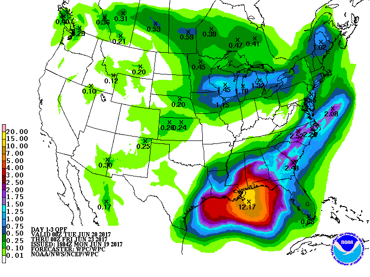
August 2016 was a $10 billion flood disaster.OuterBanker wrote:Was there not massive flooding last year about the same time in the MS and LA delta region?
https://www.climate.gov/news-features/e ... gulf-coast
1 likes

Re: ATL: INVEST 93L - Discussion
For anyone wondering how 93L is interacting with the Upper Level Low to its west, click on the link below and look to the left. You can click on Mid Level Water Vapor or Low level Water Vapor under select a product. This is beyond cool.
Low Level Water Vapor
http://weather.cod.edu/satrad/exper/?parms=gulf-10-48-1
Mid Level Water Vapor
http://weather.cod.edu/satrad/exper/?parms=gulf-09-48-1
Low Level Water Vapor
http://weather.cod.edu/satrad/exper/?parms=gulf-10-48-1
Mid Level Water Vapor
http://weather.cod.edu/satrad/exper/?parms=gulf-09-48-1
2 likes
-
cycloneye
- Admin
- Posts: 148836
- Age: 69
- Joined: Thu Oct 10, 2002 10:54 am
- Location: San Juan, Puerto Rico
Re: ATL: INVEST 93L - Recon
URNT15 KNHC 191944
AF305 01AAA INVEST HDOB 09 20170619
193400 2449N 08952W 3926 07710 0393 -160 -300 223025 025 027 000 00
193430 2447N 08951W 3926 07708 0393 -158 -295 224026 026 027 000 00
193500 2444N 08951W 3926 07708 0393 -160 -305 225026 026 025 001 00
193530 2442N 08951W 3926 07708 0393 -160 -332 224026 026 025 000 00
193600 2439N 08951W 3926 07708 0393 -160 -323 225025 026 023 001 00
193630 2437N 08951W 3926 07708 0393 -160 -418 226025 025 025 000 00
193700 2435N 08951W 3926 07707 0393 -160 -446 225024 025 025 001 00
193730 2435N 08951W 3926 07707 0393 -160 -450 224023 024 027 000 00
193800 2430N 08950W 3923 07712 0392 -160 -439 220023 023 027 000 03
193830 2429N 08948W 3926 07709 0393 -157 -428 216024 025 022 001 00
193900 2428N 08946W 3926 07709 0394 -156 -327 217024 025 025 000 00
193930 2427N 08943W 3926 07711 0396 -159 -403 215022 023 024 000 00
194000 2427N 08940W 3925 07714 0398 -159 -361 213022 022 024 000 00
194030 2426N 08938W 3938 07697 0402 -152 -351 216021 022 023 000 00
194100 2425N 08935W 3922 07726 0406 -145 -337 217022 023 023 000 00
194130 2425N 08933W 3967 07645 0403 -150 -314 217018 023 023 000 00
194200 2424N 08931W 3958 07658 0399 -150 -357 214016 018 023 000 00
194230 2423N 08928W 3960 07652 0397 -150 -318 215016 017 022 000 00
194300 2423N 08926W 3958 07656 0396 -151 -309 214015 016 018 002 03
194330 2424N 08923W 4191 07225 0373 -127 -310 196009 013 /// /// 03
$$
0 likes
Visit the Caribbean-Central America Weather Thread where you can find at first post web cams,radars
and observations from Caribbean basin members Click Here
and observations from Caribbean basin members Click Here
-
cycloneye
- Admin
- Posts: 148836
- Age: 69
- Joined: Thu Oct 10, 2002 10:54 am
- Location: San Juan, Puerto Rico
Re: ATL: INVEST 93L - Recon

0 likes
Visit the Caribbean-Central America Weather Thread where you can find at first post web cams,radars
and observations from Caribbean basin members Click Here
and observations from Caribbean basin members Click Here
-
jasons2k

- Storm2k Executive
- Posts: 8286
- Age: 52
- Joined: Wed Jul 06, 2005 12:32 pm
- Location: The Woodlands, TX
Re: ATL: INVEST 93L - Discussion
davidiowx wrote:jasons wrote:Wonder if this will be another Claudette...I keep looking at that one...
Are you referring to the 1979 one that flooded Houston pretty good?
RE: Claudette -- 2003
Not saying it will happen - still too early for that call, but it's something to watch. Still like the Euro but was surprised it shifted that much in one run.
It will probably remain very disorganized but there MAY be an opportunity for it to try to make a run at intensification before landfall, if the ULL can slingshot it around and then ventilate it. But it has to be in the right spot, in low relative shear, for it to take off.
1 likes
-
tropicwatch

- Category 5
- Posts: 3426
- Age: 62
- Joined: Sat Jun 02, 2007 10:01 am
- Location: Panama City Florida
- Contact:
Re: ATL: INVEST 93L - Recon
How come they are not descending?
0 likes
Tropicwatch
Agnes 72', Eloise 75, Elena 85', Kate 85', Charley 86', Florence 88', Beryl 94', Dean 95', Erin 95', Opal 95', Earl 98', Georges 98', Ivan 2004', Arlene 2005', Dennis 2005', Ida 2009' Debby 2012' Irma 2017' Michael 2018'
Agnes 72', Eloise 75, Elena 85', Kate 85', Charley 86', Florence 88', Beryl 94', Dean 95', Erin 95', Opal 95', Earl 98', Georges 98', Ivan 2004', Arlene 2005', Dennis 2005', Ida 2009' Debby 2012' Irma 2017' Michael 2018'
-
cycloneye
- Admin
- Posts: 148836
- Age: 69
- Joined: Thu Oct 10, 2002 10:54 am
- Location: San Juan, Puerto Rico
Re: ATL: INVEST 93L - Recon

0 likes
Visit the Caribbean-Central America Weather Thread where you can find at first post web cams,radars
and observations from Caribbean basin members Click Here
and observations from Caribbean basin members Click Here
-
jasons2k
- Storm2k Executive
- Posts: 8286
- Age: 52
- Joined: Wed Jul 06, 2005 12:32 pm
- Location: The Woodlands, TX
Re: ATL: INVEST 93L - Discussion
Steve wrote:For anyone wondering how 93L is interacting with the Upper Level Low to its west, click on the link below and look to the left. You can click on Mid Level Water Vapor or Low level Water Vapor under select a product. This is beyond cool.
Low Level Water Vapor
http://weather.cod.edu/satrad/exper/?parms=gulf-10-48-1
Mid Level Water Vapor
http://weather.cod.edu/satrad/exper/?parms=gulf-09-48-1
Yep and still a boatload of dry air out there too, but nobody wants to talk about that
4 likes
Re: ATL: INVEST 93L - Discussion
1 likes
-
cycloneye
- Admin
- Posts: 148836
- Age: 69
- Joined: Thu Oct 10, 2002 10:54 am
- Location: San Juan, Puerto Rico
Re: ATL: INVEST 93L - Recon
Decended and going thru low center.

0 likes
Visit the Caribbean-Central America Weather Thread where you can find at first post web cams,radars
and observations from Caribbean basin members Click Here
and observations from Caribbean basin members Click Here
-
SouthDadeFish

- Professional-Met

- Posts: 2835
- Joined: Thu Sep 23, 2010 2:54 pm
- Location: Miami, FL
- Contact:
Re: ATL: INVEST 93L - Discussion
93L looks much better organized this afternoon, at least in my opinion. Although it doesn't quite look to be a TC yet, the multiple eddies we saw earlier seem to be coalescing into one larger vorticity maximum, which may eventually become the dominant center of circulation. This potential TC will probably be highly asymmetric throughout its lifetime, but the I think the odds of TC formation are near 90% at this time.
4 likes
Re: ATL: INVEST 93L - Discussion
jasons wrote:Steve wrote:For anyone wondering how 93L is interacting with the Upper Level Low to its west, click on the link below and look to the left. You can click on Mid Level Water Vapor or Low level Water Vapor under select a product. This is beyond cool.
Low Level Water Vapor
http://weather.cod.edu/satrad/exper/?parms=gulf-10-48-1
Mid Level Water Vapor
http://weather.cod.edu/satrad/exper/?parms=gulf-09-48-1
Yep and still a boatload of dry air out there too, but nobody wants to talk about that
Some afternoon pop-up thundershowers may fire off over Mexico.
Debris from that would be able to work its way into that dry slot and moisten it up a bit.
2 likes


Re: ATL: INVEST 93L - Discussion
I see at least three mesovorticies spinning about west of the convection.
0 likes
The above post is not official and should not be used as such. It is the opinion of the poster and may or may not be backed by sound meteorological data. It is not endorsed by any professional institution or storm2k.org. For official information, please refer to the NHC and NWS products.
Re: ATL: INVEST 93L - Discussion
Getting a tower firing off in the circulation.
Recon's radar should be able to see it.

Recon's radar should be able to see it.
2 likes
Who is online
Users browsing this forum: No registered users and 34 guests