URNT15 KNHC 191556
AF300 0102A INVEST HDOB 08 20170619
150800 1621N 06311W 4463 06787 0387 -135 -148 146023 024 /// /// 03
150830 1619N 06309W 4463 06784 0383 -135 -148 147023 024 /// /// 03
150900 1617N 06308W 4462 06789 0386 -135 -150 145023 024 /// /// 03
150930 1616N 06306W 4461 06791 0385 -135 -151 148023 023 /// /// 03
151000 1614N 06304W 4461 06791 0385 -135 -152 149022 023 /// /// 03
151030 1613N 06302W 4462 06789 0386 -134 -155 152021 021 /// /// 03
151100 1611N 06300W 4461 06792 0388 -135 -155 154021 022 /// /// 03
151130 1609N 06259W 4461 06795 0389 -134 -155 150021 022 /// /// 03
151200 1608N 06257W 4462 06793 0389 -133 -160 149021 021 /// /// 03
151230 1606N 06255W 4461 06793 0389 -130 -161 149020 021 /// /// 03
151300 1605N 06253W 4461 06793 0388 -130 -161 149020 020 /// /// 03
151330 1603N 06252W 4462 06792 0388 -130 -161 151020 021 /// /// 03
151400 1601N 06250W 4461 06793 0388 -130 -160 154021 021 /// /// 03
151430 1600N 06248W 4462 06792 0387 -132 -166 154022 022 /// /// 03
151500 1558N 06246W 4462 06791 0385 -135 -168 156023 023 /// /// 03
151530 1557N 06245W 4461 06784 0378 -135 -171 156023 024 /// /// 03
151600 1555N 06243W 4461 06780 0375 -133 -176 156024 024 /// /// 03
151630 1553N 06241W 4461 06780 0375 -130 -173 154024 024 /// /// 03
151700 1552N 06239W 4461 06778 0374 -130 -180 155024 025 /// /// 03
151730 1550N 06237W 4462 06778 0373 -130 -182 154024 025 /// /// 03
$$
ATL: BRET - Remnants - Discussion
Moderator: S2k Moderators
-
cycloneye

- Admin

- Posts: 148835
- Age: 69
- Joined: Thu Oct 10, 2002 10:54 am
- Location: San Juan, Puerto Rico
Re: ATL: Potential Tropical Cyclone TWO - Recon
0 likes
Visit the Caribbean-Central America Weather Thread where you can find at first post web cams,radars
and observations from Caribbean basin members Click Here
and observations from Caribbean basin members Click Here
-
cycloneye
- Admin
- Posts: 148835
- Age: 69
- Joined: Thu Oct 10, 2002 10:54 am
- Location: San Juan, Puerto Rico
Re: ATL: Potential Tropical Cyclone TWO - Recon
URNT15 KNHC 191601
AF300 0102A INVEST HDOB 11 20170619
153800 1444N 06124W 4464 06788 0388 -112 -273 135011 012 /// /// 03
153830 1442N 06122W 4464 06786 0386 -110 -237 136013 013 /// /// 03
153900 1440N 06121W 4463 06786 0385 -110 -239 134013 014 /// /// 03
153930 1439N 06119W 4463 06787 0385 -110 -255 133013 014 025 000 03
154000 1437N 06117W 4464 06784 0384 -110 -254 132012 013 028 000 00
154030 1435N 06115W 4464 06782 0382 -110 -246 126013 014 030 000 00
154100 1434N 06113W 4464 06782 0381 -113 -252 128014 015 030 000 00
154130 1432N 06112W 4463 06784 0382 -112 -287 129014 014 030 000 00
154200 1430N 06110W 4463 06787 0385 -117 -309 136011 013 029 000 00
154230 1429N 06108W 4464 06784 0385 -110 -307 129012 013 028 000 00
154300 1427N 06106W 4463 06786 0385 -114 -279 129013 014 031 000 03
154330 1425N 06104W 4463 06788 0387 -121 -285 139010 012 /// /// 03
154400 1424N 06103W 4464 06789 0391 -115 -304 144010 011 /// /// 03
154430 1422N 06101W 4461 06765 0369 -115 -318 142011 011 /// /// 03
154500 1420N 06059W 4463 06789 0384 -119 -322 146011 012 /// /// 03
154530 1419N 06057W 4463 06789 0388 -118 -318 148010 011 /// /// 03
154600 1417N 06055W 4461 06790 0386 -124 -306 164009 010 /// /// 03
154630 1415N 06054W 4463 06788 0386 -125 -265 172009 009 /// /// 03
154700 1414N 06052W 4465 06781 0383 -125 -239 178008 009 /// /// 03
154730 1412N 06050W 4464 06783 0382 -122 -254 177008 008 /// /// 03
$$
;
0 likes
Visit the Caribbean-Central America Weather Thread where you can find at first post web cams,radars
and observations from Caribbean basin members Click Here
and observations from Caribbean basin members Click Here
-
1900hurricane

- Category 5

- Posts: 6063
- Age: 34
- Joined: Fri Feb 06, 2015 12:04 pm
- Location: Houston, TX
- Contact:
Re: ATL: TWO - Potential Tropical Cyclone - Discussion
It can also be seen on the GPM images I have posted above. It actually looked like 02L tried to build a mid-level eye before the circulation became too tilted.
1 likes
Contract Meteorologist. TAMU & MSST. Fiercely authentic, one of a kind. We are all given free will, so choose a life meant to be lived. We are the Masters of our own Stories.
Opinions expressed are mine alone.
Follow me on Twitter at @1900hurricane : Read blogs at https://1900hurricane.wordpress.com/
Opinions expressed are mine alone.
Follow me on Twitter at @1900hurricane : Read blogs at https://1900hurricane.wordpress.com/
-
Bocadude85

- Category 5
- Posts: 2990
- Age: 39
- Joined: Mon Apr 18, 2005 2:20 pm
- Location: Honolulu,Hi
Re: ATL: Potential Tropical Cyclone TWO - Models
TheStormExpert wrote:12z GFS now down to 994mb in 18hrs. before weakening.

That's one of the strongest runs yet from the GFS, I'm not sure it will materialize if 02L doesn't start gaining a little latitude.
1 likes
-
cycloneye
- Admin
- Posts: 148835
- Age: 69
- Joined: Thu Oct 10, 2002 10:54 am
- Location: San Juan, Puerto Rico
Re: ATL: Potential Tropical Cyclone TWO - Recon

1 likes
Visit the Caribbean-Central America Weather Thread where you can find at first post web cams,radars
and observations from Caribbean basin members Click Here
and observations from Caribbean basin members Click Here
-
TheStormExpert
Re: ATL: Potential Tropical Cyclone TWO - Models
Bocadude85 wrote:TheStormExpert wrote:12z GFS now down to 994mb in 18hrs. before weakening.
That's one of the strongest runs yet from the GFS, I'm not sure it will materialize if 02L doesn't start gaining a little latitude.
I'm not to sure about that intensity, but I believe it is moving WNW currently.
0 likes
-
Aric Dunn
- Category 5
- Posts: 21238
- Age: 43
- Joined: Sun Sep 19, 2004 9:58 pm
- Location: Ready for the Chase.
- Contact:
Re: ATL: TWO - Potential Tropical Cyclone - Discussion
moving right along.. image about an hour ago.. looks like pretty good beginnings of banding going on. likely still not very well stacked. but its very likely a TS

1 likes
Note: If I make a post that is brief. Please refer back to previous posts for the analysis or reasoning. I do not re-write/qoute what my initial post said each time.
If there is nothing before... then just ask
Space & Atmospheric Physicist, Embry-Riddle Aeronautical University,
I believe the sky is falling...
If there is nothing before... then just ask
Space & Atmospheric Physicist, Embry-Riddle Aeronautical University,
I believe the sky is falling...
-
cycloneye
- Admin
- Posts: 148835
- Age: 69
- Joined: Thu Oct 10, 2002 10:54 am
- Location: San Juan, Puerto Rico
Re: ATL: Potential Tropical Cyclone TWO - Recon
URNT15 KNHC 191608
AF300 0102A INVEST HDOB 13 20170619
155800 1337N 06012W 4463 06790 0386 -120 -189 145016 016 029 000 00
155830 1335N 06010W 4463 06790 0386 -120 -205 136017 017 029 000 03
155900 1333N 06009W 4463 06789 0386 -123 -235 131017 017 029 000 00
155930 1332N 06007W 4464 06784 0386 -125 -215 129017 017 029 000 03
160000 1330N 06005W 4464 06786 0385 -125 -198 131018 018 029 000 00
160030 1329N 06003W 4464 06788 0386 -125 -199 131017 018 029 000 03
160100 1327N 06002W 4464 06789 0387 -126 -193 130018 018 029 000 00
160130 1325N 06000W 4463 06783 0385 -125 -188 128017 018 029 000 00
160200 1324N 05958W 4464 06785 0386 -125 -200 127017 017 029 000 00
160230 1322N 05956W 4464 06781 0385 -125 -200 131018 018 030 000 00
160300 1320N 05955W 4463 06783 0384 -122 -194 132017 017 029 000 00
160330 1319N 05953W 4463 06786 0385 -120 -201 133016 017 028 000 00
160400 1317N 05951W 4463 06782 0384 -120 -216 135016 017 029 000 03
160430 1315N 05949W 4463 06788 0385 -116 -231 137016 016 030 000 00
160500 1314N 05948W 4464 06783 0384 -118 -236 137018 019 031 000 00
160530 1312N 05946W 4464 06780 0382 -120 -218 138019 020 031 000 00
160600 1310N 05944W 4463 06789 0382 -120 -201 140019 020 031 000 03
160630 1309N 05942W 4464 06760 0361 -120 -191 139019 020 031 000 03
160700 1307N 05941W 4463 06762 0360 -116 -198 136019 019 033 000 03
160730 1306N 05939W 4464 06761 0361 -115 -212 136021 022 036 000 03
$$
;
0 likes
Visit the Caribbean-Central America Weather Thread where you can find at first post web cams,radars
and observations from Caribbean basin members Click Here
and observations from Caribbean basin members Click Here

Re: ATL: TWO - Potential Tropical Cyclone - Discussion
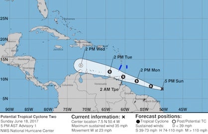
I don't know if anybody mentioned this but looking at the NHC map it no longer weakens to a depression. Maybe it survives and finds a better environment in the WCARB.

Yesterday:
Yesterday:
1 likes
The following post is NOT an official forecast and should not be used as such. It is just the opinion of the poster and may or may not be backed by sound meteorological data. It is NOT endorsed by any professional institution including storm2k.org For Official Information please refer to the NHC and NWS products.
-
cycloneye
- Admin
- Posts: 148835
- Age: 69
- Joined: Thu Oct 10, 2002 10:54 am
- Location: San Juan, Puerto Rico
Re: ATL: Potential Tropical Cyclone TWO - Recon

0 likes
Visit the Caribbean-Central America Weather Thread where you can find at first post web cams,radars
and observations from Caribbean basin members Click Here
and observations from Caribbean basin members Click Here

Re: ATL: TWO - Potential Tropical Cyclone - Discussion
blp wrote:I don't know if anybody mentioned this but looking at the NHC map it no longer weakens to a depression. Maybe it survives and finds a better environment in the WCARB.
[img]http://i.imgur.com/rrRLi8U.pngimg]
Yesterday:
[img]https://s.w-x.co/wu/track-ptc1-21Z-6.18.17-418px.jpg/img]
They still have it dissipating after 48 hours. It doesn't survive 72 hours to have anything plotted on the map.
1 likes
-
Aric Dunn
- Category 5
- Posts: 21238
- Age: 43
- Joined: Sun Sep 19, 2004 9:58 pm
- Location: Ready for the Chase.
- Contact:
Re: ATL: TWO - Potential Tropical Cyclone - Discussion
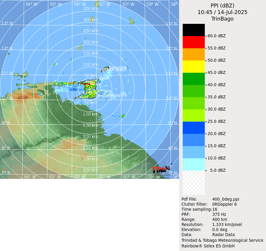
Also pretty easy to see on radar now.
1 likes
Note: If I make a post that is brief. Please refer back to previous posts for the analysis or reasoning. I do not re-write/qoute what my initial post said each time.
If there is nothing before... then just ask
Space & Atmospheric Physicist, Embry-Riddle Aeronautical University,
I believe the sky is falling...
If there is nothing before... then just ask
Space & Atmospheric Physicist, Embry-Riddle Aeronautical University,
I believe the sky is falling...
-
weathaguyry

- Category 5
- Posts: 1273
- Age: 22
- Joined: Wed Jun 15, 2016 5:16 am
- Location: Long Island, NY
Re: ATL: TWO - Potential Tropical Cyclone - Discussion
Maybe it can find a good environment for a little while before shear ramps up

0 likes
My posts are only my opinions and NOT official forecasts. For official forecasts, consult the National Hurricane Center or the National Weather Service.
Irene 11', Sandy 12', Fay 20’, Isaias 20’, Elsa 21’, Henri 21’, Ida 21’
Irene 11', Sandy 12', Fay 20’, Isaias 20’, Elsa 21’, Henri 21’, Ida 21’
-
cycloneye
- Admin
- Posts: 148835
- Age: 69
- Joined: Thu Oct 10, 2002 10:54 am
- Location: San Juan, Puerto Rico
Re: ATL: TWO - Potential Tropical Cyclone - Discussion
Follow the recon mission here: viewtopic.php?f=59&t=118773&p=2583953#p2583953
0 likes
Visit the Caribbean-Central America Weather Thread where you can find at first post web cams,radars
and observations from Caribbean basin members Click Here
and observations from Caribbean basin members Click Here
-
cycloneye
- Admin
- Posts: 148835
- Age: 69
- Joined: Thu Oct 10, 2002 10:54 am
- Location: San Juan, Puerto Rico
Re: ATL: Potential Tropical Cyclone TWO - Recon
URNT15 KNHC 191621
AF300 0102A INVEST HDOB 14 20170619
160800 1304N 05937W 4463 06762 0360 -117 -186 136021 022 /// /// 03
160830 1302N 05936W 4463 06762 0360 -118 -184 135019 020 /// /// 03
160900 1301N 05934W 4463 06762 0361 -117 -190 131019 021 /// /// 03
160930 1259N 05932W 4464 06760 0361 -119 -181 136020 021 /// /// 03
161000 1257N 05930W 4464 06761 0361 -116 -187 136020 020 /// /// 03
161030 1256N 05929W 4464 06761 0360 -115 -184 137020 020 /// /// 03
161100 1254N 05927W 4464 06761 0360 -115 -194 137018 019 /// /// 03
161130 1253N 05925W 4463 06762 0360 -115 -194 138017 018 /// /// 03
161200 1251N 05923W 4464 06760 0359 -115 -176 138017 018 /// /// 03
161230 1249N 05922W 4463 06760 0359 -115 -186 137018 019 /// /// 03
161300 1248N 05920W 4464 06760 0359 -115 -181 136019 020 031 000 00
161330 1246N 05918W 4463 06761 0358 -115 -171 133020 021 032 000 00
161400 1244N 05916W 4464 06756 0357 -115 -173 131021 022 032 000 00
161430 1243N 05915W 4463 06760 0358 -113 -173 135022 022 032 000 03
161500 1241N 05913W 4463 06758 0357 -112 -175 134022 023 033 000 00
161530 1239N 05911W 4464 06757 0357 -114 -180 135023 024 033 000 00
161600 1238N 05910W 4463 06758 0355 -108 -181 141021 023 035 000 03
161630 1236N 05908W 4464 06755 0355 -105 -192 149017 020 035 000 00
161700 1235N 05906W 4463 06756 0356 -107 -204 144018 021 036 000 00
161730 1233N 05904W 4467 06752 0355 -112 -156 128023 024 035 000 00
$$
;
0 likes
Visit the Caribbean-Central America Weather Thread where you can find at first post web cams,radars
and observations from Caribbean basin members Click Here
and observations from Caribbean basin members Click Here
-
floridasun78
- Category 5
- Posts: 3755
- Joined: Sun May 17, 2009 10:16 pm
- Location: miami fl
Re: ATL: TWO - Potential Tropical Cyclone - Discussion
weathaguyry wrote:Maybe it can find a good environment for a little while before shear ramps up
if look at map see wind-shear weakling on eastern Caribbean If look botton of decreasing (-----) on map
1 likes
-
cycloneye
- Admin
- Posts: 148835
- Age: 69
- Joined: Thu Oct 10, 2002 10:54 am
- Location: San Juan, Puerto Rico
Re: ATL: Potential Tropical Cyclone TWO - Recon
Who wants to continue the posting of data?
0 likes
Visit the Caribbean-Central America Weather Thread where you can find at first post web cams,radars
and observations from Caribbean basin members Click Here
and observations from Caribbean basin members Click Here
-
weathaguyry
- Category 5
- Posts: 1273
- Age: 22
- Joined: Wed Jun 15, 2016 5:16 am
- Location: Long Island, NY
Re: ATL: Potential Tropical Cyclone TWO - Recon
cycloneye wrote:Who wants to continue the posting of data?
I can
1 likes
My posts are only my opinions and NOT official forecasts. For official forecasts, consult the National Hurricane Center or the National Weather Service.
Irene 11', Sandy 12', Fay 20’, Isaias 20’, Elsa 21’, Henri 21’, Ida 21’
Irene 11', Sandy 12', Fay 20’, Isaias 20’, Elsa 21’, Henri 21’, Ida 21’
-
weathaguyry
- Category 5
- Posts: 1273
- Age: 22
- Joined: Wed Jun 15, 2016 5:16 am
- Location: Long Island, NY
Re: ATL: Potential Tropical Cyclone TWO - Recon
163730 1111N 05826W 4470 06739 0346 -106 //// 106025 027 034 001 01
163800 1109N 05825W 4461 06752 0345 -110 //// 106026 027 033 001 01
163830 1107N 05825W 4463 06745 0344 -110 //// 104024 025 033 002 01
163900 1104N 05824W 4463 06745 0344 -110 //// 102024 025 034 000 05
163930 1102N 05824W 4464 06743 0343 -112 //// 106023 024 032 000 01
164000 1100N 05823W 4463 06745 0343 -115 //// 112024 025 031 000 01
164030 1058N 05822W 4464 06743 0342 -114 //// 114024 025 032 000 01
164100 1056N 05822W 4463 06742 0341 -113 -117 107023 025 033 000 05
164130 1053N 05821W 4463 06743 0342 -109 -117 102023 024 033 000 00
164200 1051N 05821W 4463 06746 0345 -112 -113 102025 027 033 000 01
164230 1049N 05820W 4463 06747 0346 -113 -122 099027 027 034 000 03
164300 1047N 05819W 4463 06747 0346 -114 -126 097028 028 034 000 00
164330 1045N 05819W 4464 06746 0346 -113 -124 098030 031 035 000 00
164400 1043N 05818W 4463 06747 0345 -115 -124 096030 031 035 000 00
164430 1040N 05818W 4464 06743 0344 -115 -123 095031 031 035 000 00
164500 1038N 05817W 4463 06745 0344 -115 //// 096031 031 034 000 05
164530 1036N 05816W 4475 06731 0346 -111 -113 097031 032 035 000 00
164600 1034N 05816W 4612 06499 0338 -097 -106 094032 033 035 000 05
164630 1032N 05815W 4738 06292 0326 -082 //// 094032 033 036 000 01
164700 1030N 05815W 4859 06100 0313 -072 -077 096034 036 038 001 00
164730 1028N 05814W 5003 05868 0302 -062 -068 100037 038 038 000 00
0 likes
My posts are only my opinions and NOT official forecasts. For official forecasts, consult the National Hurricane Center or the National Weather Service.
Irene 11', Sandy 12', Fay 20’, Isaias 20’, Elsa 21’, Henri 21’, Ida 21’
Irene 11', Sandy 12', Fay 20’, Isaias 20’, Elsa 21’, Henri 21’, Ida 21’
Re: ATL: TWO - Potential Tropical Cyclone - Discussion
floridasun78 wrote:weathaguyry wrote:Maybe it can find a good environment for a little while before shear ramps up
[img]http://tropic.ssec.wisc.edu/real-time/atlantic/winds/wg8sht.GIF[ /img]
if look at map see wind-shear weakling on eastern Caribbean If look botton of decreasing (-----) on map
The trough (the U-shaped region of high shear over the Caribbean) is slowly retreating westward. The decreasing shear over the eastern Caribbean is where the upper-level trough axis is. The trough won't retreat quickly enough for 02L to not be destroyed in a couple of days.
1 likes
Who is online
Users browsing this forum: No registered users and 74 guests