
ATL: CINDY - Post-Tropical - Discussion
Moderator: S2k Moderators
-
Kingarabian

- S2K Supporter

- Posts: 16321
- Joined: Sat Aug 08, 2009 3:06 am
- Location: Honolulu, Hawaii
Re: ATL: INVEST 93L - Models
Then I should say back west compared to the 00z run, since the 00z run is more east.
0 likes
RIP Kobe Bryant


Re: ATL: INVEST 93L - Discussion
Levi did a great job in his latest update explaining how the low will form north of the Yucatan.
Looks like that is exactly what will happen.
I learned something.
Spot on Levi.
Looks like that is exactly what will happen.
I learned something.
Spot on Levi.
0 likes
-
wxman57

- Moderator-Pro Met

- Posts: 23166
- Age: 68
- Joined: Sat Jun 21, 2003 8:06 pm
- Location: Houston, TX (southwest)
Re: ATL: INVEST 93L - Discussion
I'm still not seeing any Florida threat out of this system. Looks like it's heading west to Texas as per EC/UKMET. Not very strong or well-organized. It will likely be forgotten at the end of the season, unless it caused major flooding.
3 likes
Re: ATL: INVEST 93L - Discussion
wxman57 wrote:I'm still not seeing any Florida threat out of this system. Looks like it's heading west to Texas as per EC/UKMET. Not very strong or well-organized. It will likely be forgotten at the end of the season, unless it caused major flooding.
I hope that by now there's nobody left that still thinks this is a FL threat just like those who thought this was heading towards MX
1 likes
-
weathaguyry

- Category 5

- Posts: 1273
- Age: 22
- Joined: Wed Jun 15, 2016 5:16 am
- Location: Long Island, NY
Re: ATL: INVEST 93L - Discussion
NDG wrote:wxman57 wrote:I'm still not seeing any Florida threat out of this system. Looks like it's heading west to Texas as per EC/UKMET. Not very strong or well-organized. It will likely be forgotten at the end of the season, unless it caused major flooding.
I hope that by now there's nobody left that still thinks this is a FL threat just like those who thought this was heading towards MX
The people who thought this would be in Northern Mexico, close to the TX/MX border weren't too far off, but the people who thought this would get buried in the BOC, close to CA, were wrong, but then again who knows what will happen
0 likes
My posts are only my opinions and NOT official forecasts. For official forecasts, consult the National Hurricane Center or the National Weather Service.
Irene 11', Sandy 12', Fay 20’, Isaias 20’, Elsa 21’, Henri 21’, Ida 21’
Irene 11', Sandy 12', Fay 20’, Isaias 20’, Elsa 21’, Henri 21’, Ida 21’
Re: ATL: INVEST 93L - Discussion
GOES 16 6.95 um is showing a strong hook on the trough in the NW GOM.
https://weather.msfc.nasa.gov/cgi-bin/s ... loc=#image
Can see it also on 200 mb vorticity, a very strong PV signature.
http://tropic.ssec.wisc.edu/real-time/w ... oom=&time=
This is definelty close enough for a Fujiwhara interaction that will hook 93L into a NW turn into the GOM
COAMPS is showing this as well with a near-Houston landfall.
https://www.nrlmry.navy.mil/coamps-web/ ... 50&tau=999
Interaction will be "lopsided" in the vertical vorticity column, meaning 93L will likely not stack up.
Given that and the dry slot it may traverse in the GOM, it is likely not to be much more than a strong TS or low-level CAT 1 at best.
However, a random, strong hot-tower or two could realign it and strengthen it more than expected.
1 likes
Re: ATL: INVEST 93L - Discussion
Looking at surface observation from the Yucatan and first visible hr satellite loop the low pressure center is north of the YP. IMO.
Not the best looking system this morning.
Not the best looking system this morning.
1 likes
-
cycloneye

- Admin

- Posts: 148836
- Age: 69
- Joined: Thu Oct 10, 2002 10:54 am
- Location: San Juan, Puerto Rico
Re: ATL: INVEST 93L - Discussion
8 AM TWO 80%-90%.
A broad area of low pressure extending from the Yucatan Peninsula
across adjacent portions of the southeastern Gulf of Mexico
continues to produce a large area of disorganized showers and
thunderstorms along with winds to gale force several hundred miles
east and northeast of the estimated center. While the low still
lacks a well-defined center of circulation, gradual development is
expected today through Tuesday while it moves across the southern
and central Gulf of Mexico, and a tropical or subtropical cyclone is
likely to form. Regardless of development, heavy rains are expected
to continue over portions of Central America, the Yucatan Peninsula,
the Cayman Islands, and western Cuba during the next day or two. An
Air Force Reserve Hurricane Hunter aircraft is scheduled to
investigate this system later today, if necessary. For more
information on this system, please see the High Seas Forecasts
issued by the National Weather Service.
* Formation chance through 48 hours...high...80 percent.
* Formation chance through 5 days...high...90 percent.
0 likes
Visit the Caribbean-Central America Weather Thread where you can find at first post web cams,radars
and observations from Caribbean basin members Click Here
and observations from Caribbean basin members Click Here
-
Aric Dunn
- Category 5
- Posts: 21238
- Age: 43
- Joined: Sun Sep 19, 2004 9:58 pm
- Location: Ready for the Chase.
- Contact:
Re: ATL: INVEST 93L - Discussion
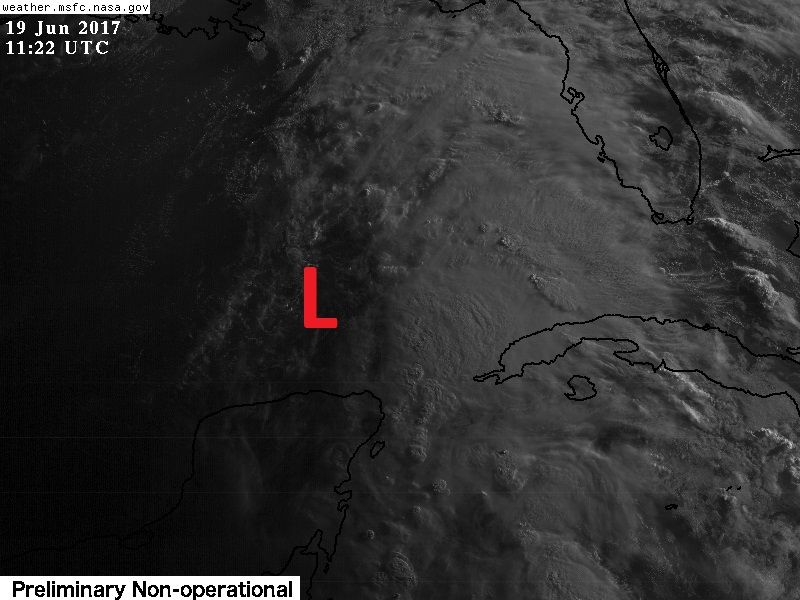
look what we have just north of the Yucatan ..

1 likes
Note: If I make a post that is brief. Please refer back to previous posts for the analysis or reasoning. I do not re-write/qoute what my initial post said each time.
If there is nothing before... then just ask
Space & Atmospheric Physicist, Embry-Riddle Aeronautical University,
I believe the sky is falling...
If there is nothing before... then just ask
Space & Atmospheric Physicist, Embry-Riddle Aeronautical University,
I believe the sky is falling...
-
srainhoutx

- S2K Supporter
- Posts: 6919
- Age: 68
- Joined: Sun Jan 14, 2007 11:34 am
- Location: Haywood County, NC
- Contact:
Re: ATL: INVEST 93L - Discussion
Monday morning briefing from Jeff:
Tropical storm likely in the Gulf of Mexico this week…a threat to the US Gulf coast
Discussion:
Disorganized tropical wave axis across the eastern Yucatan into the southern Gulf of Mexico this morning has shown little evidence of becoming any better defined overnight. Surface wind analysis shows more of an elongated trough axis than any sort of surface low. Deep convection has been firing across the western Caribbean waters much of the night, but this is well east of the sharp trough axis. The trough has become slightly better defined near the northern coast of the Yucatan where models have been suggesting for days a surface low will form.
Additionally, the upper trough over the NW Gulf of Mexico continues to produce strong shear across the central Gulf and the northern portions of the tropical wave axis. Deep tropical moisture is quickly advancing northward across the eastern gulf.
Track:
While it has been most frustrating watching the most reliable global weather forecasting computer models there is a slow but steady growing consensus on the track of this system. The complicated setup of steering flow across the Gulf of Mexico is the reason for the large spread in the model guidance with each model having its particular favored choice of which atmospheric circulation will ultimately drive the system toward the US Gulf coast. These factors include:
1) A trough over the northern Gulf coast which is fracturing and will form a weakness or upper level low over the western Gulf
2) Building sub-tropical high pressure ridges from both the SW US and the SW Atlantic.
3) A trough of low pressure over the Great Lakes
It is becoming more defined that the dominant steering pattern will evolve around the fracturing and development of an upper level low over the western Gulf of Mexico over the next 24-48 hours with 93L moving northward along the eastern flank of this large scale circulation. In fact there is enough evidence in the model guidance to suggest these two circulations actually interact more and more creating varied solutions. There is general agreement that the sharp trough axis will drift WNW today with a surface low likely forming somewhere within the northern portion of this axis and moving generally N to NNW along the eastern side of the developing upper trough over the western Gulf. This motion will continue on Tuesday as the system moves into the central Gulf of Mexico, but track guidance then becomes split with the GFS tracking 93L NNW toward southern Louisiana while the ECMWF turns 93L almost due west and toward the middle TX coast by Thursday. The CMC is down the middle tracking the system toward the upper TX coast by Thursday. The key to the track will be how much influence the developing upper trough over the western Gulf has over the developing surface low.
There is enough consensus this morning to suggest that the threat for a landfalling tropical storm on the Texas/Louisiana coasts sometime from late Wednesday into late Thursday is likely.
Intensity:
93L is highly disorganized and the atmospheric setup in the Gulf of Mexico does not look very favorable for intensification. Tropical cyclones can and at times do interact with upper level troughs like the one which is forecast to be in the western Gulf this week. The surface low on the eastern side of the large scale trough must find its way into the favorable venting portion of the trough or shear will have a negative effect on the surface low. What is interesting is that several of the global and now meso scale models show such a shearing environment across the central Gulf and then actually show decent upper air conditions as the system nears the coast. Both the high resolution NAM and CMC show a fairly symmetrical system in their 54-84 hours time periods while the GFS and ECMWF show a much more elongated and lopsided presentation.
Several Gulf of Mexico tropical systems have formed in this manner and the end result is almost always a flood event somewhere along and east of the track of a broad ill defined center.
Impacts:
Will raise seas on Tuesday to 3-4 feet across our 20-60nm waters with NHC forecasting 8-12 feet approaching our outer waters on Wednesday. Increasing tides will be possible as early as Wednesday, but will keep them below 2.0 feet total water for now. Addition of larger easterly swell onto the coast on Wednesday will likely start to pile up the water to some degree. It would seem that rain chances need to be raised to at least 50% late Wednesday and this may need additional adjusting upward. Don’t want to get much more specific with impacts at this point until either there is some guidance from NHC or the model track solutions firm up more. A track of the system toward Louisiana would result in a fairly dry and hot forecast for our area while a track toward the TX coast would result in a certainly more wet forecast.
Significant forecast changes may be required for the Wed-Fri period.
Persons along the TX/LA coasts should closely monitor the progress of 93L and be prepared for adverse conditions to potentially begin impacting the coast as early as midday Wednesday.
0 likes
Carla/Alicia/Jerry(In The Eye)/Michelle/Charley/Ivan/Dennis/Katrina/Rita/Wilma/Ike/Harvey
Member: National Weather Association
Wx Infinity Forums
http://wxinfinity.com/index.php
Facebook.com/WeatherInfinity
Twitter @WeatherInfinity
Member: National Weather Association
Wx Infinity Forums
http://wxinfinity.com/index.php
Facebook.com/WeatherInfinity
Twitter @WeatherInfinity
Re: ATL: INVEST 93L - Discussion
Aric Dunn wrote:look what we have just north of the Yucatan ..
Yeap, that's exactly where I placed the L on my image but looking at the loop it looks to be just an eddy rotating around a large circulation, there's another one moving south right on the coast of the YP.
0 likes
-
SFLcane

- S2K Supporter
- Posts: 10281
- Age: 48
- Joined: Sat Jun 05, 2010 1:44 pm
- Location: Lake Worth Florida
Re: ATL: INVEST 93L - Discussion
Typical June large sheared mess here I just don't see any significant development regardless flooding rains main threat.
0 likes


Re: ATL: INVEST 93L - Discussion
Visible loop this morning

0 likes
The above post and any post by Ntxw is NOT an official forecast and should not be used as such. It is just the opinion of the poster and may or may not be backed by sound meteorological data. It is NOT endorsed by any professional institution including Storm2k. For official information, please refer to NWS products.
Help support Storm2K!

-
Frank P
- S2K Supporter
- Posts: 2779
- Joined: Fri Aug 29, 2003 10:52 am
- Location: Biloxi Beach, Ms
- Contact:
Re: ATL: INVEST 93L - Discussion
NDG wrote:Aric Dunn wrote:look what we have just north of the Yucatan ..
Yeap, that's exactly where I placed the L on my image but looking at the loop it looks to be just an eddy rotating around a large circulation, there's another one moving south right on the coast of the YP.
Looks like an eddy to me too, moving west and then wsw as it pinwheels around the broad circulation....
1 likes

Re: ATL: INVEST 93L - Discussion
SSD has a 1005 mb low over the north-central portion of the Yucatan peninsula. Appears to me that low pressure is probably elongated north to south along the trough axis now. Still a long ways to go to be organized.
1 likes

Re: ATL: INVEST 93L - Discussion
My first naked swirl Alert of the season. 

We'll have to watch and see if this becomes the main center of this mess as time goes on.
We'll have to watch and see if this becomes the main center of this mess as time goes on.
1 likes
The following post is NOT an official forecast and should not be used as such. It is just the opinion of the poster and may or may not be backed by sound meteorological data. It is NOT endorsed by any professional institution including storm2k.org For Official Information please refer to the NHC and NWS products.
-
Aric Dunn
- Category 5
- Posts: 21238
- Age: 43
- Joined: Sun Sep 19, 2004 9:58 pm
- Location: Ready for the Chase.
- Contact:
Re: ATL: INVEST 93L - Discussion
Frank P wrote:NDG wrote:Aric Dunn wrote:look what we have just north of the Yucatan ..
Yeap, that's exactly where I placed the L on my image but looking at the loop it looks to be just an eddy rotating around a large circulation, there's another one moving south right on the coast of the YP.
Looks like an eddy to me too, moving west and then wsw as it pinwheels around the broad circulation....
Yes but compared to.yesterday the low levels are mich better defined.
1 likes
Note: If I make a post that is brief. Please refer back to previous posts for the analysis or reasoning. I do not re-write/qoute what my initial post said each time.
If there is nothing before... then just ask
Space & Atmospheric Physicist, Embry-Riddle Aeronautical University,
I believe the sky is falling...
If there is nothing before... then just ask
Space & Atmospheric Physicist, Embry-Riddle Aeronautical University,
I believe the sky is falling...

Re: ATL: INVEST 93L - Models
The one day I had to drop my car off for a repair and ride my bike home we've got a huge rain band offshore. Anyway, this looks like it will stay west of me as far as impact.
0 likes
Who is online
Users browsing this forum: No registered users and 75 guests