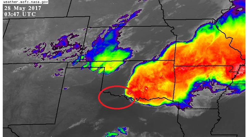
NAM has some semblance of a line mostly from Dallas east(DFW might miss out on that solution)
Texas Spring 2017
Moderator: S2k Moderators
Forum rules

The posts in this forum are NOT official forecast and should not be used as such. They are just the opinion of the poster and may or may not be backed by sound meteorological data. They are NOT endorsed by any professional institution or STORM2K.
-
Brent
- S2K Supporter

- Posts: 38753
- Age: 37
- Joined: Sun May 16, 2004 10:30 pm
- Location: Tulsa Oklahoma
- Contact:
Re: Texas Spring 2017
HRRR almost completely dissipates the Oklahoma stuff before ever reaching DFW 
NAM has some semblance of a line mostly from Dallas east(DFW might miss out on that solution)
NAM has some semblance of a line mostly from Dallas east(DFW might miss out on that solution)
Last edited by Brent on Sat May 27, 2017 10:59 pm, edited 1 time in total.
0 likes
#neversummer
-
bubba hotep

- S2K Supporter
- Posts: 6014
- Joined: Wed Dec 28, 2016 1:00 am
- Location: Collin County Texas
Re: Texas Spring 2017
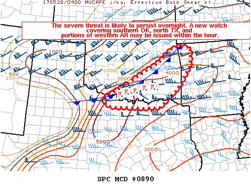
Storms in southern Oklahoma have started to back build and are taking on more of a southerly push. Watching the circle for additional development.
0 likes
Winter time post are almost exclusively focused on the DFW area.
-
bubba hotep
- S2K Supporter
- Posts: 6014
- Joined: Wed Dec 28, 2016 1:00 am
- Location: Collin County Texas
Re: Texas Spring 2017
Brent wrote:HRRR almost completely dissipates the Oklahoma stuff before ever reaching DFW
Saw that, I'm all in on the 00z 3k NAM lol
0 likes
Winter time post are almost exclusively focused on the DFW area.
-
bubba hotep
- S2K Supporter
- Posts: 6014
- Joined: Wed Dec 28, 2016 1:00 am
- Location: Collin County Texas
Re: Texas Spring 2017
Looks to be some decent lift associated with the front as storms are slowly firing SW along the front
https://twitter.com/whatisthisrds/status/868681855712845824
https://twitter.com/whatisthisrds/status/868681855712845824
0 likes
Winter time post are almost exclusively focused on the DFW area.
-
bubba hotep
- S2K Supporter
- Posts: 6014
- Joined: Wed Dec 28, 2016 1:00 am
- Location: Collin County Texas
Re: Texas Spring 2017
Watch possibly coming for the northern portions of DFW
0 likes
Winter time post are almost exclusively focused on the DFW area.
-
Brent
- S2K Supporter
- Posts: 38753
- Age: 37
- Joined: Sun May 16, 2004 10:30 pm
- Location: Tulsa Oklahoma
- Contact:
Re: Texas Spring 2017
 The line actually looks promising atm
The HRRR slides it north of even the northern DFW metro though as it dies
ETA: The Euro still looks promising to open June, DFW gets almost 3 inches of rain by June 2nd, as of this post, DFW has less than an inch this month.
0 likes
#neversummer
Re: Texas Spring 2017
Quite the lightning show creeping towards DFW. Looks like the cluster out of Oklahoma is going to make it for a large portion of the area. Bueno.
Denton and Collin counties should be getting in on the action soon.
Denton and Collin counties should be getting in on the action soon.
0 likes
Re: Texas Spring 2017
As usual, a very breif shower near the big airport. Just enough to get everything wet and leave a million dirt spots on my car. On to the next chance.
0 likes


Re: Texas Spring 2017
DFW airport picked up 0.01" of rain. On the bright side winds have switched NE so not as hot or feel as terrible today.
Southern half of the state could be wet this week with an active pattern
Southern half of the state could be wet this week with an active pattern
0 likes
The above post and any post by Ntxw is NOT an official forecast and should not be used as such. It is just the opinion of the poster and may or may not be backed by sound meteorological data. It is NOT endorsed by any professional institution including Storm2k. For official information, please refer to NWS products.
Help support Storm2K!
-
bubba hotep
- S2K Supporter
- Posts: 6014
- Joined: Wed Dec 28, 2016 1:00 am
- Location: Collin County Texas
Re: Texas Spring 2017
Brent wrote:
ETA: The Euro still looks promising to open June, DFW gets almost 3 inches of rain by June 2nd, as of this post, DFW has less than an inch this month.
Regardless of what the Euro shows, shift this south a bit and it is probably right. DFW rain hole!

0 likes
Winter time post are almost exclusively focused on the DFW area.
Re: Texas Spring 2017
Some light spotty rain along a front and/or boundary cutting the middle of the metroplex
0 likes
The above post and any post by Ntxw is NOT an official forecast and should not be used as such. It is just the opinion of the poster and may or may not be backed by sound meteorological data. It is NOT endorsed by any professional institution including Storm2k. For official information, please refer to NWS products.
Help support Storm2K!
Help support Storm2K!
-
gboudx

- S2K Supporter
- Posts: 4090
- Joined: Thu Sep 04, 2003 1:39 pm
- Location: Rockwall, Tx but from Harvey, La
Re: Texas Spring 2017
The boundary is stationary. I'm guessing an outflow that has stalled. I wonder if it could be the focus for convection later today?
0 likes
Re: Texas Spring 2017
gboudx wrote:The boundary is stationary. I'm guessing an outflow that has stalled. I wonder if it could be the focus for convection later today?
If convection where to go today, along and south of this boundary likely has the best chance assuming there is some lift
0 likes
The above post and any post by Ntxw is NOT an official forecast and should not be used as such. It is just the opinion of the poster and may or may not be backed by sound meteorological data. It is NOT endorsed by any professional institution including Storm2k. For official information, please refer to NWS products.
Help support Storm2K!
Help support Storm2K!


Re: Texas Spring 2017
bubba hotep wrote:Brent wrote:
ETA: The Euro still looks promising to open June, DFW gets almost 3 inches of rain by June 2nd, as of this post, DFW has less than an inch this month.
Regardless of what the Euro shows, shift this south a bit and it is probably right. DFW rain hole!
http://www.tropicaltidbits.com/analysis ... cus_28.png
Rainfall forecast models get the forecasted amount right, but get area forecasted wrong.
0 likes
Re: Texas Spring 2017
74 and drizzle today. Far cry from the 90s at this time past couple days and relief.
0 likes
The above post and any post by Ntxw is NOT an official forecast and should not be used as such. It is just the opinion of the poster and may or may not be backed by sound meteorological data. It is NOT endorsed by any professional institution including Storm2k. For official information, please refer to NWS products.
Help support Storm2K!
Help support Storm2K!
Re: Texas Spring 2017
There is also a lot of popcorn showers between DFW and Abilene, doesn't seem like we will warm up much more today. That frontal boundary is definitely keeping things a little active
0 likes
The above post and any post by Ntxw is NOT an official forecast and should not be used as such. It is just the opinion of the poster and may or may not be backed by sound meteorological data. It is NOT endorsed by any professional institution including Storm2k. For official information, please refer to NWS products.
Help support Storm2K!
Help support Storm2K!
-
bubba hotep
- S2K Supporter
- Posts: 6014
- Joined: Wed Dec 28, 2016 1:00 am
- Location: Collin County Texas
Re: Texas Spring 2017
Ntxw wrote:There is also a lot of popcorn showers between DFW and Abilene, doesn't seem like we will warm up much more today. That frontal boundary is definitely keeping things a little active
The front is being very stubborn and not making much progress, that should allow for elevated showers and storms to hang around the DFW are a little longer than expected. Now, maybe the front never moves as far south as modeled?
1 likes
Winter time post are almost exclusively focused on the DFW area.
-
bubba hotep
- S2K Supporter
- Posts: 6014
- Joined: Wed Dec 28, 2016 1:00 am
- Location: Collin County Texas
Re: Texas Spring 2017
Getting a lot of thunder out this way!
0 likes
Winter time post are almost exclusively focused on the DFW area.
-
Brent
- S2K Supporter
- Posts: 38753
- Age: 37
- Joined: Sun May 16, 2004 10:30 pm
- Location: Tulsa Oklahoma
- Contact:
Re: Texas Spring 2017
Surprised to hear thunder is the front stalling further north than forecast?
0 likes
#neversummer
Re: Texas Spring 2017
Brent wrote:Surprised to hear thunder is the front stalling further north than forecast?
Wpc surface analysis shows a warm front in N Tex vs cold front elsewhere. Elevated showers extend all the way back to KMAF (midland) and when they hit I-35 and east they become better organized near the boundary
0 likes
The above post and any post by Ntxw is NOT an official forecast and should not be used as such. It is just the opinion of the poster and may or may not be backed by sound meteorological data. It is NOT endorsed by any professional institution including Storm2k. For official information, please refer to NWS products.
Help support Storm2K!
Help support Storm2K!