Texas Spring 2017

U.S. & Caribbean Weather Discussions and Severe Weather Events

Moderator: S2k Moderators

Forum rules

The posts in this forum are NOT official forecast and should not be used as such. They are just the opinion of the poster and may or may not be backed by sound meteorological data. They are NOT endorsed by any professional institution or STORM2K.

Help Support Storm2K
Message
Author
Ralph's Weather
S2K Supporter
S2K Supporter
Posts: 3269
Age: 38
Joined: Fri Dec 13, 2013 11:55 am
Location: Lindale, TX
Contact:

Re: Texas Spring 2017

#1121 Postby Ralph's Weather » Fri May 19, 2017 9:09 am

Ntxw wrote:Today is more confidence in QPF, question remains how much. There should at the very least be a squall line late this evening, though on and off activity before that will be likely. Yesterday, as bad as it was, was never really forecast to be a high precipitation day since cap was in place it was a question of if storms got going far enough south for severe weather and did but too far west.

By Mon-Weds it will be unseasonably cool. Indeed Brent mentioned above the 73/55 GFS forecast for next Weds is close to the 72/54 lowest daily max and daily low for the date


72/47 are the records for Tyler on the 24th. The 72 is very much in danger and 60s possible if clouds hold on if they clear out early then the 47 is in danger.
0 likes   
Follow on Facebook at Ralph's Weather.

User avatar
Ntxw
Storm2k Moderator
Storm2k Moderator
Posts: 22785
Joined: Wed Oct 21, 2009 6:34 pm
Location: DFW, Texas

Re: Texas Spring 2017

#1122 Postby Ntxw » Fri May 19, 2017 9:13 am

bubba hotep wrote:The Euro Weeklies now go out to the July 4th holiday and show no signs of big heat. In fact, things look mostly below normal. There is a chance that May could be the 1st below normal month in over two years!


This week will make a big dent the final week for the monthly departure, you're right it has been a long time. I will be keeping an eye on precipitation forecasts for July. When it's wet the odds of heat is really cut down. Especially if you get them during the apex July and August heat.
0 likes   
The above post and any post by Ntxw is NOT an official forecast and should not be used as such. It is just the opinion of the poster and may or may not be backed by sound meteorological data. It is NOT endorsed by any professional institution including Storm2k. For official information, please refer to NWS products.

  Help support Storm2K!
Help Support Storm2K

User avatar
Ntxw
Storm2k Moderator
Storm2k Moderator
Posts: 22785
Joined: Wed Oct 21, 2009 6:34 pm
Location: DFW, Texas

Re: Texas Spring 2017

#1123 Postby Ntxw » Fri May 19, 2017 9:17 am

Image
0 likes   
The above post and any post by Ntxw is NOT an official forecast and should not be used as such. It is just the opinion of the poster and may or may not be backed by sound meteorological data. It is NOT endorsed by any professional institution including Storm2k. For official information, please refer to NWS products.


  Help support Storm2K!

Help Support Storm2K


weatherdude1108
Category 5
Category 5
Posts: 4228
Joined: Tue Dec 13, 2011 1:04 pm
Location: Northwest Austin/Cedar Park, TX

Re: Texas Spring 2017

#1124 Postby weatherdude1108 » Fri May 19, 2017 9:20 am

Ntxw wrote:Image


Could you move that more south, please? :P
0 likes   
The preceding post is NOT an official forecast, and should not be used as such. It is only the opinion of the poster and may or may not be backed by sound meteorological data. It is NOT endorsed by any professional institution including storm2k.org. For Official Information please refer to the NHC and NWS products.

User avatar
bubba hotep
S2K Supporter
S2K Supporter
Posts: 5837
Joined: Wed Dec 28, 2016 1:00 am
Location: Collin County Texas

Re: Texas Spring 2017

#1125 Postby bubba hotep » Fri May 19, 2017 10:01 am

HRRR would be interesting with a batch of storms this evening and the a squall line pushing through overnight.
Image
0 likes   
Winter time post are almost exclusively focused on the DFW area.

User avatar
Ntxw
Storm2k Moderator
Storm2k Moderator
Posts: 22785
Joined: Wed Oct 21, 2009 6:34 pm
Location: DFW, Texas

Re: Texas Spring 2017

#1126 Postby Ntxw » Fri May 19, 2017 10:16 am

There is a weak line of showers/boundary that is slowly moving through. I wonder if this will be focus for some storms or training later in the day? It doesn't seem to be moving very fast.

Image
0 likes   
The above post and any post by Ntxw is NOT an official forecast and should not be used as such. It is just the opinion of the poster and may or may not be backed by sound meteorological data. It is NOT endorsed by any professional institution including Storm2k. For official information, please refer to NWS products.


  Help support Storm2K!

Help Support Storm2K


User avatar
bubba hotep
S2K Supporter
S2K Supporter
Posts: 5837
Joined: Wed Dec 28, 2016 1:00 am
Location: Collin County Texas

Re: Texas Spring 2017

#1127 Postby bubba hotep » Fri May 19, 2017 10:34 am

Ntxw wrote:There is a weak line of showers/boundary that is slowly moving through. I wonder if this will be focus for some storms or training later in the day? It doesn't seem to be moving very fast.

Image


I was thinking the same. It looks the associated forcing is lifting NE into OK. That could leave the associated boundary draped across the DFW area.

Image
0 likes   
Winter time post are almost exclusively focused on the DFW area.

User avatar
bubba hotep
S2K Supporter
S2K Supporter
Posts: 5837
Joined: Wed Dec 28, 2016 1:00 am
Location: Collin County Texas

Re: Texas Spring 2017

#1128 Postby bubba hotep » Fri May 19, 2017 11:36 am

Latest SPC update maintains ENH for DFW with 5% Tor but 30% wind & hail.
0 likes   
Winter time post are almost exclusively focused on the DFW area.

User avatar
bubba hotep
S2K Supporter
S2K Supporter
Posts: 5837
Joined: Wed Dec 28, 2016 1:00 am
Location: Collin County Texas

Re: Texas Spring 2017

#1129 Postby bubba hotep » Fri May 19, 2017 12:42 pm

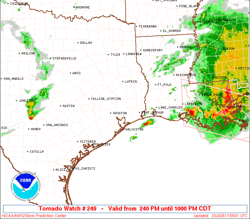
1st watch of the day
Image
0 likes   
Winter time post are almost exclusively focused on the DFW area.

User avatar
Ntxw
Storm2k Moderator
Storm2k Moderator
Posts: 22785
Joined: Wed Oct 21, 2009 6:34 pm
Location: DFW, Texas

Re: Texas Spring 2017

#1130 Postby Ntxw » Fri May 19, 2017 1:22 pm

Tor warned storm moving towards Abilene

Tornado Warning
TXC253-441-191845-
/O.NEW.KSJT.TO.W.0023.170519T1817Z-170519T1845Z/

BULLETIN - EAS ACTIVATION REQUESTED
Tornado Warning
National Weather Service San Angelo TX
117 PM CDT FRI MAY 19 2017

The National Weather Service in San Angelo has issued a

* Tornado Warning for...
Southeastern Jones County in west central Texas...
Northeastern Taylor County in west central Texas...

* Until 145 PM CDT

* At 116 PM CDT, a confirmed tornado was located south of Dyess Air
Force base , or 9 miles southwest of Abilene, moving northeast at
35 mph.

HAZARD...Damaging tornado and quarter size hail.

SOURCE...Public confirmed tornado.

IMPACT...Flying debris will be dangerous to those caught without
shelter. Mobile homes will be damaged or destroyed.
Damage to roofs, windows, and vehicles will occur. Tree
damage is likely.

Image
0 likes   
The above post and any post by Ntxw is NOT an official forecast and should not be used as such. It is just the opinion of the poster and may or may not be backed by sound meteorological data. It is NOT endorsed by any professional institution including Storm2k. For official information, please refer to NWS products.


  Help support Storm2K!

Help Support Storm2K


weatherdude1108
Category 5
Category 5
Posts: 4228
Joined: Tue Dec 13, 2011 1:04 pm
Location: Northwest Austin/Cedar Park, TX

Re: Texas Spring 2017

#1131 Postby weatherdude1108 » Fri May 19, 2017 3:17 pm

Good discussion this afternoon from the EWX office about the infamous CAP. :roll:


000
FXUS64 KEWX 191951
AFDEWX

Area Forecast Discussion
National Weather Service Austin/San Antonio TX
251 PM CDT Fri May 19 2017

.SHORT TERM (Tonight through Saturday Night)...
A complicated forecast continues for South-Central Texas as the daily
battle with the CAP enters its fourth day of competition. The CAP has
easily won out as there has been little to no weakening of the CAP
without the presence of large scale forcing or any surface boundary
to help drive parcels up and through the CAP to break it. Latest
aircraft soundings for KSAT/KAUS continue to show nearly 150 J/kg of
inhibition for surface based parcels as of 19z. This amount of CIN
is much too high for only surface heating parcels to break through
and we would need some other forcing mechanism to lift/weaken the CAP
for convection to develop.
Normally to weaken or lift a CAP you
would need forcing for ascent as consistent lifting of the level of
the inversion would lead to adiabatic cooling of the CAP and thus
weakening. We have not had this as the upper low remains well to our
northwest and we are not experiencing any of the effects of the
strong lift. In addition, approaching upper lows also lead to the
cooling of the atmosphere within these cold core centers, and again
we are not seeing this as well. Without either of these occurring,
the CAP will continue to win out until something change, but more on
that later.

The 12z KDRT observed sounding had a convective temperature
(temperature the surface needs to warm to for free convection) of 95
degrees. With forecast highs only near 90, am also not expecting this
to happen.
Starting to see some thunderstorm activity west of the
Rio Grande but slow storm motions and effects of the CAP should not
allow this activity to make it east of the Rio Grande, but will
continue to monitor. With the probabilities of developing storms in
our area low, we will have to turn to potential activity from the
northwest eventually moving into the CWA. Convection to our north
has remained cellular with storms moving to the northeast away from
the area. Will have to watch for new development eventually
congealing into a line to our north and this could eventually move
into our northern CWA and Hill Country counties this evening and
overnight. Some of this activity could be strong to severe if it
makes it this way and SPC maintains a marginal to slight risk for
this area.

Further to the north a cold front is moving through the Texas
Panhandle and with adequate effects from forcing in relation to the
ejecting upper low near Colorado, this front should begin to arrive
to our northern counties late tonight and tomorrow morning. This
front should finally serve as the impetus to allow for the
development of showers and storms as it slowly moves through the
region tomorrow. Fronts serve as a source of mesoscale lift and this
should finally force parcels to the LFC. Think the CAP should help
limit the overall coverage,
but we should see scattered activity by
the afternoon hours. The local storm environment will have CAPE
values near 3,000 J/kg with weak to moderate shear values. This
should support the threat of some possible marginally severe hail and
perhaps gusty winds. Most of the area is now under a slight risk of
severe storms for this threat. PW values near 1.75 inches could also
lead to locally heavy rainfall. There are some hints of the coverage
of showers and storms slightly increasing after sunset tomorrow for a
few hours as the low- level jet enhances the lift in the lower
levels of the atmosphere.


&&

.LONG TERM (Sunday through Friday)...
Should continue to see the chance of showers and thunderstorms on
Sunday with north winds remaining in place behind the frontal
boundary, but overall chances should be lower than Saturday and
Saturday night. Rain chances will increase again Sunday night and
Monday as a shortwave embedded within a split flow regime moves
through the region. The upper level lift will become enhanced as it
lifts air above the lingering frontal layer with continued north
winds at the surface. Increased the PoPs to 40-60 percent but these
may need to be increased over the next couple of forecast cycles.
With these split flow regimes, upper flow in the southern branch of
the jet is usually weaker than the main jet which could lead to
weaker storm motions and enhanced rainfall amounts.
However,
deterministic model solutions continue to show rainfall amounts not
reaching that high
.

Our last hoorah will be Tuesday as an impulse rotating around a deep
upper low near the Ohio Valley will force a cold front south into
Texas. Should see shower and thunderstorm activity ahead of the front
as it moves through by Tuesday afternoon. Will linger PoPs into
Tuesday night as there are some discrepancies with the timing between
the GFS and ECMWF. Overall, rainfall amounts between now and Tuesday
will be around 1-3 inches with isolated amounts up to 5 inches.

Temperatures behind the front will be in the 50s/60s Wednesday and
Thursday morning with highs in the 70s
and lower 80s.
0 likes   
The preceding post is NOT an official forecast, and should not be used as such. It is only the opinion of the poster and may or may not be backed by sound meteorological data. It is NOT endorsed by any professional institution including storm2k.org. For Official Information please refer to the NHC and NWS products.

User avatar
bubba hotep
S2K Supporter
S2K Supporter
Posts: 5837
Joined: Wed Dec 28, 2016 1:00 am
Location: Collin County Texas

Re: Texas Spring 2017

#1132 Postby bubba hotep » Fri May 19, 2017 3:29 pm

18z special from FWD shows the cap almost gone.
0 likes   
Winter time post are almost exclusively focused on the DFW area.

User avatar
bubba hotep
S2K Supporter
S2K Supporter
Posts: 5837
Joined: Wed Dec 28, 2016 1:00 am
Location: Collin County Texas

Re: Texas Spring 2017

#1133 Postby bubba hotep » Fri May 19, 2017 3:31 pm

Image
0 likes   
Winter time post are almost exclusively focused on the DFW area.

Yukon Cornelius
S2K Supporter
S2K Supporter
Posts: 1798
Age: 41
Joined: Thu Dec 20, 2012 9:23 pm
Location: Dean, TX/Westcliffe, CO

Re: Texas Spring 2017

#1134 Postby Yukon Cornelius » Fri May 19, 2017 3:56 pm

Only made it to 66 here today, but with really high humidity. We have been getting hammered all day by thunderstorms, which has definitely been needed with as dry as everything has been and starting to slip into drought conditions.
0 likes   
#neversummer

User avatar
Ntxw
Storm2k Moderator
Storm2k Moderator
Posts: 22785
Joined: Wed Oct 21, 2009 6:34 pm
Location: DFW, Texas

Re: Texas Spring 2017

#1135 Postby Ntxw » Fri May 19, 2017 4:09 pm

Yukon Cornelius wrote:Only made it to 66 here today, but with really high humidity. We have been getting hammered all day by thunderstorms, which has definitely been needed with as dry as everything has been and starting to slip into drought conditions.


Radar shows 2-4" around the falls and slightly heavier to the west NW.

Starting to see popcorn showers eastplexers
0 likes   
The above post and any post by Ntxw is NOT an official forecast and should not be used as such. It is just the opinion of the poster and may or may not be backed by sound meteorological data. It is NOT endorsed by any professional institution including Storm2k. For official information, please refer to NWS products.


  Help support Storm2K!

Help Support Storm2K


User avatar
bubba hotep
S2K Supporter
S2K Supporter
Posts: 5837
Joined: Wed Dec 28, 2016 1:00 am
Location: Collin County Texas

Re: Texas Spring 2017

#1136 Postby bubba hotep » Fri May 19, 2017 4:28 pm

Sat and radar are showing a much more agitated warm sector across portions of Texas than we saw yesterday. Wonder if any of those showers will be able to maintain updrafts and get rooted. Maybe some discrete cells in the open warm sector later?
0 likes   
Winter time post are almost exclusively focused on the DFW area.

Yukon Cornelius
S2K Supporter
S2K Supporter
Posts: 1798
Age: 41
Joined: Thu Dec 20, 2012 9:23 pm
Location: Dean, TX/Westcliffe, CO

Re: Texas Spring 2017

#1137 Postby Yukon Cornelius » Fri May 19, 2017 5:51 pm

Ntxw wrote:
Yukon Cornelius wrote:Only made it to 66 here today, but with really high humidity. We have been getting hammered all day by thunderstorms, which has definitely been needed with as dry as everything has been and starting to slip into drought conditions.


Radar shows 2-4" around the falls and slightly heavier to the west NW.

Starting to see popcorn showers eastplexers

I'm in Clay County now, a little bit NE of WF and so far today I've measured 1.5" with what looks like more to come. WF has definitely gotten a little bit more. Last night's storms measured right at 1" so in the last 24 hours we are doing good rain wise. I couldn't be anymore thankful for it.
2 likes   
#neversummer

User avatar
bubba hotep
S2K Supporter
S2K Supporter
Posts: 5837
Joined: Wed Dec 28, 2016 1:00 am
Location: Collin County Texas

Re: Texas Spring 2017

#1138 Postby bubba hotep » Fri May 19, 2017 6:18 pm

Storms are on the increase to the SW of DFW and surface winds are kicking here in downtown.
0 likes   
Winter time post are almost exclusively focused on the DFW area.

Brent
S2K Supporter
S2K Supporter
Posts: 38090
Age: 36
Joined: Sun May 16, 2004 10:30 pm
Location: Tulsa Oklahoma
Contact:

Re: Texas Spring 2017

#1139 Postby Brent » Fri May 19, 2017 7:10 pm

This is taking forever to get going around DFW. Models had a line in the metro by now...
0 likes   
#neversummer

User avatar
Ntxw
Storm2k Moderator
Storm2k Moderator
Posts: 22785
Joined: Wed Oct 21, 2009 6:34 pm
Location: DFW, Texas

Re: Texas Spring 2017

#1140 Postby Ntxw » Fri May 19, 2017 7:12 pm

Brent wrote:This is taking forever to get going around DFW. Models had a line in the metro by now...


Forever is right, slugging all day
0 likes   
The above post and any post by Ntxw is NOT an official forecast and should not be used as such. It is just the opinion of the poster and may or may not be backed by sound meteorological data. It is NOT endorsed by any professional institution including Storm2k. For official information, please refer to NWS products.


  Help support Storm2K!

Help Support Storm2K


Return to “USA & Caribbean Weather”

Who is online

Users browsing this forum: Brent and 12 guests