Texas Spring 2017
Moderator: S2k Moderators
Forum rules

The posts in this forum are NOT official forecast and should not be used as such. They are just the opinion of the poster and may or may not be backed by sound meteorological data. They are NOT endorsed by any professional institution or STORM2K.

Re: Texas Spring 2017
I'd like to hear everyone's opinion on this season's persistent strong cap, given that it plays a big role in whether we get storms or not.
0 likes
Resident Rain Miser
I am a weather hobbyist living 3.5 miles south of Downtown Austin and in no way or fashion should anything I say concerning forecasts be taken seriously. Please check your local NWS for accurate weather forecasting and conditions.
I am a weather hobbyist living 3.5 miles south of Downtown Austin and in no way or fashion should anything I say concerning forecasts be taken seriously. Please check your local NWS for accurate weather forecasting and conditions.
-
weatherdude1108
- Category 5

- Posts: 4228
- Joined: Tue Dec 13, 2011 1:04 pm
- Location: Northwest Austin/Cedar Park, TX
Re: Texas Spring 2017
Regarding the cap, I think it tends to be stronger down here most of the time due to our proximity to Mexico. The mid-level flow from the southwest most times contains relatively warm, dry air from the plateaus of Mexico (except during El Niños). As these winds descend off the plateaus of Mexico in our direction and if they reach the surface, they dry further through compressional warming, which squashes any convective initiation in the cloud tops that get going. Seems like the winds in the upper levels have not been in our favor for good rains over the past month and a half. I don't know exactly why (?).
0 likes
The preceding post is NOT an official forecast, and should not be used as such. It is only the opinion of the poster and may or may not be backed by sound meteorological data. It is NOT endorsed by any professional institution including storm2k.org. For Official Information please refer to the NHC and NWS products.


Re: Texas Spring 2017
weatherdude1108 wrote:Regarding the cap, I think it tends to be stronger down here most of the time due to our proximity to Mexico. The mid-level flow from the southwest most times contains relatively warm, dry air from the plateaus of Mexico (except during El Niños). As these winds descend off the plateaus of Mexico in our direction and if they reach the surface, they dry further through compressional warming, which squashes any convective initiation in the cloud tops that get going. Seems like the winds in the upper levels have not been in our favor for good rains over the past month and a half. I don't know exactly why (?).
You are correct, instead of thinking it as the cap is stronger rather be in mindset the cap is a consistent existence. Some years we erode it easier with stronger shortwaves moving further south, or a strong subtropical jet to overwhelm it. As weatherdude mentioned most often the two coincides with El Nino type patterns. So far this spring much of the energy has been too far north or cuts up west, with little or no STJ help
2 likes
The above post and any post by Ntxw is NOT an official forecast and should not be used as such. It is just the opinion of the poster and may or may not be backed by sound meteorological data. It is NOT endorsed by any professional institution including Storm2k. For official information, please refer to NWS products.
Help support Storm2K!

Re: Texas Spring 2017
JDawg512 wrote:I'd like to hear everyone's opinion on this season's persistent strong cap, given that it plays a big role in whether we get storms or not.
The cap is your best friend or worst enemy. If you love severe weather, you really need the cap. If you would just like regular rainfall without severe weather, the cap is your enemy.
I'm hoping that this is not a precursor to another 2011 type Summer.
0 likes
The above post and any post by dhweather is NOT an official forecast and should not be used as such. It is just the opinion of the poster and may or may not be backed by sound meteorological data. It is NOT endorsed by any professional institution including storm2k.org. For official information, please refer to NWS products.
-
TheProfessor

- Professional-Met

- Posts: 3506
- Age: 29
- Joined: Tue Dec 03, 2013 10:56 am
- Location: Wichita, Kansas
Re: Texas Spring 2017
dhweather wrote:JDawg512 wrote:I'd like to hear everyone's opinion on this season's persistent strong cap, given that it plays a big role in whether we get storms or not.
The cap is your best friend or worst enemy. If you love severe weather, you really need the cap. If you would just like regular rainfall without severe weather, the cap is your enemy.
I'm hoping that this is not a precursor to another 2011 type Summer.
I wouldn't say you necessarily say you need the Cap, especially further east during outbreaks where it's more about timing, mode, movement and placement. Yes a strong cap can help raise parameters, but it also needs strong forcing to be broken through. This can cause a delay in storms, preventing Supercells from forming and the mode being more linear along a frontal system instead. A weak capping inversion is typically best. Although it might not have an influence on parameters, but in strong storm systems with ample moisture there doesn't need to be. The weaker capping allows for storms to form on other weaker boundaries like outflow boundaries, which can also enhance storms.
0 likes
An alumnus of The Ohio State University.
Your local National Weather Service office is your best source for weather information.
Your local National Weather Service office is your best source for weather information.
-
TheProfessor
- Professional-Met
- Posts: 3506
- Age: 29
- Joined: Tue Dec 03, 2013 10:56 am
- Location: Wichita, Kansas
Re: Texas Spring 2017
The Skew-T for Thursday Evening in North Texas on the 12z GFS would be an epic one if the winds were better.
0 likes
An alumnus of The Ohio State University.
Your local National Weather Service office is your best source for weather information.
Your local National Weather Service office is your best source for weather information.

Re: Texas Spring 2017
I would like to know what the CPC is seeing in regards to rain for SE TX because the GFS is saying hardly any rain at all over here.
0 likes
-
South Texas Storms

- Professional-Met
- Posts: 4259
- Joined: Thu Jun 24, 2010 12:28 am
- Location: Houston, TX
Re: Texas Spring 2017
Cpv17 wrote:I would like to know what the CPC is seeing in regards to rain for SE TX because the GFS is saying hardly any rain at all over here.
CPC must be going with the Euro and Canadian because those models are much wetter across SE TX than the GFS.
0 likes
-
bubba hotep

- S2K Supporter

- Posts: 6014
- Joined: Wed Dec 28, 2016 1:00 am
- Location: Collin County Texas
Re: Texas Spring 2017
TheProfessor wrote:The Skew-T for Thursday Evening in North Texas on the 12z GFS would be an epic one if the winds were better.
Thursday does look like a day to keep an eye on, maybe the day with the highest potential risk for N. Texas over the next week but the threat does linger into the weekend:
0 likes
Winter time post are almost exclusively focused on the DFW area.
-
bubba hotep
- S2K Supporter
- Posts: 6014
- Joined: Wed Dec 28, 2016 1:00 am
- Location: Collin County Texas
Re: Texas Spring 2017
South Texas Storms wrote:Cpv17 wrote:I would like to know what the CPC is seeing in regards to rain for SE TX because the GFS is saying hardly any rain at all over here.
CPC must be going with the Euro and Canadian because those models are much wetter across SE TX than the GFS.
WPC has also shifted the heavier totals southward, more in line with the EURO.
2 likes
Winter time post are almost exclusively focused on the DFW area.
-
bubba hotep
- S2K Supporter
- Posts: 6014
- Joined: Wed Dec 28, 2016 1:00 am
- Location: Collin County Texas
Re: Texas Spring 2017
Looking more and more like Thursday could be a big day across the Southern Plains. The Euro EPS has a mean CAPE of 2,400 at DFW for 00z, that is pretty big for the mean at that range. The EPS 500mb mean at 12z on Thursday from the 12z run today:

1 likes
Winter time post are almost exclusively focused on the DFW area.
-
TheProfessor
- Professional-Met
- Posts: 3506
- Age: 29
- Joined: Tue Dec 03, 2013 10:56 am
- Location: Wichita, Kansas
Re: Texas Spring 2017
bubba hotep wrote:Looking more and more like Thursday could be a big day across the Southern Plains. The Euro EPS has a mean CAPE of 2,400 at DFW for 00z, that is pretty big for the mean at that range. The EPS 500mb mean at 12z on Thursday from the 12z run today:
http://www.tropicaltidbits.com/analysis ... amer_5.png
I'd like to see that trough a bit more negative tilted, It would allow for better Severe weather potential as well as rain potential.
2 likes
An alumnus of The Ohio State University.
Your local National Weather Service office is your best source for weather information.
Your local National Weather Service office is your best source for weather information.
-
TeamPlayersBlue

- Category 5
- Posts: 3531
- Joined: Tue Feb 02, 2010 1:44 am
- Location: Denver/Applewood, CO
Re: Texas Spring 2017
bubba hotep wrote:Ntxw wrote:A little off topic but not to be forgotten. The Solar Minimum is approaching."SUNSPOT COUNTS ARE PLUMMETING: Today marks the 33rd day in 2017 that the sun has been blank--no sunspots. This exceeds the total number of spotless days in all of 2016 (32). The accelerating pace of spotlessness is a sign that Solar Minimum is approaching. Forecasters expect the sunspot cycle, which swings like a pendulum between high and low sunspot number every ~11 years, to reach its nadir in 2019-2020. Stay tuned for more blank suns. "
http://spaceweather.com/
The last Solar Minimum bottomed out during 2009-2010 period :D
QBO also reversed during the summer of '09. Just saying
I like it. Is there any kind of "lag" that we should expect from sunspots? Almost like the super nino effects we have seen? (if the super nino effected things for a long time.)
Lack of sunspots was a big deal in back with the little ice age or the Maunder minimum.
0 likes
Personal Forecast Disclaimer:
The posts in this forum are NOT official forecast and should not be used as such. They are just the opinion of the poster and may or may not be backed by sound meteorological data. They are NOT endorsed by any professional institution or storm2k.org. For official information, please refer to the NHC and NWS products.
The posts in this forum are NOT official forecast and should not be used as such. They are just the opinion of the poster and may or may not be backed by sound meteorological data. They are NOT endorsed by any professional institution or storm2k.org. For official information, please refer to the NHC and NWS products.
Re: Texas Spring 2017
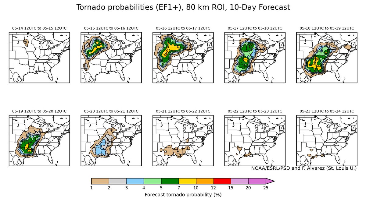
NWS Fort Worth might want to consider flash flood watches for central and northern parts of the forecast area Friday into Sat morning. Looks like a real May heavy rain event in store. Central and SE Tx timing is more Saturday.
2 likes
The above post and any post by Ntxw is NOT an official forecast and should not be used as such. It is just the opinion of the poster and may or may not be backed by sound meteorological data. It is NOT endorsed by any professional institution including Storm2k. For official information, please refer to NWS products.
Help support Storm2K!
Help support Storm2K!
-
srainhoutx

- S2K Supporter
- Posts: 6919
- Age: 68
- Joined: Sun Jan 14, 2007 11:34 am
- Location: Haywood County, NC
- Contact:
Re: Texas Spring 2017
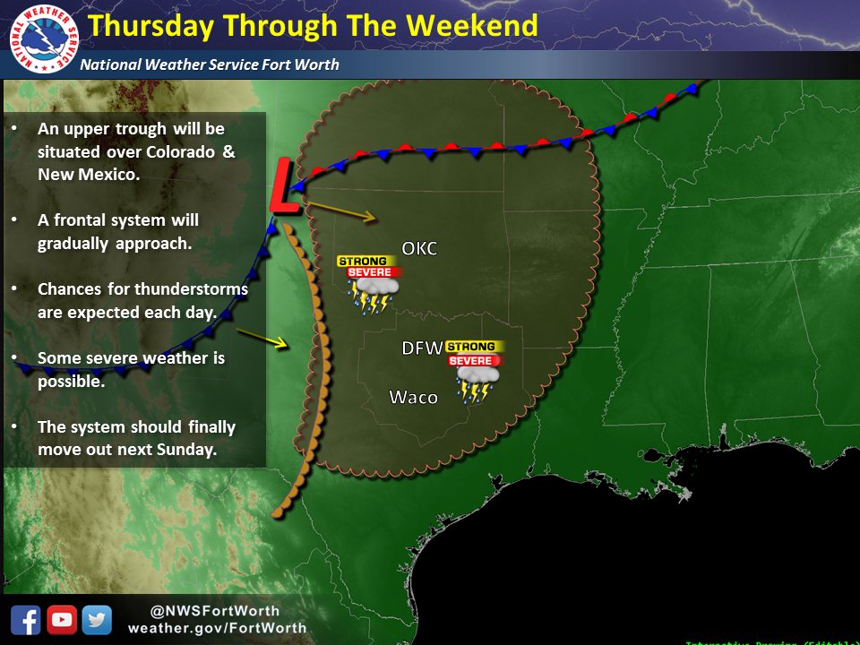
Monday morning briefing from Jeff:
After several weeks of generally nice weather…the upper air pattern will undergo changes that will allow a return of thunderstorms across the southern plains this week into next week.
Upper level blocking with high pressure over the southern plains the last week is shifting eastward allowing the semi-stationary upper level trough over the SW US to edge closer to the southern plains. The initial trough will eject into the plains on Wednesday, but a secondary trough will quickly dig back into the SW US late this week and very slowly move into the plains this weekend into early next week. Locally onshore winds have already returned to the region allowing a slow but steady increase in Gulf moisture. Air mass will slowly moisten over the next 48 hours before a surge of deeper moisture arrives on Wednesday. Will raise rain chances to 40% for Wednesday as this deeper moisture arrives and SE TX may get skirted by the tail end of lift from the ejecting SW US trough. Main dynamics with this system are aimed more toward the central plains. This week will provide near daily chances of severe weather including tornadoes across the plains.
Secondary trough digs into the SW US Thursday and Friday and this will position a SW flow aloft across the region. Weak disturbances in this flow aloft combined with the W TX dryline may result in complexes of thunderstorms developing to our west each afternoon and moving eastward during the overnight hours. Big questions at this time range are do any of these complexes make it as far east as SE TX or do their outflow arrive into the region during peak heating. Given a moist and generally unstable air mass in place from Wednesday onward will have to keep an eye on such potential.
Sub-tropical ridge aloft will shift a bit eastward this weekend and this will allow a very slow motion of the SW US trough eastward. A surface cold front will move into the state from the NW helping to act as a trigger for deep convection. Upper air parameters may become more favorable also for thunderstorm formation along with continued ejecting short wave disturbances out of the mean trough to our west. Timing of this all remains in question, but models are starting to key in on Saturday as the first day for potential widespread thunderstorms. Also starting to see a heavy rainfall signal in the models with QPF maxes of 3-5 inches over the weekend likely from some sort of slow moving thunderstorm complex (something to watch very closely).
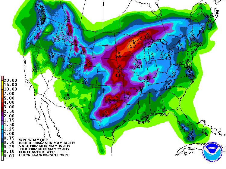
Very slow movement of the upper trough will continue to favor rounds of thunderstorms into early next week allowing rainfall totals to pile up. Each rough will likely pose some risk of severe weather given it is mid May and instability is generally decent this time of year. QPF amounts are highest across central TX into OK this week and enough rain may fall, even though grounds are generally dry, to activate run-off and rises on upstream rivers and creeks. Heavy rainfall signal drifts deeper into SE TX this weekend into early next week.
After several weeks of generally nice weather…the upper air pattern will undergo changes that will allow a return of thunderstorms across the southern plains this week into next week.
Upper level blocking with high pressure over the southern plains the last week is shifting eastward allowing the semi-stationary upper level trough over the SW US to edge closer to the southern plains. The initial trough will eject into the plains on Wednesday, but a secondary trough will quickly dig back into the SW US late this week and very slowly move into the plains this weekend into early next week. Locally onshore winds have already returned to the region allowing a slow but steady increase in Gulf moisture. Air mass will slowly moisten over the next 48 hours before a surge of deeper moisture arrives on Wednesday. Will raise rain chances to 40% for Wednesday as this deeper moisture arrives and SE TX may get skirted by the tail end of lift from the ejecting SW US trough. Main dynamics with this system are aimed more toward the central plains. This week will provide near daily chances of severe weather including tornadoes across the plains.
Secondary trough digs into the SW US Thursday and Friday and this will position a SW flow aloft across the region. Weak disturbances in this flow aloft combined with the W TX dryline may result in complexes of thunderstorms developing to our west each afternoon and moving eastward during the overnight hours. Big questions at this time range are do any of these complexes make it as far east as SE TX or do their outflow arrive into the region during peak heating. Given a moist and generally unstable air mass in place from Wednesday onward will have to keep an eye on such potential.
Sub-tropical ridge aloft will shift a bit eastward this weekend and this will allow a very slow motion of the SW US trough eastward. A surface cold front will move into the state from the NW helping to act as a trigger for deep convection. Upper air parameters may become more favorable also for thunderstorm formation along with continued ejecting short wave disturbances out of the mean trough to our west. Timing of this all remains in question, but models are starting to key in on Saturday as the first day for potential widespread thunderstorms. Also starting to see a heavy rainfall signal in the models with QPF maxes of 3-5 inches over the weekend likely from some sort of slow moving thunderstorm complex (something to watch very closely).
Very slow movement of the upper trough will continue to favor rounds of thunderstorms into early next week allowing rainfall totals to pile up. Each rough will likely pose some risk of severe weather given it is mid May and instability is generally decent this time of year. QPF amounts are highest across central TX into OK this week and enough rain may fall, even though grounds are generally dry, to activate run-off and rises on upstream rivers and creeks. Heavy rainfall signal drifts deeper into SE TX this weekend into early next week.
1 likes
Carla/Alicia/Jerry(In The Eye)/Michelle/Charley/Ivan/Dennis/Katrina/Rita/Wilma/Ike/Harvey
Member: National Weather Association
Wx Infinity Forums
http://wxinfinity.com/index.php
Facebook.com/WeatherInfinity
Twitter @WeatherInfinity
Member: National Weather Association
Wx Infinity Forums
http://wxinfinity.com/index.php
Facebook.com/WeatherInfinity
Twitter @WeatherInfinity
-
bubba hotep
- S2K Supporter
- Posts: 6014
- Joined: Wed Dec 28, 2016 1:00 am
- Location: Collin County Texas
Re: Texas Spring 2017
Ntxw wrote:NWS Fort Worth might want to consider flash flood watches for central and northern parts of the forecast area Friday into Sat morning. Looks like a real May heavy rain event in store. Central and SE Tx timing is more Saturday.
It will be interesting to see what they do. It looks like 6hr flash flood guidance for most of the DFW area is 5"+, so it would take an impressive individual setup or multiple rounds of heavy rain. The 12z GFS does show multiple rounds of storms with areas east of I35 picking up 4-5" over a couple of days.
0 likes
Winter time post are almost exclusively focused on the DFW area.
-
TheProfessor
- Professional-Met
- Posts: 3506
- Age: 29
- Joined: Tue Dec 03, 2013 10:56 am
- Location: Wichita, Kansas
Re: Texas Spring 2017
Looking at the Skew-ts for Friday on the 6z GFS and calculating a rough estimate for K-index it would seem on Friday the atmosphere would definitely support heavy rain with values between 30 and 40. However, KI has some flaws and isn't always the best to use, but in this case I think it's fine.
0 likes
An alumnus of The Ohio State University.
Your local National Weather Service office is your best source for weather information.
Your local National Weather Service office is your best source for weather information.
-
Yukon Cornelius
- S2K Supporter
- Posts: 1842
- Age: 42
- Joined: Thu Dec 20, 2012 9:23 pm
- Location: Dean, TX/Westcliffe, CO
Re: Texas Spring 2017
Too dang hot. 92 currently with a warm south wind. Hopefully this possible rain will help cool it off a little. Can we just skip summer and early fall?
0 likes
#neversummer
-
bubba hotep
- S2K Supporter
- Posts: 6014
- Joined: Wed Dec 28, 2016 1:00 am
- Location: Collin County Texas
Re: Texas Spring 2017
Don't look now, but the last couple of Euro runs have drastically cut back the rain for DFW. The 12z has less than an inch for most of the area and has the biggest totals out to the west. This is after showing a major rain event for days on end. It seems like anytime the Euro has shown snow or big rain for DFW in the 5 -10 period over the past year it has almost always been a swing an miss. Looks like it is happening again. Of course, the GFS has flipped and now has big totals for DFW, esp. east of I35 
1 likes
Winter time post are almost exclusively focused on the DFW area.
-
Brent
- S2K Supporter
- Posts: 38755
- Age: 37
- Joined: Sun May 16, 2004 10:30 pm
- Location: Tulsa Oklahoma
- Contact:
Re: Texas Spring 2017
bubba hotep wrote:Don't look now, but the last couple of Euro runs have drastically cut back the rain for DFW. The 12z has less than an inch for most of the area and has the biggest totals out to the west. This is after showing a major rain event for days on end. It seems like anytime the Euro has shown snow or big rain for DFW in the 5 -10 period over the past year it has almost always been a swing an miss. Looks like it is happening again. Of course, the GFS has flipped and now has big totals for DFW, esp. east of I35
These models I just can't sometimes... all that consistency then poof
0 likes
#neversummer
Return to “USA & Caribbean Weather”
Who is online
Users browsing this forum: A1A, AnnularCane and 129 guests