
Joe tends to exaggerate a lot. Just saying
[Disclaimer][/Disclaimer
Texas Winter 2016-2017
Moderator: S2k Moderators
Forum rules
 The posts in this forum are NOT official forecast and should not be used as such. They are just the opinion of the poster and may or may not be backed by sound meteorological data. They are NOT endorsed by any professional institution or STORM2K.

The posts in this forum are NOT official forecast and should not be used as such. They are just the opinion of the poster and may or may not be backed by sound meteorological data. They are NOT endorsed by any professional institution or STORM2K.
Re: Texas Winter 2016-2017
0 likes
-
srainhoutx

- S2K Supporter

- Posts: 6919
- Age: 68
- Joined: Sun Jan 14, 2007 11:34 am
- Location: Haywood County, NC
- Contact:
Re: Texas Winter 2016-2017
Friday morning briefing from Jeff:
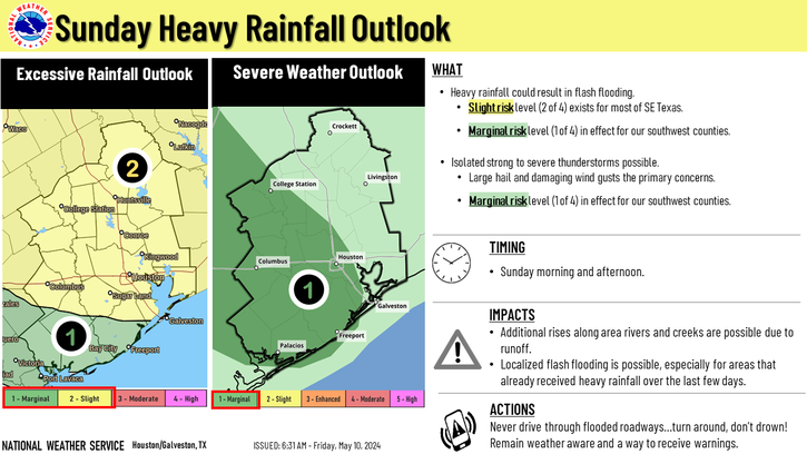
Heavy rainfall threat Sunday-Monday
Today:
Strong upper level system moving into SW TX spreading strong lift across a slowly moistening air mass. While surface layer is fairly dry inland, moisture has certainly increased near the coast allowing showers and thunderstorms to develop. Very cold mid level temperatures spreading into SW TX will overspread the coastal bend and SE TX coast this morning yielding good instability for thunderstorms to develop. Recent Corpus Christi radar shows the start of deep convection just north of Corpus Christi which will expand in coverage toward the ENE over the next several hours. Main threats will be brief heavy rainfall and possibly some small hail in the stronger storms.
Rainfall amounts will average 1-2 inches along the coast tapering to very little if any rainfall inland around College Station. Rainfall today will only help to wet and prime the grounds for the next storm system Sunday/Monday.
Sunday-Monday:
Next powerful storm system will move into CA today and then into Baja Saturday swinging eastward into SW TX Sunday and into E TX Monday. Ahead of this feature moisture will begin to greatly increase Saturday and Sunday with continued progged PWS values on Sunday rising to 1.5 inches and then upwards of 1.8 inches by Monday morning. Historic high PWS values for mid February for CRP are around 1.75 inches so by Monday morning we will be pushing near record moisture levels. The system continues to look highly convective and latest models have sped up the arrival of activity now into Sunday evening versus Monday morning. Arrival of strong upper air divergence a top a very moist air mass with potential for sustained cell training is pointing toward a flash flood threat Sunday night into Monday.
Expect strong to even severe thunderstorms to rapidly develop Sunday afternoon as mid level capping erodes across C TX roughly in the I-35 corridor from San Antonio to Austin. Storms will congeal into lines and clusters with both a severe and excessive rainfall threat and very slowly progress eastward into SE TX overnight Sunday. Speed of the overall system will help to determine how long rainfall continues on Monday, but big concern is moisture levels and potential for very high hourly rainfall rates of 2-3 inches.
Will go with widespread rainfall amounts of 2-3 inches with isolated totals up to 6 inches possible. This magnitude of rainfall on top of already moist grounds will result in significant run-off into area rivers, bayous, and creeks resulting is rises.
0 likes
Carla/Alicia/Jerry(In The Eye)/Michelle/Charley/Ivan/Dennis/Katrina/Rita/Wilma/Ike/Harvey
Member: National Weather Association
Wx Infinity Forums
http://wxinfinity.com/index.php
Facebook.com/WeatherInfinity
Twitter @WeatherInfinity
Member: National Weather Association
Wx Infinity Forums
http://wxinfinity.com/index.php
Facebook.com/WeatherInfinity
Twitter @WeatherInfinity
-
bubba hotep

- S2K Supporter
- Posts: 6014
- Joined: Wed Dec 28, 2016 1:00 am
- Location: Collin County Texas
Re: Texas Winter 2016-2017
Both the Euro EPS and GEFS are showing a "nina" like pattern returning by early March with the coldest NHEMI 850mb anomalies located over WCAN and down the Rockies into S. Plains.

2 likes
Winter time post are almost exclusively focused on the DFW area.

Re: Texas Winter 2016-2017
Nearly all members, initially, send the PNA negative as of this morning's forecast.
0 likes
The above post and any post by Ntxw is NOT an official forecast and should not be used as such. It is just the opinion of the poster and may or may not be backed by sound meteorological data. It is NOT endorsed by any professional institution including Storm2k. For official information, please refer to NWS products.
Help support Storm2K!
Re: Texas Winter 2016-2017
This negative PNA pattern is just beautiful for the plains. Should be a shock to the system given we are nearing spring. Late Spring this year? Can't get the -PNA soon enough just like in 2015

Towards the end of the run dreaming of some March snow

Towards the end of the run dreaming of some March snow
1 likes
The above post and any post by Ntxw is NOT an official forecast and should not be used as such. It is just the opinion of the poster and may or may not be backed by sound meteorological data. It is NOT endorsed by any professional institution including Storm2k. For official information, please refer to NWS products.
Help support Storm2K!
Help support Storm2K!
-
wxman57

- Moderator-Pro Met

- Posts: 23175
- Age: 68
- Joined: Sat Jun 21, 2003 8:06 pm
- Location: Houston, TX (southwest)
Re: Texas Winter 2016-2017
I'm still not seeing any significant cold for Texas through the first week of March. Maybe 2-4 days of below-normal temps, bracketed by many more of above-normal temps. Winter continues for the northern U.S. from the Northern Plains through the northeast U.S., but it's going to be hard to get any really cold air down here. I think Houston has seen its last freeze, possibly its last sub-40 temp. The one last chance is that cold air surge showing up on the 384hr GFS, which I'm sure we can all believe...
0 likes
Re: Texas Winter 2016-2017
wxman57 wrote:I'm still not seeing any significant cold for Texas through the first week of March. Maybe 2-4 days of below-normal temps, bracketed by many more of above-normal temps. Winter continues for the northern U.S. from the Northern Plains through the northeast U.S., but it's going to be hard to get any really cold air down here. I think Houston has seen its last freeze, possibly its last sub-40 temp. The one last chance is that cold air surge showing up on the 384hr GFS, which I'm sure we can all believe...
Hey there play nice now sir. Sure beats the big ridge sitting over Texas and the southwest!
Also check your PM, I'm not sure if you've looked at the memo for the mods on a certain topic from admins
0 likes
The above post and any post by Ntxw is NOT an official forecast and should not be used as such. It is just the opinion of the poster and may or may not be backed by sound meteorological data. It is NOT endorsed by any professional institution including Storm2k. For official information, please refer to NWS products.
Help support Storm2K!
Help support Storm2K!
-
TeamPlayersBlue

- Category 5

- Posts: 3531
- Joined: Tue Feb 02, 2010 1:44 am
- Location: Denver/Applewood, CO
Re: Texas Winter 2016-2017
wxman57 wrote:I'm still not seeing any significant cold for Texas through the first week of March. Maybe 2-4 days of below-normal temps, bracketed by many more of above-normal temps. Winter continues for the northern U.S. from the Northern Plains through the northeast U.S., but it's going to be hard to get any really cold air down here. I think Houston has seen its last freeze, possibly its last sub-40 temp. The one last chance is that cold air surge showing up on the 384hr GFS, which I'm sure we can all believe...
I think IAH will see a sub-40 temp. March will be chilly.
0 likes
Personal Forecast Disclaimer:
The posts in this forum are NOT official forecast and should not be used as such. They are just the opinion of the poster and may or may not be backed by sound meteorological data. They are NOT endorsed by any professional institution or storm2k.org. For official information, please refer to the NHC and NWS products.
The posts in this forum are NOT official forecast and should not be used as such. They are just the opinion of the poster and may or may not be backed by sound meteorological data. They are NOT endorsed by any professional institution or storm2k.org. For official information, please refer to the NHC and NWS products.
-
bubba hotep
- S2K Supporter
- Posts: 6014
- Joined: Wed Dec 28, 2016 1:00 am
- Location: Collin County Texas
Re: Texas Winter 2016-2017
Ntxw wrote:This negative PNA pattern is just beautiful for the plains. Should be a shock to the system given we are nearing spring. Late Spring this year? Can't get the -PNA soon enough just like in 2015
http://i63.tinypic.com/a25b9d.png
Towards the end of the run dreaming of some March snow
http://i64.tinypic.com/2ahyu7b.png
12z GFS is one cold shot after another while loading up for the big one at the end of the run lol
You gotta have dreams!
0 likes
Winter time post are almost exclusively focused on the DFW area.
Re: Texas Winter 2016-2017
0 likes
The above post and any post by Ntxw is NOT an official forecast and should not be used as such. It is just the opinion of the poster and may or may not be backed by sound meteorological data. It is NOT endorsed by any professional institution including Storm2k. For official information, please refer to NWS products.
Help support Storm2K!
Help support Storm2K!
-
wxman57
- Moderator-Pro Met
- Posts: 23175
- Age: 68
- Joined: Sat Jun 21, 2003 8:06 pm
- Location: Houston, TX (southwest)
Re: Texas Winter 2016-2017
bubba hotep wrote:Ntxw wrote:This negative PNA pattern is just beautiful for the plains. Should be a shock to the system given we are nearing spring. Late Spring this year? Can't get the -PNA soon enough just like in 2015
http://i63.tinypic.com/a25b9d.png
Towards the end of the run dreaming of some March snow
http://i64.tinypic.com/2ahyu7b.png
12z GFS is one cold shot after another while loading up for the big one at the end of the run lol
You gotta have dreams!
Ignoring the fact that the GFS has been terrible at predicting cold in the extended range (that never materializes), I'm wondering how much of that cold would push south vs. east (like the other surges. And how cold will the air really be? Current GFS does have some below-zero temps down into NW Nebraska at 384hrs. I have to admit, such temps are scary for a warm-mongerer. On the other hand, I could tolerate a day or two of lows in the 30s before temps jump back into the 80s.
1 likes
-
TheProfessor

- Professional-Met

- Posts: 3506
- Age: 29
- Joined: Tue Dec 03, 2013 10:56 am
- Location: Wichita, Kansas
Re: Texas Winter 2016-2017
Man I wish I could see another 100 hours from the end of the 6z GFS Parallel. Hour 384 looks like it has the beginnings of a severe weather outbreak. If that trough were to go neg tilt(It's already neutral) then look out! Of course that's 384 hours out lol. But it's looking like there could be a sharp trough around that time.
0 likes
An alumnus of The Ohio State University.
Your local National Weather Service office is your best source for weather information.
Your local National Weather Service office is your best source for weather information.
-
Tireman4

- S2K Supporter
- Posts: 5904
- Age: 60
- Joined: Fri Jun 30, 2006 1:08 pm
- Location: Humble, Texas
- Contact:
Re: Texas Winter 2016-2017
wxman57 wrote:Ignoring the fact that the GFS has been terrible at predicting cold in the extended range (that never materializes), I'm wondering how much of that cold would push south vs. east (like the other surges. And how cold will the air really be? Current GFS does have some below-zero temps down into NW Nebraska at 384hrs. I have to admit, such temps are scary for a warm-mongerer. On the other hand, I could tolerate a day or two of lows in the 30s before temps jump back into the 80s.
The beating we have taken this Winter is just epic...epic proportions. We got to have something, somehow to hang our hats on. You cannot have every season sir. You just cannot. LOL
0 likes
Re: Texas Winter 2016-2017
12z euro bombs pacific ridge and delivers with -PNA. Hyperbole ftw, great look
0 likes
The above post and any post by Ntxw is NOT an official forecast and should not be used as such. It is just the opinion of the poster and may or may not be backed by sound meteorological data. It is NOT endorsed by any professional institution including Storm2k. For official information, please refer to NWS products.
Help support Storm2K!
Help support Storm2K!
-
Tireman4
- S2K Supporter
- Posts: 5904
- Age: 60
- Joined: Fri Jun 30, 2006 1:08 pm
- Location: Humble, Texas
- Contact:
Re: Texas Winter 2016-2017
My case in point about this Winter. Sigh. Double Sigh.
http://www.weather.gov/images/hgx/graphicast/image3.png
http://www.weather.gov/images/hgx/graphicast/image3.png
0 likes
-
Texas Snowman

- Storm2k Moderator

- Posts: 6197
- Joined: Fri Jan 25, 2008 11:29 am
- Location: Denison, Texas
Re: Texas Winter 2016-2017
hriverajr wrote:Joe tends to exaggerate a lot. Just saying
[Disclaimer][/Disclaimer
As much as Wxman57 likes to antagonize?
0 likes
The above post and any post by Texas Snowman is NOT an official forecast and should not be used as such. It is just the opinion of the poster and may or may not be backed by sound meteorological data. It is NOT endorsed by any professional institution including storm2k.org. For official information, please refer to NWS products.
-
bubba hotep
- S2K Supporter
- Posts: 6014
- Joined: Wed Dec 28, 2016 1:00 am
- Location: Collin County Texas
Re: Texas Winter 2016-2017
wxman57 wrote:bubba hotep wrote:Ntxw wrote:This negative PNA pattern is just beautiful for the plains. Should be a shock to the system given we are nearing spring. Late Spring this year? Can't get the -PNA soon enough just like in 2015
http://i63.tinypic.com/a25b9d.png
Towards the end of the run dreaming of some March snow
http://i64.tinypic.com/2ahyu7b.png
12z GFS is one cold shot after another while loading up for the big one at the end of the run lol
You gotta have dreams!
Ignoring the fact that the GFS has been terrible at predicting cold in the extended range (that never materializes), I'm wondering how much of that cold would push south vs. east (like the other surges. And how cold will the air really be? Current GFS does have some below-zero temps down into NW Nebraska at 384hrs. I have to admit, such temps are scary for a warm-mongerer. On the other hand, I could tolerate a day or two of lows in the 30s before temps jump back into the 80s.
I certainly agree with you about the dangers of buying stock in the long range GFS! That would be comedy gold if the cold did verify but it ended up sliding off to our NE and NYC and Boston got a BECS out of it... The GEFS has been trending towards the Euro EPS with the MJO and the EPS has a similar look in the longer range. Both model suites are in agreement that the Pacific jet is going to break down over the next week or so and that gives some credence to the -EPO/-PNA look. However, we saw this same thing happen with the models in mid-Jan and we all know how that ended up working out for Texas come Feb lol.
This is a strong 5-day signal at the end of the 12z GEFS:

And the 12z Euro seems to be playing along:

0 likes
Winter time post are almost exclusively focused on the DFW area.
-
bubba hotep
- S2K Supporter
- Posts: 6014
- Joined: Wed Dec 28, 2016 1:00 am
- Location: Collin County Texas
Re: Texas Winter 2016-2017
When was the last time that we saw a Below/Above Wk 3&4 outlook for N. Texas?

2 likes
Winter time post are almost exclusively focused on the DFW area.
Re: Texas Winter 2016-2017
Late Jan/early Feb was never -PNA though, it was -EPO/+PNA. It always trended +PNA and that pretty much sealed it with the northern branch sliding east giving the northeast the snowstorms which lagging southern branch was disconnected and we got hot. it is risky business playing with fire the +PNA ridge. Keep those fingers crossed on the -PNA, the two periods of -PNA this winter (early mid Dec and early Jan) both provided mid continent cold. Also late Feb and March of 2015 was -PNA late winter glory and 5+ inches of snow. IF that forecast trends +PNA then it will be over for the winter but as of now looks promising especially with the MJO to emerge over the Indian Ocean.
0 likes
The above post and any post by Ntxw is NOT an official forecast and should not be used as such. It is just the opinion of the poster and may or may not be backed by sound meteorological data. It is NOT endorsed by any professional institution including Storm2k. For official information, please refer to NWS products.
Help support Storm2K!
Help support Storm2K!
-
Portastorm

- Storm2k Moderator
- Posts: 9955
- Age: 63
- Joined: Fri Jul 11, 2003 9:16 am
- Location: Round Rock, TX
- Contact:
Re: Texas Winter 2016-2017
Time to jump in and help along the good juju being pushed by Ntxw and bubba hotep.
March 9, 1915 and March 3, 1965 -- both days saw two-inch snowfalls in Austin. Sure it's rare for March but considering all of the nutty things which have been happening in our world the last few years ... well heck, this is as nutty any of that. It could happen again!
March 9, 1915 and March 3, 1965 -- both days saw two-inch snowfalls in Austin. Sure it's rare for March but considering all of the nutty things which have been happening in our world the last few years ... well heck, this is as nutty any of that. It could happen again!
3 likes
Any forecasts under my name are to be taken with a grain of salt. Get your best forecasts from the National Weather Service and National Hurricane Center.
Who is online
Users browsing this forum: No registered users and 251 guests