Texas Fall-2016
Moderator: S2k Moderators
Forum rules

The posts in this forum are NOT official forecast and should not be used as such. They are just the opinion of the poster and may or may not be backed by sound meteorological data. They are NOT endorsed by any professional institution or STORM2K.

Re: Texas Fall-2016
0 likes
-
Brent
- S2K Supporter

- Posts: 38755
- Age: 37
- Joined: Sun May 16, 2004 10:30 pm
- Location: Tulsa Oklahoma
- Contact:
Re: Texas Fall-2016
6z GFS had highs in the 30s(!!) To open December. That's under 300 hours
0 likes
#neversummer
Re: Texas Fall-2016
NTXW, do me a favor and go read Anthony masiello's Twitter page with his tweets today and see if you can make light of what he is saying. Some of that goes over my head lol. 
0 likes
-
Brent
- S2K Supporter
- Posts: 38755
- Age: 37
- Joined: Sun May 16, 2004 10:30 pm
- Location: Tulsa Oklahoma
- Contact:
Re: Texas Fall-2016
FWD issued a bear watch lol
The extended models continue to indicate that things could get a
bit more interesting at the very end of the month with a strong
low pressure system developing across the Central Rockies on
Monday the 28th. If this system develops as indicated it will
likely bring the Front Range of Colorado its first significant
snow of the season and should bring the Southern Plains,
including North and Central Texas, rain and thunderstorms followed
by cold temperatures to start December. This potential system
will need to be watched closely in the coming days.
79
0 likes
#neversummer
-
Brent
- S2K Supporter
- Posts: 38755
- Age: 37
- Joined: Sun May 16, 2004 10:30 pm
- Location: Tulsa Oklahoma
- Contact:
Re: Texas Fall-2016
0z GFS almost snows into N TX on December 4th/5th... definitely a snowstorm in W TX, Amarillo, and in Oklahoma. Very cold at the least. There's actually one frame with a few flakes in Denton and west of Fort Worth at 348 hrs

0 likes
#neversummer


Re: Texas Fall-2016
Just a fun post since its the first time this season any model has a visual. Warning all fantasy.
Backwards S Mcfarland signature pattern we love to point out

Can you imagine if we took the 588+dm ridge and nudged it up a little bit more to Alaska? You'd have 1983 redux


Always fun to play around with the EPO domain. Still a long way off, first we have some storms to follow with the block.
Backwards S Mcfarland signature pattern we love to point out
Can you imagine if we took the 588+dm ridge and nudged it up a little bit more to Alaska? You'd have 1983 redux
Always fun to play around with the EPO domain. Still a long way off, first we have some storms to follow with the block.
0 likes
The above post and any post by Ntxw is NOT an official forecast and should not be used as such. It is just the opinion of the poster and may or may not be backed by sound meteorological data. It is NOT endorsed by any professional institution including Storm2k. For official information, please refer to NWS products.
Help support Storm2K!
-
starsfan65

- Category 2

- Posts: 738
- Age: 48
- Joined: Thu Dec 17, 2015 1:18 pm
- Location: Garland,Tx
Re: Texas Fall-2016
when is going to start getting much colder?Ntxw wrote:Just a fun post since its the first time this season any model has a visual. Warning all fantasy.
Backwards S Mcfarland signature pattern we love to point out
http://i67.tinypic.com/2evyjxv.jpg
Can you imagine if we took the 588+dm ridge and nudged it up a little bit more to Alaska? You'd have 1983 redux
http://i67.tinypic.com/6gybl2.png
http://i66.tinypic.com/2m47m91.png
http://i64.tinypic.com/29xyi4g.png
Always fun to play around with the EPO domain. Still a long way off, first we have some storms to follow with the block.
Last edited by Ntxw on Mon Nov 21, 2016 12:33 am, edited 1 time in total.
Reason: removed img tags
Reason: removed img tags
0 likes
Re: Texas Fall-2016
starsfan65 wrote:when is going to start getting much colder?Ntxw wrote:Just a fun post since its the first time this season any model has a visual. Warning all fantasy.
Backwards S Mcfarland signature pattern we love to point out
http://i67.tinypic.com/2evyjxv.jpg
Can you imagine if we took the 588+dm ridge and nudged it up a little bit more to Alaska? You'd have 1983 redux
http://i67.tinypic.com/6gybl2.png
http://i66.tinypic.com/2m47m91.png
http://i64.tinypic.com/29xyi4g.png
Always fun to play around with the EPO domain. Still a long way off, first we have some storms to follow with the block.
It's a gradual process. Started with this weekend. Another little front just before Thanksgiving and probably a bigger front with the storm much talked about after next weekend on the last few days of the month.
0 likes
The above post and any post by Ntxw is NOT an official forecast and should not be used as such. It is just the opinion of the poster and may or may not be backed by sound meteorological data. It is NOT endorsed by any professional institution including Storm2k. For official information, please refer to NWS products.
Help support Storm2K!
Help support Storm2K!
-
starsfan65
- Category 2
- Posts: 738
- Age: 48
- Joined: Thu Dec 17, 2015 1:18 pm
- Location: Garland,Tx
Re: Texas Fall-2016
probably severe weather first then cold rain.Ntxw wrote:starsfan65 wrote:when is going to start getting much colder?Ntxw wrote:Just a fun post since its the first time this season any model has a visual. Warning all fantasy.
Backwards S Mcfarland signature pattern we love to point out
http://i67.tinypic.com/2evyjxv.jpg
Can you imagine if we took the 588+dm ridge and nudged it up a little bit more to Alaska? You'd have 1983 redux
http://i67.tinypic.com/6gybl2.png
http://i66.tinypic.com/2m47m91.png
http://i64.tinypic.com/29xyi4g.png
Always fun to play around with the EPO domain. Still a long way off, first we have some storms to follow with the block.
It's a gradual process. Started with this weekend. Another little front just before Thanksgiving and probably a bigger front with the storm much talked about after next weekend.
0 likes
Re: Texas Fall-2016
starsfan65 wrote:probably severe weather first then cold rain.
Yep, and won't be completely out of the question the storm(s)/cold air could be in place further south for at least the threat of early season wintry weather through the first week of December.
0 likes
The above post and any post by Ntxw is NOT an official forecast and should not be used as such. It is just the opinion of the poster and may or may not be backed by sound meteorological data. It is NOT endorsed by any professional institution including Storm2k. For official information, please refer to NWS products.
Help support Storm2K!
Help support Storm2K!
-
starsfan65
- Category 2
- Posts: 738
- Age: 48
- Joined: Thu Dec 17, 2015 1:18 pm
- Location: Garland,Tx
Re: Texas Fall-2016
We should get a little rain along the front Tuesday then we got a big storm system on Dec. 3rd and 4th that hit us with rain and the Texas panhandle is going to hit with snow.Ntxw wrote:starsfan65 wrote:probably severe weather first then cold rain.
Yep, and won't be completely out of the question the storm(s)/cold air could be in place further south for at least the threat of early season wintry weather through the first week of December.
0 likes
-
Brent
- S2K Supporter
- Posts: 38755
- Age: 37
- Joined: Sun May 16, 2004 10:30 pm
- Location: Tulsa Oklahoma
- Contact:
Re: Texas Fall-2016
Not to take away from the fantasy land hype... but a day 2 slight has been issued by the SPC south of the DFW metroplex including Waco and Austin.
0 likes
#neversummer
-
aggiecutter
- Category 5

- Posts: 1755
- Joined: Thu Oct 14, 2004 9:22 pm
- Location: Texarkana
Re: Texas Fall-2016
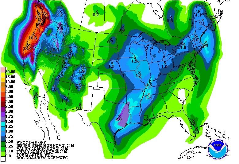
Not in fantasy land, very beneficial rains are on the way for those portions of Texas who are in a severe drought:

1 likes
-
TeamPlayersBlue

- Category 5
- Posts: 3531
- Joined: Tue Feb 02, 2010 1:44 am
- Location: Denver/Applewood, CO
Re: Texas Fall-2016
Loving the setups that the long range is showing us. The -EPO is showing up alot more on the models now. Also, my warm pool which i love to bore you guys with that vanished in the GOA, well its starting to warm again. The warm area that was NW of Hawaii is shifting NE and is beginning to warm the region again. Very very good news and great timing. This will help develop ridges in Alaska.
0 likes
Personal Forecast Disclaimer:
The posts in this forum are NOT official forecast and should not be used as such. They are just the opinion of the poster and may or may not be backed by sound meteorological data. They are NOT endorsed by any professional institution or storm2k.org. For official information, please refer to the NHC and NWS products.
The posts in this forum are NOT official forecast and should not be used as such. They are just the opinion of the poster and may or may not be backed by sound meteorological data. They are NOT endorsed by any professional institution or storm2k.org. For official information, please refer to the NHC and NWS products.
Re: Texas Fall-2016
TeamPlayersBlue wrote:Loving the setups that the long range is showing us. The -EPO is showing up alot more on the models now. Also, my warm pool which i love to bore you guys with that vanished in the GOA, well its starting to warm again. The warm area that was NW of Hawaii is shifting NE and is beginning to warm the region again. Very very good news and great timing. This will help develop ridges in Alaska.
I don't know to what effect this has on us but the Indian Ocean is fairly cool. I don't remember a time its been cool at all, it's been getting warmer and warmer since I have tracked it in general.
0 likes
The above post and any post by Ntxw is NOT an official forecast and should not be used as such. It is just the opinion of the poster and may or may not be backed by sound meteorological data. It is NOT endorsed by any professional institution including Storm2k. For official information, please refer to NWS products.
Help support Storm2K!
Help support Storm2K!
-
TeamPlayersBlue
- Category 5
- Posts: 3531
- Joined: Tue Feb 02, 2010 1:44 am
- Location: Denver/Applewood, CO
Re: Texas Fall-2016
Ntxw wrote:TeamPlayersBlue wrote:Loving the setups that the long range is showing us. The -EPO is showing up alot more on the models now. Also, my warm pool which i love to bore you guys with that vanished in the GOA, well its starting to warm again. The warm area that was NW of Hawaii is shifting NE and is beginning to warm the region again. Very very good news and great timing. This will help develop ridges in Alaska.
I don't know to what effect this has on us but the Indian Ocean is fairly cool. I don't remember a time its been cool at all, it's been getting warmer and warmer since I have tracked it in general.
Would this be an effect from La Nina? With warmer water to its east in the area of Indonesia? Dont know much about the effects from the Indian Ocean. Does it have an effect on the MJO?
0 likes
Personal Forecast Disclaimer:
The posts in this forum are NOT official forecast and should not be used as such. They are just the opinion of the poster and may or may not be backed by sound meteorological data. They are NOT endorsed by any professional institution or storm2k.org. For official information, please refer to the NHC and NWS products.
The posts in this forum are NOT official forecast and should not be used as such. They are just the opinion of the poster and may or may not be backed by sound meteorological data. They are NOT endorsed by any professional institution or storm2k.org. For official information, please refer to the NHC and NWS products.
Re: Texas Fall-2016
TeamPlayersBlue wrote:
Would this be an effect from La Nina? With warmer water to its east in the area of Indonesia? Dont know much about the effects from the Indian Ocean. Does it have an effect on the MJO?
It probably does have an effect on the MJO. I'm not sure if it's ENSO related. It is just something I have not seen before for as long as I have been tracking. You'd have to go back to the 90s I think for any meaningful cool there. The Indian Ocean has been unusually warm for a long time. It may mean something, it may mean not much at all, just a curious observation!
0 likes
The above post and any post by Ntxw is NOT an official forecast and should not be used as such. It is just the opinion of the poster and may or may not be backed by sound meteorological data. It is NOT endorsed by any professional institution including Storm2k. For official information, please refer to NWS products.
Help support Storm2K!
Help support Storm2K!
-
srainhoutx

- S2K Supporter
- Posts: 6919
- Age: 68
- Joined: Sun Jan 14, 2007 11:34 am
- Location: Haywood County, NC
- Contact:
Re: Texas Fall-2016
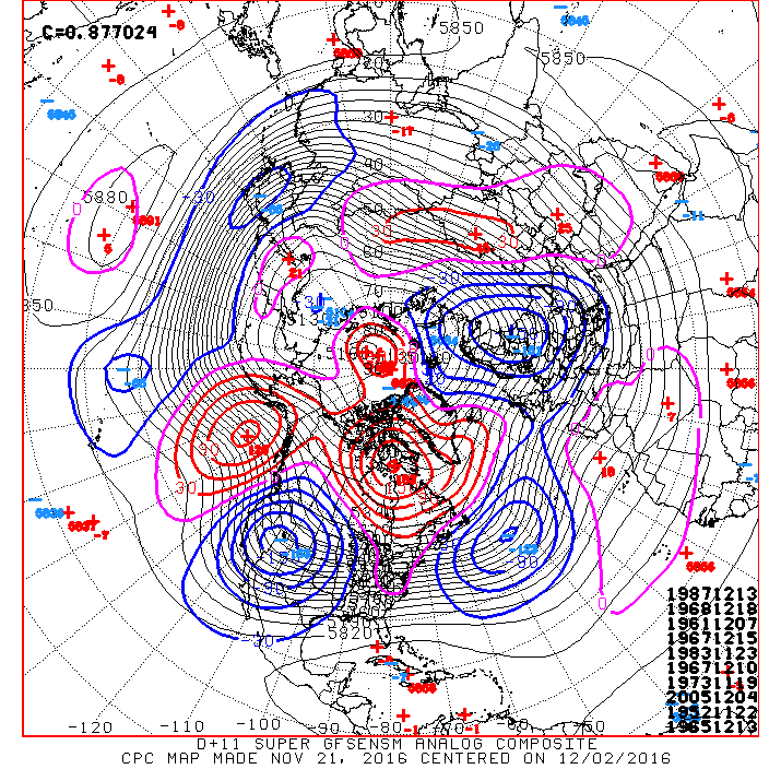
I continue to see encouraging signs via the morning Update GFS Super Ensemble Day 11+ Analogs suggesting a significant pattern change to a colder regime has potential as we transition to the Winter Weather thread.
0 likes
Carla/Alicia/Jerry(In The Eye)/Michelle/Charley/Ivan/Dennis/Katrina/Rita/Wilma/Ike/Harvey
Member: National Weather Association
Wx Infinity Forums
http://wxinfinity.com/index.php
Facebook.com/WeatherInfinity
Twitter @WeatherInfinity
Member: National Weather Association
Wx Infinity Forums
http://wxinfinity.com/index.php
Facebook.com/WeatherInfinity
Twitter @WeatherInfinity
-
TeamPlayersBlue
- Category 5
- Posts: 3531
- Joined: Tue Feb 02, 2010 1:44 am
- Location: Denver/Applewood, CO
Re: Texas Fall-2016
Very interesting. I dont fully understand the dynamics of that area of the globe but if you have never seen it this cool that is interesting. Perhaps La nina is effecting it. Stronger surface high in the southern ocean bringing more Antarctic water northward? Looking at the models, it looks like not much goes on in that region other than the ITCZ. No real upper level highs or lows lol
0 likes
Personal Forecast Disclaimer:
The posts in this forum are NOT official forecast and should not be used as such. They are just the opinion of the poster and may or may not be backed by sound meteorological data. They are NOT endorsed by any professional institution or storm2k.org. For official information, please refer to the NHC and NWS products.
The posts in this forum are NOT official forecast and should not be used as such. They are just the opinion of the poster and may or may not be backed by sound meteorological data. They are NOT endorsed by any professional institution or storm2k.org. For official information, please refer to the NHC and NWS products.
-
TeamPlayersBlue
- Category 5
- Posts: 3531
- Joined: Tue Feb 02, 2010 1:44 am
- Location: Denver/Applewood, CO
Re: Texas Fall-2016
srainhoutx wrote:I continue to see encouraging signs via the morning Update GFS Super Ensemble Day 11+ Analogs suggesting a significant pattern change to a colder regime has potential as we transition to the Winter Weather thread.

I see you lurking 1983....
Ntx, isnt there something called the Indian ocean diopole or something? ( https://en.wikipedia.org/wiki/Indian_Ocean_Dipole )
0 likes
Personal Forecast Disclaimer:
The posts in this forum are NOT official forecast and should not be used as such. They are just the opinion of the poster and may or may not be backed by sound meteorological data. They are NOT endorsed by any professional institution or storm2k.org. For official information, please refer to the NHC and NWS products.
The posts in this forum are NOT official forecast and should not be used as such. They are just the opinion of the poster and may or may not be backed by sound meteorological data. They are NOT endorsed by any professional institution or storm2k.org. For official information, please refer to the NHC and NWS products.
Return to “USA & Caribbean Weather”
Who is online
Users browsing this forum: No registered users and 143 guests