

The north Pacific jet continues to be very strong (Aleutian/GOA low) and has yet to back off flooding the US and much of North America with warmth. We have been beneficiaries of a cutoff upper low that has been trapped by the mid continent ridge downstream of the jet.
You know this is very El Nino like when California continues to get lots of rain. The weak Nina (or Nada) has yet to show up
Texas Fall-2016
Moderator: S2k Moderators
Forum rules

The posts in this forum are NOT official forecast and should not be used as such. They are just the opinion of the poster and may or may not be backed by sound meteorological data. They are NOT endorsed by any professional institution or STORM2K.
Re: Texas Fall-2016
0 likes
The above post and any post by Ntxw is NOT an official forecast and should not be used as such. It is just the opinion of the poster and may or may not be backed by sound meteorological data. It is NOT endorsed by any professional institution including Storm2k. For official information, please refer to NWS products.
Help support Storm2K!
-
Ralph's Weather
- S2K Supporter

- Posts: 3371
- Age: 38
- Joined: Fri Dec 13, 2013 11:55 am
- Location: Lindale, TX
- Contact:
Re: Texas Fall-2016
Today matched the seasonal low at my house with 43. We have been in the 40s 6 or 7 times already. All of East Texas down to Lufkin fell into the 40s with some 30s this morning.
0 likes
Follow on Facebook at Ralph's Weather.
-
Tireman4

- S2K Supporter
- Posts: 5903
- Age: 60
- Joined: Fri Jun 30, 2006 1:08 pm
- Location: Humble, Texas
- Contact:
Re: Texas Fall-2016
hriverajr wrote:Rainy and 60 degrees here in Del Rio, Tx. Feels a bit chillyIt's lovely
Welcome back young man. It has been awhile.
0 likes
-
weatherdude1108
- Category 5

- Posts: 4228
- Joined: Tue Dec 13, 2011 1:04 pm
- Location: Northwest Austin/Cedar Park, TX
Re: Texas Fall-2016
Bob Rose write-up about La Nina:
The latest National Weather Service forecasts call for the current La Niña to remain weak and it should dissipate sometime late winter as tropical Pacific waters warm above the threshold for La Niña. A neutral Pacific is forecast this upcoming spring. Long-range forecasts call for near normal to slightly below normal rainfall across Central Texas during the upcoming spring months. The temperature overall should average milder than normal.
Bob
http://www.lcra.org/water/river-and-weather/weather-summary/pages/bob-rose-on-the-weather.aspx
0 likes
The preceding post is NOT an official forecast, and should not be used as such. It is only the opinion of the poster and may or may not be backed by sound meteorological data. It is NOT endorsed by any professional institution including storm2k.org. For Official Information please refer to the NHC and NWS products.
-
Ralph's Weather
- S2K Supporter
- Posts: 3371
- Age: 38
- Joined: Fri Dec 13, 2013 11:55 am
- Location: Lindale, TX
- Contact:
Re: Texas Fall-2016
weatherdude1108 wrote:Bob Rose write-up about La Nina:
The latest National Weather Service forecasts call for the current La Niña to remain weak and it should dissipate sometime late winter as tropical Pacific waters warm above the threshold for La Niña. A neutral Pacific is forecast this upcoming spring. Long-range forecasts call for near normal to slightly below normal rainfall across Central Texas during the upcoming spring months. The temperature overall should average milder than normal.
Bob
http://www.lcra.org/water/river-and-weather/weather-summary/pages/bob-rose-on-the-weather.aspx
This appears to be a very reasonable forecast once this winter matures. At some point be it, that point keeps being pushed back, this El Nino like pattern will break down and NW flow with periodic cold shots when EPO takes a dip will begin to rule.
0 likes
Follow on Facebook at Ralph's Weather.
Re: Texas Fall-2016
Yeah the issue right now is the El Nino like NPAC pattern refuses to relax. The global angular momentum has stayed higher than normal thus far (more Ninoish) than your typical Nina low angular momentum. The NPAC needs to relax so that ridging can intensify in the GOA
0 likes
The above post and any post by Ntxw is NOT an official forecast and should not be used as such. It is just the opinion of the poster and may or may not be backed by sound meteorological data. It is NOT endorsed by any professional institution including Storm2k. For official information, please refer to NWS products.
Help support Storm2K!
Help support Storm2K!
Re: Texas Fall-2016
Surprisingly though, the other closest La Nada in 1983 did have a fairly stout NPAC jet in early November. Lets see if the same will pan out. In 1983 after the first week of November was able to break through and some cold air was delivered, and the rest was spilled in December when the Pacific reversed course. Whether or not the same happens here is yet to be seen.


We are still lacking anomalous cold air though up north and the stark differences up in Arctic especially the Atlantic side over the Barents/Kara Seas
December 1983. This is why the ridge (yellow blob below the Aleutians and north/northwest of Hawaii) is key. As November rolled into December that blob back then was shoved upwards towards Alaska.
1 likes
The above post and any post by Ntxw is NOT an official forecast and should not be used as such. It is just the opinion of the poster and may or may not be backed by sound meteorological data. It is NOT endorsed by any professional institution including Storm2k. For official information, please refer to NWS products.
Help support Storm2K!
Help support Storm2K!
-
Brent
- S2K Supporter
- Posts: 38755
- Age: 37
- Joined: Sun May 16, 2004 10:30 pm
- Location: Tulsa Oklahoma
- Contact:
Re: Texas Fall-2016
GFS has 30s back next weekend... with some temperatures near freezing outside the metroplex.
0 likes
#neversummer
-
TeamPlayersBlue

- Category 5
- Posts: 3531
- Joined: Tue Feb 02, 2010 1:44 am
- Location: Denver/Applewood, CO
Re: Texas Fall-2016
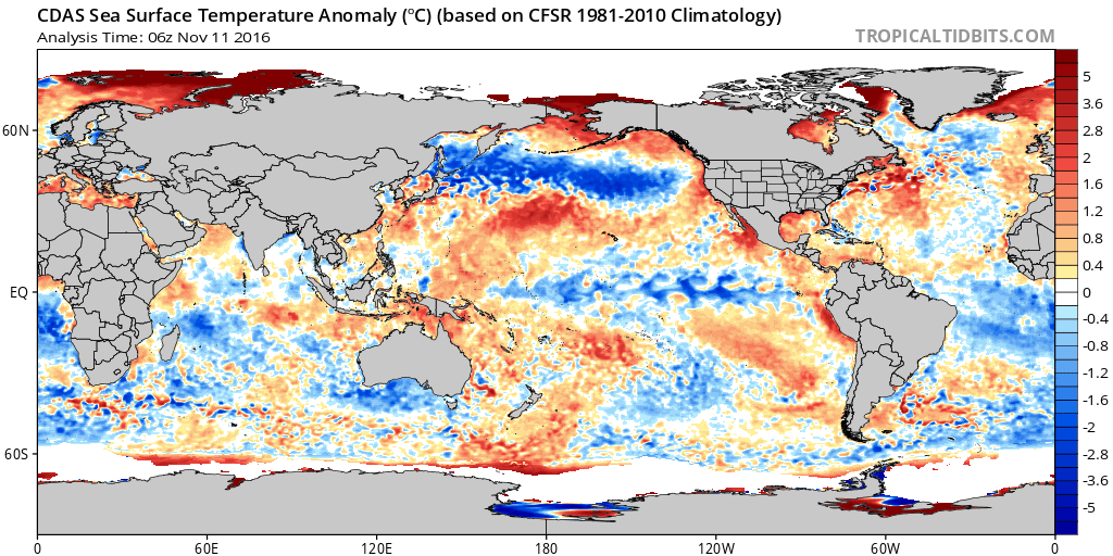
Incredible post Ntx, this is why we have you hahaha. This week i was beginning to worry, but now looking at that analog, its literally identical to Nov '83. That huge blue streak due to the GOA lows has grown massively. The warm blob to the SW of it has grown bigger as well. I think the cool pool is all surface water though, while the warm blob is deeper. Hopefully we get the flip right when it starts to matter.

0 likes
Personal Forecast Disclaimer:
The posts in this forum are NOT official forecast and should not be used as such. They are just the opinion of the poster and may or may not be backed by sound meteorological data. They are NOT endorsed by any professional institution or storm2k.org. For official information, please refer to the NHC and NWS products.
The posts in this forum are NOT official forecast and should not be used as such. They are just the opinion of the poster and may or may not be backed by sound meteorological data. They are NOT endorsed by any professional institution or storm2k.org. For official information, please refer to the NHC and NWS products.
Re: Texas Fall-2016
TeamPlayersBlue wrote:Incredible post Ntx, this is why we have you hahaha. This week i was beginning to worry, but now looking at that analog, its literally identical to Nov '83. That huge blue streak due to the GOA lows has grown massively. The warm blob to the SW of it has grown bigger as well. I think the cool pool is all surface water though, while the warm blob is deeper. Hopefully we get the flip right when it starts to matter.
http://i47.photobucket.com/albums/f192/TeamPlayersblue/cdas-sflux_ssta_global_1%202_zps4iqm1whu.png
I'm always the optimist
That cold tongue in the NPAC did also exist November of 1983. It's almost scary how the Pacific north of the equator resembles it

0 likes
The above post and any post by Ntxw is NOT an official forecast and should not be used as such. It is just the opinion of the poster and may or may not be backed by sound meteorological data. It is NOT endorsed by any professional institution including Storm2k. For official information, please refer to NWS products.
Help support Storm2K!
Help support Storm2K!

Re: Texas Fall-2016
Hey guys. I'm from ne Arkansas. Got a question for ntxw. I know the Pacific hasn't been cooperating. Also, all the cold is overseas. Do we need a big GOA ridge to allow for that possibility? The PV splitting and displacing has sent it all the wrong location. Ntwx, do you think the Pacific will even be conducive to get cross polar flow established to tap that? I know the epo is supposed to turn negative based on forecasts. 
0 likes
Re: Texas Fall-2016
I need your help, what is the GOA ridge and how does it effect weather? Trying to learn.
0 likes
Re: Texas Fall-2016
Golf7070 wrote:Hey guys. I'm from ne Arkansas. Got a question for ntxw. I know the Pacific hasn't been cooperating. Also, all the cold is overseas. Do we need a big GOA ridge to allow for that possibility? The PV splitting and displacing has sent it all the wrong location. Ntwx, do you think the Pacific will even be conducive to get cross polar flow established to tap that? I know the epo is supposed to turn negative based on forecasts.
Splitting the PV is important in keeping the mid latitudes cold vs bottling all of it in the Arctic. Aside from that the Pacific also plays an important role for North America. If the La Nina can assert itself a little bit, the Pacific jet will slow and retract and allow ridging to block incoming Pacific air, shifting our flow coming from Canada and even Siberia. I think it will happen eventually because the ocean is Ninaish but the atmosphere has not responded yet.
gto67 wrote:I need your help, what is the GOA ridge and how does it effect weather? Trying to learn.
GOA ridge is blocking in the northeast Pacific or -EPO. Ridging here is a block that prevents warm,moist Pacific air from reaching North America and allow cross polar flow. A GOA low is the opposite pattern and floods North America with warmth and a wet pattern in the northwest.
0 likes
The above post and any post by Ntxw is NOT an official forecast and should not be used as such. It is just the opinion of the poster and may or may not be backed by sound meteorological data. It is NOT endorsed by any professional institution including Storm2k. For official information, please refer to NWS products.
Help support Storm2K!
Help support Storm2K!
Re: Texas Fall-2016
Ntxw wrote:Golf7070 wrote:Hey guys. I'm from ne Arkansas. Got a question for ntxw. I know the Pacific hasn't been cooperating. Also, all the cold is overseas. Do we need a big GOA ridge to allow for that possibility? The PV splitting and displacing has sent it all the wrong location. Ntwx, do you think the Pacific will even be conducive to get cross polar flow established to tap that? I know the epo is supposed to turn negative based on forecasts.
Splitting the PV is important in keeping the mid latitudes cold vs bottling all of it in the Arctic. Aside from that the Pacific also plays an important role for North America. If the La Nina can assert itself a little bit, the Pacific jet will slow and retract and allow ridging to block incoming Pacific air, shifting our flow coming from Canada and even Siberia. I think it will happen eventually because the ocean is Ninaish but the atmosphere has not responded yet.gto67 wrote:I need your help, what is the GOA ridge and how does it effect weather? Trying to learn.
GOA ridge is blocking in the northeast Pacific or -EPO. Ridging here is a block that prevents warm,moist Pacific air from reaching North America and allow cross polar flow. A GOA low is the opposite pattern and floods North America with warmth and a wet pattern in the northwest.
Ntwx, Mike ventrice mentioned that the atmosphere is finally starting to act like niña. Not sure if it's true or not. Do you agree with forecasts of epo going negative?
0 likes
Re: Texas Fall-2016
Golf7070 wrote:Ntwx, Mike ventrice mentioned that the atmosphere is finally starting to act like niña. Not sure if it's true or not. Do you agree with forecasts of epo going negative?
Forecasts do show a global decline of the Angular Momentum so that is supportive of weakening the jet and more Nina-like weather across the globe. Dec-Jan-Feb is usually the period when an ENSO event does mature the most so I generally would agree. If it does then we can see an upper pattern more like 1983-1984. If it does not then we keep heights low over the GOA and Alaska then we have a 2011-2012 situation with zonal flow all the time.
0 likes
The above post and any post by Ntxw is NOT an official forecast and should not be used as such. It is just the opinion of the poster and may or may not be backed by sound meteorological data. It is NOT endorsed by any professional institution including Storm2k. For official information, please refer to NWS products.
Help support Storm2K!
Help support Storm2K!
Re: Texas Fall-2016
I know the models that I saw are showing -epo and ensembles. If it's correct obviously
0 likes
Re: Texas Fall-2016
Ryan Maue tweeted this. Wouldn't it be fun to have that 1070+ in NW Canada crossing over from Siberia? Fall in Asia and Europe has been unusually cold.
https://twitter.com/RyanMaue/status/797237146713280512
https://twitter.com/RyanMaue/status/797237146713280512
0 likes
The above post and any post by Ntxw is NOT an official forecast and should not be used as such. It is just the opinion of the poster and may or may not be backed by sound meteorological data. It is NOT endorsed by any professional institution including Storm2k. For official information, please refer to NWS products.
Help support Storm2K!
Help support Storm2K!
-
Brent
- S2K Supporter
- Posts: 38755
- Age: 37
- Joined: Sun May 16, 2004 10:30 pm
- Location: Tulsa Oklahoma
- Contact:
Re: Texas Fall-2016
Finally seeing signs of colder air on the GFS... after the 80s return briefly Wednesday, it appears the bottom falls out. The 0z GFS has sub-540 thickness next weekend and lows in the 30s around DFW...highs may not get out of the 50s... and it continues to look a lot chillier leading up to Thanksgiving. Not much rain though...
0 likes
#neversummer
Re: Texas Fall-2016
Brent wrote:Finally seeing signs of colder air on the GFS... after the 80s return briefly Wednesday, it appears the bottom falls out. The 0z GFS has sub-540 thickness next weekend and lows in the 30s around DFW...highs may not get out of the 50s... and it continues to look a lot chillier leading up to Thanksgiving. Not much rain though...
Some of the local 10 day outlooks are reflecting this. Finally some light at the end of the tunnel. Autumn has been an arduous, frustrating wait this year.
0 likes
Return to “USA & Caribbean Weather”
Who is online
Users browsing this forum: Greener, South Texas Storms, Stratton23, TomballEd and 132 guests