ATL: MATTHEW - Post-Tropical - Discussion

Moderator: S2k Moderators

Message
Author
dukeblue219
S2K Supporter
S2K Supporter
Posts: 535
Joined: Fri Sep 30, 2016 3:52 pm

Re: ATL: MATTHEW - Hurricane - Discussion

#10401 Postby dukeblue219 » Fri Oct 07, 2016 3:18 pm

KWT wrote:Matthew still has a decent structure but clearly is a weakening system.

Everyone stay safe!


Recon is still extrapolating 947mb in the center. The winds are surely down from yesterday, but the hurricane itself is maintaining a pretty low pressure.
0 likes   

JarrodB

Re: ATL: MATTHEW - Hurricane - Discussion

#10402 Postby JarrodB » Fri Oct 07, 2016 3:20 pm

delta lady wrote:Large section of the Jacksonville Beach Pier just broke off.


Hopefully we can get some pictures soon . I believe Floyd in 99 took out the old pier.
0 likes   

User avatar
ronjon
Category 5
Category 5
Posts: 4822
Joined: Fri Aug 19, 2005 5:17 pm
Location: Hernando Beach, FL

Re: ATL: MATTHEW - Hurricane - Discussion

#10403 Postby ronjon » Fri Oct 07, 2016 3:21 pm

dukeblue219 wrote:
KWT wrote:Matthew still has a decent structure but clearly is a weakening system.

Everyone stay safe!


Recon is still extrapolating 947mb in the center. The winds are surely down from yesterday, but the hurricane itself is maintaining a pretty low pressure.


And expanding wind field.
0 likes   

Sanibel
Category 5
Category 5
Posts: 10375
Joined: Mon Aug 30, 2004 11:06 pm
Location: Offshore SW Florida

Re: ATL: MATTHEW - Hurricane - Discussion

#10404 Postby Sanibel » Fri Oct 07, 2016 3:26 pm

A typical surger...
0 likes   

User avatar
northjaxpro
S2K Supporter
S2K Supporter
Posts: 8900
Joined: Mon Sep 27, 2010 11:21 am
Location: Jacksonville, FL

Re: ATL: MATTHEW - Hurricane - Discussion

#10405 Postby northjaxpro » Fri Oct 07, 2016 3:26 pm

Yeah the end of the Pier was ripped off. WOW. Watching live coverage on TV-4.
1 likes   
NEVER, EVER SAY NEVER in the tropics and weather in general, and most importantly, with life itself!!

________________________________________________________________________________________

Fay 2008 Beryl 2012 Debby 2012 Colin 2016 Hermine 2016 Julia 2016 Matthew 2016 Irma 2017 Dorian 2019

ThetaE
Tropical Storm
Tropical Storm
Posts: 244
Joined: Sat Sep 24, 2016 4:50 pm
Location: Boston

Re: ATL: MATTHEW - Hurricane - Discussion

#10406 Postby ThetaE » Fri Oct 07, 2016 3:28 pm

ronjon wrote:
dukeblue219 wrote:
KWT wrote:Matthew still has a decent structure but clearly is a weakening system.

Everyone stay safe!


Recon is still extrapolating 947mb in the center. The winds are surely down from yesterday, but the hurricane itself is maintaining a pretty low pressure.


And expanding wind field.


This. The worry shouldn't be the strongest winds in this storm; they're mostly concentrated to a smaller area, and offshore on the NE side regardless. An expanding wind field, however, increases the overall risk/damage of the storm as it will impact many more people.
0 likes   
I'm a busy grad student, not a professional forecaster. Please refer to the NHC and NWS for official forecasts.

User avatar
alan1961
Category 2
Category 2
Posts: 771
Joined: Mon Mar 20, 2006 11:58 am
Location: Derby, Derbyshire, England
Contact:

Re: ATL: MATTHEW - Hurricane - Discussion

#10407 Postby alan1961 » Fri Oct 07, 2016 3:28 pm

From various camera angles from ISS

Image

Image

Image
0 likes   

User avatar
Tireman4
S2K Supporter
S2K Supporter
Posts: 5853
Age: 59
Joined: Fri Jun 30, 2006 1:08 pm
Location: Humble, Texas
Contact:

Re: ATL: MATTHEW - Hurricane - Discussion

#10408 Postby Tireman4 » Fri Oct 07, 2016 3:30 pm

Never underestimate the power of wind and water...
3 likes   

User avatar
northjaxpro
S2K Supporter
S2K Supporter
Posts: 8900
Joined: Mon Sep 27, 2010 11:21 am
Location: Jacksonville, FL

Re: ATL: MATTHEW - Hurricane - Discussion

#10409 Postby northjaxpro » Fri Oct 07, 2016 3:35 pm

JarrodB wrote:
delta lady wrote:Large section of the Jacksonville Beach Pier just broke off.


Hopefully we can get some pictures soon . I believe Floyd in 99 took out the old pier.


Yes, Floyd took out that old wooden pier in 1999. Impressive that this pier was supposed to have been a new and improved concerte pier. That shows the power of Mother Nature with a Cat 3 major hurricane pounding your coastline .
0 likes   
NEVER, EVER SAY NEVER in the tropics and weather in general, and most importantly, with life itself!!

________________________________________________________________________________________

Fay 2008 Beryl 2012 Debby 2012 Colin 2016 Hermine 2016 Julia 2016 Matthew 2016 Irma 2017 Dorian 2019

User avatar
ronjon
Category 5
Category 5
Posts: 4822
Joined: Fri Aug 19, 2005 5:17 pm
Location: Hernando Beach, FL

Re: ATL: MATTHEW - Hurricane - Discussion

#10410 Postby ronjon » Fri Oct 07, 2016 3:39 pm

ThetaE wrote:
ronjon wrote:
dukeblue219 wrote:
Recon is still extrapolating 947mb in the center. The winds are surely down from yesterday, but the hurricane itself is maintaining a pretty low pressure.


And expanding wind field.


This. The worry shouldn't be the strongest winds in this storm; they're mostly concentrated to a smaller area, and offshore on the NE side regardless. An expanding wind field, however, increases the overall risk/damage of the storm as it will impact many more people.


And increases the area of surge.
0 likes   

User avatar
northjaxpro
S2K Supporter
S2K Supporter
Posts: 8900
Joined: Mon Sep 27, 2010 11:21 am
Location: Jacksonville, FL

Re: ATL: MATTHEW - Hurricane - Discussion

#10411 Postby northjaxpro » Fri Oct 07, 2016 3:40 pm

northjaxpro wrote:
JarrodB wrote:
delta lady wrote:Large section of the Jacksonville Beach Pier just broke off.


Hopefully we can get some pictures soon . I believe Floyd in 99 took out the old pier.


Yes, Floyd took out that old wooden pier in 1999. Impressive that this pier was supposed to have been a new and improved concrete pier. That shows the power of Mother Nature with a Cat 3 major hurricane pounding your coastline .
0 likes   
NEVER, EVER SAY NEVER in the tropics and weather in general, and most importantly, with life itself!!

________________________________________________________________________________________

Fay 2008 Beryl 2012 Debby 2012 Colin 2016 Hermine 2016 Julia 2016 Matthew 2016 Irma 2017 Dorian 2019

User avatar
jasons2k
Storm2k Executive
Storm2k Executive
Posts: 8245
Age: 51
Joined: Wed Jul 06, 2005 12:32 pm
Location: The Woodlands, TX

ATL: MATTHEW - Hurricane - Discussion

#10412 Postby jasons2k » Fri Oct 07, 2016 3:44 pm

From Jeff lindner - sorry can't reformat on Tapatalk but wanted to get this out. I feel for my old friends and neighbors in Savannah:

Near record storm surge event underway over NE FL and GA

Life threatening potentially historic storm surge for the GA and SC coasts tonight and Saturday

Matthew pounds the east coast of FL with 70-90mph winds and massive storm surge causing extensive damage.

Discussion:
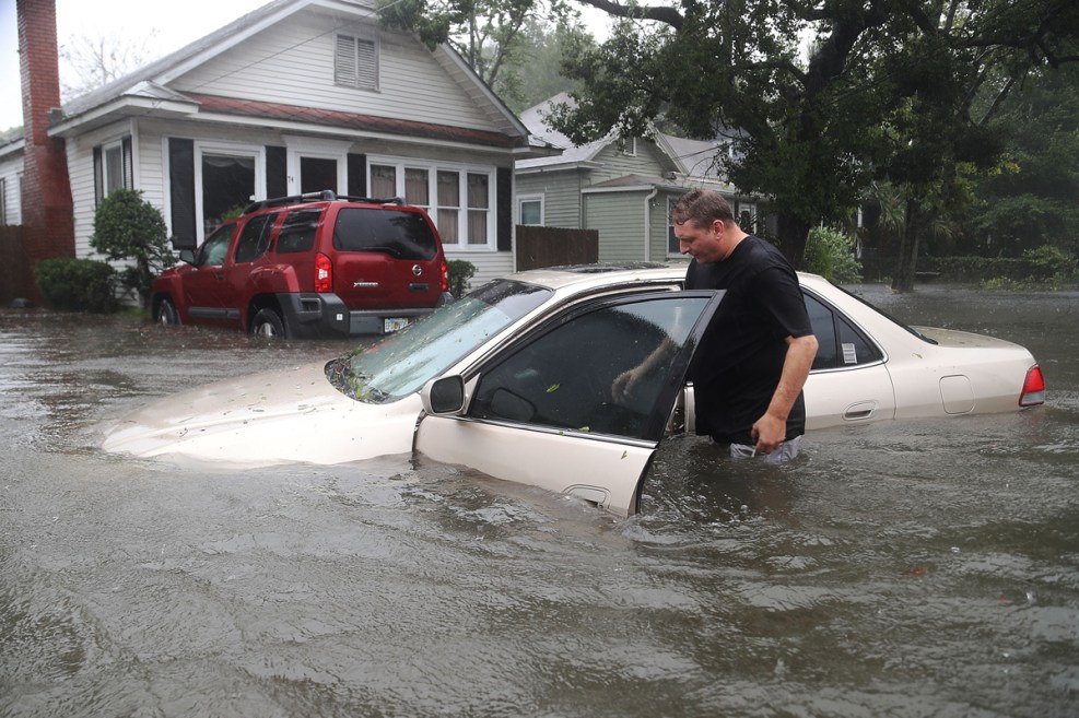
The eye of major hurricane Matthew with sustained winds of 115mph is located roughly 45 ESE of Jacksonville Beach. St Augustin has been gusting to 76mph in the last hour and Jacksonville Intl Airport 64mph. Major storm surge flooding is in progress currently from St Augustine to Jacksonville. At St Augustine the seawall has been overtopped and sea water has flooded much of the city. At both Jacksonville and Daytona Beach the dunes were breached and waves and storm surge poured into the structures on the land side of the dunes. Significant storm surge flooding is in progress in the St John’s River in Downtown Jacksonville. The entire island of Anastasia has been covered with 2.5-3.0 feet of sea water. Several large sections of highway A1A at Flagler Beach have collapsed and wind damage to structures is significant in Daytona Beach where large sections of high rise buildings were torn off.

Matthew has turned 350 degree at 14 mph and this motion should continue for the next several hours with a turn toward the NNE and NE which will now bring the center to the SC coast just SW of Charleston, SC. The hurricane may weaken below major hurricane status late tonight or early on Saturday, but the large wind field and the extreme vulnerability of the GA and SC to storm surge will result in a significant if not historic event.

Impacts:

Life threatening storm surge in progress along the NE FL coast will spread northward into all of the GA and much of the SC coasts tonight and Saturday.

Potential for record storm surge values at St Simon Island, Tybee Island, and Savannah tonight.

Concern is growing that a large and devastating storm surge will impact Charleston, Folly Beach and Beaufort Saturday as the large center of Matthew nears of makes landfall over southwest SC. This will be a devastating storm surge event for the GA and SC coast with extensive damage likely to coastal structures.

Storm surge values above the ground tonight and Saturday will range from 6-9 ft from GA to SC including portions of Downtown Savannah, portions of Charleston and Hilton Head, SC. Much of Tybee Island will be impacted by storm surge along with nearly all of Folly Beach. As seen today in FL the large battering waves of 5-10 ft on top of the storm surge will result in massive beach erosion and collapse of coastal structures. Based on the current storm surge forecast….overtopping of the seawall around Downtown Charleston is likely allowing large battering waves to be driven directly into the historic portions of the city.

As seen today…people that have not taken the evacuation orders seriously have become trapped by the rising sea water on barrier islands and forced to move to higher floors…the threat along the GA and SC coast is much more significant as the storm surge will move further inland as the terrain rise is not as steep as the NE FL coast.

Winds
Expect sustained winds of 60-90mph to continue this evening along the NE FL coast and then spread into the GA coast overnight. Winds along the SC coast will increase into the 70-80mph range early Saturday and likely peak near 80-100mph Saturday midday into Saturday evening. Much more wind energy may reach the SC coast compared to the FL coast as the northern eyewall which has been very strong is likely to actually cross the coastline. Signifcaint wind damage is likely across much of coastal SC from Matthew.

Rainfall:
Rainfall is becoming a much bigger concern northward over SC and NC where Matthew will interact with the upper level jet stream which will help to focus excessive rainfall just inland from the coast. Rainfall amounts of 8-15 inches will be possible which will lead to significant fresh water flooding.

A reminder that the most likely cause of death in any hurricane is flooding from either storm surge or rainfall.


[Image of 5-day forecast and coastal areas under a warning or a watch]

Click for latest Base Reflectivity radar loop from the Jacksonville, FL radar and current weather warnings


Daytona Beach
Hurricane Matthew

Titusville
Hurricane Matthew

Daytona Beach (FL side of intercoastal)
Hurricane Matthew

St Augustine (Storm surge flooding)
http://media.nbcmiami.com/images/987*65 ... 98-hur.jpg
1 likes   

tolakram
Admin
Admin
Posts: 20009
Age: 62
Joined: Sun Aug 27, 2006 8:23 pm
Location: Florence, KY (name is Mark)

Re: ATL: MATTHEW - Hurricane - Discussion

#10413 Postby tolakram » Fri Oct 07, 2016 3:45 pm

Going north again, I was really hoping it would move NE for a while but it was just a wobble.

Image
1 likes   
M a r k
- - - - -
Join us in chat: Storm2K Chatroom Invite. Android and IOS apps also available.

The posts in this forum are NOT official forecasts and should not be used as such. Posts are NOT endorsed by any professional institution or STORM2K.org. For official information and forecasts, please refer to NHC and NWS products.

tolakram
Admin
Admin
Posts: 20009
Age: 62
Joined: Sun Aug 27, 2006 8:23 pm
Location: Florence, KY (name is Mark)

Re: ATL: MATTHEW - Hurricane - Discussion

#10414 Postby tolakram » Fri Oct 07, 2016 3:47 pm

Image
0 likes   
M a r k
- - - - -
Join us in chat: Storm2K Chatroom Invite. Android and IOS apps also available.

The posts in this forum are NOT official forecasts and should not be used as such. Posts are NOT endorsed by any professional institution or STORM2K.org. For official information and forecasts, please refer to NHC and NWS products.

swampgator92

Re: ATL: MATTHEW - Hurricane - Discussion

#10415 Postby swampgator92 » Fri Oct 07, 2016 3:51 pm

Extensive storm surge damage at Flagler College in St. Augustine.

 https://twitter.com/ActionNewsJax/status/784491181245857792


0 likes   

tolakram
Admin
Admin
Posts: 20009
Age: 62
Joined: Sun Aug 27, 2006 8:23 pm
Location: Florence, KY (name is Mark)

Re: ATL: MATTHEW - Hurricane - Discussion

#10416 Postby tolakram » Fri Oct 07, 2016 3:54 pm

1 likes   
M a r k
- - - - -
Join us in chat: Storm2K Chatroom Invite. Android and IOS apps also available.

The posts in this forum are NOT official forecasts and should not be used as such. Posts are NOT endorsed by any professional institution or STORM2K.org. For official information and forecasts, please refer to NHC and NWS products.

ThetaE
Tropical Storm
Tropical Storm
Posts: 244
Joined: Sat Sep 24, 2016 4:50 pm
Location: Boston

Re: ATL: MATTHEW - Hurricane - Discussion

#10417 Postby ThetaE » Fri Oct 07, 2016 3:56 pm

Not that it matters much in terms of impact, but Matthew's down to 95 kt at 5 PM. How long of a major hurricane streak was that? A week?
0 likes   
I'm a busy grad student, not a professional forecaster. Please refer to the NHC and NWS for official forecasts.

jlauderdal
S2K Supporter
S2K Supporter
Posts: 7183
Joined: Wed May 19, 2004 5:46 am
Location: NE Fort Lauderdale
Contact:

Re: ATL: MATTHEW - Hurricane - Discussion

#10418 Postby jlauderdal » Fri Oct 07, 2016 4:01 pm

swampgator92 wrote:Extensive storm surge damage at Flagler College in St. Augustine.

 https://twitter.com/ActionNewsJax/status/784491181245857792


been in that area many times...flagler college is several block inalnd
0 likes   

User avatar
LCfromFL
Category 1
Category 1
Posts: 257
Joined: Wed Aug 11, 2004 11:17 pm
Location: NE FL

Re: ATL: MATTHEW - Hurricane - Discussion

#10419 Postby LCfromFL » Fri Oct 07, 2016 4:01 pm

northjaxpro wrote:Yeah the end of the Pier was ripped off. WOW. Watching live coverage on TV-4.


Me too! Our power has blinked a few times, but hasn't gone out totally <crossing fingers>. My kiddos keep showing me pics and videos from social media. Flooding at Flagler College - water cascading down a set of stairs...water in the streets. Just heard 156,000 JEA customers are out of power from 1,300 separate outages. :eek:
0 likes   

jlauderdal
S2K Supporter
S2K Supporter
Posts: 7183
Joined: Wed May 19, 2004 5:46 am
Location: NE Fort Lauderdale
Contact:

Re: ATL: MATTHEW - Hurricane - Discussion

#10420 Postby jlauderdal » Fri Oct 07, 2016 4:06 pm

Se florida more in the cone than we ever were a few days ago...October is prime time for florida
1 likes   


Return to “2016”

Who is online

Users browsing this forum: No registered users and 6 guests