ATL: MATTHEW - Models

Moderator: S2k Moderators

Message
Author
User avatar
bg1
Category 1
Category 1
Posts: 409
Joined: Fri May 13, 2011 11:14 am
Location: near Santee, SC

Re: ATL: MATTHEW - Models

#7261 Postby bg1 » Wed Oct 05, 2016 11:15 pm

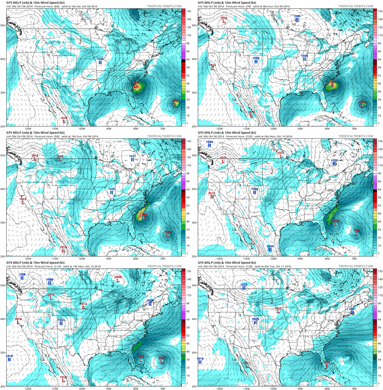
From 66 - 126 (or about 3 - 5 days out):
Image

A weaker Matt gets tired of dancing with Nicole and tries to break away, but takes her west with him as he makes landfall a second time.
0 likes   

User avatar
Blinhart
Category 5
Category 5
Posts: 2079
Age: 48
Joined: Thu Sep 08, 2011 3:13 pm
Location: Crowley, La.

Re: ATL: MATTHEW - Models

#7262 Postby Blinhart » Wed Oct 05, 2016 11:21 pm

bg1 wrote:From 66 - 126 (or about 3 - 5 days out):
Image

A weaker Matt gets tired of dancing with Nicole and tries to break away, but takes her west with him as he makes landfall a second time.


And continues into the hot tub of the GoM, that could be a serious problem.
2 likes   
Personal Forecast Disclaimer:
The posts in this forum are NOT official forecast and should not be used as such. They are just the opinion of the poster and may or may not be backed by sound meteorological data. They are NOT endorsed by any professional institution or storm2k.org. For official information, please refer to the NHC and NWS products.

Alyono
Professional-Met
Professional-Met
Posts: 6961
Joined: Fri Apr 26, 2013 3:52 pm
Location: Texas Coast

Re: ATL: MATTHEW - Models

#7263 Postby Alyono » Wed Oct 05, 2016 11:23 pm

GLOBAL MODEL DATA TIME 0000UTC 06.10.2016

HURRICANE MATTHEW ANALYSED POSITION : 23.1N 76.1W

ATCF IDENTIFIER : AL142016

LEAD CENTRAL MAXIMUM WIND
VERIFYING TIME TIME POSITION PRESSURE (MB) SPEED (KNOTS)
-------------- ---- -------- ------------- -------------
0000UTC 06.10.2016 0 23.1N 76.1W 983 52
1200UTC 06.10.2016 12 24.7N 77.6W 980 55
0000UTC 07.10.2016 24 26.4N 79.4W 974 58
1200UTC 07.10.2016 36 28.6N 80.4W 972 56
0000UTC 08.10.2016 48 30.5N 80.9W 971 58
1200UTC 08.10.2016 60 32.4N 80.2W 969 59
0000UTC 09.10.2016 72 33.1N 78.0W 984 58
1200UTC 09.10.2016 84 33.9N 75.9W 989 55
0000UTC 10.10.2016 96 33.3N 73.2W 995 53
1200UTC 10.10.2016 108 32.9N 71.8W 1000 48
0000UTC 11.10.2016 120 CEASED TRACKING
1 likes   

User avatar
bg1
Category 1
Category 1
Posts: 409
Joined: Fri May 13, 2011 11:14 am
Location: near Santee, SC

Re: ATL: MATTHEW - Models

#7264 Postby bg1 » Wed Oct 05, 2016 11:23 pm

144 - 162: Heading SW toward the Yucatan at a good clip! Three runs in a row now the GFS has shown it getting near the Yucatan/Cuba area.
0 likes   

User avatar
Bocadude85
Category 5
Category 5
Posts: 2991
Age: 38
Joined: Mon Apr 18, 2005 2:20 pm
Location: Honolulu,Hi

Re: ATL: MATTHEW - Models

#7265 Postby Bocadude85 » Wed Oct 05, 2016 11:24 pm

Alyono wrote:GLOBAL MODEL DATA TIME 0000UTC 06.10.2016

HURRICANE MATTHEW ANALYSED POSITION : 23.1N 76.1W

ATCF IDENTIFIER : AL142016

LEAD CENTRAL MAXIMUM WIND
VERIFYING TIME TIME POSITION PRESSURE (MB) SPEED (KNOTS)
-------------- ---- -------- ------------- -------------
0000UTC 06.10.2016 0 23.1N 76.1W 983 52
1200UTC 06.10.2016 12 24.7N 77.6W 980 55
0000UTC 07.10.2016 24 26.4N 79.4W 974 58
1200UTC 07.10.2016 36 28.6N 80.4W 972 56
0000UTC 08.10.2016 48 30.5N 80.9W 971 58
1200UTC 08.10.2016 60 32.4N 80.2W 969 59
0000UTC 09.10.2016 72 33.1N 78.0W 984 58
1200UTC 09.10.2016 84 33.9N 75.9W 989 55
0000UTC 10.10.2016 96 33.3N 73.2W 995 53
1200UTC 10.10.2016 108 32.9N 71.8W 1000 48
0000UTC 11.10.2016 120 CEASED TRACKING


That's a west shift in the short term..this is going to be real close to Palm Beach County
0 likes   

User avatar
SouthFloridawx
S2K Supporter
S2K Supporter
Posts: 8346
Age: 46
Joined: Tue Jul 26, 2005 1:16 am
Location: Sarasota, FL
Contact:

Re: ATL: MATTHEW - Models

#7266 Postby SouthFloridawx » Wed Oct 05, 2016 11:27 pm

Nothing say''s I don't care anymore like, "ceased tracking".
Alyono wrote:GLOBAL MODEL DATA TIME 0000UTC 06.10.2016
HURRICANE MATTHEW ANALYSED POSITION : 23.1N 76.1W
ATCF IDENTIFIER : AL142016
LEAD CENTRAL MAXIMUM WIND
VERIFYING TIME TIME POSITION PRESSURE (MB) SPEED (KNOTS)
-------------- ---- -------- ------------- -------------
0000UTC 06.10.2016 0 23.1N 76.1W 983 52
1200UTC 06.10.2016 12 24.7N 77.6W 980 55
0000UTC 07.10.2016 24 26.4N 79.4W 974 58
1200UTC 07.10.2016 36 28.6N 80.4W 972 56
0000UTC 08.10.2016 48 30.5N 80.9W 971 58
1200UTC 08.10.2016 60 32.4N 80.2W 969 59
0000UTC 09.10.2016 72 33.1N 78.0W 984 58
1200UTC 09.10.2016 84 33.9N 75.9W 989 55
0000UTC 10.10.2016 96 33.3N 73.2W 995 53
1200UTC 10.10.2016 108 32.9N 71.8W 1000 48
0000UTC 11.10.2016 120 CEASED TRACKING
5 likes   

User avatar
SouthernBreeze
Category 1
Category 1
Posts: 284
Age: 68
Joined: Tue Aug 31, 2004 4:54 pm
Location: SC/NC line- on the SC Coast

Re: ATL: MATTHEW - Models

#7267 Postby SouthernBreeze » Wed Oct 05, 2016 11:27 pm

and 33.1N 78.0W pretty darn close to SC/NC line. hoping it weakens by then!
0 likes   
My posts are NOT official forecast and should not be used as such. It's just my opinion and not backed by sound meteorological data, and NOT endorsed by any professional institution or storm2k.org. For official information, please refer to the NHC and NWS products.

grazed by many - most wind damage: Hugo (pre-cellphone days!) & most water: Floyd

User avatar
Steve
S2K Supporter
S2K Supporter
Posts: 9621
Joined: Sat Apr 05, 2003 11:41 pm
Location: Not a state-caster

Re: ATL: MATTHEW - Models

#7268 Postby Steve » Wed Oct 05, 2016 11:29 pm

NAM low res outputs sort of jog north when they get toward South Florida with the worst of the weather north of Metro Miami. However, the 4K specifically brings the front side and worst weather since probably Cuba to South Carolina. I wouldn't call it the Right Front Quadrant but maybe the North 1/2.

http://www.tropicaltidbits.com/analysis ... 0&ypos=200
Last edited by Steve on Wed Oct 05, 2016 11:37 pm, edited 2 times in total.
0 likes   

User avatar
SouthernBreeze
Category 1
Category 1
Posts: 284
Age: 68
Joined: Tue Aug 31, 2004 4:54 pm
Location: SC/NC line- on the SC Coast

Re: ATL: MATTHEW - Models

#7269 Postby SouthernBreeze » Wed Oct 05, 2016 11:32 pm

WOW! although NAM not the most reliable?
0 likes   
My posts are NOT official forecast and should not be used as such. It's just my opinion and not backed by sound meteorological data, and NOT endorsed by any professional institution or storm2k.org. For official information, please refer to the NHC and NWS products.

grazed by many - most wind damage: Hugo (pre-cellphone days!) & most water: Floyd

User avatar
Steve
S2K Supporter
S2K Supporter
Posts: 9621
Joined: Sat Apr 05, 2003 11:41 pm
Location: Not a state-caster

Re: ATL: MATTHEW - Models

#7270 Postby Steve » Wed Oct 05, 2016 11:36 pm

SouthernBreeze wrote:WOW! although NAM not the most reliable?


The lower resolutions pick up pretty good upper features in the subtropics and temperate regions. The 4K usually deviates from the 32 and whatever the other resolution Levi (c) has on his site a little, but since it's a much tighter resolution, I'll watch it sometimes. The radar products can be good or they can be sketchy. But seeing as where you live, that looks like a decent pounding, and since the storm doesn't really hook east but up the coast, there's a shot for some prolonged damaging winds and rainfall from NE GA all the way across coastal South Carolina if it's even close to being right. You have a couple of days to react still, but I'd be at the store about 6am tomorrow getting everything I needed before you have to wait in lines and **** runs out.
0 likes   

Alyono
Professional-Met
Professional-Met
Posts: 6961
Joined: Fri Apr 26, 2013 3:52 pm
Location: Texas Coast

Re: ATL: MATTHEW - Models

#7271 Postby Alyono » Wed Oct 05, 2016 11:38 pm

Canadian model has a Florida landfall
1 likes   

User avatar
Steve
S2K Supporter
S2K Supporter
Posts: 9621
Joined: Sat Apr 05, 2003 11:41 pm
Location: Not a state-caster

Re: ATL: MATTHEW - Models

#7272 Postby Steve » Wed Oct 05, 2016 11:41 pm

Also, GFS buries remnants of Matthew down in the Bay of Campeche at least by 222 hours (9 1/2 days). You'd have to think, if you've been thinking like me, that if it can hit that part of the 1995 analog, maybe something comes back up NE to hit Alabama or Florida late in the season to usher in Fall 2016 to the Southeast. Not sure this would completely degenerate unless upper conditions won't allow for continued maintenance or else intensification if it came back north across the Loop Current (ala Opal).

I'm curious to see what the rest of the run does, but I suspect it probably continues to weaken it or just forces it down into Mexico.
Last edited by Steve on Wed Oct 05, 2016 11:49 pm, edited 1 time in total.
0 likes   

User avatar
Bocadude85
Category 5
Category 5
Posts: 2991
Age: 38
Joined: Mon Apr 18, 2005 2:20 pm
Location: Honolulu,Hi

Re: ATL: MATTHEW - Models

#7273 Postby Bocadude85 » Wed Oct 05, 2016 11:43 pm

Through 21 hours the 0z HWRF is west of the 18Z just offshore Palm Beach
1 likes   

User avatar
tarheelprogrammer
S2K Supporter
S2K Supporter
Posts: 1793
Joined: Mon Mar 28, 2016 9:25 pm
Location: Raleigh, NC area (Garner, NC)

Re: ATL: MATTHEW - Models

#7274 Postby tarheelprogrammer » Wed Oct 05, 2016 11:43 pm

Is UKMET threatening to Wilmington area this run?
0 likes   
My posts are not official forecasts. They are just my opinion and may or may not be backed by sound meteorological data. They are NOT endorsed by any professional institution or storm2k.org. For official information, please refer to the NHC and NWS products.

User avatar
Steve
S2K Supporter
S2K Supporter
Posts: 9621
Joined: Sat Apr 05, 2003 11:41 pm
Location: Not a state-caster

Re: ATL: MATTHEW - Models

#7275 Postby Steve » Wed Oct 05, 2016 11:45 pm

Alyono wrote:Canadian model has a Florida landfall


It elongates on Pass #2 and spits out a piece that circles back around and hits between Port Charlotte or Ft. Meyers while the main energy reverses and goes back out to sea.
0 likes   

User avatar
Bocadude85
Category 5
Category 5
Posts: 2991
Age: 38
Joined: Mon Apr 18, 2005 2:20 pm
Location: Honolulu,Hi

Re: ATL: MATTHEW - Models

#7276 Postby Bocadude85 » Wed Oct 05, 2016 11:47 pm

0 likes   

User avatar
Steve
S2K Supporter
S2K Supporter
Posts: 9621
Joined: Sat Apr 05, 2003 11:41 pm
Location: Not a state-caster

Re: ATL: MATTHEW - Models

#7277 Postby Steve » Wed Oct 05, 2016 11:52 pm


Nevermind. That's a NW heading. Looks pretty destructive in at 940ish.
0 likes   

User avatar
SouthFloridawx
S2K Supporter
S2K Supporter
Posts: 8346
Age: 46
Joined: Tue Jul 26, 2005 1:16 am
Location: Sarasota, FL
Contact:

Re: RE: Re: ATL: MATTHEW - Models

#7278 Postby SouthFloridawx » Wed Oct 05, 2016 11:56 pm

bg1 wrote:From 66 - 126 (or about 3 - 5 days out):
Image

A weaker Matt gets tired of dancing with Nicole and tries to break away, but takes her west with him as he makes landfall a second time.

That's what she said.
1 likes   

User avatar
fci
S2K Supporter
S2K Supporter
Posts: 3324
Joined: Tue Sep 14, 2004 10:29 am
Location: Lake Worth, FL

Re: ATL: MATTHEW - Models

#7279 Postby fci » Wed Oct 05, 2016 11:56 pm

Bocadude85 wrote:
Alyono wrote:GLOBAL MODEL DATA TIME 0000UTC 06.10.2016

HURRICANE MATTHEW ANALYSED POSITION : 23.1N 76.1W

ATCF IDENTIFIER : AL142016

LEAD CENTRAL MAXIMUM WIND
VERIFYING TIME TIME POSITION PRESSURE (MB) SPEED (KNOTS)
-------------- ---- -------- ------------- -------------
0000UTC 06.10.2016 0 23.1N 76.1W 983 52
1200UTC 06.10.2016 12 24.7N 77.6W 980 55
0000UTC 07.10.2016 24 26.4N 79.4W 974 58
1200UTC 07.10.2016 36 28.6N 80.4W 972 56
0000UTC 08.10.2016 48 30.5N 80.9W 971 58
1200UTC 08.10.2016 60 32.4N 80.2W 969 59
0000UTC 09.10.2016 72 33.1N 78.0W 984 58
1200UTC 09.10.2016 84 33.9N 75.9W 989 55
0000UTC 10.10.2016 96 33.3N 73.2W 995 53
1200UTC 10.10.2016 108 32.9N 71.8W 1000 48
0000UTC 11.10.2016 120 CEASED TRACKING


That's a west shift in the short term..this is going to be real close to Palm Beach County

40 from me in Lake Worth
0 likes   
Personal Forecast Disclaimer:
My posts are just my opinion and are most likely not backed by sound meteorological data. They are NOT endorsed by any professional institution or storm2k.org. For official information, please refer to the NHC and NWS products.
Bottom line is that I am just expressing my opinion!!!

User avatar
Steve
S2K Supporter
S2K Supporter
Posts: 9621
Joined: Sat Apr 05, 2003 11:41 pm
Location: Not a state-caster

Re: ATL: MATTHEW - Models

#7280 Postby Steve » Thu Oct 06, 2016 12:18 am

HWRF looks to landfall approximately between PSL and Vero Beach 30 hours from 00z (8pm Eastern time). That's early morning Friday. If it's right, you better be ready. It comes off the coast way south of Jacksonville, but still pretty much is hugging the coast of SC through 66 hours and then splits off a little east near the SC/NC border at 69 hours for now.
0 likes   


Return to “2016”

Who is online

Users browsing this forum: No registered users and 2 guests