ATL: MATTHEW - Post-Tropical - Discussion

Moderator: S2k Moderators

Message
Author
RL3AO
Moderator-Pro Met
Moderator-Pro Met
Posts: 16308
Joined: Thu Jun 14, 2007 10:03 pm
Location: NC

Re: ATL: MATTHEW - Hurricane - Discussion

#3381 Postby RL3AO » Sun Oct 02, 2016 9:24 am

miamijaaz wrote:It's surprising to an amateur like me that Jamaica is not in the cone. They are under a hurricane warning of course, but people tend to focus on the cone. I wonder if this will change at 11:00 am...


Because as this point it's forecast to stay away from Jamaica but impacts of a cat 4/5 spread well away from the center
0 likes   

User avatar
Blown Away
S2K Supporter
S2K Supporter
Posts: 10165
Joined: Wed May 26, 2004 6:17 am

Re: ATL: MATTHEW - Hurricane - Discussion

#3382 Postby Blown Away » Sun Oct 02, 2016 9:25 am

gatorcane wrote:I agree with some comments that the ridge (at least low level) has built in with some pretty steady ESE winds here. One thing I am wondering. Do we believe the Euro's NNE movement out of the Caribbean? I wonder if the Euro didn't show that, it would be even closer to Florida and the SE US went it turns it NW in the Bahamas?


I agree, you smooth out that tug to the NE and track may be farther W once Matt begins that NW to NNW journey up off Carolina coast...
0 likes   
Hurricane Eye Experience: David 79, Irene 99, Frances 04, Jeanne 04, Wilma 05… Hurricane Brush Experience: Andrew 92, Erin 95, Floyd 99, Matthew 16, Irma 17, Ian 22, Nicole 22…

User avatar
pgoss11
Category 2
Category 2
Posts: 702
Joined: Tue Sep 02, 2003 3:55 pm

Re: ATL: MATTHEW - Hurricane - Discussion

#3383 Postby pgoss11 » Sun Oct 02, 2016 9:29 am

While I understand the majority of posters here are from Florida..lets not forget that further westward adjustments would probably be worse for much more of the eastern seaboard. Everyone should have their plan in place and stay informed.
3 likes   

OntarioEggplant
Category 1
Category 1
Posts: 312
Joined: Sun Aug 07, 2016 11:16 am

Re: ATL: MATTHEW - Hurricane - Discussion

#3384 Postby OntarioEggplant » Sun Oct 02, 2016 9:29 am

You know I think this is the longest I've ever seen a pinhole eye last in a hurricane this strong.
1 likes   

HurricaneEric
Tropical Storm
Tropical Storm
Posts: 146
Age: 30
Joined: Mon Sep 07, 2015 11:06 am
Location: Miami, FL

Re: ATL: MATTHEW - Hurricane - Discussion

#3385 Postby HurricaneEric » Sun Oct 02, 2016 9:31 am

pgoss11 wrote:While I understand the majority of posters here are from Florida..lets not forget that further westward adjustments would probably be worse for much more of the eastern seaboard. Everyone should have their plan in place and stay informed.


As well as the places that'll have the immediate effects (Jamaica, Cuba, Bahamas). Westward trends will affect plenty more people, unfortunately.
4 likes   
Irene '99, Katrina '05, Wilma '05, Irma '17 (storms I remember my area getting hurricane force winds/gusts).

The posts in this forum are NOT official forecast and shouldn't be used as such. They are just the opinion of the poster and may or may not be backed by sound meteorological data. For official information, please refer to the experts.

User avatar
toad strangler
S2K Supporter
S2K Supporter
Posts: 4545
Joined: Sun Jul 28, 2013 3:09 pm
Location: Earth
Contact:

Re: ATL: MATTHEW - Hurricane - Discussion

#3386 Postby toad strangler » Sun Oct 02, 2016 9:32 am

OntarioEggplant wrote:You know I think this is the longest I've ever seen a pinhole eye last in a hurricane this strong.


It's not a pin hole. I think latest was a 12 x 16 nautical mile elliptical. Ragged.
1 likes   

User avatar
cycloneye
Admin
Admin
Posts: 146203
Age: 69
Joined: Thu Oct 10, 2002 10:54 am
Location: San Juan, Puerto Rico

Re: ATL: MATTHEW - Hurricane - Discussion

#3387 Postby cycloneye » Sun Oct 02, 2016 9:34 am

0 likes   
Visit the Caribbean-Central America Weather Thread where you can find at first post web cams,radars
and observations from Caribbean basin members Click Here

User avatar
Hybridstorm_November2001
S2K Supporter
S2K Supporter
Posts: 2813
Joined: Sat Aug 21, 2004 2:50 pm
Location: SW New Brunswick, Canada
Contact:

Re: ATL: MATTHEW - Hurricane - Discussion

#3388 Postby Hybridstorm_November2001 » Sun Oct 02, 2016 9:36 am

pgoss11 wrote:While I understand the majority of posters here are from Florida..lets not forget that further westward adjustments would probably be worse for much more of the eastern seaboard. Everyone should have their plan in place and stay informed.


A very good point.
0 likes   

User avatar
La Sirena
Category 1
Category 1
Posts: 307
Joined: Sun Aug 21, 2016 4:02 pm
Location: Formerly of the Keys, back home in East TN

Re: ATL: MATTHEW - Hurricane - Discussion

#3389 Postby La Sirena » Sun Oct 02, 2016 9:39 am

GCANE wrote:
La Sirena wrote:I'm absolutely baffled at the continuing westward movement. Sure, I'm a newbie, lol, but Matthew seems to have a mind all his own regarding direction. This is crazy.


Just need to keep a check on this link

http://tropic.ssec.wisc.edu/real-time/d ... oom=&time=

Many thanks GCane! I've been watching these steering maps with interest. The ever changing conditions and slow movement is fairly unnerving. Hope all are prepared. First thoughts go out to Haiti, Cuba, and Jamaica.
Last edited by La Sirena on Sun Oct 02, 2016 9:42 am, edited 1 time in total.
1 likes   
The posts in this forum are NOT official forecasts and should not be used as such. They are just the opinion of the poster and may or may not be backed by sound meteorological data. They are NOT endorsed by any professional institution or STORM2K. For official information, please refer to products from the NHC and NWS.


Hurricane Irma,Hurricane Michael, Hurricane Helene

User avatar
Evil Jeremy
S2K Supporter
S2K Supporter
Posts: 5463
Age: 32
Joined: Mon Apr 10, 2006 2:10 pm
Location: Los Angeles, CA

Re: ATL: MATTHEW - Hurricane - Discussion

#3390 Postby Evil Jeremy » Sun Oct 02, 2016 9:39 am

14:15z visual in, Matthew still maintaing a West heading, riding along 14N. It's been three hours now, and recon is backing up the satellite's story. 11am track and discussion should be fascinating.
2 likes   
Frances 04 / Jeanne 04 / Katrina 05 / Wilma 05 / Fay 08 / Debby 12 / Andrea 13 / Colin 16 / Hermine 16 / Matthew 16 / Irma 17

Lighthousewatch28
Tropical Wave
Tropical Wave
Posts: 5
Joined: Sat Oct 01, 2016 1:55 pm

Re: ATL: MATTHEW - Hurricane - Discussion

#3391 Postby Lighthousewatch28 » Sun Oct 02, 2016 9:40 am

Could the coast of South Carolina feel hurricane effects?
0 likes   

User avatar
northjaxpro
S2K Supporter
S2K Supporter
Posts: 8900
Joined: Mon Sep 27, 2010 11:21 am
Location: Jacksonville, FL

Re: ATL: MATTHEW - Hurricane - Discussion

#3392 Postby northjaxpro » Sun Oct 02, 2016 9:43 am

Levi Cowan's tweet message is as ominous as it can get for Jamaica unfortunately.
0 likes   
NEVER, EVER SAY NEVER in the tropics and weather in general, and most importantly, with life itself!!

________________________________________________________________________________________

Fay 2008 Beryl 2012 Debby 2012 Colin 2016 Hermine 2016 Julia 2016 Matthew 2016 Irma 2017 Dorian 2019

Rail Dawg
S2K Supporter
S2K Supporter
Posts: 326
Joined: Mon Aug 27, 2012 5:02 pm
Location: Where the eye makes landfall.

Re: ATL: MATTHEW - Hurricane - Discussion

#3393 Postby Rail Dawg » Sun Oct 02, 2016 9:44 am

Evil Jeremy wrote:14:15z visual in, Matthew still maintaing a West heading, riding along 14N. It's been three hours now, and recon is backing up the satellite's story. 11am track and discussion should be fascinating.


You're right. It headed NW but for 3 hours now due W.

Very interesting update coming...
0 likes   
Although I have been a hurricane forecaster since 1980 that only means I've been wrong lots of times.

User avatar
robbielyn
Category 5
Category 5
Posts: 1299
Joined: Wed May 07, 2003 9:45 am
Location: brooksville, fl

Re: ATL: MATTHEW - Hurricane - Discussion

#3394 Postby robbielyn » Sun Oct 02, 2016 9:45 am

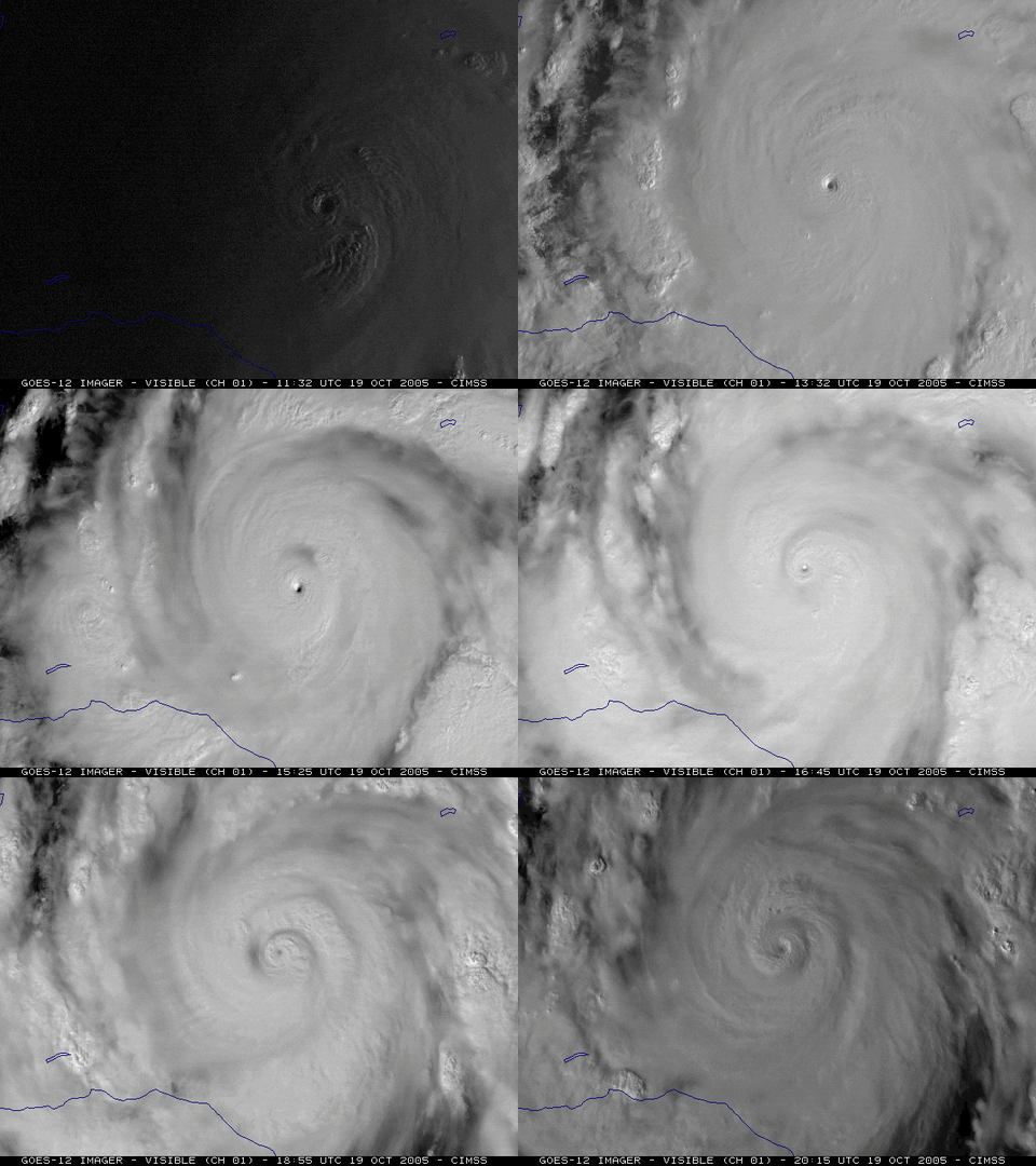
SouthDadeFish wrote:It's quite possible the center is performing some sort of trochoidal oscillation (similar to yesterday) embedded within the larger-scale NW flow. If that's the case, the short-term motion will take on a more eastward and northward component later today. The recent dip to the south would support this theory, however, by no means am I sure this is happening. The longer this westerly motion lasts (say a 3-5 more hours), the more unlikely it is that this is part of a trochoidal oscillation.

Edit: For those wondering what a trochoidal oscillation looks like in a TC, here is a classic example from Hurricane Wilma (2005):

Image

I disagree with this as of current sat images. i saw yesterday 's cyclonic loop which was quite clear it was doing. this is still stair stepping.
1 likes   
Robbielyn McCrary
I know just about enough to sound like I know what I'm talking about sometimes. But for your safety please follow the nhc for truly professional forecasting. :D

User avatar
pgoss11
Category 2
Category 2
Posts: 702
Joined: Tue Sep 02, 2003 3:55 pm

Re: ATL: MATTHEW - Hurricane - Discussion

#3395 Postby pgoss11 » Sun Oct 02, 2016 9:45 am

Lighthousewatch28 wrote:Could the coast of South Carolina feel hurricane effects?


It's too early to tell that for now. Our meteorologist in Charleston said the minimal conditions we would see are breezy rainy conditions with coastal flooding and beach erosion. That's the minimum. If the storm tracks more westward then things could be much worse, but can't say that for now.
1 likes   

User avatar
Evil Jeremy
S2K Supporter
S2K Supporter
Posts: 5463
Age: 32
Joined: Mon Apr 10, 2006 2:10 pm
Location: Los Angeles, CA

Re: ATL: MATTHEW - Hurricane - Discussion

#3396 Postby Evil Jeremy » Sun Oct 02, 2016 9:53 am

HURRICANE CENTER LOCATED NEAR 14.0N 74.6W AT 02/1500Z

PRESENT MOVEMENT TOWARD THE WEST OR 270 DEGREES AT 3 KT

New track shows Matthew hitting 75W tomorrow, followed by a NNE track.

5 day point is NNW of last advisory.
0 likes   
Frances 04 / Jeanne 04 / Katrina 05 / Wilma 05 / Fay 08 / Debby 12 / Andrea 13 / Colin 16 / Hermine 16 / Matthew 16 / Irma 17

jlauderdal
S2K Supporter
S2K Supporter
Posts: 7210
Joined: Wed May 19, 2004 5:46 am
Location: NE Fort Lauderdale
Contact:

Re: ATL: MATTHEW - Hurricane - Discussion

#3397 Postby jlauderdal » Sun Oct 02, 2016 9:55 am

Evil Jeremy wrote:HURRICANE CENTER LOCATED NEAR 14.0N 74.6W AT 02/1500Z

PRESENT MOVEMENT TOWARD THE WEST OR 270 DEGREES AT 3 KT

New track shows Matthew hitting 75W tomorrow, followed by a NNE track.

5 day point is NNW of last advisory.


west at 3 knots isnt going to send it racing to jamiaca..thats for sure
0 likes   

tolakram
Admin
Admin
Posts: 20036
Age: 62
Joined: Sun Aug 27, 2006 8:23 pm
Location: Florence, KY (name is Mark)

Re: ATL: MATTHEW - Hurricane - Discussion

#3398 Postby tolakram » Sun Oct 02, 2016 9:57 am

Hurricane sector visible, since it refuses to move north into the better loop. :x

I think the best directional descriptor is 'near stationary'

http://weather.msfc.nasa.gov/cgi-bin/get-goes?satellite=GOES-E%20HURRICANE&lat=14&lon=-75&info=vis&zoom=1&width=1024&height=768&type=Animation&quality=92&palette=ir1.pal&numframes=7&mapcolor=gray&map=county
0 likes   
M a r k
- - - - -
Join us in chat: Storm2K Chatroom Invite. Android and IOS apps also available.

The posts in this forum are NOT official forecasts and should not be used as such. Posts are NOT endorsed by any professional institution or STORM2K.org. For official information and forecasts, please refer to NHC and NWS products.

User avatar
Nimbus
Category 5
Category 5
Posts: 5351
Joined: Mon Jul 19, 2004 10:54 am

Re: ATL: MATTHEW - Hurricane - Discussion

#3399 Postby Nimbus » Sun Oct 02, 2016 9:58 am

The diversity in the model tracks is due to an intentional compartmentalization.
Very similar to the static Bam suite models that breakout current steering by layer.
Very similar to how very good chess players practice different opening and middle games by using different chess programs.

One thing that probably needs saying is that if the probability of a fine line track is about equal over a wider swath, it may make sense to run the track closer to populated areas that will soon be affected. Preparation and evacuation forethought should be part of everyone's end game.
0 likes   

User avatar
toad strangler
S2K Supporter
S2K Supporter
Posts: 4545
Joined: Sun Jul 28, 2013 3:09 pm
Location: Earth
Contact:

Re: ATL: MATTHEW - Hurricane - Discussion

#3400 Postby toad strangler » Sun Oct 02, 2016 9:58 am

yeah 3mph is just inching along. Nearly STAT.I suspect that a real N component slides in here pretty soon along with an increase in overall speed.
0 likes   


Return to “2016”

Who is online

Users browsing this forum: No registered users and 10 guests