
ATL: JULIA - Post-Tropical - Discussion
Moderator: S2k Moderators
-
tolakram
- Admin

- Posts: 20186
- Age: 62
- Joined: Sun Aug 27, 2006 8:23 pm
- Location: Florence, KY (name is Mark)
Re: ATL: JULIA - Tropical Storm - Discussion
saved wundermap of local obs
0 likes
M a r k
- - - - -
Join us in chat: Storm2K Chatroom Invite. Android and IOS apps also available.
The posts in this forum are NOT official forecasts and should not be used as such. Posts are NOT endorsed by any professional institution or STORM2K.org. For official information and forecasts, please refer to NHC and NWS products.
-
northjaxpro

- S2K Supporter

- Posts: 8900
- Joined: Mon Sep 27, 2010 11:21 am
- Location: Jacksonville, FL
Re: ATL: JULIA - Tropical Storm - Discussion
LarryWx wrote:SeGaBob wrote::uarrow: I think coastal Ga will miss out also unless a big unforseen shift west happens. It's pretty obvious now. Glad your power is back on.
Yeah, there has been little rainfall overnight in SAV from this. She does seem to be moving east of the model consensus and actually went NNE over the last few hours. Perhaps, the convection over water is causing her to move east of the models? If this continues, we may get little additional rainfall from her. Let's see what happens.
I really believe that the abnormally warm effects of the Gulf Stream really played a significant factor with the development of Julia. Strong convection over the Gulf Stream and near the coast pulled the development of the LLC closer to the coast, and put it moving N-N-NE since yesterday. The thinking by NHC was that the vorticity eas going to move N-NW as it.initially moved inland in Brevard County. But, my personal opinion, I feel that Julia actually developed into a full fledged tropical cyclone as she approached late yesterday afternoon near the Palm Coast area, which is just south of St. Augustine.
Julia will be a very interesting post season analysis in my opinion, besides the fact that it formed over land in Northeast Florida.
But. no doubt that the abnormally warm ssts of the Gulf Stream has definitely shown its impacts close to home this season. Also, this definitely played a factor with Hermine and the unnamed system in August that brought the massive flooding to Louisiana.
0 likes
NEVER, EVER SAY NEVER in the tropics and weather in general, and most importantly, with life itself!!
________________________________________________________________________________________
Fay 2008 Beryl 2012 Debby 2012 Colin 2016 Hermine 2016 Julia 2016 Matthew 2016 Irma 2017 Dorian 2019
________________________________________________________________________________________
Fay 2008 Beryl 2012 Debby 2012 Colin 2016 Hermine 2016 Julia 2016 Matthew 2016 Irma 2017 Dorian 2019


Re: ATL: JULIA - Tropical Storm - Discussion
SeGaBob wrote:Local met showed a map that showed me getting almost 18 inches and said that can't be right. I agree.
This is one of my pet peeves. Showing a map (usually raw model output) to the public during a broadcast that would have devastating implications and then saying it cant be right. If you don't think it is right, maybe its better not to broadcast it.
1 likes

Re: ATL: JULIA - Tropical Storm - Discussion
Looks like partial decoupling in the early visibles. It's not so much that any rotations are splitting off, but it looks like some of the energy is getting elongated SW which is usually indicative of a splitting system. Just has an odder appearance than you'd expect without two distinct rotations. I just thought it was notable.
http://www.ssd.noaa.gov/PS/TROP/floater ... imated.gif
http://www.ssd.noaa.gov/PS/TROP/floater ... imated.gif
0 likes
-
wxman57

- Moderator-Pro Met

- Posts: 23175
- Age: 68
- Joined: Sat Jun 21, 2003 8:06 pm
- Location: Houston, TX (southwest)
Re: ATL: JULIA - Tropical Storm - Discussion
Center is on the coast just NNE of Brunswick, GA. Looks weaker than yesterday. Buoy off mid GA coast went through the heavier squalls earlier with sub-30kt winds. Winds all along the GA coast well under 20 kts, generally under 10-15 kts. I suppose it could generate a tiny area of TS winds in some of the squalls offshore, but wind isn't the main threat. Wouldn't be surprised if some parts of coastal SC & GA get over a foot.
2 likes
-
cycloneye

- Admin
- Posts: 149550
- Age: 69
- Joined: Thu Oct 10, 2002 10:54 am
- Location: San Juan, Puerto Rico
Re: ATL: JULIA - Advisories
TROPICAL STORM JULIA DISCUSSION NUMBER 3
NWS NATIONAL HURRICANE CENTER MIAMI FL AL112016
1100 AM EDT WED SEP 14 2016
Julia is estimated to be maintaining 35-kt winds, based on WSR 88-D
Doppler velocity data, well offshore of the coast. Since the
system will continue to interact with land, weakening is forecast
and the cyclone is expected to become a remnant low in a couple of
days. The official intensity forecast is close to the latest
D-SHIPS and LGEM guidance. There is a possibility, however, that
the system could strengthen if it moves far enough out over water.
The center of Julia may be reforming closer to the Georgia coast,
although the surface observations are not yet definitive, and the
initial motion is a highly uncertain 030/5 kt. The tropical
cyclone is likely to remain in weak steering currents near the axis
of the subtropical ridge, and the track guidance models indicate
that some erratic motion is likely over the next couple of days.
The official forecast shows a very slow motion after 12 hours, and
is east of the previous NHC track.
The slow forward speed of Julia is expected to result in locally
heavy rainfall of 3 to 6 inches, with isolated maximum amounts near
10 inches along portions of the South Carolina coastline. These
rains could result in flash flooding.
FORECAST POSITIONS AND MAX WINDS
INIT 14/1500Z 31.4N 81.3W 35 KT 40 MPH...INLAND
12H 15/0000Z 32.0N 81.0W 35 KT 40 MPH...INLAND
24H 15/1200Z 32.2N 80.8W 30 KT 35 MPH...INLAND
36H 16/0000Z 32.3N 80.7W 25 KT 30 MPH...INLAND
48H 16/1200Z 32.3N 80.6W 20 KT 25 MPH...POST-TROP/REMNT LOW
72H 17/1200Z...DISSIPATED
$$
Forecaster Pasch
0 likes
Visit the Caribbean-Central America Weather Thread where you can find at first post web cams,radars
and observations from Caribbean basin members Click Here
and observations from Caribbean basin members Click Here


Re: ATL: JULIA - Tropical Storm - Discussion
Steve wrote:Looks like partial decoupling in the early visibles. It's not so much that any rotations are splitting off, but it looks like some of the energy is getting elongated SW which is usually indicative of a splitting system. Just has an odder appearance than you'd expect without two distinct rotations. I just thought it was notable.
http://www.ssd.noaa.gov/PS/TROP/floater ... imated.gif
Yeah, looks like it peaked yesterday but still, what a storm.
1 likes
The posts or stuff said are NOT an official forecast. Please look to the NHC and NWS for official forecasts and products.
Floyd-1999, Frances-2004, Jeanne-2004, Fay-2008, Beryl-2012, Debby-2012, Colin-2016, Hermine-2016, Julia-2016, Matthew-2016, Irma-2017, Elsa-2021, Idalia-2023, Debby-2024, Helene-2024.
Go Gators! Go Jags!
Floyd-1999, Frances-2004, Jeanne-2004, Fay-2008, Beryl-2012, Debby-2012, Colin-2016, Hermine-2016, Julia-2016, Matthew-2016, Irma-2017, Elsa-2021, Idalia-2023, Debby-2024, Helene-2024.
Go Gators! Go Jags!
-
Emmett_Brown

- Category 5

- Posts: 1433
- Joined: Wed Aug 24, 2005 9:10 pm
- Location: Sarasota FL
Re: ATL: JULIA - Tropical Storm - Discussion
12Z GFS through 78 hours barely moves Julia. Drifts east just off shore, then back to the SW to park the remnant low over Jax. Slowly weakens it through the period.
1 likes

Re: ATL: JULIA - Tropical Storm - Discussion
Based on the surface obs...I would say she is now offshore or the center has elongated SW to NE toward the convection...
0 likes
-
wxman57
- Moderator-Pro Met
- Posts: 23175
- Age: 68
- Joined: Sat Jun 21, 2003 8:06 pm
- Location: Houston, TX (southwest)
Re: ATL: JULIA - Tropical Storm - Discussion
Buoy offshore Savannah now has WSW wind at 20, indicting the center is offshore SE or E of Savannah. I really don't want to have to deal with another stalled coastal storm for days and days (and days).
0 likes
-
'CaneFreak

- Category 5
- Posts: 1487
- Joined: Mon Jun 05, 2006 10:50 am
- Location: New Bern, NC
Re: ATL: JULIA - Tropical Storm - Discussion
You and me both. We are issuing 6 hourly products on this at work. Yuck. Die already 
wxman57 wrote:Buoy offshore Savannah now has WSW wind at 20, indicting the center is offshore SE or E of Savannah. I really don't want to have to deal with another stalled coastal storm for days and days (and days).
0 likes
Re: ATL: JULIA - Tropical Storm - Discussion
wxman57 wrote:Buoy offshore Savannah now has WSW wind at 20, indicting the center is offshore SE or E of Savannah. I really don't want to have to deal with another stalled coastal storm for days and days (and days).
We saw the same thing...I would not want the CMC track...days to track...
0 likes
-
northjaxpro
- S2K Supporter
- Posts: 8900
- Joined: Mon Sep 27, 2010 11:21 am
- Location: Jacksonville, FL
Re: ATL: JULIA - Tropical Storm - Discussion
Yeah unfortunately the GFS forecast just may happen and GFS may be right . Steering currents are forecast to be really weak the next few days.I saw the run earlier this morning and Julia could meander around, stall out tor come right back again over Northeast Florida and Southeast Georgia as a remnant Low in a few days per GFS that would lead to more rain for our area if that scenario plays out, but we'll just watch it
0 likes
NEVER, EVER SAY NEVER in the tropics and weather in general, and most importantly, with life itself!!
________________________________________________________________________________________
Fay 2008 Beryl 2012 Debby 2012 Colin 2016 Hermine 2016 Julia 2016 Matthew 2016 Irma 2017 Dorian 2019
________________________________________________________________________________________
Fay 2008 Beryl 2012 Debby 2012 Colin 2016 Hermine 2016 Julia 2016 Matthew 2016 Irma 2017 Dorian 2019

Re: ATL: JULIA - Tropical Storm - Discussion
drezee wrote:wxman57 wrote:Buoy offshore Savannah now has WSW wind at 20, indicting the center is offshore SE or E of Savannah. I really don't want to have to deal with another stalled coastal storm for days and days (and days).
We saw the same thing...I would not want the CMC track...days to track...
Some children like Julia just never wanna venture far from home - "Florida raised and Georgia hazed"
1 likes
Andy D
(For official information, please refer to the NHC and NWS products.)
(For official information, please refer to the NHC and NWS products.)
-
JtSmarts

- S2K Supporter
- Posts: 1442
- Age: 40
- Joined: Thu Jul 10, 2003 1:29 pm
- Location: Columbia, South Carolina
Re: ATL: JULIA - Tropical Storm - Discussion
wxman57 wrote:Buoy offshore Savannah now has WSW wind at 20, indicting the center is offshore SE or E of Savannah. I really don't want to have to deal with another stalled coastal storm for days and days (and days).
Were you ever able to get an off day? I feel like you conjured up Ian, Julia and 12 lol.
0 likes

Re: ATL: JULIA - Tropical Storm - Discussion
Julia must be redheaded, it has been reluctant to move inland, has followed the coastline all the way from central FL, wow! These weak storms are fun to track.
0 likes
-
northjaxpro
- S2K Supporter
- Posts: 8900
- Joined: Mon Sep 27, 2010 11:21 am
- Location: Jacksonville, FL
Re: ATL: JULIA - Tropical Storm - Discussion
You can still see the shear effects on Julia as the center of circulation is becoming exposed as convection is removed east of the COC currently. The visible imagery really shows the COC really good, which iis right at the mouth of the Savannah River currently. also, a very wierd configuaration with thant elonagted look from NE to SW n visible imagery.
Also, the N/NE movement is already slowing to a crawl . Lots of rain potential for the SC Low Country, provided if Julia stays and meanders closer to the coast.

Also, the N/NE movement is already slowing to a crawl . Lots of rain potential for the SC Low Country, provided if Julia stays and meanders closer to the coast.
0 likes
NEVER, EVER SAY NEVER in the tropics and weather in general, and most importantly, with life itself!!
________________________________________________________________________________________
Fay 2008 Beryl 2012 Debby 2012 Colin 2016 Hermine 2016 Julia 2016 Matthew 2016 Irma 2017 Dorian 2019
________________________________________________________________________________________
Fay 2008 Beryl 2012 Debby 2012 Colin 2016 Hermine 2016 Julia 2016 Matthew 2016 Irma 2017 Dorian 2019
Re: ATL: JULIA - Tropical Storm - Discussion
We've been getting steady rain here for the last 2 hours or so, but mainly only light to occasionally moderate.
Maybe she will hang around as the consensus says but the storm has been drifting east of all projections since yesterday. So, I wonder if she will end up drifting around aimlessly but further offshore than the model consensus.
Any opinions on this?
Maybe she will hang around as the consensus says but the storm has been drifting east of all projections since yesterday. So, I wonder if she will end up drifting around aimlessly but further offshore than the model consensus.
Any opinions on this?
0 likes
Personal Forecast Disclaimer:
The posts in this forum are NOT official forecasts and should not be used as such. They are just the opinion of the poster and may or may not be backed by sound meteorological data. They are NOT endorsed by any professional institution or storm2k.org. For official information, please refer to the NHC and NWS products.
The posts in this forum are NOT official forecasts and should not be used as such. They are just the opinion of the poster and may or may not be backed by sound meteorological data. They are NOT endorsed by any professional institution or storm2k.org. For official information, please refer to the NHC and NWS products.
Re: ATL: JULIA - Tropical Storm - Discussion
It does appear the LLC has moved offshore now, with a C-MAN station along the coast just east of Savannah reporting NNE winds, gusting to 45 mph.
Saved radar loop:
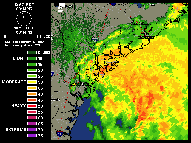
Saved radar loop:
Last edited by NDG on Wed Sep 14, 2016 12:26 pm, edited 1 time in total.
0 likes
-
northjaxpro
- S2K Supporter
- Posts: 8900
- Joined: Mon Sep 27, 2010 11:21 am
- Location: Jacksonville, FL
Re: ATL: JULIA - Tropical Storm - Discussion
Yes, Julia's circulation center is just off shore now in the proximity of the mouth of the Savannah River NDG.
1 likes
NEVER, EVER SAY NEVER in the tropics and weather in general, and most importantly, with life itself!!
________________________________________________________________________________________
Fay 2008 Beryl 2012 Debby 2012 Colin 2016 Hermine 2016 Julia 2016 Matthew 2016 Irma 2017 Dorian 2019
________________________________________________________________________________________
Fay 2008 Beryl 2012 Debby 2012 Colin 2016 Hermine 2016 Julia 2016 Matthew 2016 Irma 2017 Dorian 2019
Who is online
Users browsing this forum: No registered users and 15 guests