ATL: JULIA - Post-Tropical - Discussion

Moderator: S2k Moderators

Message
Author
Aric Dunn
Category 5
Category 5
Posts: 21238
Age: 42
Joined: Sun Sep 19, 2004 9:58 pm
Location: Ready for the Chase.
Contact:

Re: ATL; INVEST 93L - Discussion - 8 PM TWO up to 70%-70% - Advisories likely at 11 PM EDT

#421 Postby Aric Dunn » Tue Sep 13, 2016 7:43 pm

SeGaBob wrote:This might not even make it into Georgia the way it looks now. Moving more North than NNW.


not only that if the convection associated with the MLC offshore at some point its completely possible for the center migrate or reform offshore at anytime.
0 likes   
Note: If I make a post that is brief. Please refer back to previous posts for the analysis or reasoning. I do not re-write/qoute what my initial post said each time.
If there is nothing before... then just ask :)

Space & Atmospheric Physicist, Embry-Riddle Aeronautical University,
I believe the sky is falling...

User avatar
JaxGator
Category 2
Category 2
Posts: 780
Joined: Sun Jun 12, 2016 3:33 pm
Location: Jacksonville Florida

Re: ATL; INVEST 93L - Discussion - 8 PM TWO up to 70%-70% - Advisories likely at 11 PM EDT

#422 Postby JaxGator » Tue Sep 13, 2016 7:50 pm

Been getting a NE wind with the latest squall but the winds are around 10-15 mph with gusts up to 20.
0 likes   
The posts or stuff said are NOT an official forecast. Please look to the NHC and NWS for official forecasts and products.

Floyd-1999, Frances-2004, Jeanne-2004, Fay-2008, Beryl-2012, Debby-2012, Colin-2016, Hermine-2016, Julia-2016, Matthew-2016, Irma-2017, Elsa-2021, Idalia-2023, Debby-2024, Helene-2024.


Go Gators! Go Jags!

SeGaBob

Re: ATL; INVEST 93L - Discussion - 8 PM TWO up to 70%-70% - Advisories likely at 11 PM EDT

#423 Postby SeGaBob » Tue Sep 13, 2016 7:58 pm

Winds at 35 kts according to this...was 30 kts earlier.

http://www.tropicaltidbits.com/storminfo/
Last edited by SeGaBob on Tue Sep 13, 2016 8:06 pm, edited 1 time in total.
0 likes   

User avatar
Joe Snow
Tropical Depression
Tropical Depression
Posts: 55
Age: 62
Joined: Fri Aug 19, 2016 12:02 am

Re: ATL; INVEST 93L - Discussion - 8 PM TWO up to 70%-70% - Advisories likely at 11 PM EDT

#424 Postby Joe Snow » Tue Sep 13, 2016 7:59 pm

Looks like sustained winds near "Penney Farms" Florida are 40+ KNTS, St. Augustine 4"-6" flooding and Augustine Airport reported a gust of 45 MPH, outer bands look like they are building.
0 likes   

User avatar
NDG
S2K Supporter
S2K Supporter
Posts: 15446
Joined: Sun Jul 09, 2006 10:14 pm
Location: Orlando, FL

Re: ATL; INVEST 93L - Discussion

#425 Postby NDG » Tue Sep 13, 2016 8:04 pm

0 likes   

User avatar
Fishing
S2K Supporter
S2K Supporter
Posts: 67
Age: 65
Joined: Thu Sep 03, 2015 11:53 am
Location: Mount Pleasant, SC

Re: ATL; INVEST 93L - Discussion

#426 Postby Fishing » Tue Sep 13, 2016 8:10 pm

Not sure what this means:
 https://twitter.com/wxgarrett/status/775861228774256641


Garrett Bedenbaugh/Jacksonville Tweet.
0 likes   

Aric Dunn
Category 5
Category 5
Posts: 21238
Age: 42
Joined: Sun Sep 19, 2004 9:58 pm
Location: Ready for the Chase.
Contact:

Re: ATL; INVEST 93L - Discussion

#427 Postby Aric Dunn » Tue Sep 13, 2016 8:11 pm

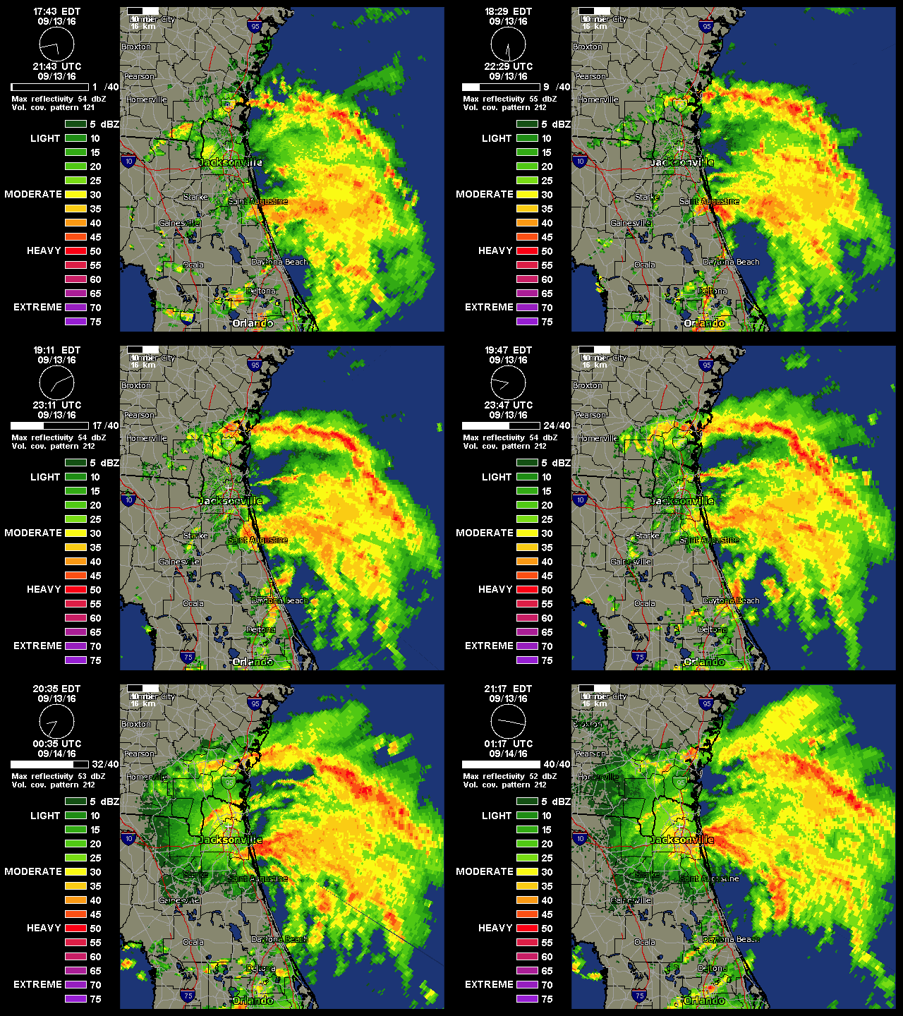
radar showing a slight NNE motion the last hour. hmmm..
0 likes   
Note: If I make a post that is brief. Please refer back to previous posts for the analysis or reasoning. I do not re-write/qoute what my initial post said each time.
If there is nothing before... then just ask :)

Space & Atmospheric Physicist, Embry-Riddle Aeronautical University,
I believe the sky is falling...

User avatar
Hammy
Category 5
Category 5
Posts: 5849
Age: 41
Joined: Fri May 25, 2012 5:25 pm
Contact:

Re: ATL; INVEST 93L - Discussion - 8 PM TWO up to 70%-70% - Advisories likely at 11 PM EDT

#428 Postby Hammy » Tue Sep 13, 2016 8:12 pm

TropicalAnalystwx13 wrote: NHC revised the Best Track to push designation back to 6z this morning, which is much more reasonable.


So is this officially in the database as a tropical storm at this point?
0 likes   
The above post is not official and should not be used as such. It is the opinion of the poster and may or may not be backed by sound meteorological data. It is not endorsed by any professional institution or storm2k.org. For official information, please refer to the NHC and NWS products.

User avatar
northjaxpro
S2K Supporter
S2K Supporter
Posts: 8900
Joined: Mon Sep 27, 2010 11:21 am
Location: Jacksonville, FL

Re: ATL; INVEST 93L - Discussion

#429 Postby northjaxpro » Tue Sep 13, 2016 8:14 pm

Just gott a wind gusts to 38 miles hour and a heavy Squad and few minutes ago it is a rough squally windy night here at the old Ponderosa. This is definitely a tropical depression and with these gusts that I'm getting any squash here we're getting there a tropical storm situation right now. akai received over 2.5 inches since 7:30 p.m. The LLC is just south of my locale currently.
Last edited by northjaxpro on Tue Sep 13, 2016 8:18 pm, edited 1 time in total.
0 likes   
NEVER, EVER SAY NEVER in the tropics and weather in general, and most importantly, with life itself!!

________________________________________________________________________________________

Fay 2008 Beryl 2012 Debby 2012 Colin 2016 Hermine 2016 Julia 2016 Matthew 2016 Irma 2017 Dorian 2019

Aric Dunn
Category 5
Category 5
Posts: 21238
Age: 42
Joined: Sun Sep 19, 2004 9:58 pm
Location: Ready for the Chase.
Contact:

Re: ATL; INVEST 93L - Discussion

#430 Postby Aric Dunn » Tue Sep 13, 2016 8:14 pm

according to models it should start to slow down quite a bit. if that slow down is close to the coast or offshore it should maintain...
0 likes   
Note: If I make a post that is brief. Please refer back to previous posts for the analysis or reasoning. I do not re-write/qoute what my initial post said each time.
If there is nothing before... then just ask :)

Space & Atmospheric Physicist, Embry-Riddle Aeronautical University,
I believe the sky is falling...

User avatar
stormhunter7
Category 2
Category 2
Posts: 762
Joined: Mon May 26, 2008 3:13 pm
Location: Panama City Beach, Florida
Contact:

Re: ATL; INVEST 93L - Discussion

#431 Postby stormhunter7 » Tue Sep 13, 2016 8:15 pm

Fishing wrote:Not sure what this means:
 https://twitter.com/wxgarrett/status/775861228774256641


Garrett Bedenbaugh/Jacksonville Tweet.


He doesn't understand the wx computer system. Icon is set based on a criteria such as winds. In this case the 00z data starts at TS, so the graphic changed when it received the new 00z data. NHC will make the call on calling it a system. I believe there are just waiting on some sustained winds of 35mph on some weather sensors along the coast. Shouldn't be long.
Last edited by stormhunter7 on Tue Sep 13, 2016 8:35 pm, edited 1 time in total.
1 likes   
The following post is NOT an official forecast and should not be used as such. It is just the opinion of the poster and may or may not be backed by sound meteorological data. It is NOT endorsed by any professional institution including storm2k.org For Official Information please refer to the NHC and NWS products. http://www.nhc.noaa.gov

jdjaguar
Category 2
Category 2
Posts: 551
Joined: Fri Aug 26, 2005 12:07 pm
Location: Jacksonville Beach, FL

Re: ATL; INVEST 93L - Discussion

#432 Postby jdjaguar » Tue Sep 13, 2016 8:20 pm

stormhunter7 wrote:
Fishing wrote:Not sure what this means:
 https://twitter.com/wxgarrett/status/775861228774256641


Garrett Bedenbaugh/Jacksonville Tweet.


He doesn't understand the system. Icon is set based on a criteria such as winds. In this case the 00z data starts at TS, so the graphic changed when it received the new 00z data. NHC will make the call on calling it a system. I believe there are just waiting on some sustained winds of 35mph on some weather sensors along the coast. Shouldn't be long.


Garrett is the
Certified Broadcast Meteorologist (#636) at @ActionNewsJax (FOX/CBS affiliate),
pretty sure he understands the system
1 likes   

CrazyC83
Professional-Met
Professional-Met
Posts: 34002
Joined: Tue Mar 07, 2006 11:57 pm
Location: Deep South, for the first time!

Re: ATL; INVEST 93L - Discussion - 8 PM TWO up to 70%-70% - Advisories likely at 11 PM EDT

#433 Postby CrazyC83 » Tue Sep 13, 2016 8:21 pm

Joe Snow wrote:Looks like sustained winds near "Penney Farms" Florida are 40+ KNTS, St. Augustine 4"-6" flooding and Augustine Airport reported a gust of 45 MPH, outer bands look like they are building.


Given timing periods and spacial extent, that would support a 45 kt intensity.
0 likes   

User avatar
NDG
S2K Supporter
S2K Supporter
Posts: 15446
Joined: Sun Jul 09, 2006 10:14 pm
Location: Orlando, FL

Re: ATL; INVEST 93L - Discussion

#434 Postby NDG » Tue Sep 13, 2016 8:23 pm

Image
0 likes   

User avatar
stormhunter7
Category 2
Category 2
Posts: 762
Joined: Mon May 26, 2008 3:13 pm
Location: Panama City Beach, Florida
Contact:

Re: ATL; INVEST 93L - Discussion

#435 Postby stormhunter7 » Tue Sep 13, 2016 8:26 pm

https://www.wunderground.com/history/ai ... story.html

Wind Speed 14 mph ()
Max Wind Speed 29 mph
Max Gust Speed 39 mph
0 likes   
The following post is NOT an official forecast and should not be used as such. It is just the opinion of the poster and may or may not be backed by sound meteorological data. It is NOT endorsed by any professional institution including storm2k.org For Official Information please refer to the NHC and NWS products. http://www.nhc.noaa.gov

fox13weather
Professional-Met
Professional-Met
Posts: 161
Joined: Tue Sep 20, 2005 7:49 pm

Re: ATL; INVEST 93L - Discussion

#436 Postby fox13weather » Tue Sep 13, 2016 8:27 pm

stormhunter7 wrote:
Fishing wrote:Not sure what this means:
 https://twitter.com/wxgarrett/status/775861228774256641


Garrett Bedenbaugh/Jacksonville Tweet.


He doesn't understand the system. Icon is set based on a criteria such as winds. In this case the 00z data starts at TS, so the graphic changed when it received the new 00z data. NHC will make the call on calling it a system. I believe there are just waiting on some sustained winds of 35mph on some weather sensors along the coast. Shouldn't be long.


he understands the system just fine ...WSI graphics system reads data coming in from the NHC ....your explanation makes no sense.
2 likes   

User avatar
centuryv58
Tropical Storm
Tropical Storm
Posts: 233
Age: 67
Joined: Sat Jul 30, 2016 1:24 pm
Location: Southeast Florida

Re: ATL; INVEST 93L - Discussion

#437 Postby centuryv58 » Tue Sep 13, 2016 8:50 pm

93L seems to have out foxed (no FNN pun intended) many of us here on Storm2K.
0 likes   

User avatar
northjaxpro
S2K Supporter
S2K Supporter
Posts: 8900
Joined: Mon Sep 27, 2010 11:21 am
Location: Jacksonville, FL

Re: ATL; INVEST 93L - Discussion

#438 Postby northjaxpro » Tue Sep 13, 2016 9:05 pm

Looking at that radar the center of circulation it's approaching Downtown Jacksonville from the south I just got to wind gust of 42 miles an hour in squalls the highest here at my local so staying with the sustained wind between 25 to 30 miles an hour Heavy Rain squalls continuing was already picked up over 3 inches of rain .

Mayport had wind gust to 48 mph last hour.
2 likes   
NEVER, EVER SAY NEVER in the tropics and weather in general, and most importantly, with life itself!!

________________________________________________________________________________________

Fay 2008 Beryl 2012 Debby 2012 Colin 2016 Hermine 2016 Julia 2016 Matthew 2016 Irma 2017 Dorian 2019

User avatar
JaxGator
Category 2
Category 2
Posts: 780
Joined: Sun Jun 12, 2016 3:33 pm
Location: Jacksonville Florida

Re: ATL; INVEST 93L - Discussion

#439 Postby JaxGator » Tue Sep 13, 2016 9:08 pm

Center is now over Nocatee just south of the Duval-St. Johns county line. Rainbands with possible TS conditions are spreading north into Duval. Vilano Beach got hit by heavy rain and wind earlier and got the brunt of it.
1 likes   
The posts or stuff said are NOT an official forecast. Please look to the NHC and NWS for official forecasts and products.

Floyd-1999, Frances-2004, Jeanne-2004, Fay-2008, Beryl-2012, Debby-2012, Colin-2016, Hermine-2016, Julia-2016, Matthew-2016, Irma-2017, Elsa-2021, Idalia-2023, Debby-2024, Helene-2024.


Go Gators! Go Jags!

User avatar
stormhunter7
Category 2
Category 2
Posts: 762
Joined: Mon May 26, 2008 3:13 pm
Location: Panama City Beach, Florida
Contact:

Re: ATL; INVEST 93L - Discussion

#440 Postby stormhunter7 » Tue Sep 13, 2016 9:10 pm

fox13weather wrote:
stormhunter7 wrote:
Fishing wrote:Not sure what this means:
 https://twitter.com/wxgarrett/status/775861228774256641


Garrett Bedenbaugh/Jacksonville Tweet.


He doesn't understand the system. Icon is set based on a criteria such as winds. In this case the 00z data starts at TS, so the graphic changed when it received the new 00z data. NHC will make the call on calling it a system. I believe there are just waiting on some sustained winds of 35mph on some weather sensors along the coast. Shouldn't be long.


he understands the system just fine ...WSI graphics system reads data coming in from the NHC ....your explanation makes no sense.


As stated in my previous post. He tweeted this not long ago.

 https://twitter.com/wxgarrett/status/775873954720411648


0 likes   
The following post is NOT an official forecast and should not be used as such. It is just the opinion of the poster and may or may not be backed by sound meteorological data. It is NOT endorsed by any professional institution including storm2k.org For Official Information please refer to the NHC and NWS products. http://www.nhc.noaa.gov


Return to “2016”

Who is online

Users browsing this forum: No registered users and 2 guests