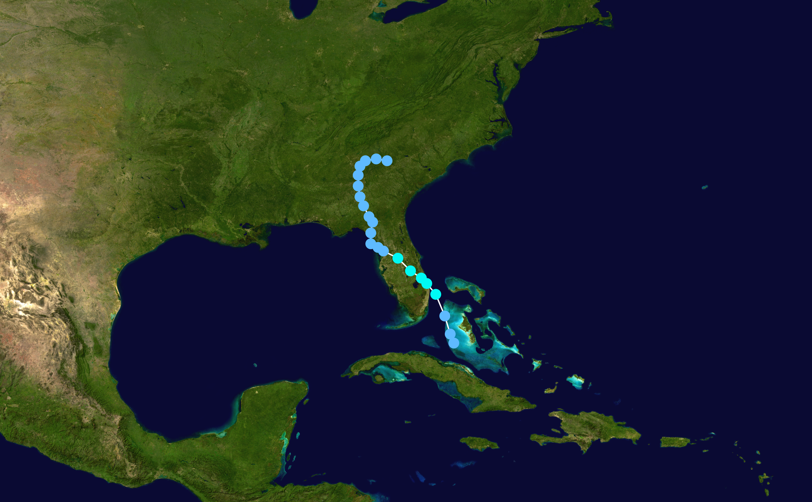
ATL: JULIA - Post-Tropical - Discussion

Moderator: S2k Moderators

Message
Author
User avatar
JaxGator
Category 2
Category 2
Posts: 780
Joined: Sun Jun 12, 2016 3:33 pm
Location: Jacksonville Florida

Re: ATL; INVEST 93L - 2 PM EDT TWO=Up to 40%-40% - Advisories could be initiated this afternoon

#321 Postby JaxGator » Tue Sep 13, 2016 12:35 pm

Fishing wrote:This is the best season (tracking wise) in a very long time ! It seems like forever since we've had such unpredictability.


Tell me about it. This will catch some people off guard but we and the pros are on it. It's closer to Jax than I thought (with TS winds). :eek:
2 likes   
The posts or stuff said are NOT an official forecast. Please look to the NHC and NWS for official forecasts and products.

Floyd-1999, Frances-2004, Jeanne-2004, Fay-2008, Beryl-2012, Debby-2012, Colin-2016, Hermine-2016, Julia-2016, Matthew-2016, Irma-2017, Elsa-2021, Idalia-2023, Debby-2024, Helene-2024.


Go Gators! Go Jags!

Aric Dunn
Category 5
Category 5
Posts: 21238
Age: 42
Joined: Sun Sep 19, 2004 9:58 pm
Location: Ready for the Chase.
Contact:

Re: ATL; INVEST 93L - 2 PM EDT TWO=Up to 40%-40% - Advisories could be initiated this afternoon

#322 Postby Aric Dunn » Tue Sep 13, 2016 12:35 pm

funny its also going to go straight to TS.. lol trends continue with the llc and vorticity clearly moving offshore... 5pm could have a new TS too funny
2 likes   
Note: If I make a post that is brief. Please refer back to previous posts for the analysis or reasoning. I do not re-write/qoute what my initial post said each time.
If there is nothing before... then just ask :)

Space & Atmospheric Physicist, Embry-Riddle Aeronautical University,
I believe the sky is falling...

User avatar
Hammy
Category 5
Category 5
Posts: 5849
Age: 41
Joined: Fri May 25, 2012 5:25 pm
Contact:

Re: ATL; INVEST 93L - 2 PM EDT TWO=Up to 40%-40% - Advisories could be initiated this afternoon

#323 Postby Hammy » Tue Sep 13, 2016 12:36 pm

Aric Dunn wrote:funny its also going to go straight to TS.. lol trends continue with the llc and vorticity clearly moving offshore... 5pm could have a new TS too funny


Somebody mentioned Jerry 1995 as a comparison, funny this would also be J.
0 likes   
The above post is not official and should not be used as such. It is the opinion of the poster and may or may not be backed by sound meteorological data. It is not endorsed by any professional institution or storm2k.org. For official information, please refer to the NHC and NWS products.

Aric Dunn
Category 5
Category 5
Posts: 21238
Age: 42
Joined: Sun Sep 19, 2004 9:58 pm
Location: Ready for the Chase.
Contact:

Re: ATL; INVEST 93L - 2 PM EDT TWO=Up to 40%-40% - Advisories could be initiated this afternoon

#324 Postby Aric Dunn » Tue Sep 13, 2016 12:40 pm

TS Tammy

Image


VS. TS Jerry original forecast for 93L was very similar to track jerry took.. now its more like Tammy. mix between them.

Image
0 likes   
Note: If I make a post that is brief. Please refer back to previous posts for the analysis or reasoning. I do not re-write/qoute what my initial post said each time.
If there is nothing before... then just ask :)

Space & Atmospheric Physicist, Embry-Riddle Aeronautical University,
I believe the sky is falling...

User avatar
Steve
S2K Supporter
S2K Supporter
Posts: 9621
Joined: Sat Apr 05, 2003 11:41 pm
Location: Not a state-caster

Re: ATL; INVEST 93L - 2 PM EDT TWO=Up to 40%-40% - Advisories could be initiated this afternoon

#325 Postby Steve » Tue Sep 13, 2016 12:48 pm

JaxGator wrote:
Fishing wrote:This is the best season (tracking wise) in a very long time ! It seems like forever since we've had such unpredictability.


Tell me about it. This will catch some people off guard but we and the pros are on it. It's closer to Jax than I thought (with TS winds). :eek:


Agreed. It's the subtropics in September. Almost anything is possible, and things happen quickly sometimes. I'm not going to be surprised if ex-92L spins up something over the weekend as well (even if weak and unclassified). It's that time of year, and it doesn't always take much to get a TD or named system going.
0 likes   

OntarioEggplant
Category 1
Category 1
Posts: 312
Joined: Sun Aug 07, 2016 11:16 am

Re: ATL; INVEST 93L - 2 PM EDT TWO=Up to 40%-40% - Advisories could be initiated this afternoon

#326 Postby OntarioEggplant » Tue Sep 13, 2016 12:49 pm

Does anyone else feel like with at least 93L, and one can argue 92L as well, that the NHC is dropping the ball on observations of these invests with respect to recon?
1 likes   

Aric Dunn
Category 5
Category 5
Posts: 21238
Age: 42
Joined: Sun Sep 19, 2004 9:58 pm
Location: Ready for the Chase.
Contact:

Re: ATL; INVEST 93L - 2 PM EDT TWO=Up to 40%-40% - Advisories could be initiated this afternoon

#327 Postby Aric Dunn » Tue Sep 13, 2016 12:52 pm

strong tornado signature in southern brevard county and its growing.
0 likes   
Note: If I make a post that is brief. Please refer back to previous posts for the analysis or reasoning. I do not re-write/qoute what my initial post said each time.
If there is nothing before... then just ask :)

Space & Atmospheric Physicist, Embry-Riddle Aeronautical University,
I believe the sky is falling...

User avatar
gatorcane
S2K Supporter
S2K Supporter
Posts: 23691
Age: 47
Joined: Sun Mar 13, 2005 3:54 pm
Location: Boca Raton, FL

Re: ATL; INVEST 93L - 2 PM EDT TWO=Up to 40%-40% - Advisories could be initiated this afternoon

#328 Postby gatorcane » Tue Sep 13, 2016 12:52 pm

Yet another "homebrew" system this season that had it had more time over water could have been significant. The other one that comes to mind is the Gulf low last month that should have been a hurricane if not a major but it stayed just inland along the northern Gulf coast.
1 likes   

User avatar
NDG
S2K Supporter
S2K Supporter
Posts: 15446
Joined: Sun Jul 09, 2006 10:14 pm
Location: Orlando, FL

Re: ATL; INVEST 93L - 2 PM EDT TWO=Up to 40%-40% - Advisories could be initiated this afternoon

#329 Postby NDG » Tue Sep 13, 2016 12:55 pm

Got to love surprising home development.
Feeder band south of Orlando:
Image
2 likes   

User avatar
Evil Jeremy
S2K Supporter
S2K Supporter
Posts: 5463
Age: 32
Joined: Mon Apr 10, 2006 2:10 pm
Location: Los Angeles, CA

Re: ATL; INVEST 93L - 2 PM EDT TWO=Up to 40%-40% - Advisories could be initiated this afternoon

#330 Postby Evil Jeremy » Tue Sep 13, 2016 12:56 pm

This is hilariously quick escalation. I'm all ears now.
1 likes   
Frances 04 / Jeanne 04 / Katrina 05 / Wilma 05 / Fay 08 / Debby 12 / Andrea 13 / Colin 16 / Hermine 16 / Matthew 16 / Irma 17

User avatar
JaxGator
Category 2
Category 2
Posts: 780
Joined: Sun Jun 12, 2016 3:33 pm
Location: Jacksonville Florida

Re: ATL; INVEST 93L - 2 PM EDT TWO=Up to 40%-40% - Advisories could be initiated this afternoon

#331 Postby JaxGator » Tue Sep 13, 2016 12:56 pm

Aric Dunn wrote:strong tornado signature in southern brevard county and its growing.


Tornado warning just issued.
2 likes   
The posts or stuff said are NOT an official forecast. Please look to the NHC and NWS for official forecasts and products.

Floyd-1999, Frances-2004, Jeanne-2004, Fay-2008, Beryl-2012, Debby-2012, Colin-2016, Hermine-2016, Julia-2016, Matthew-2016, Irma-2017, Elsa-2021, Idalia-2023, Debby-2024, Helene-2024.


Go Gators! Go Jags!

User avatar
Fishing
S2K Supporter
S2K Supporter
Posts: 67
Age: 65
Joined: Thu Sep 03, 2015 11:53 am
Location: Mount Pleasant, SC

Re: ATL; INVEST 93L - 2 PM EDT TWO=Up to 40%-40% - Advisories could be initiated this afternoon

#332 Postby Fishing » Tue Sep 13, 2016 12:59 pm

OntarioEggplant wrote:Does anyone else feel like with at least 93L, and one can argue 92L as well, that the NHC is dropping the ball on observations of these invests with respect to recon?

No not at all.
0 likes   

User avatar
Emmett_Brown
Category 5
Category 5
Posts: 1432
Joined: Wed Aug 24, 2005 9:10 pm
Location: Sarasota FL

Re: ATL; INVEST 93L - Discussion - Advisories could be initiated thia afternoon

#333 Postby Emmett_Brown » Tue Sep 13, 2016 1:05 pm

I think, as many people thought, disturbances are struggling, and moving further westward, getting closer to land areas. When they finally do pop, it's really close to land, after days of struggling... which is a hard thing to predict.
1 likes   

LarryWx
S2K Supporter
S2K Supporter
Posts: 6305
Joined: Sun Sep 07, 2003 2:04 pm
Location: GA

Re: ATL; INVEST 93L - Discussion - Advisories could be initiated thia afternoon

#334 Postby LarryWx » Tue Sep 13, 2016 1:16 pm

Exactly one week ago, abajan got the board's attention when he posted this visible loop at the time it was an impressive low level swirl near 13N, 45W as pouch 32L:

viewtopic.php?f=31&t=118284#p2537273

I really think it may have had a LLC all of the way back to at least then.
1 likes   
Personal Forecast Disclaimer:
The posts in this forum are NOT official forecasts and should not be used as such. They are just the opinion of the poster and may or may not be backed by sound meteorological data. They are NOT endorsed by any professional institution or storm2k.org. For official information, please refer to the NHC and NWS products.

User avatar
Steve
S2K Supporter
S2K Supporter
Posts: 9621
Joined: Sat Apr 05, 2003 11:41 pm
Location: Not a state-caster

Re: ATL; INVEST 93L - Discussion - Advisories could be initiated thia afternoon

#335 Postby Steve » Tue Sep 13, 2016 1:19 pm

Hey segaBob,

Looks like CMC 12Z keeps it around you guys for about 7 days or so and then Ivan's it back south and across Florida into the Gulf. That suggests to me that the weather pattern is too complicated for it to figure out what happens to the low. Eventually ridging will set back up in the SW Atlantic per Super Typhoon Meranti's impacts to China. So if it's around in a week, you could see it sinking back Southward or a piece of it if the top shears off.

Caveat: I'm not buying the Canadian, it's just a model, and Bob had asked if there was a way up and out.
http://www.tropicaltidbits.com/analysis ... 0&ypos=216
0 likes   

User avatar
SeaBrz_FL
S2K Supporter
S2K Supporter
Posts: 472
Age: 69
Joined: Thu Aug 12, 2004 10:47 am
Location: Cape Canaveral, FL

Re: ATL; INVEST 93L - Discussion - Advisories could be initiated thia afternoon

#336 Postby SeaBrz_FL » Tue Sep 13, 2016 1:20 pm

Raining like hell here all day in Cape Canaveral, but winds have really picked up over past 90 minutes.

Per Tom Terry (WFTV) minutes ago -- publicly confirmed tornado reported in Barefoot Bay, 40% chance of low developing to TS, 55 mph winds recorded east of Daytona.
2 likes   
Donna/WPB 1960 - terrorized for life :-). Fourth of six generations living on the FL East Coast since the 50's.

User avatar
JaxGator
Category 2
Category 2
Posts: 780
Joined: Sun Jun 12, 2016 3:33 pm
Location: Jacksonville Florida

Re: ATL; INVEST 93L - Discussion - Advisories could be initiated thia afternoon

#337 Postby JaxGator » Tue Sep 13, 2016 1:25 pm

The wind has picked up a little bit from 2 hours ago when it was almost still. Also the pressure is now 1014mb and falling. A 4 mb drop.
0 likes   
The posts or stuff said are NOT an official forecast. Please look to the NHC and NWS for official forecasts and products.

Floyd-1999, Frances-2004, Jeanne-2004, Fay-2008, Beryl-2012, Debby-2012, Colin-2016, Hermine-2016, Julia-2016, Matthew-2016, Irma-2017, Elsa-2021, Idalia-2023, Debby-2024, Helene-2024.


Go Gators! Go Jags!

User avatar
wxman57
Moderator-Pro Met
Moderator-Pro Met
Posts: 22978
Age: 67
Joined: Sat Jun 21, 2003 8:06 pm
Location: Houston, TX (southwest)

Re: ATL; INVEST 93L - Discussion - Advisories could be initiated thia afternoon

#338 Postby wxman57 » Tue Sep 13, 2016 1:30 pm

I'm not seeing where any 34kt winds were reported by a coastal buoy. I see the buoy east of the cape reported 25 kts max. Where is the evidence of TS winds? Radar won't count, as unless the radar is at Daytona Beach it's looking well above the surface (2000-7000ft at 50nm from Melbourne Radar).
0 likes   

LarryWx
S2K Supporter
S2K Supporter
Posts: 6305
Joined: Sun Sep 07, 2003 2:04 pm
Location: GA

Re: ATL; INVEST 93L - Discussion - Advisories could be initiated thia afternoon

#339 Postby LarryWx » Tue Sep 13, 2016 1:31 pm

Very heavy thunderstorm has just come off the ocean here in SAV from a band of showers and tstorms.
1 likes   
Personal Forecast Disclaimer:
The posts in this forum are NOT official forecasts and should not be used as such. They are just the opinion of the poster and may or may not be backed by sound meteorological data. They are NOT endorsed by any professional institution or storm2k.org. For official information, please refer to the NHC and NWS products.

User avatar
JaxGator
Category 2
Category 2
Posts: 780
Joined: Sun Jun 12, 2016 3:33 pm
Location: Jacksonville Florida

Re: ATL; INVEST 93L - Discussion - Advisories could be initiated thia afternoon

#340 Postby JaxGator » Tue Sep 13, 2016 1:36 pm

wxman57 wrote:I'm not seeing where any 34kt winds were reported by a coastal buoy. I see the buoy east of the cape reported 25 kts max. Where is the evidence of TS winds? Radar won't count, as unless the radar is at Daytona Beach it's looking well above the surface (2000-7000ft at 50nm from Melbourne Radar).


Well, the NHC says there's TS winds in the convection off shore but if it's not a TS, then TD most likely.
Last edited by JaxGator on Tue Sep 13, 2016 1:36 pm, edited 1 time in total.
0 likes   
The posts or stuff said are NOT an official forecast. Please look to the NHC and NWS for official forecasts and products.

Floyd-1999, Frances-2004, Jeanne-2004, Fay-2008, Beryl-2012, Debby-2012, Colin-2016, Hermine-2016, Julia-2016, Matthew-2016, Irma-2017, Elsa-2021, Idalia-2023, Debby-2024, Helene-2024.


Go Gators! Go Jags!


Return to “2016”

Who is online

Users browsing this forum: No registered users and 6 guests