ATL: HERMINE - Models
Moderator: S2k Moderators
-
SunnyThoughts
- Category 5

- Posts: 2263
- Joined: Wed Jul 09, 2003 12:42 pm
- Location: Pensacola, Florida
Re: ATL: NINE - Models
GFS at hour 60 finally making a northward turn Not very strong http://www.tropicaltidbits.com/analysis ... 0&ypos=205
0 likes
-
OntarioEggplant
- Category 1

- Posts: 312
- Joined: Sun Aug 07, 2016 11:16 am
Re: ATL: NINE - Models
We probably won't see any improvement in the models until this recon data can be input for the 00Z runs
1 likes
-
gatorcane

- S2K Supporter

- Posts: 23708
- Age: 48
- Joined: Sun Mar 13, 2005 3:54 pm
- Location: Boca Raton, FL
Re: ATL: NINE - Models
GFS with landfall around Cedar Key at 102 hours as an intensifying cyclone
2 likes

-
SunnyThoughts
- Category 5
- Posts: 2263
- Joined: Wed Jul 09, 2003 12:42 pm
- Location: Pensacola, Florida
Re: ATL: NINE - Models
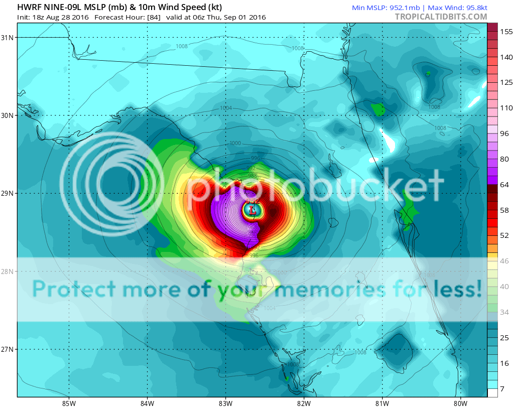
18z HWRF out to hour 12 http://www.tropicaltidbits.com/analysis ... s=0&ypos=0
1 likes
-
chris_fit

- Category 5
- Posts: 3261
- Age: 43
- Joined: Wed Sep 10, 2003 11:58 pm
- Location: Tampa Bay Area, FL
ATL: NINE - Tropical Depression - Discussion
Check out the new HWRF that is coming is rather ominous for Tampa - I pray it does not verify. So far heading straight towards Tampa.

Last edited by chris_fit on Sun Aug 28, 2016 6:15 pm, edited 1 time in total.
1 likes
-
drewschmaltz
- S2K Supporter
- Posts: 351
- Joined: Thu Aug 27, 2015 8:19 pm
Re: ATL: NINE - Models
HWRF = parental discretion advised.
2 likes
I HAVE ABSOLUTELY NO IDEA WHAT I'M TALKING ABOUT. PLEASE CONSULT SOMEONE WHO DOES. START WITH THE NHC. ALL POSTS ARE FOR ENTERTAINMENT PURPOSES ONLY.

-
GeneratorPower

- S2K Supporter
- Posts: 1648
- Age: 46
- Joined: Sun Dec 18, 2005 11:48 pm
- Location: Huntsville, AL
-
HurricaneBelle

- S2K Supporter
- Posts: 1209
- Joined: Sun Aug 27, 2006 6:12 pm
- Location: Clearwater, FL
-
floridasun78
- Category 5
- Posts: 3755
- Joined: Sun May 17, 2009 10:16 pm
- Location: miami fl
Re: ATL: NINE - Models
that was showing south fl look what happen let wait show by wed i hope Tampa people NOT going cazy to store getting hurr supply or media putting hurr flag on their cast
2 likes
Re: ATL: NINE - Models
18z GFDL:
Starts out by diving the system well southwest:
Then it crosses 88W (almost to 89W), then hooks NE
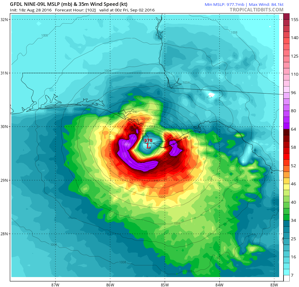
Starts out by diving the system well southwest:
Then it crosses 88W (almost to 89W), then hooks NE
1 likes


Re: ATL: INVEST 99L - Models
bamajammer4eva wrote:Tallahassee NWS model discussionAt first, it seemed like today's 12z guidance was coming into
pretty good agreement with the area of disturbed weather in the
southeast Gulf. Tracks on the 12z GFS, Canadian, and UKMET were
somewhere in between Destin and Cedar Key. Intensities still
varied quite a bit, but each of those three models showed a well
defined system. Then the 12z ECMWF came in and flipped-flopped
tremendously again, now barely showing any system at all. The
ECMWF's performance with this system has been very inconsistent,
which is atypical of this model. Its performance was also poor for
the last heavy rainfall event locally. Perhaps its upgrade to 9
km resolution is causing problems with the convective
parameterization in the model, although that's just a speculation.
At any rate, the official forecast trended towards a wetter
scenario with the potential for the area of disturbed weather to
affect our forecast area by the middle to end of the week,
particularly across the southeast big bend. We continue to want
people to follow this system closely this week as the forecast
continues to be refined.
Interesting to see that in an afd. 9km is a really strange resolution to parameterize convection.
2 likes
Who is online
Users browsing this forum: No registered users and 11 guests