ATL: HERMINE - Post-Tropical - Discussion

Moderator: S2k Moderators

Message
Author
TheStormExpert

Re: ATL: INVEST 99L - Discussion

#241 Postby TheStormExpert » Sun Aug 21, 2016 6:57 am

Down to 20%/50% with marginally favorable conditions only expected @ 8am TWO.

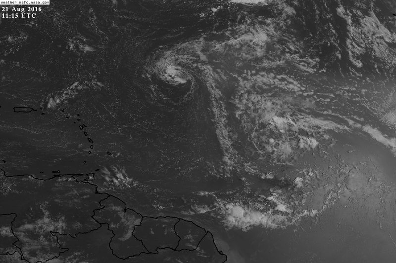
Disorganized showers a few thunderstorms associated with a tropical
wave are located about 1150 miles east of the Lesser Antilles.
Environmental conditions are forecast to be marginally conducive for
development during the next few days, and any development should be
slow to occur. This system is expected to move westward and then
west-northwestward at 15 to 20 mph across the tropical Atlantic
Ocean, through the eastern Caribbean Sea, and then near the Greater
Antilles.
* Formation chance through 48 hours...low...20 percent
* Formation chance through 5 days...medium...50 percent
0 likes   

User avatar
bvigal
S2K Supporter
S2K Supporter
Posts: 2276
Joined: Sun Jul 24, 2005 8:49 am
Location: British Virgin Islands
Contact:

Re: ATL: INVEST 99L - Discussion

#242 Postby bvigal » Sun Aug 21, 2016 7:18 am

Image
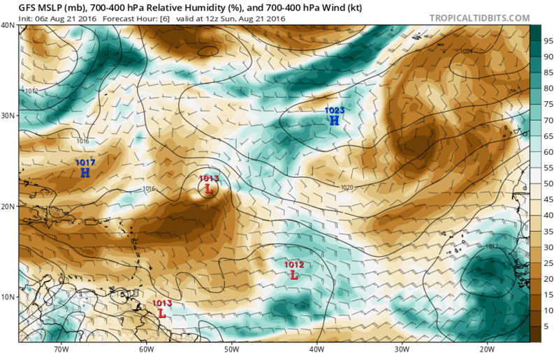
Precip water view of 99L
(This picture will be overwritten tomorrow morning, I no longer keep a photo storage site)
0 likes   

User avatar
MGC
S2K Supporter
S2K Supporter
Posts: 5899
Joined: Sun Mar 23, 2003 9:05 pm
Location: Pass Christian MS, or what is left.

Re: ATL: INVEST 99L - Discussion

#243 Postby MGC » Sun Aug 21, 2016 7:57 am

99L don't look like much this morning. Just a few scattered convective cells. Miles and miles of dry air DEAD ahead of 99L will limit its development chances....perhaps conditions will improve in the Western Atlantic.....MGC
0 likes   

User avatar
NDG
S2K Supporter
S2K Supporter
Posts: 15446
Joined: Sun Jul 09, 2006 10:14 pm
Location: Orlando, FL

Re: ATL: INVEST 99L - Discussion

#244 Postby NDG » Sun Aug 21, 2016 8:20 am

99L is still trapped close to the SAL this morning. The GFS messed up on Friday, really missed the dry environment that 99L was going to encounter. 90L is within a moist environment thus why it has a better chance of development in the short range.

Image
Image
Image
0 likes   

User avatar
Ntxw
Storm2k Moderator
Storm2k Moderator
Posts: 22784
Joined: Wed Oct 21, 2009 6:34 pm
Location: DFW, Texas

Re: ATL: INVEST 99L - Discussion

#245 Postby Ntxw » Sun Aug 21, 2016 8:41 am

Needless to say it needs convection if it's going to do anything.

Image
2 likes   
The above post and any post by Ntxw is NOT an official forecast and should not be used as such. It is just the opinion of the poster and may or may not be backed by sound meteorological data. It is NOT endorsed by any professional institution including Storm2k. For official information, please refer to NWS products.

  Help support Storm2K!
Help Support Storm2K

User avatar
gatorcane
S2K Supporter
S2K Supporter
Posts: 23691
Age: 47
Joined: Sun Mar 13, 2005 3:54 pm
Location: Boca Raton, FL

Re: ATL: INVEST 99L - Discussion

#246 Postby gatorcane » Sun Aug 21, 2016 9:41 am

Bear in mind the NHC 50% chance of development does not reflect development chances if 99l makes it to near the Bahamas where models suggest conditions could be more favorable for development.
0 likes   

User avatar
Blown Away
S2K Supporter
S2K Supporter
Posts: 10145
Joined: Wed May 26, 2004 6:17 am

Re: ATL: INVEST 99L - Discussion

#247 Postby Blown Away » Sun Aug 21, 2016 9:51 am

Image
http://rammb.cira.colostate.edu/product ... r=AL992016

Maybe the very early makings of a LLC??
0 likes   
Hurricane Eye Experience: David 79, Irene 99, Frances 04, Jeanne 04, Wilma 05... EYE COMING MY WAY IN 2024…
Hurricane Brush Experience: Andrew 92, Erin 95, Floyd 99, Matthew 16, Irma 17, Ian 22, Nicole 22…

User avatar
blp
Category 5
Category 5
Posts: 2840
Age: 46
Joined: Thu Sep 09, 2004 7:51 pm
Location: Miami, FL
Contact:

Re: ATL: INVEST 99L - Discussion

#248 Postby blp » Sun Aug 21, 2016 9:55 am

MIMIC TPW is still quite impressive. This is not going away anytime soon despite not showing much convection.

http://tropic.ssec.wisc.edu/real-time/m ... /main.html
1 likes   
The following post is NOT an official forecast and should not be used as such. It is just the opinion of the poster and may or may not be backed by sound meteorological data. It is NOT endorsed by any professional institution including storm2k.org For Official Information please refer to the NHC and NWS products.

User avatar
gatorcane
S2K Supporter
S2K Supporter
Posts: 23691
Age: 47
Joined: Sun Mar 13, 2005 3:54 pm
Location: Boca Raton, FL

Re: ATL: INVEST 99L - Discussion

#249 Postby gatorcane » Sun Aug 21, 2016 10:02 am

Lacking convection at the moment but overall cyclonic spin quite apparent and a good signature as blp pointed out

Image
2 likes   

User avatar
SFLcane
S2K Supporter
S2K Supporter
Posts: 10163
Age: 47
Joined: Sat Jun 05, 2010 1:44 pm
Location: Lake Worth Florida

Re: ATL: INVEST 99L - Discussion

#250 Postby SFLcane » Sun Aug 21, 2016 10:10 am

Sorry folks this isn't going to develop in the term likely never at all. There is your reason why convection goes poof. It's been part of the problem last what few years if not more. Development chances 50% in 5 days? I'd say more like 20% the way I see it.

http://weather.msfc.nasa.gov/GOES/GOES1 ... 3i5hRP.jpg
Last edited by tolakram on Sun Aug 21, 2016 11:54 am, edited 1 time in total.
Reason: removed direct image link
0 likes   

User avatar
cycloneye
Admin
Admin
Posts: 145303
Age: 68
Joined: Thu Oct 10, 2002 10:54 am
Location: San Juan, Puerto Rico

Re: ATL: INVEST 99L - Recon

#251 Postby cycloneye » Sun Aug 21, 2016 10:10 am

For Tuesday Afternoon the first plane to investigate 99L but if Necesarry.

WEATHER RECONNAISSANCE FLIGHTS
CARCAH, NATIONAL HURRICANE CENTER, MIAMI, FL.
1100 AM EDT SUN 21 AUGUST 2016
SUBJECT: TROPICAL CYCLONE PLAN OF THE DAY (TCPOD)
VALID 22/1100Z TO 23/1100Z AUGUST 2016
TCPOD NUMBER.....16-087

I. ATLANTIC REQUIREMENTS
1. NEGATIVE RECONNAISSANCE REQUIREMENTS.
2. OUTLOOK FOR SUCCEEDING DAY: POSSIBLE LOW-LEVEL INVEST MISSION
INTO SYSTEM APPROACHING LESSER ANTILLES NEAR 15.0N 58.0W FOR
23/1800Z. BEGIN 6-HRLY FIXES AT 24/0600Z IF SYSTEM DEVELOPS
0 likes   
Visit the Caribbean-Central America Weather Thread where you can find at first post web cams,radars
and observations from Caribbean basin members Click Here

User avatar
SFLcane
S2K Supporter
S2K Supporter
Posts: 10163
Age: 47
Joined: Sat Jun 05, 2010 1:44 pm
Location: Lake Worth Florida

Re: ATL: INVEST 99L - Recon

#252 Postby SFLcane » Sun Aug 21, 2016 10:14 am

This will more then likely will be cancelled. No need to waste fuel on patch of clouds.
1 likes   

User avatar
cycloneye
Admin
Admin
Posts: 145303
Age: 68
Joined: Thu Oct 10, 2002 10:54 am
Location: San Juan, Puerto Rico

Re: ATL: INVEST 99L - Recon

#253 Postby cycloneye » Sun Aug 21, 2016 10:24 am

SFLcane wrote:This will more then likely will be cancelled. No need to waste fuel on patch of clouds.


Unless there are more than popcorn type clouds.
1 likes   
Visit the Caribbean-Central America Weather Thread where you can find at first post web cams,radars
and observations from Caribbean basin members Click Here

rockyman
Category 5
Category 5
Posts: 1967
Joined: Thu Jun 26, 2003 12:24 pm
Location: Dauphin Island, AL

Re: ATL: INVEST 99L - Discussion

#254 Postby rockyman » Sun Aug 21, 2016 10:33 am

MIMIC shows an absolutely huge system. In general, the larger the circulation, the longer it takes to get going. Part of the circulation envelope will be scraping Hispaniola, but the size of the system will make it more likely to avoid a total "poof".

Also, as Fiona pulls away to the north, 99L should no longer have to "share" the moisture feed from the ITCZ with another system.

http://tropic.ssec.wisc.edu/real-time/m ... /main.html
2 likes   

User avatar
p1nheadlarry
Category 2
Category 2
Posts: 672
Age: 33
Joined: Wed Jan 29, 2014 2:42 pm
Location: SR County FL

Re: ATL: INVEST 99L - Discussion

#255 Postby p1nheadlarry » Sun Aug 21, 2016 10:55 am

gatorcane wrote:Lacking convection at the moment but overall cyclonic spin quite apparent and a good signature as blp pointed out

https://s10.postimg.org/xf9otddvd/vis_lalo_animated.gif


Looks like the coc is closer to 14 than 13 north on that pic
0 likes   
--;->#GoNoles--;->.

User avatar
wxman57
Moderator-Pro Met
Moderator-Pro Met
Posts: 22978
Age: 67
Joined: Sat Jun 21, 2003 8:06 pm
Location: Houston, TX (southwest)

Re: ATL: INVEST 99L - Discussion

#256 Postby wxman57 » Sun Aug 21, 2016 11:23 am

I'd feel more comfortable going for development if the global models showed some support. The Mimic-TPW loop is quite impressive, though, and a number of GFS, EC, and CMC ensembles support development. I don't expect any significant change in status until it passes the NE Caribbean Wed/Thu.
5 likes   

psyclone
S2K Supporter
S2K Supporter
Posts: 4762
Joined: Wed Aug 24, 2005 9:04 pm
Location: palm harbor fl

Re: ATL: INVEST 99L - Discussion

#257 Postby psyclone » Sun Aug 21, 2016 12:04 pm

its best opportunity for development may still reside just beyond the 5 day forecast window. Nevertheless, it will need some persistent convection at some point. But it's a big circulation destined to encounter warmer waters in late August. I wouldn't write it off but it's likely a snooze fest for the next few days.
1 likes   

User avatar
NDG
S2K Supporter
S2K Supporter
Posts: 15446
Joined: Sun Jul 09, 2006 10:14 pm
Location: Orlando, FL

Re: ATL: INVEST 99L - Discussion

#258 Postby NDG » Sun Aug 21, 2016 12:30 pm

psyclone wrote:its best opportunity for development may still reside just beyond the 5 day forecast window. Nevertheless, it will need some persistent convection at some point. But it's a big circulation destined to encounter warmer waters in late August. I wouldn't write it off but it's likely a snooze fest for the next few days.


Warmers might help in instability but it still needs to get away from the capped atmosphere over it, may do that as it starts nearing the Leeward Islands, but there's still a lot of dry air over the Caribbean.

Is over a fairly stable environment right now:

Code: Select all

ate: 6 hour UKMET valid 18Z SUN 21 AUG 16
Station: 15,-45
Latitude:   15.00
Longitude: -45.00
-------------------------------------------------------------------------------
LEV PRES  HGHT  TEMP  DEWP  RH  DD   WETB DIR SPD THETA THE-V THE-W THE-E   W
     mb     m     C     C    %   C     C  deg knt   K     K     K     K    g/kg
-------------------------------------------------------------------------------
  0  850  1521  18.1  16.9  93  1.2  17.3  99  20 305.1 307.8 296.3 348.2 14.43
  1  700  3167  10.6   8.2  85  2.4   9.1  94  16 314.3 316.1 295.4 344.8  9.82
  2  600  4436   3.7  -0.4  75  4.0   1.5  83  11 320.4 321.6 294.4 340.4  6.22
  3  500  5899  -3.8 -13.4  47  9.6  -7.7  62   6 328.4 329.0 293.7 337.7  2.72
  4  400  7624 -15.0                       64   9 335.5                       
  5  300  9737 -30.2                       54  18 342.8                       
  6  250 11006 -40.4                       57  21 346.0                       
  7  200 12487 -52.8                       79  25 349.2                       
  8  150 14274 -68.8                       86  23 351.6                       
  9  100 16645 -76.4                      121  13 380.1                       
TRP                                             0                             
WND                                             0                             

Sounding variables and indices
Freezing level:          550.73 mb =  5157.07 m = 16919.31 ft
Wetbulb zero:            584.13 mb =  4651.44 m = 15260.44 ft
Precipitable water:        1.21 inches
700-500 lapse rate:        5.27 C/km
ThetaE index:            10347.21 C Layer  700.0-  -0.0 mb
Showalter Index:          -0.16 C Risk: Thunderstorms probable
Total Totals Index:       42.57 C Risk: None
  Vertical Totals Index:  21.86 C
  Cross Totals Index:     20.71 C
K Index:                  36.38   Risk: > 80 % chance of thunderstorms
Sweat Index:             247.80   Risk: None
Energy Index:             -2.06   Risk: Severe Thunderstorms probable
0 likes   

User avatar
gatorcane
S2K Supporter
S2K Supporter
Posts: 23691
Age: 47
Joined: Sun Mar 13, 2005 3:54 pm
Location: Boca Raton, FL

Re: ATL: INVEST 99L - Discussion

#259 Postby gatorcane » Sun Aug 21, 2016 12:32 pm

NHC to release outlook within the next 30 minutes. Models have become more bullish (all develop except the Euro which has yet to run) but a little bit outside of the NHC 5-day window when the system clears the islands. So perhaps NHC sticks with 50% for now would be my guess.
0 likes   

User avatar
cycloneye
Admin
Admin
Posts: 145303
Age: 68
Joined: Thu Oct 10, 2002 10:54 am
Location: San Juan, Puerto Rico

Re: ATL: INVEST 99L - Discussion

#260 Postby cycloneye » Sun Aug 21, 2016 12:40 pm

Mentions the Bahamas.

A tropical wave located about 1100 miles east of the Lesser Antilles
is producing disorganized showers and a few thunderstorms. The
proximity of this system to dry air is expected to inhibit
significant development during the next few days while the
disturbance moves westward to west-northwestward at 15 to 20 mph.
Environmental conditions could become more conducive for development
late this week when the system is expected to be near Hispaniola and
the southeastern Bahamas.
* Formation chance through 48 hours...low...10 percent
* Formation chance through 5 days...medium...40 percent
0 likes   
Visit the Caribbean-Central America Weather Thread where you can find at first post web cams,radars
and observations from Caribbean basin members Click Here


Return to “2016”

Who is online

Users browsing this forum: No registered users and 5 guests