
If Fiona is our final storm of August (and this may be a possibility thanks to the MJO stuck in the WPAC), I would suspect we would have a very quiet season
Even my 11/7/2 would be in jepordy
Seasonal Indicators (Beyond Day 16): Instability / SST's / MSLP / Steering / Sal
Moderator: S2k Moderators
Forum rules

The posts in this forum are NOT official forecasts and should not be used as such. They are just the opinion of the poster and may or may not be backed by sound meteorological data. They are NOT endorsed by any professional institution or STORM2K. For official information, please refer to products from the National Hurricane Center and National Weather Service.

Re: Seasonal Indicators (Beyond Day 16): Instability / SST's / MSLP / Steering / Sal
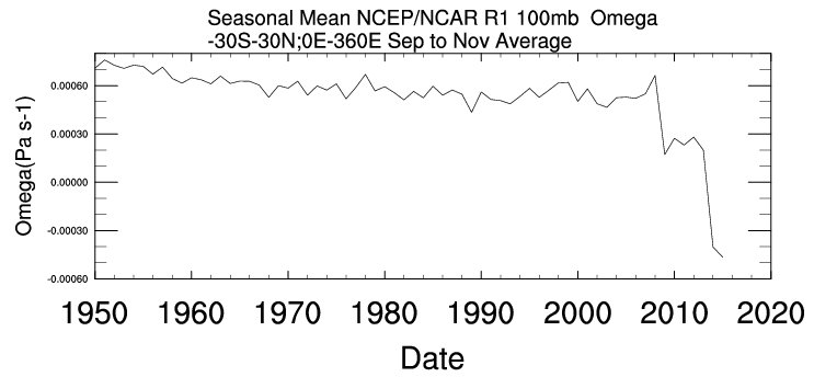
The climate is shifting to a new state, so analogs are losing their old forecasting value:
https://twitter.com/splillo/status/764596445227978753
https://twitter.com/antmasiello/status/765295203347554304
https://twitter.com/splillo/status/764596445227978753
https://twitter.com/antmasiello/status/765295203347554304
0 likes


Re: Seasonal Indicators (Beyond Day 16): Instability / SST's / MSLP / Steering / Sal
LarryWx wrote:That's quite possible. I now agree that hurricanes, themselves, have been a bit underdone on average since 1975 during phase 6 in August vs the average for all August days. However, even with that, there were 2 storms that became not only H's but also major H's during phase 6 in August out of 28 overall Aug MH since 1975: Belle of 1976 and Charley of 2004. So, you never know.
Those are still very slim odds. Regardless though MJO or not the open Atlantic will need hurricanes to keep pace with ACE. At the beginning of the month I mentioned how it was not too important given the low average at the time, however towards the end as we are approaching peak getting to 30 units by September and then racking up another 20+ the first two weeks to keep pace is no easy task without MH trackers.
Of course keep all of them away from land.
As far as the MJO just look at the west pacific now with it. Could you imagine if 4-5 systems were going on at the same time as it is over there in the Atlantic? People would get dizzy going back and forth between threads
0 likes
The above post and any post by Ntxw is NOT an official forecast and should not be used as such. It is just the opinion of the poster and may or may not be backed by sound meteorological data. It is NOT endorsed by any professional institution including Storm2k. For official information, please refer to NWS products.
Help support Storm2K!


Re: Seasonal Indicators (Beyond Day 16): Instability / SST's / MSLP / Steering / Sal
Bocadude85 wrote:Hammy wrote:
This basically supports the Euro being correct with 99L not developing.
The mjo does not need to be in a favorable phase for us to see development in the Atlantic as we just saw with Fiona.
Exactly, it does not mean that there will be no development at all, it just means that any development, which are lower in phase 6, have a lower chance of becoming a hurricane than when the MJO is on Phase 1 & 2.
The strongest sinking motion is over the Indian Ocean not the Atlantic, another thing to add.
1 likes
-
tolakram
- Admin

- Posts: 20186
- Age: 62
- Joined: Sun Aug 27, 2006 8:23 pm
- Location: Florence, KY (name is Mark)
Re: Seasonal Indicators (Beyond Day 16): Instability / SST's / MSLP / Steering / Sal
https://twitter.com/philklotzbach/status/766981155262300160
Not exactly an indicator but I liked the tweet.
Not exactly an indicator but I liked the tweet.
1 likes
M a r k
- - - - -
Join us in chat: Storm2K Chatroom Invite. Android and IOS apps also available.
The posts in this forum are NOT official forecasts and should not be used as such. Posts are NOT endorsed by any professional institution or STORM2K.org. For official information and forecasts, please refer to NHC and NWS products.
-
cycloneye

- Admin
- Posts: 149746
- Age: 69
- Joined: Thu Oct 10, 2002 10:54 am
- Location: San Juan, Puerto Rico
Re: Seasonal Indicators (Beyond Day 16): Instability / SST's / MSLP / Steering / Sal
0 likes
Visit the Caribbean-Central America Weather Thread where you can find at first post web cams,radars
and observations from Caribbean basin members Click Here
and observations from Caribbean basin members Click Here
Re: Seasonal Indicators (Beyond Day 16): Instability / SST's / MSLP / Steering / Sal
tolakram wrote: https://twitter.com/philklotzbach/status/766981155262300160
Not exactly an indicator but I liked the tweet.
Well, happy first day of the most active part of the hurricane season to everyone
2 likes


Re: Seasonal Indicators (Beyond Day 16): Instability / SST's / MSLP / Steering / Sal
In the light of the 2 new systems forming, some bloggers on other weather sites have already called the un-active phase of the Atlantic. I know most of us are amateurs and we're still learning the awesomeness of weather, but I think it's premature to make a call like that now. Model runs shouldn't draw such of a conclusion.
1 likes
The posts or stuff said are NOT an official forecast. Please look to the NHC and NWS for official forecasts and products.
Floyd-1999, Frances-2004, Jeanne-2004, Fay-2008, Beryl-2012, Debby-2012, Colin-2016, Hermine-2016, Julia-2016, Matthew-2016, Irma-2017, Elsa-2021, Idalia-2023, Debby-2024, Helene-2024.
Go Gators! Go Jags!
Floyd-1999, Frances-2004, Jeanne-2004, Fay-2008, Beryl-2012, Debby-2012, Colin-2016, Hermine-2016, Julia-2016, Matthew-2016, Irma-2017, Elsa-2021, Idalia-2023, Debby-2024, Helene-2024.
Go Gators! Go Jags!

Re: Seasonal Indicators (Beyond Day 16): Instability / SST's / MSLP / Steering / Sal
Even without 99L developing, we're going to be ahead of 1998 by the end of the month -if- the GFS/Euro verify with 90L (I'm skeptical of systems north of 20N that far out after last year)--1998 was 5/2/1 (we can extend that out to 5/3/1 since Earl formed August 31 and became a hurricane a few days later). In fact, prior to September 15, the season was at 6/3/1--This year would be at 8/3/1 by the end of August with the models verifying, and that's if literally nothing else forms after 90L before September.
Everything's falling in line with my 1998 analog forecast from July and things getting busy around the third week of August--and even more active given Earl at the start of the month. http://i.imgur.com/AA7iN3f.png
With the suppressive phase of the MJO sitting over the Atlantic it's entirely possible the early part of September could be somewhat quiet (similarly to 1998, with only Frances actually forming during that time). And similarly to 1998 (and possibly 1999) the latter half into October could be busy.
1 likes
The above post is not official and should not be used as such. It is the opinion of the poster and may or may not be backed by sound meteorological data. It is not endorsed by any professional institution or storm2k.org. For official information, please refer to the NHC and NWS products.
Re: Seasonal Indicators (Beyond Day 16): Instability / SST's / MSLP / Steering / Sal
There is a slight difference from 1998 though at this time. During this week heading into the next, both Bonnie and Danielle racked up a whopping ~50 units of ACE. And then early September Georges pumped another 39 units bringing it to 89. That is some extreme quality over quantity. The numbers can be deceptive.
5/3/1 with 50 units vs 8/3/1 and 13 units is a stark contrast. If you compare storm by storm of the two seasons, it's no contest.
5/3/1 with 50 units vs 8/3/1 and 13 units is a stark contrast. If you compare storm by storm of the two seasons, it's no contest.
4 likes
The above post and any post by Ntxw is NOT an official forecast and should not be used as such. It is just the opinion of the poster and may or may not be backed by sound meteorological data. It is NOT endorsed by any professional institution including Storm2k. For official information, please refer to NWS products.
Help support Storm2K!
Help support Storm2K!
-
CYCLONE MIKE
- Category 5

- Posts: 2183
- Joined: Tue Aug 31, 2004 6:04 pm
- Location: Gonzales, LA
Re: Seasonal Indicators (Beyond Day 16): Instability / SST's / MSLP / Steering / Sal
While I dont think we will come close to touching the number of hurricanes compared to '98 nor the north gulf seeing as much action even if it is weak short lived. The one thing I do agree with though is the vast majority of what does develop will recurve out in the atlantic like '98.
1 likes
This post is NOT AN OFFICIAL FORECAST and should not be used as such. It is just the opinion of the poster and may or may not be backed by sound meteorological data. It is NOT endorsed by any professional institution including storm2k.org. For Official Information please refer to the NHC and NWS products.

Re: Seasonal Indicators (Beyond Day 16): Instability / SST's / MSLP / Steering / Sal
CYCLONE MIKE wrote:While I dont think we will come close to touching the number of hurricanes compared to '98 nor the north gulf seeing as much action even if it is weak short lived. The one thing I do agree with though is the vast majority of what does develop will recurve out in the atlantic like '98.
That was a split season though with 7 landfalls (1 a brush by @ OBX) and 7 recurves. My guess for this year was also 14 named but not necessarily based off 98. I think there was something like 20,000 or more fatalities that year with Mitch, so hopefully Honduras doesn't see anything like that in late October!
0 likes
-
centuryv58

- Tropical Storm

- Posts: 233
- Age: 67
- Joined: Sat Jul 30, 2016 1:24 pm
- Location: Southeast Florida
Re: Seasonal Indicators (Beyond Day 16): Instability / SST's / MSLP / Steering / Sal
Steve wrote:CYCLONE MIKE wrote:While I dont think we will come close to touching the number of hurricanes compared to '98 nor the north gulf seeing as much action even if it is weak short lived. The one thing I do agree with though is the vast majority of what does develop will recurve out in the atlantic like '98.
That was a split season though with 7 landfalls (1 a brush by @ OBX) and 7 recurves. My guess for this year was also 14 named but not necessarily based off 98. I think there was something like 20,000 or more fatalities that year with Mitch, so hopefully Honduras doesn't see anything like that in late October!
NOAA probably knows more about the expected number of named storms (15+) this year than we do. It will be an active year nonetheless.
1 likes
Re: Seasonal Indicators (Beyond Day 16): Instability / SST's / MSLP / Steering / Sal
Ntxw wrote:There is a slight difference from 1998 though at this time. During this week heading into the next, both Bonnie and Danielle racked up a whopping ~50 units of ACE. And then early September Georges pumped another 39 units bringing it to 89. That is some extreme quality over quantity. The numbers can be deceptive.
5/3/1 with 50 units vs 8/3/1 and 13 units is a stark contrast. If you compare storm by storm of the two seasons, it's no contest.
George wasn't early September, didn't even become a hurricane until the 18th; and you're comparing current ACE, on August 21, with the potential August 31 numbers--if we get a major hurricane we're not going to remain at 13 ACE--1998 was only at 4.1 at the present time.
1 likes
The above post is not official and should not be used as such. It is the opinion of the poster and may or may not be backed by sound meteorological data. It is not endorsed by any professional institution or storm2k.org. For official information, please refer to the NHC and NWS products.
Re: Seasonal Indicators (Beyond Day 16): Instability / SST's / MSLP / Steering / Sal
I was responding to your comment by the end of the month with the assumptions. By then both Bonnie and Danielle had contributed. Regardless, ACE wise to keep up with 1998 is no easy task, it was a very hyperactive season.
Lets assume 90L will get 25 units by the end of this month. You would still need another storm of that caliber to keep up with both Bonnie and Danielle
Lets assume 90L will get 25 units by the end of this month. You would still need another storm of that caliber to keep up with both Bonnie and Danielle
1 likes
The above post and any post by Ntxw is NOT an official forecast and should not be used as such. It is just the opinion of the poster and may or may not be backed by sound meteorological data. It is NOT endorsed by any professional institution including Storm2k. For official information, please refer to NWS products.
Help support Storm2K!
Help support Storm2K!
Re: Seasonal Indicators (Beyond Day 16): Instability / SST's / MSLP / Steering / Sal
98 aside, at the very least if 90L delivers (and it may be a formidable cane) it would keep ACE close to seasonal normal which is much needed, especially since it will probably be a fish storm. A nice one to track
1 likes
The above post and any post by Ntxw is NOT an official forecast and should not be used as such. It is just the opinion of the poster and may or may not be backed by sound meteorological data. It is NOT endorsed by any professional institution including Storm2k. For official information, please refer to NWS products.
Help support Storm2K!
Help support Storm2K!
Re: Seasonal Indicators (Beyond Day 16): Instability / SST's / MSLP / Steering / Sal
Ntxw wrote:I was responding to your comment by the end of the month with the assumptions. By then both Bonnie and Danielle had contributed. Regardless, ACE wise to keep up with 1998 is no easy task, it was a very hyperactive season.
Lets assume 90L will get 25 units by the end of this month. You would still need another storm of that caliber to keep up with both Bonnie and Danielle
Fair enough, but my 1998 comparison was primarily numbers--that we would be largely quiet until around the last third of August, made mainly in reply to people who were trying to call the season dead because we weren't at record activity by the middle of July. I don't think we'll have an exact repeat with tracks/ACE/etc but I think the numbers as well as how the season went, getting off to a (somewhat) late start with the stronger storms, with relatively short active periods followed by quiet periods, is a good analog for this year, rather than something like 2013 or something like 2004/05 with near constant activity.
0 likes
The above post is not official and should not be used as such. It is the opinion of the poster and may or may not be backed by sound meteorological data. It is not endorsed by any professional institution or storm2k.org. For official information, please refer to the NHC and NWS products.
Re: Seasonal Indicators (Beyond Day 16): Instability / SST's / MSLP / Steering / Sal
I feel as if much of this year will be quantity over quality. Already we're about to be at the "G" name, but a lot of the storms so far have been relatively short-lived, and yes, this means lower ACE than usual. We shall see, as 90L might become major Hurricane Gaston, and generate quite a bit of units, but in general, that's not been the trend so far.
0 likes
Igor 2010, Sandy 2012, Fay 2014, Gonzalo 2014, Joaquin 2015, Nicole 2016, Humberto 2019, Imelda 2025
I am only a tropical weather enthusiast. My predictions are not official and may or may not be backed by sound meteorological data. For official information, please refer to the NHC and NWS products.
I am only a tropical weather enthusiast. My predictions are not official and may or may not be backed by sound meteorological data. For official information, please refer to the NHC and NWS products.
-
tolakram
- Admin
- Posts: 20186
- Age: 62
- Joined: Sun Aug 27, 2006 8:23 pm
- Location: Florence, KY (name is Mark)
Re: Seasonal Indicators (Beyond Day 16): Instability / SST's / MSLP / Steering / Sal
Instability still rising.

0 likes
M a r k
- - - - -
Join us in chat: Storm2K Chatroom Invite. Android and IOS apps also available.
The posts in this forum are NOT official forecasts and should not be used as such. Posts are NOT endorsed by any professional institution or STORM2K.org. For official information and forecasts, please refer to NHC and NWS products.
- - - - -
Join us in chat: Storm2K Chatroom Invite. Android and IOS apps also available.
The posts in this forum are NOT official forecasts and should not be used as such. Posts are NOT endorsed by any professional institution or STORM2K.org. For official information and forecasts, please refer to NHC and NWS products.
Who is online
Users browsing this forum: No registered users and 145 guests