Seasonal Indicators (Beyond Day 16): Instability / SST's / MSLP / Steering / Sal
Moderator: S2k Moderators
Forum rules

The posts in this forum are NOT official forecasts and should not be used as such. They are just the opinion of the poster and may or may not be backed by sound meteorological data. They are NOT endorsed by any professional institution or STORM2K. For official information, please refer to products from the National Hurricane Center and National Weather Service.
-
Socalhurcnegirl227
- Category 1

- Posts: 267
- Age: 36
- Joined: Mon Jun 06, 2016 6:39 pm
- Location: Santa Barbara, CA
Re: Seasonal Indicators (Beyond Day 16): Instability / SST's / MSLP / Steering / Sal
I could be wrong because obviously i am nowhere near expert levels, i think we may get more "homegrown" storms this season rather than the MDR and Cape Verde storms. While i highly doubt we'll see a Katrina repeat, (altho the flooding going on in LA is reminiscent of Katrina just lacking some hurricane conditions), Katrina was a homegrown storm. i think theres a better likely chance if conditions become favorable for this to happen than to have the other storms trek across and hit suriving all the factors that need to be inplace. just my thought.
0 likes
"I'm a wandress, i'm a one night stand,
dont belong to no city, dont belong to no man
i'm the violence in the pouring rain,
I'm a hurricane"
dont belong to no city, dont belong to no man
i'm the violence in the pouring rain,
I'm a hurricane"
-
Hybridstorm_November2001

- S2K Supporter

- Posts: 2817
- Joined: Sat Aug 21, 2004 2:50 pm
- Location: SW New Brunswick, Canada
- Contact:
Re: Seasonal Indicators (Beyond Day 16): Instability / SST's / MSLP / Steering / Sal
Technically Hurricane Katrina wasn't homebrew in her origins. Rather Katrina formed by way of an interaction between the remnants of TD Ten and a separate Tropical Wave in the Bahamas (both of which made their way across from Coastal West Africa). 
1 likes
-
centuryv58

- Tropical Storm

- Posts: 233
- Age: 67
- Joined: Sat Jul 30, 2016 1:24 pm
- Location: Southeast Florida
Re: Seasonal Indicators (Beyond Day 16): Instability / SST's / MSLP / Steering / Sal
SFLcane wrote:All I know is it's gonna have to be one heck of peak season to come close to NOAA's seasonal prediction. Personally I think there is something much depear going on in the Atlantic for whatever reason everything is a struggle the stars have to alein right just to get a minimal tropical storm these days. Completely agree with gulfcoast flooding just a few miles S and it could have been a powerful hurricane but goes to show even a TD can cause substantial damage. I just can't see 5-6 more hurricanes with the " current" conditions. It's interesting shear was below normal across the Caribbean and gulf for most of June and July but has since increased. I'd just like to know what's going on basin wide.
So, what do you know that NOAA does not know? I am not being mean with the comment, but several people, including a ProMet or two, seem to think they know more than national Met organizations. Its very puzzling to me.
1 likes

Re: Seasonal Indicators (Beyond Day 16): Instability / SST's / MSLP / Steering / Sal
centuryv58 wrote:SFLcane wrote:All I know is it's gonna have to be one heck of peak season to come close to NOAA's seasonal prediction. Personally I think there is something much depear going on in the Atlantic for whatever reason everything is a struggle the stars have to alein right just to get a minimal tropical storm these days. Completely agree with gulfcoast flooding just a few miles S and it could have been a powerful hurricane but goes to show even a TD can cause substantial damage. I just can't see 5-6 more hurricanes with the " current" conditions. It's interesting shear was below normal across the Caribbean and gulf for most of June and July but has since increased. I'd just like to know what's going on basin wide.
So, what do you know that NOAA does not know? I am not being mean with the comment, but several people, including a ProMet or two, seem to think they know more than national Met organizations. Its very puzzling to me.
One thing I'm wondering forecast-wise, especially with the seasonal forecasts, is if they might have the right pattern but they're too fast, so what should've been a more favorable July/early August months ago will instead translate into September/October instead.
1 likes
The above post is not official and should not be used as such. It is the opinion of the poster and may or may not be backed by sound meteorological data. It is not endorsed by any professional institution or storm2k.org. For official information, please refer to the NHC and NWS products.

Re: Seasonal Indicators (Beyond Day 16): Instability / SST's / MSLP / Steering / Sal
Point made on Fox 8 tonight was historically,80% of activity is after today anyway (assuming they meant classified systems) Also we are at below 11 ACE. There have been 2 seasons since the AMO flip to log less than 50 ace. That was 1997 and 2013. Bet the ranch we will be seeing > 50 ACE this year.
0 likes

Re: Seasonal Indicators (Beyond Day 16): Instability / SST's / MSLP / Steering / Sal
centuryv58 wrote:SFLcane wrote:All I know is it's gonna have to be one heck of peak season to come close to NOAA's seasonal prediction. Personally I think there is something much depear going on in the Atlantic for whatever reason everything is a struggle the stars have to alein right just to get a minimal tropical storm these days. Completely agree with gulfcoast flooding just a few miles S and it could have been a powerful hurricane but goes to show even a TD can cause substantial damage. I just can't see 5-6 more hurricanes with the " current" conditions. It's interesting shear was below normal across the Caribbean and gulf for most of June and July but has since increased. I'd just like to know what's going on basin wide.
So, what do you know that NOAA does not know? I am not being mean with the comment, but several people, including a ProMet or two, seem to think they know more than national Met organizations. Its very puzzling to me.
National met organizations are made up of mets with the same qualifications as many of the mets on this board. Stop with the thinking that NOAA is God
2 likes
-
Hurricaneman

- Category 5

- Posts: 7404
- Age: 45
- Joined: Tue Aug 31, 2004 3:24 pm
- Location: central florida
Re: Seasonal Indicators (Beyond Day 16): Instability / SST's / MSLP / Steering / Sal
What needs to be understood by people is that all forecasts are a guess and even with the pros too you either get it right or wrong and what a pro will do is find out where their forecast went wrong and learn from it
This season from here on out looks like it could be quite busy and maybe even non-stop until October
The posts in this forum are NOT official forecast and should not be used as such. They are just the opinion of the poster and may or may not be backed by sound meteorological data. They are NOT endorsed by any professional institution or STORM2K. For official information, please refer to products from the National Hurricane Center and National Weather Service
2 likes
-
TropicalAnalystwx13

- Category 5
- Posts: 2109
- Age: 28
- Joined: Tue Jul 19, 2011 8:20 pm
- Location: Wilmington, NC
- Contact:
Re: Seasonal Indicators (Beyond Day 16): Instability / SST's / MSLP / Steering / Sal
I still feel confident about an active September and October. Right now, above-average shear dictates the Gulf and Caribbean, a huge reversal from the near-record low upper-level winds witnessed late month. The TUTT providing the shear is expected to stretch out over the coming two weeks, which should return shear to normal values across the Caribbean. In the MDR, shear is well below-average while the atmosphere has been slightly drier than normal. The biggest thing at this point is we need to get the MJO out of the West Pacific. To be clear, the MJO being there is not an end-all; we've seen Fiona, and we may get more storms over the coming week to two as a series of vigorous waves move off Africa. Having at least some semblance of upward motion over the basin would do wonders for activity though. The upward phase is stuck farther west thanks to the ongoing monsoonal gyre, but there are signs it may begin to progress by the end of the month and the first week of September.
The only thing we can do at this point is let time progress! I still feel comfortable in above-average activity but near-normal ACE.
The only thing we can do at this point is let time progress! I still feel comfortable in above-average activity but near-normal ACE.
2 likes
Re: Seasonal Indicators (Beyond Day 16): Instability / SST's / MSLP / Steering / Sal
TropicalAnalystwx13 wrote:I still feel confident about an active September and October. Right now, above-average shear dictates the Gulf and Caribbean, a huge reversal from the near-record low upper-level winds witnessed late month. The TUTT providing the shear is expected to stretch out over the coming two weeks, which should return shear to normal values across the Caribbean. In the MDR, shear is well below-average while the atmosphere has been slightly drier than normal. The biggest thing at this point is we need to get the MJO out of the West Pacific. To be clear, the MJO being there is not an end-all; we've seen Fiona, and we may get more storms over the coming week to two as a series of vigorous waves move off Africa. Having at least some semblance of upward motion over the basin would do wonders for activity though. The upward phase is stuck farther west thanks to the ongoing monsoonal gyre, but there are signs it may begin to progress by the end of the month and the first week of September.
The only thing we can do at this point is let time progress! I still feel comfortable in above-average activity but near-normal ACE.
I completely agree. Fiona is just the beginning of a non-stop train of storms through September, and I also predict a more active October this year. Conditions should improve as we move into fall, and shear in the Caribbean should return to normal. Already we can see two other waves over Africa that could become Gaston and Hermine. Most of the season is ahead.
0 likes
Igor 2010, Sandy 2012, Fay 2014, Gonzalo 2014, Joaquin 2015, Nicole 2016, Humberto 2019, Imelda 2025
I am only a tropical weather enthusiast. My predictions are not official and may or may not be backed by sound meteorological data. For official information, please refer to the NHC and NWS products.
I am only a tropical weather enthusiast. My predictions are not official and may or may not be backed by sound meteorological data. For official information, please refer to the NHC and NWS products.

Re: Seasonal Indicators (Beyond Day 16): Instability / SST's / MSLP / Steering / Sal
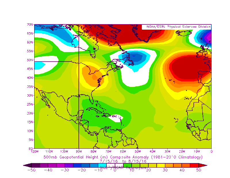
Heights have been lower than average across the north central Atlantic during the past month, makes sense the track that Fiona is taking or any future CV storms if the central Atlantic weakness stays put through the next few weeks. Notice the higher than average heights across the NE US during the past few weeks.
Pattern is very similar to Aug-Sept 2005 when most storms that formed east of 50W recurved out to sea. But one thing is the sypnotic pattern and another thing is the atmospheric conditions, fairly different to 2005.
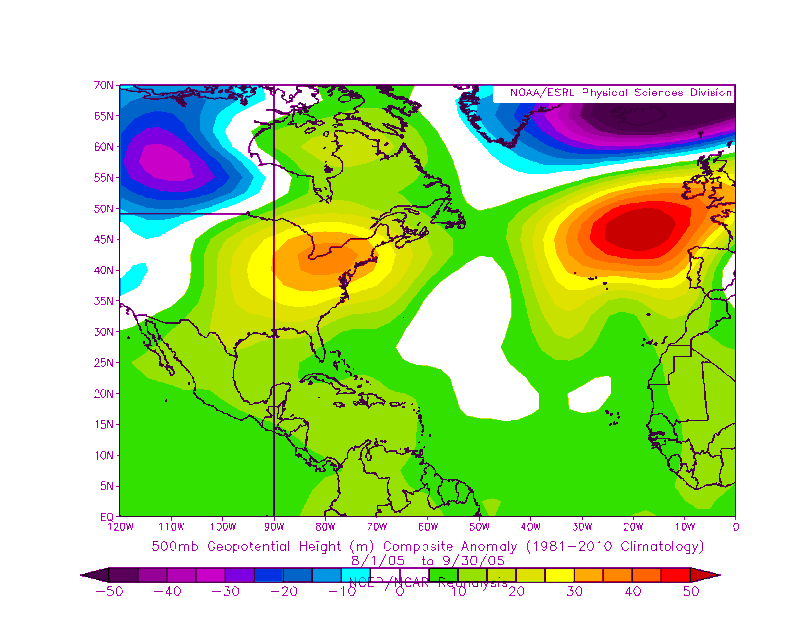
Pattern is very similar to Aug-Sept 2005 when most storms that formed east of 50W recurved out to sea. But one thing is the sypnotic pattern and another thing is the atmospheric conditions, fairly different to 2005.
0 likes

Re: Seasonal Indicators (Beyond Day 16): Instability / SST's / MSLP / Steering / Sal
I'm just afraid of anything that goes into the GOM as a named storm let a lone a Hurricane, the Gulf is ripe and ready to feed a monster or two this season. And since all of Louisiana south of the Hwy 190 corridor (look on a map and you will see that is where the majority of the population lives), I'm talking from the Texas Line to the Mississippi Line, is just soaked and can't take much more if any. National media hasn't shown the full extent of the damage just around Baton Rouge and the River Parishes, but it is a lot worse than they are saying.
0 likes
Personal Forecast Disclaimer:
The posts in this forum are NOT official forecast and should not be used as such. They are just the opinion of the poster and may or may not be backed by sound meteorological data. They are NOT endorsed by any professional institution or storm2k.org. For official information, please refer to the NHC and NWS products.
The posts in this forum are NOT official forecast and should not be used as such. They are just the opinion of the poster and may or may not be backed by sound meteorological data. They are NOT endorsed by any professional institution or storm2k.org. For official information, please refer to the NHC and NWS products.
-
TheStormExpert
Re: Seasonal Indicators (Beyond Day 16): Instability / SST's / MSLP / Steering / Sal
Blinhart wrote:I'm just afraid of anything that goes into the GOM as a named storm let a lone a Hurricane, the Gulf is ripe and ready to feed a monster or two this season. And since all of Louisiana south of the Hwy 190 corridor (look on a map and you will see that is where the majority of the population lives), I'm talking from the Texas Line to the Mississippi Line, is just soaked and can't take much more if any. National media hasn't shown the full extent of the damage just around Baton Rouge and the River Parishes, but it is a lot worse than they are saying.
Yeah the GoM is ripe and ready and that tropical low pressure system that just dumped tons of rain in Louisiana would've been a significant tropical cyclone if it had been a couple hundred miles south or so sitting over the GoM for some time.
0 likes
Re: Seasonal Indicators (Beyond Day 16): Instability / SST's / MSLP / Steering / Sal
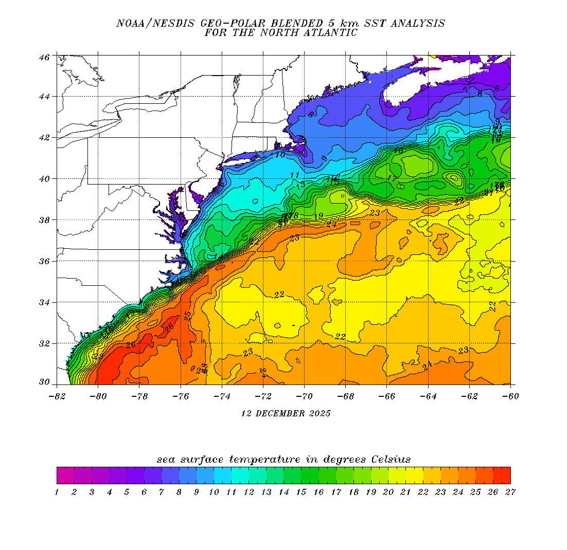
https://mobile.twitter.com/BigJoeBastar ... 0862090240
1) Note that per JB, the SST anomalies overall are the warmest of the satellite era for this time of year off of the US east coast. So, IF there were to be a TC in this area, this could be really bad news for coastal residents.
2) JB also notes the sharp cooling to cooler than normal over the NE gulf just offshore due to the very heavy rains. I'm assuming this was largely due to days of lots of cloudcover resulting in low levels of solar radiation in addition to cooler temperatures down to the surface due to the rains, themselves. However, I wonder if there was also a nontrivial additional amount of very shortterm cooling due to the widespread very heavy rains, themselves, being that the temperature of the raindrops had to have been a good number of degrees cooler than the previously very warm SST's. I'm guessing these anomalies will warm back up quite a bit over the next week or so even if they don't get back up to as high as they were before this heavy rain.
0 likes
Personal Forecast Disclaimer:
The posts in this forum are NOT official forecasts and should not be used as such. They are just the opinion of the poster and may or may not be backed by sound meteorological data. They are NOT endorsed by any professional institution or storm2k.org. For official information, please refer to the NHC and NWS products.
The posts in this forum are NOT official forecasts and should not be used as such. They are just the opinion of the poster and may or may not be backed by sound meteorological data. They are NOT endorsed by any professional institution or storm2k.org. For official information, please refer to the NHC and NWS products.
Re: Seasonal Indicators (Beyond Day 16): Instability / SST's / MSLP / Steering / Sal
0 likes
Re: Seasonal Indicators (Beyond Day 16): Instability / SST's / MSLP / Steering / Sal
LarryWx wrote:https://mobile.twitter.com/BigJoeBastardi/status/766253510862090240
1) Note that per JB, the SST anomalies overall are the warmest of the satellite era for this time of year off of the US east coast. So, IF there were to be a TC in this area, this could be really bad news for coastal residents.
2) JB also notes the sharp cooling to cooler than normal over the NE gulf just offshore due to the very heavy rains. I'm assuming this was largely due to days of lots of cloudcover resulting in low levels of solar radiation in addition to cooler temperatures down to the surface due to the rains, themselves. However, I wonder if there was also a nontrivial additional amount of very shortterm cooling due to the widespread very heavy rains, themselves, being that the temperature of the raindrops had to have been a good number of degrees cooler than the previously very warm SST's. I'm guessing these anomalies will warm back up quite a bit over the next week or so even if they don't get back up to as high as they were before this heavy rain.
Yes, the cooling in the NE GOM had to do more with cloud cover & precip for days instead of upwelling and now probably because of runoffs along the immediate coastal areas, but as typical for this time of the year the SSTs bounce back very quickly. Looking at the buoys this morning SSTs are in the mid 80s, still plenty warm and I am sure that by next week they will be back into the upper 80s to near 90.
The NE coastal waters of FL are cooler than surrounding areas because of typical upwelling this time of the year, last week there was one day that Daytona beach reported a surf temp of 73 degrees!!! But now is back up to the low 80s. This also happens along the northern coast of the Yucatan Peninsula this time of the year.

Near 80 deg F waters are just a few miles away from Long Island, dangerous indeed if they get struck by a hurricane as it will have warm enough waters almost all the way to landfall.
1 likes
Re: Seasonal Indicators (Beyond Day 16): Instability / SST's / MSLP / Steering / Sal
Also, I saw where you mentioned in another thread that the Atlantic basin doesn't have all that unfavorable conditions for TC's considering we are in phase 6. Many folks likely aren't aware that the Atlantic basin has had decent production during phase 6 in August and actually that phase was one of the most active for geneses during August since 1995! The Atlantic had at least one TS genesis more than half the time when there was a phase 6 in August going back to 1975 (where the model forecast consensus is concentrated), including three of which later were H hits on the US: Belle of 1976, Charley of 1986, and Charley of 2004.
1976: Belle
1981: Cindy, Dennis
1986: Charley
1990: Hortense
1993: Bret
2004: Bonnie, Charley, Danielle, Earl
2005: Harvey, Irene
2012; Ernesto
2016: Fiona
Last edited by LarryWx on Fri Aug 19, 2016 12:04 am, edited 1 time in total.
1 likes
Personal Forecast Disclaimer:
The posts in this forum are NOT official forecasts and should not be used as such. They are just the opinion of the poster and may or may not be backed by sound meteorological data. They are NOT endorsed by any professional institution or storm2k.org. For official information, please refer to the NHC and NWS products.
The posts in this forum are NOT official forecasts and should not be used as such. They are just the opinion of the poster and may or may not be backed by sound meteorological data. They are NOT endorsed by any professional institution or storm2k.org. For official information, please refer to the NHC and NWS products.
Re: Seasonal Indicators (Beyond Day 16): Instability / SST's / MSLP / Steering / Sal
It may be mid-September before we see another hurricane after checking the MJO, it doesn't seem to move anywhere close to the Atlantic as per any of the reliable forecasts.
0 likes
The above post is not official and should not be used as such. It is the opinion of the poster and may or may not be backed by sound meteorological data. It is not endorsed by any professional institution or storm2k.org. For official information, please refer to the NHC and NWS products.
Re: Seasonal Indicators (Beyond Day 16): Instability / SST's / MSLP / Steering / Sal
Hammy wrote:It may be mid-September before we see another hurricane after checking the MJO, it doesn't seem to move anywhere close to the Atlantic as per any of the reliable forecasts.
Hammy,
You might have missed the post right above yours that shows that phase 6, where the MJO is projected to stay in/near for the rest of August per the Euro ensemble and some other models, has actually been one of the most active since 1995 for Atlantic genesis rates in August.
0 likes
Personal Forecast Disclaimer:
The posts in this forum are NOT official forecasts and should not be used as such. They are just the opinion of the poster and may or may not be backed by sound meteorological data. They are NOT endorsed by any professional institution or storm2k.org. For official information, please refer to the NHC and NWS products.
The posts in this forum are NOT official forecasts and should not be used as such. They are just the opinion of the poster and may or may not be backed by sound meteorological data. They are NOT endorsed by any professional institution or storm2k.org. For official information, please refer to the NHC and NWS products.
Re: Seasonal Indicators (Beyond Day 16): Instability / SST's / MSLP / Steering / Sal
LarryWx wrote:Hammy wrote:It may be mid-September before we see another hurricane after checking the MJO, it doesn't seem to move anywhere close to the Atlantic as per any of the reliable forecasts.
Hammy,
You might have missed the post right above yours that shows that phase 6, where the MJO is projected to stay in/near for the rest of August per the Euro ensemble and some other models, has actually been one of the most active since 1995 for Atlantic genesis rates in August.
I did indeed see the post, and we may very well have 3-5 storms form before then. But with a few exceptions the storms listed in that post struggled and more than likely the storms this year that form during that phase will as well, as Fiona is currently doing.
0 likes
The above post is not official and should not be used as such. It is the opinion of the poster and may or may not be backed by sound meteorological data. It is not endorsed by any professional institution or storm2k.org. For official information, please refer to the NHC and NWS products.
Re: Seasonal Indicators (Beyond Day 16): Instability / SST's / MSLP / Steering / Sal
Hammy wrote:LarryWx wrote:Hammy wrote:It may be mid-September before we see another hurricane after checking the MJO, it doesn't seem to move anywhere close to the Atlantic as per any of the reliable forecasts.
Hammy,
You might have missed the post right above yours that shows that phase 6, where the MJO is projected to stay in/near for the rest of August per the Euro ensemble and some other models, has actually been one of the most active since 1995 for Atlantic genesis rates in August.
I did indeed see the post, and we may very well have 3-5 storms form before then. But with a few exceptions the storms listed in that post struggled and more than likely the storms this year that form during that phase will as well, as Fiona is currently doing.
Note that 5 of those 7 years that I listed (excluding 2016 since it isn't finished) with formations during August in phase 6 had at least one H come out of those.
0 likes
Personal Forecast Disclaimer:
The posts in this forum are NOT official forecasts and should not be used as such. They are just the opinion of the poster and may or may not be backed by sound meteorological data. They are NOT endorsed by any professional institution or storm2k.org. For official information, please refer to the NHC and NWS products.
The posts in this forum are NOT official forecasts and should not be used as such. They are just the opinion of the poster and may or may not be backed by sound meteorological data. They are NOT endorsed by any professional institution or storm2k.org. For official information, please refer to the NHC and NWS products.
Who is online
Users browsing this forum: No registered users and 46 guests