
ATL: EARL - Remnants - Discussion
Moderator: S2k Moderators
-
tropicwatch

- Category 5

- Posts: 3426
- Age: 62
- Joined: Sat Jun 02, 2007 10:01 am
- Location: The Villages, Florida
- Contact:
Re: ATL: INVEST 97L - Discussion
WOW, look at the setup above 97L.
1 likes
Tropicwatch
Agnes 72', Eloise 75, Elena 85', Kate 85', Charley 86', Florence 88', Beryl 94', Dean 95', Erin 95', Opal 95', Earl 98', Georges 98', Ivan 2004', Arlene 2005', Dennis 2005', Ida 2009' Debby 2012' Irma 2017' Michael 2018'
Agnes 72', Eloise 75, Elena 85', Kate 85', Charley 86', Florence 88', Beryl 94', Dean 95', Erin 95', Opal 95', Earl 98', Georges 98', Ivan 2004', Arlene 2005', Dennis 2005', Ida 2009' Debby 2012' Irma 2017' Michael 2018'

-
tarheelprogrammer

- S2K Supporter

- Posts: 1793
- Joined: Mon Mar 28, 2016 9:25 pm
- Location: Raleigh, NC area (Garner, NC)
Re: ATL: INVEST 97L - Discussion
panamatropicwatch wrote:WOW, look at the setup above 97L.
WOW so why would it not strengthen?
0 likes
My posts are not official forecasts. They are just my opinion and may or may not be backed by sound meteorological data. They are NOT endorsed by any professional institution or storm2k.org. For official information, please refer to the NHC and NWS products.
Re: ATL: INVEST 97L - Discussion
why won't it immediately intensify?
As I said before, low level winds not favorable enough
Far too often posters here, as well as many forecasters, only look at SST, upper winds, and water vapor content. One must also look at the low level winds, as well as the mid level winds. Both the low and mid level winds are not that great. There is an easterly jet affecting this, which is almost always associated with the SAL. In addition, we may be entering into an area of low level divergence, which is extremely unfavorable. Mathematically, this can not intensify unless the upper divergence is beyond great when you have low level divergence
1 likes
-
Nikki

- S2K Supporter
- Posts: 291
- Joined: Mon Jun 21, 2010 3:38 pm
- Location: Santa Fe, TX (yes I typed that right TEXAS not New Mexico, I am about 20 miles from Galveston, TX)
Re: ATL: INVEST 97L - Discussion
ronjon wrote:Really wrapping up tonite on SAT. When is RECON scheduled?
Recon is scheduled for Tuesday, if needed.
0 likes
My name is Nicole and this is what I go by in Storm2k chat! Come chat with us! We have fun in there too!!
A teacher's purpose is not to create students in her own image, but to develop students who can create their own image. ~Author Unknown
Alicia, Allison, Rita, Ike
A teacher's purpose is not to create students in her own image, but to develop students who can create their own image. ~Author Unknown
Alicia, Allison, Rita, Ike
-
tropicwatch
- Category 5
- Posts: 3426
- Age: 62
- Joined: Sat Jun 02, 2007 10:01 am
- Location: The Villages, Florida
- Contact:
Re: ATL: INVEST 97L - Discussion
ronjon wrote:Really wrapping up tonite on SAT. When is RECON scheduled?
As of now not until the 3rd.
000
NOUS42 KNHC 311448
REPRPD
WEATHER RECONNAISSANCE FLIGHTS
CARCAH, NATIONAL HURRICANE CENTER, MIAMI, FL.
1045 AM EDT SUN 31 JULY 2016
SUBJECT: TROPICAL CYCLONE PLAN OF THE DAY (TCPOD)
VALID 01/1100Z TO 02/1100Z AUGUST 2016
TCPOD NUMBER.....16-066
I. ATLANTIC REQUIREMENTS
1. NEGATIVE RECONNAISSANCE REQUIREMENTS.
2. OUTLOOK FOR SUCCEEDING DAY: PROBABLE LOW-LEVEL INVEST MISSION
OVER WESTERN CARIBBEAN NEAR 16.5N 80.0W FOR 02/1800Z. BEGIN
6-HRLY FIXES AT 03/0600Z IF SYSTEM DEVELOPS.
II. PACIFIC REQUIREMENTS
1. NEGATIVE RECONNAISSANCE REQUIREMENTS.
2. OUTLOOK FOR SUCCEEDING DAY.....NEGATIVE.
$$
SEF
NNNN
0 likes
Tropicwatch
Agnes 72', Eloise 75, Elena 85', Kate 85', Charley 86', Florence 88', Beryl 94', Dean 95', Erin 95', Opal 95', Earl 98', Georges 98', Ivan 2004', Arlene 2005', Dennis 2005', Ida 2009' Debby 2012' Irma 2017' Michael 2018'
Agnes 72', Eloise 75, Elena 85', Kate 85', Charley 86', Florence 88', Beryl 94', Dean 95', Erin 95', Opal 95', Earl 98', Georges 98', Ivan 2004', Arlene 2005', Dennis 2005', Ida 2009' Debby 2012' Irma 2017' Michael 2018'


Re: ATL: INVEST 97L - Discussion
Is it possible that the center is relocated under the ball of convection south of Puerto Rico? Or in the process anyway. If so, then the models have the center fix more south of where the convection is but I'm not a Met.
2 likes
The posts or stuff said are NOT an official forecast. Please look to the NHC and NWS for official forecasts and products.
Floyd-1999, Frances-2004, Jeanne-2004, Fay-2008, Beryl-2012, Debby-2012, Colin-2016, Hermine-2016, Julia-2016, Matthew-2016, Irma-2017, Elsa-2021, Idalia-2023, Debby-2024, Helene-2024.
Go Gators! Go Jags!
Floyd-1999, Frances-2004, Jeanne-2004, Fay-2008, Beryl-2012, Debby-2012, Colin-2016, Hermine-2016, Julia-2016, Matthew-2016, Irma-2017, Elsa-2021, Idalia-2023, Debby-2024, Helene-2024.
Go Gators! Go Jags!
Re: ATL: INVEST 97L - Discussion
Alyono wrote:why won't it immediately intensify?
As I said before, low level winds not favorable enough
Far too often posters here, as well as many forecasters, only look at SST, upper winds, and water vapor content. One must also look at the low level winds, as well as the mid level winds. Both the low and mid level winds are not that great. There is an easterly jet affecting this, which is almost always associated with the SAL. In addition, we may be entering into an area of low level divergence, which is extremely unfavorable. Mathematically, this can not intensify unless the upper divergence is beyond great when you have low level divergence
I understand what you are saying Alyono but what I am seeing does not see to corroborate with what you just said.Not being disrespectful just observing what I see.Kevin
If I had to pick fix for system 16'N 68'W
http://www.ssd.noaa.gov/PS/TROP/floater ... short.html
Last edited by Javlin on Sun Jul 31, 2016 9:00 pm, edited 2 times in total.
0 likes
-
tropicwatch
- Category 5
- Posts: 3426
- Age: 62
- Joined: Sat Jun 02, 2007 10:01 am
- Location: The Villages, Florida
- Contact:
Re: ATL: INVEST 97L - Discussion
The next ASCAT pass might help us understand what is currently taking place at the lower levels.
1 likes
Tropicwatch
Agnes 72', Eloise 75, Elena 85', Kate 85', Charley 86', Florence 88', Beryl 94', Dean 95', Erin 95', Opal 95', Earl 98', Georges 98', Ivan 2004', Arlene 2005', Dennis 2005', Ida 2009' Debby 2012' Irma 2017' Michael 2018'
Agnes 72', Eloise 75, Elena 85', Kate 85', Charley 86', Florence 88', Beryl 94', Dean 95', Erin 95', Opal 95', Earl 98', Georges 98', Ivan 2004', Arlene 2005', Dennis 2005', Ida 2009' Debby 2012' Irma 2017' Michael 2018'

Re: ATL: INVEST 97L - Discussion
If you look at the spaghetti models you will see that at the end it shows that there will be a weakness in the ridge over Texas (i.e. a bend to the North), so if I am reading that correctly if this system decides to start slowing down and not make it to the YP until Wednesday or so we will have a totally different outlook than we have right now. So a lot can change in the next 72 to 96 hours. Everyone from New Orleans to Mexico needs to be keeping an eye on this system, because it looks like the conditions are gonna be changing in this up coming week which can have a lot of difference in steering and strength.
1 likes
Personal Forecast Disclaimer:
The posts in this forum are NOT official forecast and should not be used as such. They are just the opinion of the poster and may or may not be backed by sound meteorological data. They are NOT endorsed by any professional institution or storm2k.org. For official information, please refer to the NHC and NWS products.
The posts in this forum are NOT official forecast and should not be used as such. They are just the opinion of the poster and may or may not be backed by sound meteorological data. They are NOT endorsed by any professional institution or storm2k.org. For official information, please refer to the NHC and NWS products.
Re: ATL: INVEST 97L - Discussion
panamatropicwatch wrote:ronjon wrote:Really wrapping up tonite on SAT. When is RECON scheduled?
As of now not until the 3rd.
000
NOUS42 KNHC 311448
REPRPD
WEATHER RECONNAISSANCE FLIGHTS
CARCAH, NATIONAL HURRICANE CENTER, MIAMI, FL.
1045 AM EDT SUN 31 JULY 2016
SUBJECT: TROPICAL CYCLONE PLAN OF THE DAY (TCPOD)
VALID 01/1100Z TO 02/1100Z AUGUST 2016
TCPOD NUMBER.....16-066
I. ATLANTIC REQUIREMENTS
1. NEGATIVE RECONNAISSANCE REQUIREMENTS.
2. OUTLOOK FOR SUCCEEDING DAY: PROBABLE LOW-LEVEL INVEST MISSION
OVER WESTERN CARIBBEAN NEAR 16.5N 80.0W FOR 02/1800Z. BEGIN
6-HRLY FIXES AT 03/0600Z IF SYSTEM DEVELOPS.
II. PACIFIC REQUIREMENTS
1. NEGATIVE RECONNAISSANCE REQUIREMENTS.
2. OUTLOOK FOR SUCCEEDING DAY.....NEGATIVE.
$$
SEF
NNNN
If anything changes before then, the NHC would probably send recon sooner. It would be nice to have it now though. At least we got radar and surface observations to help us out for now.
0 likes
The posts or stuff said are NOT an official forecast. Please look to the NHC and NWS for official forecasts and products.
Floyd-1999, Frances-2004, Jeanne-2004, Fay-2008, Beryl-2012, Debby-2012, Colin-2016, Hermine-2016, Julia-2016, Matthew-2016, Irma-2017, Elsa-2021, Idalia-2023, Debby-2024, Helene-2024.
Go Gators! Go Jags!
Floyd-1999, Frances-2004, Jeanne-2004, Fay-2008, Beryl-2012, Debby-2012, Colin-2016, Hermine-2016, Julia-2016, Matthew-2016, Irma-2017, Elsa-2021, Idalia-2023, Debby-2024, Helene-2024.
Go Gators! Go Jags!
-
Yellow Evan

- Professional-Met

- Posts: 16242
- Age: 27
- Joined: Fri Jul 15, 2011 12:48 pm
- Location: Henderson, Nevada/Honolulu, HI
- Contact:
Re: ATL: INVEST 97L - Discussion
Blinhart wrote:If you look at the spaghetti models you will see that at the end it shows that there will be a weakness in the ridge over Texas (i.e. a bend to the North), so if I am reading that correctly if this system decides to start slowing down and not make it to the YP until Wednesday or so we will have a totally different outlook than we have right now. So a lot can change in the next 72 to 96 hours. Everyone from New Orleans to Mexico needs to be keeping an eye on this system, because it looks like the conditions are gonna be changing in this up coming week which can have a lot of difference in steering and strength.
Given that the models are trending south, that seems unlikely. Honestly at this point it may just hit Honduras as a tropical storm, and re-develop in the EPAC.
0 likes
-
weathaguyry

- Category 5
- Posts: 1273
- Age: 22
- Joined: Wed Jun 15, 2016 5:16 am
- Location: Long Island, NY
Re: ATL: INVEST 97L - Discussion
True, I guess we will see how this looks in the morning, if convection continues to become stronger and this system gets a little better organized, maybe the NHC will look into it further
0 likes
My posts are only my opinions and NOT official forecasts. For official forecasts, consult the National Hurricane Center or the National Weather Service.
Irene 11', Sandy 12', Fay 20’, Isaias 20’, Elsa 21’, Henri 21’, Ida 21’
Irene 11', Sandy 12', Fay 20’, Isaias 20’, Elsa 21’, Henri 21’, Ida 21’
-
tolakram
- Admin

- Posts: 20186
- Age: 62
- Joined: Sun Aug 27, 2006 8:23 pm
- Location: Florence, KY (name is Mark)
Re: ATL: INVEST 97L - Discussion
Great pretender. 
Live IR
http://weather.msfc.nasa.gov/cgi-bin/get-goes?satellite=GOES-E%20CONUS&lat=14&lon=-69&info=ir&zoom=2&width=1000&height=725&quality=90&type=Animation&palette=ir5.pal&numframes=10&mapcolor=gray
Live IR
http://weather.msfc.nasa.gov/cgi-bin/get-goes?satellite=GOES-E%20CONUS&lat=14&lon=-69&info=ir&zoom=2&width=1000&height=725&quality=90&type=Animation&palette=ir5.pal&numframes=10&mapcolor=gray
0 likes
M a r k
- - - - -
Join us in chat: Storm2K Chatroom Invite. Android and IOS apps also available.
The posts in this forum are NOT official forecasts and should not be used as such. Posts are NOT endorsed by any professional institution or STORM2K.org. For official information and forecasts, please refer to NHC and NWS products.
-
tolakram
- Admin
- Posts: 20186
- Age: 62
- Joined: Sun Aug 27, 2006 8:23 pm
- Location: Florence, KY (name is Mark)
Re: ATL: INVEST 97L - Discussion
Saved loop

0 likes
M a r k
- - - - -
Join us in chat: Storm2K Chatroom Invite. Android and IOS apps also available.
The posts in this forum are NOT official forecasts and should not be used as such. Posts are NOT endorsed by any professional institution or STORM2K.org. For official information and forecasts, please refer to NHC and NWS products.
- - - - -
Join us in chat: Storm2K Chatroom Invite. Android and IOS apps also available.
The posts in this forum are NOT official forecasts and should not be used as such. Posts are NOT endorsed by any professional institution or STORM2K.org. For official information and forecasts, please refer to NHC and NWS products.
-
weatherwindow

- Category 4

- Posts: 904
- Joined: Mon Sep 20, 2004 9:48 am
- Location: key west/ft lauderdale
Re: ATL: INVEST 97L - Discussion
Good evening...
To quote Panama, Wow... when is the last time we've seen this kind of UL support and potential ventilation over an incipient system in the Caribbean..... it certainly remains to be seen whether it can overcome the inflow problems associated with the east-central Caribbean.....Greetings from Cayo Hueso, Rich
To quote Panama, Wow... when is the last time we've seen this kind of UL support and potential ventilation over an incipient system in the Caribbean..... it certainly remains to be seen whether it can overcome the inflow problems associated with the east-central Caribbean.....Greetings from Cayo Hueso, Rich
0 likes
-
Hurricaneman

- Category 5
- Posts: 7404
- Age: 45
- Joined: Tue Aug 31, 2004 3:24 pm
- Location: central florida
Re: ATL: INVEST 97L - Discussion
Looks like any potential center is 50mi north of where it is tagged
The posts in this forum are NOT official forecast and should not be used as such. They are just the opinion of the poster and may or may not be backed by sound meteorological data. They are NOT endorsed by any professional institution or STORM2K. For official information, please refer to products from the National Hurricane Center and National Weather Service
The posts in this forum are NOT official forecast and should not be used as such. They are just the opinion of the poster and may or may not be backed by sound meteorological data. They are NOT endorsed by any professional institution or STORM2K. For official information, please refer to products from the National Hurricane Center and National Weather Service
2 likes

Re: ATL: INVEST 97L - Discussion
I do have to point out an amusing fact, that if this develops it'll be the 6th E storm to have struggled in the eastern Caribbean since 2006.
1 likes
The above post is not official and should not be used as such. It is the opinion of the poster and may or may not be backed by sound meteorological data. It is not endorsed by any professional institution or storm2k.org. For official information, please refer to the NHC and NWS products.
Re: ATL: INVEST 97L - Discussion
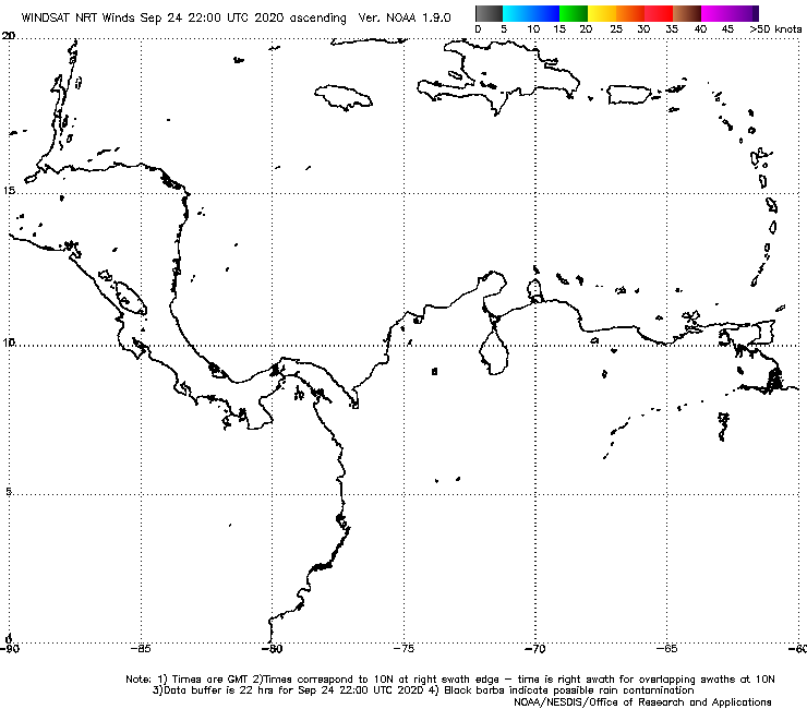
It's close on having a closed center imo.
http://manati.star.nesdis.noaa.gov/wind ... 0_noaa.png
http://manati.star.nesdis.noaa.gov/wind ... 0_noaa.png
2 likes
The posts or stuff said are NOT an official forecast. Please look to the NHC and NWS for official forecasts and products.
Floyd-1999, Frances-2004, Jeanne-2004, Fay-2008, Beryl-2012, Debby-2012, Colin-2016, Hermine-2016, Julia-2016, Matthew-2016, Irma-2017, Elsa-2021, Idalia-2023, Debby-2024, Helene-2024.
Go Gators! Go Jags!
Floyd-1999, Frances-2004, Jeanne-2004, Fay-2008, Beryl-2012, Debby-2012, Colin-2016, Hermine-2016, Julia-2016, Matthew-2016, Irma-2017, Elsa-2021, Idalia-2023, Debby-2024, Helene-2024.
Go Gators! Go Jags!

Re: ATL: INVEST 97L - Discussion
It looks like this invest is Making a jog northwest or WNW could mean cchange in track by 100 miles or so this thing isn't listening to the models it looks vigorious
0 likes
Who is online
Users browsing this forum: No registered users and 19 guests