ATL: EARL - Remnants - Discussion
Moderator: S2k Moderators

Re: ATL: INVEST 97L - Models
Wondering if we could see a significant shift north if it develops quicker than expected. Models keep it really strung out until the Western Caribbean.
0 likes

Re: ATL: INVEST 97L - Models
Some interesting intensity guidances... The majority shows it at least gaining TS strength. A few even show it becoming a Cat 3 major 

0 likes
Igor 2010, Sandy 2012, Fay 2014, Gonzalo 2014, Joaquin 2015, Nicole 2016, Humberto 2019, Imelda 2025
I am only a tropical weather enthusiast. My predictions are not official and may or may not be backed by sound meteorological data. For official information, please refer to the NHC and NWS products.
I am only a tropical weather enthusiast. My predictions are not official and may or may not be backed by sound meteorological data. For official information, please refer to the NHC and NWS products.
Re: ATL: INVEST 97L - Models
RL3AO wrote:Wondering if we could see a significant shift north if it develops quicker than expected. Models keep it really strung out until the Western Caribbean.
not likely. Maybe even a farther south track if it develops quickly. HWRF is developing this quickly and it is one of the most southern models.
Given the deep layered ridging, I don't see a stronger system moving more north in the north term
0 likes
-
tarheelprogrammer

- S2K Supporter

- Posts: 1793
- Joined: Mon Mar 28, 2016 9:25 pm
- Location: Raleigh, NC area (Garner, NC)
Re: ATL: INVEST 97L - Models
Alyono wrote:RL3AO wrote:Wondering if we could see a significant shift north if it develops quicker than expected. Models keep it really strung out until the Western Caribbean.
not likely. Maybe even a farther south track if it develops quickly. HWRF is developing this quickly and it is one of the most southern models.
Given the deep layered ridging, I don't see a stronger system moving more north in the north term
Have the models handled ridges that far out well this year?
0 likes
My posts are not official forecasts. They are just my opinion and may or may not be backed by sound meteorological data. They are NOT endorsed by any professional institution or storm2k.org. For official information, please refer to the NHC and NWS products.
-
USTropics
- Professional-Met

- Posts: 2739
- Joined: Sun Aug 12, 2007 3:45 am
- Location: Florida State University
Re: ATL: INVEST 97L - Discussion
97L coming into full view on the Guadeloupe/Martinique radar:

Link:http://www.meteofrance.gp/previsions-meteo-antilles-guyane/animation/radar/antilles
Link:http://www.meteofrance.gp/previsions-meteo-antilles-guyane/animation/radar/antilles
1 likes

Re: ATL: INVEST 97L - Models
USTropics wrote:floridasun78 wrote:USTropics wrote:This is why shear forecasts can be so difficult. Current SHIPS run below compared to a run from two days ago:Code: Select all
TIME (HR)          0     6    12    18    24    36    48    60    72    84    96   108   120
V (KT) NO LAND    30    34    38    44    48    56    63    70    77    83    92    99   105
V (KT) LAND       30    34    38    44    48    56    63    70    77    57    38    38    32
V (KT) LGEM       30    33    37    41    44    50    57    67    79    60    39    38    34
Storm Type      TROP  TROP  TROP  TROP  TROP  TROP  TROP  TROP  TROP  TROP  TROP  TROP  TROP

SHEAR (KT)         2     6     9     8     7     9     3     8     2     6     7    11     1
SHEAR ADJ (KT)    -3    -2     1     0    -1    -3     3     0     0    -2    -5    -4     1
SHEAR DIR        259   295   325   323   295   299   244   294   223   356    34    37   113
SST (C)         28.3  28.5  28.8  28.8  28.6  28.6  29.0  29.1  29.3  29.5  29.8  30.0  30.1
POT. INT. (KT)   147   149   153   153   150   149   155   156   158   160   164   169   172
ADJ. POT. INT.   162   163   166   164   158   155   159   158   156   155   156   164   166
200 MB T (C)   -53.6 -53.6 -53.5 -53.0 -53.0 -53.4 -52.6 -52.8 -52.0 -52.6 -51.9 -52.7 -52.0
200 MB VXT (C)  -0.1   0.0   0.0   0.0   0.0   0.1   0.1   0.1   0.3   0.4   0.2   0.2   0.2
TH_E DEV (C)      10    11    11    11    12    11    12    11    11     7     9     6     8
700-500 MB RH     59    59    62    62    62    64    66    68    76    78    82    83    85
MODEL VTX (KT)     7     7     9    11    10     8     7     7    10    11    12    13    13
850 MB ENV VOR    68    65    71    76    74    76    93    74    88    71    84    68    56
200 MB DIV        24    36    21    32    48    36    54    13    58    40    76    71    78
700-850 TADV       2     0     0    -2   -10    -1     0   -13    -3    -6     0    -3     6
LAND (KM)        606   498   439   248   190   124   100   253   111   -65   -47    37   -95
LAT (DEG N)     14.9  15.2  15.5  15.9  16.3  16.7  16.9  16.6  16.0  15.3  15.3  16.1  17.8
LONG(DEG W)     57.3  60.1  62.7  65.1  67.5  72.1  76.2  80.0  82.9  85.1  86.6  87.9  89.1
STM SPEED (KT)    28    26    24    23    23    21    19    17    13     9     6     9    11
HEAT CONTENT      35    47    42    66    63    90   106    56    33    71    84    34    79

  FORECAST TRACK FROM TABM      INITIAL HEADING/SPEED (DEG/KT):275/ 28      CX,CY: -27/  2
  T-12 MAX WIND:  25            PRESSURE OF STEERING LEVEL (MB):  536  (MEAN=618)
  GOES IR BRIGHTNESS TEMP. STD DEV.  50-200 KM RAD:   7.4 (MEAN=14.5)
  % GOES IR PIXELS WITH T < -20 C    50-200 KM RAD:  95.0 (MEAN=65.0)
  PRELIM RI PROB (DV .GE. 30 KT IN 24 HR):           22.4

                        INDIVIDUAL CONTRIBUTIONS TO INTENSITY CHANGE
                         6   12   18   24   36   48   60   72   84   96  108  120
                        ----------------------------------------------------------
  SAMPLE MEAN CHANGE     1.   2.   3.   4.   6.   8.   9.  11.  11.  12.  13.  13.
  SST POTENTIAL          0.   0.   0.   2.   6.  12.  18.  23.  28.  32.  36.  40.
  VERTICAL SHEAR MAG     1.   2.   3.   5.   6.   8.   9.  11.  12.  12.  11.  11.
  VERTICAL SHEAR ADJ     0.   0.   1.   1.   2.   1.   2.   2.   2.   3.   4.   3.
  VERTICAL SHEAR DIR     0.   0.  -1.  -1.  -1.  -2.  -3.  -4.  -4.  -3.  -1.   0.
  PERSISTENCE            1.   1.   2.   2.   2.   2.   1.   1.   1.   0.   0.   0.
  200/250 MB TEMP.       0.  -1.  -1.  -1.  -2.  -2.  -2.  -2.  -3.  -3.  -3.  -3.
  THETA_E EXCESS         0.   0.   0.   1.   1.   1.   1.   1.   1.   1.   1.   1.
  700-500 MB RH          0.   0.   0.   0.  -1.  -1.  -2.  -3.  -4.  -5.  -6.  -6.
  MODEL VTX TENDENCY     0.   1.   1.   1.  -1.  -3.  -3.   0.   0.   1.   2.   1.
  850 MB ENV VORTICITY   0.   0.   1.   1.   1.   2.   2.   2.   3.   3.   4.   4.
  200 MB DIVERGENCE      0.   0.   0.   0.   0.   0.   0.   0.   0.   0.   0.  -1.
  850-700 T ADVEC        0.   0.   0.   0.   0.   0.  -1.  -1.  -1.  -1.  -1.  -1.
  ZONAL STORM MOTION     0.   0.   1.   2.   4.   5.   6.   6.   7.   9.  10.  10.
  STEERING LEVEL PRES    0.   0.   0.   0.   1.   1.   1.   1.   1.   1.   1.   1.
  DAYS FROM CLIM. PEAK   0.   0.   0.   0.   0.   0.   0.   0.   1.   1.   1.   1.
  GOES PREDICTORS        1.   2.   3.   3.   3.   2.   1.   0.  -1.  -1.  -2.  -1.
  OCEAN HEAT CONTENT     0.   0.   0.   0.  -1.   0.   0.  -1.  -1.  -1.  -1.   0.
                        ----------------------------------------------------------
  TOTAL CHANGE           4.   8.  14.  18.  26.  33.  40.  47.  53.  62.  69.  75.

                CURRENT MAX WIND (KT):   30. LAT, LON:   14.9    57.3

      ** 2015 ATLANTIC RI INDEX AL972016 INVEST     07/31/16  00 UTC **
 (SHIPS-RII PREDICTOR TABLE for 30 KT OR MORE MAXIMUM WIND INCREASE IN NEXT 24-h)

     Predictor             Value   RI Predictor Range  Scaled Value(0-1) % Contribution
 12 HR PERSISTENCE (KT):     5.0     -49.5  to   33.0       0.66           8.7
 850-200 MB SHEAR (KT) :     6.6      28.8  to    2.9       0.86           5.0
 HEAT CONTENT (KJ/cm2) :    50.6       0.0  to  155.1       0.33           1.4
 STD DEV OF IR BR TEMP :     7.4      37.5  to    2.9       0.87           5.0
 2nd PC OF IR BR TEMP  :     0.6       2.8  to   -3.1       0.37           2.1
 MAXIMUM WIND (kt)     :    30.0      22.5  to  121.0       0.21           0.4
 D200 (10**7s-1)       :    32.2     -23.1  to  181.5       0.27           0.6
 POT = MPI-VMAX (KT)   :   132.4      28.4  to  139.1       0.94           3.2
 % AREA WITH TPW <45 mm:     0.0     100.0  to    0.0       1.00           1.4
 BL DRY-AIR FLUX (w/m2):   133.2     960.3  to  -67.1       0.81           0.0

 SHIPS Prob RI for 20kt/ 12hr RI threshold=   8% is   1.5 times sample mean ( 5.5%)
 SHIPS Prob RI for 25kt/ 24hr RI threshold=  43% is   3.7 times sample mean (11.6%)
 SHIPS Prob RI for 30kt/ 24hr RI threshold=  28% is   3.9 times sample mean ( 7.2%)
 SHIPS Prob RI for 35kt/ 24hr RI threshold=  13% is   3.1 times sample mean ( 4.2%)
 SHIPS Prob RI for 40kt/ 24hr RI threshold=  10% is   3.5 times sample mean ( 2.8%)
 SHIPS Prob RI for 45kt/ 36hr RI threshold=  14% is   2.9 times sample mean ( 4.9%)
 SHIPS Prob RI for 55kt/ 48hr RI threshold=  25% is   4.9 times sample mean ( 5.1%)

 Matrix of RI probabilities
 ---------------------------------------------------------------------
  RI (kt / h)  | 20/12 | 25/24 | 30/24 | 35/24 | 40/24 | 45/36 | 55/48
 ---------------------------------------------------------------------
   SHIPS-RII:     8.4%   42.7%   27.8%   12.9%    9.9%   14.4%   25.1%
    Logistic:    10.5%   44.2%   25.5%   13.7%    0.0%   28.0%   58.4%
    Bayesian:     1.4%   15.4%    4.0%    0.2%    0.2%    0.3%    2.2%
   Consensus:     6.8%   34.1%   19.1%    8.9%    3.4%   14.2%   28.6%

   ##         ANNULAR HURRICANE INDEX (AHI) AL972016 INVEST     07/31/16  00 UTC         ##
   ## STORM NOT ANNULAR, SCREENING STEP FAILED, NPASS=5 NFAIL=2                          ##
   ## AHI=  0   (AHI OF 100 IS BEST FIT TO ANN. STRUC., 1 IS MARGINAL, 0 IS NOT ANNULAR) ##

** PROBLTY OF AT LEAST 1 SCNDRY EYEWL FORMTN EVENT AL972016 INVEST     07/31/2016  00 UTC **
TIME(HR)   0-12  12-24(0-24)  24-36(0-36)  36-48(0-48)
CLIMO(%)     0      0(  0)       0(  0)       0(  0)     <-- PROB BASED ON INTENSITY ONLY
PROB(%)      0      0(  0)       0(  0)       0(  0)     PC4 UNAVAIL...MODEL SKILL DEGRADED

** DSHIPS INTENSITY FORECAST ADJUSTED RELATIVE TO ONSET OF ERC WEAKENING PHASE **
      TIME (HR)      0     6    12    18    24    36    48    60    72    84    96   108   120
>24HR AGO (DSHIPS)  30    34    38    44    48    56    63    70    77    57    38    38    32
 18HR AGO           30    29    33    39    43    51    58    65    72    52    33    33    27
 12HR AGO           30    27    26    32    36    44    51    58    65    45    26    26    20
  6HR AGO           30    24    21    20    24    32    39    46    53    33   DIS   DIS   DIS
      NOW                              CURRENT INTENSITY < 83 KT
  IN  6HR                              INTENSITY IN  6HR < 83 KT
  IN 12HR                              INTENSITY IN 12HR < 83 KT
From 2 days ago:Code: Select all
                    * ATLANTIC     SHIPS INTENSITY FORECAST          *
                    * IR SAT DATA AVAILABLE,       OHC AVAILABLE     *
                    *  INVEST      AL972016  07/29/16  18 UTC        *

TIME (HR)          0     6    12    18    24    36    48    60    72    84    96   108   120
V (KT) NO LAND    25    26    28    31    33    38    42    47    51    55    61    68    75
V (KT) LAND       25    26    28    31    33    38    42    39    41    45    51    58    40
V (KT) LGEM       25    26    27    28    29    32    33    30    32    33    35    38    31
Storm Type      TROP  TROP  TROP  TROP  TROP  TROP  TROP  TROP  TROP  TROP  TROP  TROP  TROP

SHEAR (KT)         7     5     9    13    15    23    26    20    21    18     8     5    11
SHEAR ADJ (KT)     0     1     1     0     0    -2     1    -1     0     0     3     2    -1
SHEAR DIR         26     1   312   312   308   288   294   276   263   264   259   222    91
SST (C)         26.9  26.9  27.1  27.4  27.7  28.3  28.9  28.7  29.6  29.9  29.6  29.7  30.2
POT. INT. (KT)   127   127   130   134   138   147   156   152   166   171   165   166   173
ADJ. POT. INT.   131   132   137   144   149   160   170   163   175   175   167   168   173
200 MB T (C)   -53.9 -53.9 -54.0 -54.0 -53.7 -53.7 -53.4 -53.6 -53.3 -53.0 -52.6 -52.5 -52.4
200 MB VXT (C)   0.0   0.0   0.0   0.0   0.0   0.0   0.0   0.0   0.0   0.0   0.0   0.0   0.0
TH_E DEV (C)       8     8     9     9    10    11    12    13    13    13    12     9     9
700-500 MB RH     58    58    56    54    52    51    55    60    63    63    65    74    75
MODEL VTX (KT)     0  LOST  LOST  LOST  LOST  LOST  LOST  LOST  LOST  LOST  LOST  LOST  LOST
850 MB ENV VOR    84    81    73    67    52    53    31    46    51    42    56    64    67
200 MB DIV        18    25    34    29    33     9    21    11    24     9    25    38    46
700-850 TADV      -1    -1     0     1     0    16     0    -6    -5    -9    -7    -3     0
LAND (KM)       1440  1318  1224  1163  1073   768   149   -58    88   161   223    49  -128
LAT (DEG N)     14.0  14.3  14.8  15.4  16.1  17.4  18.5  18.8  19.0  18.5  17.7  16.2  14.6
LONG(DEG W)     42.9  45.1  47.4  50.0  52.7  58.5  64.3  70.2  75.4  79.8  83.5  86.4  88.8
STM SPEED (KT)    21    22    24    26    27    29    28    27    23    19    17    15    13
HEAT CONTENT       4     5    10    23    47    31    17    69    79   116    55    16    75

  FORECAST TRACK FROM TABM      INITIAL HEADING/SPEED (DEG/KT):275/ 19      CX,CY: -18/  2
  T-12 MAX WIND:  25            PRESSURE OF STEERING LEVEL (MB):  518  (MEAN=618)
  GOES IR BRIGHTNESS TEMP. STD DEV.  50-200 KM RAD:   9.5 (MEAN=14.5)
  % GOES IR PIXELS WITH T < -20 C    50-200 KM RAD:   8.0 (MEAN=65.0)
  PRELIM RI PROB (DV .GE. 30 KT IN 24 HR):            4.1

                        INDIVIDUAL CONTRIBUTIONS TO INTENSITY CHANGE
                         6   12   18   24   36   48   60   72   84   96  108  120
                        ----------------------------------------------------------
  SAMPLE MEAN CHANGE     1.   2.   3.   4.   6.   8.   9.  11.  11.  12.  13.  13.
  SST POTENTIAL          1.   1.   1.   2.   6.  12.  19.  24.  30.  35.  40.  44.
  VERTICAL SHEAR MAG     1.   2.   3.   4.   4.   3.   0.  -2.  -4.  -5.  -4.  -3.
  VERTICAL SHEAR ADJ     0.   0.   0.   0.   1.   1.   1.   2.   2.   2.   1.   1.
  VERTICAL SHEAR DIR     0.   0.   0.   0.   0.   0.  -1.  -2.  -3.  -4.  -5.  -4.
  PERSISTENCE            0.  -1.  -1.  -1.  -1.  -1.  -1.  -1.   0.   0.   0.   0.
  200/250 MB TEMP.       0.   0.  -1.  -1.  -1.  -1.  -1.  -1.  -1.  -1.  -1.  -1.
  THETA_E EXCESS         0.   0.   0.   0.   0.   0.   1.   1.   1.   2.   1.   2.
  700-500 MB RH          0.   0.   0.   0.   0.   0.   0.  -1.  -1.  -2.  -2.  -3.
  MODEL VTX TENDENCY     0.   0.   0.  -1.  -1.  -2.  -3.  -4.  -4.  -5.  -6.  -6.
  850 MB ENV VORTICITY   0.   0.   1.   1.   1.   1.   1.   1.   2.   2.   2.   3.
  200 MB DIVERGENCE      0.   0.   0.   0.   0.   0.   0.   0.   0.   0.   0.   1.
  850-700 T ADVEC        0.   0.   0.   0.   0.   0.   0.   0.   0.  -1.  -1.   0.
  ZONAL STORM MOTION     0.   0.   1.   1.   2.   3.   3.   4.   4.   5.   6.   6.
  STEERING LEVEL PRES    0.   0.   0.   1.   1.   1.   1.   1.   1.   1.   1.   1.
  DAYS FROM CLIM. PEAK   0.   0.   0.   0.   0.   0.   0.   0.   1.   1.   1.   1.
  GOES PREDICTORS       -1.  -2.  -2.  -3.  -5.  -6.  -6.  -7.  -6.  -5.  -4.  -4.
  OCEAN HEAT CONTENT     0.   0.   0.   0.  -1.  -1.  -1.  -1.  -1.  -1.  -1.  -1.
                        ----------------------------------------------------------
  TOTAL CHANGE           1.   3.   6.   8.  13.  17.  22.  26.  30.  36.  43.  50.

                CURRENT MAX WIND (KT):   25. LAT, LON:   14.0    42.9

      ** 2015 ATLANTIC RI INDEX AL972016 INVEST     07/29/16  18 UTC **
 (SHIPS-RII PREDICTOR TABLE for 30 KT OR MORE MAXIMUM WIND INCREASE IN NEXT 24-h)

     Predictor             Value   RI Predictor Range  Scaled Value(0-1) % Contribution
 12 HR PERSISTENCE (KT):     0.0     -49.5  to   33.0       0.60           3.6
 850-200 MB SHEAR (KT) :     9.7      28.8  to    2.9       0.74           2.0
 HEAT CONTENT (KJ/cm2) :    17.8       0.0  to  155.1       0.11           0.2
 STD DEV OF IR BR TEMP :     9.5      37.5  to    2.9       0.81           2.1
 2nd PC OF IR BR TEMP  :     1.0       2.8  to   -3.1       0.30           0.8
 MAXIMUM WIND (kt)     :    25.0      22.5  to  121.0       0.07           0.1
 D200 (10**7s-1)       :    27.8     -23.1  to  181.5       0.25           0.3
 POT = MPI-VMAX (KT)   :   113.5      28.4  to  139.1       0.77           1.2
 % AREA WITH TPW <45 mm:    53.1     100.0  to    0.0       0.47           0.3
 BL DRY-AIR FLUX (w/m2):   151.2     960.3  to  -67.1       0.79           0.0

 SHIPS Prob RI for 20kt/ 12hr RI threshold=   5% is   1.0 times sample mean ( 5.5%)
 SHIPS Prob RI for 25kt/ 24hr RI threshold=  17% is   1.5 times sample mean (11.6%)
 SHIPS Prob RI for 30kt/ 24hr RI threshold=  11% is   1.5 times sample mean ( 7.2%)
 SHIPS Prob RI for 35kt/ 24hr RI threshold=   9% is   2.1 times sample mean ( 4.2%)
 SHIPS Prob RI for 40kt/ 24hr RI threshold=   0% is   0.0 times sample mean ( 2.8%)
 SHIPS Prob RI for 45kt/ 36hr RI threshold=   0% is   0.0 times sample mean ( 4.9%)
 SHIPS Prob RI for 55kt/ 48hr RI threshold=  12% is   2.3 times sample mean ( 5.1%)

 Matrix of RI probabilities
 ---------------------------------------------------------------------
  RI (kt / h)  | 20/12 | 25/24 | 30/24 | 35/24 | 40/24 | 45/36 | 55/48
 ---------------------------------------------------------------------
   SHIPS-RII:     5.5%   16.9%   10.6%    8.7%    0.0%    0.0%   11.7%
    Logistic:   999.0%  999.0%  999.0%  999.0%    0.0%  999.0%    3.1%
    Bayesian:   999.0%    2.1%    0.4%    0.0%    0.0%    0.0%    0.0%
   Consensus:   999.0%  999.0%  999.0%  999.0%    0.0%  999.0%    5.0%

   ##         ANNULAR HURRICANE INDEX (AHI) AL972016 INVEST     07/29/16  18 UTC         ##
   ## STORM NOT ANNULAR, SCREENING STEP FAILED, NPASS=5 NFAIL=2                          ##
   ## AHI=  0   (AHI OF 100 IS BEST FIT TO ANN. STRUC., 1 IS MARGINAL, 0 IS NOT ANNULAR) ##

** PROBLTY OF AT LEAST 1 SCNDRY EYEWL FORMTN EVENT AL972016 INVEST     07/29/2016  18 UTC **
TIME(HR)   0-12  12-24(0-24)  24-36(0-36)  36-48(0-48)
CLIMO(%)     0      0(  0)       0(  0)       0(  0)     <-- PROB BASED ON INTENSITY ONLY
PROB(%)      0      0(  0)       0(  0)       0(  0)     PC4 UNAVAIL...MODEL SKILL DEGRADED

** DSHIPS INTENSITY FORECAST ADJUSTED RELATIVE TO ONSET OF ERC WEAKENING PHASE **
      TIME (HR)      0     6    12    18    24    36    48    60    72    84    96   108   120
>24HR AGO (DSHIPS)  25    26    28    31    33    38    42    39    41    45    51    58    40
 18HR AGO           25    24    26    29    31    36    40    37    39    43    49    56    38
 12HR AGO           25    22    21    24    26    31    35    32    34    38    44    51    33
  6HR AGO           25    19    16    15    17    22    26    23    25    29    35    42    24
      NOW                              CURRENT INTENSITY < 83 KT
  IN  6HR                              INTENSITY IN  6HR < 83 KT
  IN 12HR                              INTENSITY IN 12HR < 83 KT
so shear going less and forecast from other day chart i not good reading this?
Correct. If the shear forecast from two days ago verified, 97L would currently be under 20+ knots of shear.
Current observed shear:

GFS and Euro for days have been showing that shear was not going to be a problem.
0 likes
-
Hurricaneman

- Category 5

- Posts: 7404
- Age: 45
- Joined: Tue Aug 31, 2004 3:24 pm
- Location: central florida
Re: ATL: INVEST 97L - Models
Based on the 0zGFS it seems to based on the 999mb into Northern Mexico it most likely is a hurricane with better resolution which also based on the GFS people of south Texas need to watch this and hopefully they don't get hurricane conditions
The posts in this forum are NOT official forecast and should not be used as such. They are just the opinion of the poster and may or may not be backed by sound meteorological data. They are NOT endorsed by any professional institution or STORM2K. For official information, please refer to products from the National Hurricane Center and National Weather Service
The posts in this forum are NOT official forecast and should not be used as such. They are just the opinion of the poster and may or may not be backed by sound meteorological data. They are NOT endorsed by any professional institution or STORM2K. For official information, please refer to products from the National Hurricane Center and National Weather Service
0 likes


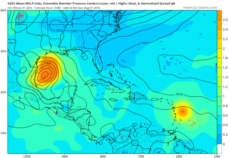
Re: ATL: INVEST 97L - Models
The 00z GFS ensemble mean is actually stronger than the operational:

0 likes
-
Rgv20

- S2K Supporter
- Posts: 2466
- Age: 39
- Joined: Wed Jan 05, 2011 5:42 pm
- Location: Edinburg/McAllen Tx
Re: ATL: INVEST 97L - Models
By day 7 the 0zGFS Operational is a bit SW of the 0zGFS Ensemble Mean with regards to 97L....it also looks like a quite a few members are a bit robust with 97L! CMC still not developing this disturbance.


0 likes
The following post is NOT an official forecast and should not be used as such. It is just the opinion of the poster and may or may not be backed by sound meteorological data. It is NOT endorsed by any professional institution including storm2k.org For Official Information please refer to the NHC and NWS products.
-
Rgv20
- S2K Supporter
- Posts: 2466
- Age: 39
- Joined: Wed Jan 05, 2011 5:42 pm
- Location: Edinburg/McAllen Tx
Re: ATL: INVEST 97L - Discussion
TROPICAL WEATHER OUTLOOK
NWS NATIONAL HURRICANE CENTER MIAMI FL
200 AM EDT SUN JUL 31 2016
For the North Atlantic...Caribbean Sea and the Gulf of Mexico:
1. A fast-moving tropical wave is nearing the Lesser Antilles. Although
showers and thunderstorms are fairly well-organized, there are
currently no signs a closed surface circulation. However, this
system has the potential for some slow development during the next
couple of days, but the best chance for tropical cyclone formation
is likely to be by the early to middle part of next week when the
wave reaches the western Caribbean Sea. This system is expected to
bring locally heavy rains and gusty winds to portions of the Lesser
Antilles, Virgin Islands, and Puerto Rico today. Shower and
thunderstorm activity should spread westward across the eastern
Caribbean Sea and Hispaniola by tonight and on Monday. Interests in
these areas should monitor the progress of this disturbance.
* Formation chance through 48 hours...medium...40 percent
* Formation chance through 5 days...high...70 percent
0 likes
The following post is NOT an official forecast and should not be used as such. It is just the opinion of the poster and may or may not be backed by sound meteorological data. It is NOT endorsed by any professional institution including storm2k.org For Official Information please refer to the NHC and NWS products.
-
Rgv20
- S2K Supporter
- Posts: 2466
- Age: 39
- Joined: Wed Jan 05, 2011 5:42 pm
- Location: Edinburg/McAllen Tx
Re: ATL: INVEST 97L - Models
0zHWRF still aggressive..
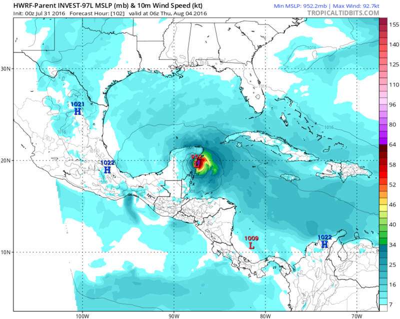
By the end of the run it has 97L in the BOC/SW Gulf..
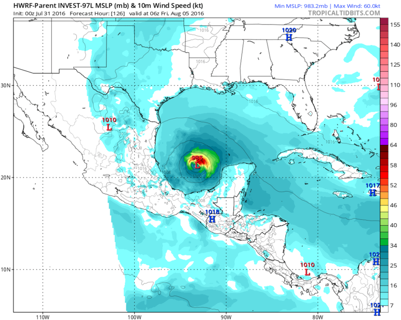

By the end of the run it has 97L in the BOC/SW Gulf..

0 likes
The following post is NOT an official forecast and should not be used as such. It is just the opinion of the poster and may or may not be backed by sound meteorological data. It is NOT endorsed by any professional institution including storm2k.org For Official Information please refer to the NHC and NWS products.
-
tarheelprogrammer
- S2K Supporter
- Posts: 1793
- Joined: Mon Mar 28, 2016 9:25 pm
- Location: Raleigh, NC area (Garner, NC)
Re: ATL: INVEST 97L - Models
ECMWF looks to initialize the storm too far north. At least I think so.
0 likes
My posts are not official forecasts. They are just my opinion and may or may not be backed by sound meteorological data. They are NOT endorsed by any professional institution or storm2k.org. For official information, please refer to the NHC and NWS products.
Re: ATL: INVEST 97L - Discussion
I think that if this can make it in the Yucatan pass between the YP and Cuba as either a strong TS or Cat. 1 I think the possibility is there for it to explode to some catastrophic if the weakness in the Ridge over Texas actually does pan out and opens up it could be a problem from anywhere from Galveston and New Orleans. If the weakness doesn't form it still might be a descent storm for Brownsville South. I think in between Brownsville and Galveston will not see the landfall. If it starts slowing down and does stay over open water and go towards the North there is I say a 70% chance of being at least a Cat 4 for a little bit if not more. If it stays south it shouldn't be any higher than Cat. 2.
0 likes
Personal Forecast Disclaimer:
The posts in this forum are NOT official forecast and should not be used as such. They are just the opinion of the poster and may or may not be backed by sound meteorological data. They are NOT endorsed by any professional institution or storm2k.org. For official information, please refer to the NHC and NWS products.
The posts in this forum are NOT official forecast and should not be used as such. They are just the opinion of the poster and may or may not be backed by sound meteorological data. They are NOT endorsed by any professional institution or storm2k.org. For official information, please refer to the NHC and NWS products.

Re: ATL: INVEST 97L - Discussion
Euro is not bringing this into the GoM, and I think Harvey in 2011 could be a good analog system.

http://199.9.2.143/tcdat/tc11/ATL/08L.HARVEY/vis/geo/1km/20110815.2015.goes13.x.vis1km.93LINVEST.25kts-1010mb-136N-592W.100pc.jpg
Wave as it passed through the Antilles.
http://199.9.2.143/tcdat/tc11/ATL/08L.HARVEY/vis/geo/1km/20110815.2015.goes13.x.vis1km.93LINVEST.25kts-1010mb-136N-592W.100pc.jpg
Wave as it passed through the Antilles.
0 likes
The above post is not official and should not be used as such. It is the opinion of the poster and may or may not be backed by sound meteorological data. It is not endorsed by any professional institution or storm2k.org. For official information, please refer to the NHC and NWS products.

Re: ATL: INVEST 97L - Discussion
Really beginning to convect and am curious if we'll begin to see some pressure falls today.
0 likes
Andy D
(For official information, please refer to the NHC and NWS products.)
(For official information, please refer to the NHC and NWS products.)
Re: ATL: INVEST 97L - Models
tarheelprogrammer wrote:ECMWF looks to initialize the storm too far north. At least I think so.
GFS pushed development back a full day over the course of a single run, and is much further south (closer to the Euro) so this is looking less likely to make it into the Gulf. Euro is likely on to something here, and the main low-level 'spin' seems to be outrunning the convection to the south and west due to the forward speed.
0 likes
The above post is not official and should not be used as such. It is the opinion of the poster and may or may not be backed by sound meteorological data. It is not endorsed by any professional institution or storm2k.org. For official information, please refer to the NHC and NWS products.
-
ninel conde
Re: ATL: INVEST 97L - Models
Euro much more realistic as the far south BOC is a favored place lately though i think it wont get that far north.
0 likes
-
cycloneye

- Admin

- Posts: 149551
- Age: 69
- Joined: Thu Oct 10, 2002 10:54 am
- Location: San Juan, Puerto Rico
Re: ATL: INVEST 97L - Discussion
0 likes
Visit the Caribbean-Central America Weather Thread where you can find at first post web cams,radars
and observations from Caribbean basin members Click Here
and observations from Caribbean basin members Click Here
-
gatorcane

- S2K Supporter
- Posts: 23708
- Age: 48
- Joined: Sun Mar 13, 2005 3:54 pm
- Location: Boca Raton, FL
Re: ATL: INVEST 97L - Models
It was the UKMET that started this southward trend in the track yesterday. The 00Z UKMET still shows this never making it into the BOC with redevelopment in the EPAC:

0 likes
-
TheStormExpert
Re: ATL: INVEST 97L - Discussion
Cannot rule out a hurricane hit on NE Mexico or S. Texas.
https://twitter.com/mjventrice/status/759709875270217728
https://twitter.com/mjventrice/status/759710319837085696
https://twitter.com/mjventrice/status/759710501958025216
https://twitter.com/mjventrice/status/759709875270217728
https://twitter.com/mjventrice/status/759710319837085696
https://twitter.com/mjventrice/status/759710501958025216
0 likes
Who is online
Users browsing this forum: No registered users and 17 guests