#189 Postby Tireman4 » Wed Jul 06, 2016 10:13 am
Broken record....ughhh
000
FXUS64 KHGX 060859
AFDHGX
Area Forecast Discussion
National Weather Service Houston/Galveston TX
310 AM CDT WED JUL 6 2016
.DISCUSSION...
Ridge City going into mid-week with above normal morning
temperatures and slightly above normal afternoon T(max) readings.
A Heat Advisory remains in effect for the coastal counties that have
consistently reached 108F or greater in previous days simply due to
those higher dew points within moisture rich gulf air.
Inland locations have not achieved heat advisory criteria so, as
this forecast has become one of persistence (with little to no
change in the synoptic) our inland counties will not be under an
advisory today. There will be a Special Weather Statement issued
that will highlight the fact that, even though we will not reach
Heat Advisory criteria in numbers, the effects of consecutive days
of lower 80 minimum temperatures and middle 90 maximum temperatures
readings will take its toll on folks working outside during the day,
those unable to cool their living/working space down to below 80 F,
the elderly, children and pets. Thus, precautions should be taken to
ensure we all stay safe and immune to heat illness.
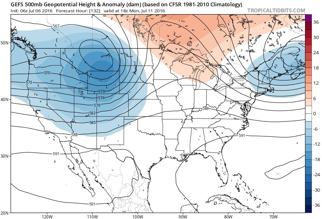
5H ridging paralleling the southern CONUS latitudes will remain in
place through the remainder of the work week. Minor
weakening/lowering heights will likely occur sometime early next
week. This will be when precipitation chances begin to creep in
from the south and east as either weak PVA enters the region
and/or a more active sea breeze provides the lift needed to bring
-TSRA potential to fruition. Ample low to mid level afternoon
lapse rates of around 7-8 C should be enough to aid in parcel
lift, but the main question mark resides in available moisture. It
seems like a joke to suggest that, after these recent weeks of >
75 F Tds, that moisture would be a problem, but model trends are
to begin advecting in a relatively drier air mass. This drier
trend will begin as early as today as current 1.7 to 1.8 inch pws
lower to around 1.5 inches with periods of slightly lower readings
in the coming days. Prog soundings do depict a fair amount of dry
air between 600-800 mb (as do recent 00Z regional soundings) so
feel this air will mix to the surface under mostly clear/sunny
skies. This will lower mid to late afternoon surface dew points
into the lower 70s. These relatively lower afternoon Tds, in
tandem with average middle 90 ambient temperatures, will equate to
heat indices in the 103 to 106 F range over the next few days. 31
&&
.MARINE...
Wind speeds are currently running 15-20 knots so will maintain the
caution flags. Otherwise...not a whole lot of change expected for
the next several days with moderate onshore flow persisting. 47
&&
.AVIATION...
Forecast of persistence remains tough to beat. Late night and morning
MVFR cigs will give way to VFR conditions during the day with moderate
southerly flow prevailing. 47
&&
.PRELIMINARY POINT TEMPS/POPS...
College Station (CLL) 97 79 98 78 97 / 10 0 10 10 10
Houston (IAH) 97 80 97 79 97 / 10 0 10 10 10
Galveston (GLS) 91 84 91 84 91 / 10 0 10 10 10
&&
.HGX WATCHES/WARNINGS/ADVISORIES...
TX...Heat Advisory from 10 AM this morning to 8 PM CDT this evening
FOR THE FOLLOWING ZONES: Brazoria...Chambers...Galveston...
Matagorda.
GM...SMALL CRAFT SHOULD EXERCISE CAUTION until 10 AM CDT this morning
FOR THE FOLLOWING ZONES: Coastal waters from Freeport to
the Matagorda Ship Channel out 20 NM...Coastal waters from
High Island to Freeport out 20 NM...Galveston Bay...
Matagorda Bay...Waters from Freeport to the Matagorda Ship
Channel from 20 to 60 NM...Waters from High Island to
Freeport from 20 to 60 NM.
&&
$$
Discussion...31/47
0 likes