Texas Summer 2016

U.S. & Caribbean Weather Discussions and Severe Weather Events

Moderator: S2k Moderators

Forum rules

The posts in this forum are NOT official forecast and should not be used as such. They are just the opinion of the poster and may or may not be backed by sound meteorological data. They are NOT endorsed by any professional institution or STORM2K.

Help Support Storm2K
Message
Author
User avatar
Ntxw
Storm2k Moderator
Storm2k Moderator
Posts: 22784
Joined: Wed Oct 21, 2009 6:34 pm
Location: DFW, Texas

Re: Texas Summer 2016

#181 Postby Ntxw » Tue Jul 05, 2016 12:03 pm

TeamPlayersBlue wrote:Great post Ntx. I got a little excited on your warm pool talk. We had great winters between 2008 - Feb 2011 which i believe were soft Nina years, and of course the warm pool of 2013 was a winter we would never forget. That combo would be nice. Will keep an eye on that now.

Also, the sunspot activity or lack thereof is something i believe we talked about in 2009 on the boards. Very interesting. JB recently made a post about it and it with his chart of the last decade, it correlated well with a cold Texas winter (low amount of sunspots.) Of course, so many other factors involved but definitely deserves some attention.


I think weak Nina/+PDO will provide plenty of cold air surges. May not mean snow but cold air availability in Canada is really good.
0 likes   
The above post and any post by Ntxw is NOT an official forecast and should not be used as such. It is just the opinion of the poster and may or may not be backed by sound meteorological data. It is NOT endorsed by any professional institution including Storm2k. For official information, please refer to NWS products.

  Help support Storm2K!
Help Support Storm2K

User avatar
Tireman4
S2K Supporter
S2K Supporter
Posts: 5853
Age: 59
Joined: Fri Jun 30, 2006 1:08 pm
Location: Humble, Texas
Contact:

Re: Texas Summer 2016

#182 Postby Tireman4 » Tue Jul 05, 2016 12:51 pm

Sorry I had a meltdown last night. I just loathe Summer so much (cue in Wxman 57 response right here...sigh). Ok, NTXW..look into your crystal ball on long range...what is August and September looking like?
1 likes   

User avatar
Kalrany
Tropical Storm
Tropical Storm
Posts: 198
Age: 47
Joined: Tue May 07, 2013 2:32 pm
Location: Newark DE

Re: Texas Summer 2016

#183 Postby Kalrany » Tue Jul 05, 2016 2:50 pm

Tireman4 wrote:Sorry I had a meltdown last night. I just loathe Summer so much (cue in Wxman 57 response right here...sigh). Ok, NTXW..look into your crystal ball on long range...what is August and September looking like?


Agreed. I feel the same .
0 likes   
TOTAL NOVICE. The following post is NOT an official forecast and should not be used as such. It is just the opinion of the poster. It is NOT endorsed by any professional institution including storm2k.org For Official Information please refer to the NHC and NWS products.
Lansing MI, Galveston TX, Madison WI, Houston TX, Newark DE

User avatar
Texas Snowman
Storm2k Moderator
Storm2k Moderator
Posts: 6179
Joined: Fri Jan 25, 2008 11:29 am
Location: Denison, Texas

Re: Texas Summer 2016

#184 Postby Texas Snowman » Tue Jul 05, 2016 4:08 pm

Portastorm wrote:
Ntxw wrote:Officially 3.2" of rain fell at DFW yesterday making it the wettest July 4th on record, well ahead of second place. Also making this one of the wettest July's in a long time. There is also a cluster of thunderstorms to the NW moving ESE this morning. If it holds together could add to that total.

Still hot, but all this activity has kept 100 in check which still officially has not hit.


Hope y'all are enjoying it. Here in the southern half of the state we have yet another consecutive day of heat advisories. Frying like bacon down here. Ground is already cracked and grass "crinkle-ly." Thankfully the lakes are full though.


Not everyone here in North Texas is enjoying the recent rainfall. Several times over the last couple of weeks, the radar has looked pretty good out to our west and northwest (including this morning). But it has always managed to fizzle or find a way to miss Denison entirely. Not a single drop of rain has fallen at my house in D-Town for some time now.

On a side note, the lightning strikes were apparently something else yesterday morning down in the DFW area. A friend of mine here in Denison, his parents live down in the Farmer's Branch area. Their home burned significantly from a lightning strike yesterday morning on the Fourth of July. They got out ok, but the home was a total loss.
0 likes   
The above post and any post by Texas Snowman is NOT an official forecast and should not be used as such. It is just the opinion of the poster and may or may not be backed by sound meteorological data. It is NOT endorsed by any professional institution including storm2k.org. For official information, please refer to NWS products.

User avatar
Ntxw
Storm2k Moderator
Storm2k Moderator
Posts: 22784
Joined: Wed Oct 21, 2009 6:34 pm
Location: DFW, Texas

Re: Texas Summer 2016

#185 Postby Ntxw » Tue Jul 05, 2016 7:42 pm

Tireman4 wrote:Sorry I had a meltdown last night. I just loathe Summer so much (cue in Wxman 57 response right here...sigh). Ok, NTXW..look into your crystal ball on long range...what is August and September looking like?


More of the same. This isn't going to be an oppressive summer, at worse near to slightly above normal. Not the endless days of 100+. July is mid of JJA so you're kind of halfway there! Just very boring so far and will continue that way. Heat ridges have been weaker than anticipated in our area, they have bulked up closer to the four corners and to our east. It's Texas, just have to deal with normal which is staying inside and running the AC all the time...

What has been high is the dewpoints. It's been a sticky summer. Result of the wet soils we've all managed to wealth up on.
1 likes   
The above post and any post by Ntxw is NOT an official forecast and should not be used as such. It is just the opinion of the poster and may or may not be backed by sound meteorological data. It is NOT endorsed by any professional institution including Storm2k. For official information, please refer to NWS products.


  Help support Storm2K!

Help Support Storm2K


User avatar
TeamPlayersBlue
Category 5
Category 5
Posts: 3445
Joined: Tue Feb 02, 2010 1:44 am
Location: Denver/Applewood, CO

Re: Texas Summer 2016

#186 Postby TeamPlayersBlue » Wed Jul 06, 2016 7:20 am

Very high dewpoints, i had a low of 81 yesterday morning. Thats ridiculous.
0 likes   
Personal Forecast Disclaimer:
The posts in this forum are NOT official forecast and should not be used as such. They are just the opinion of the poster and may or may not be backed by sound meteorological data. They are NOT endorsed by any professional institution or storm2k.org. For official information, please refer to the NHC and NWS products.

User avatar
srainhoutx
S2K Supporter
S2K Supporter
Posts: 6919
Age: 67
Joined: Sun Jan 14, 2007 11:34 am
Location: Haywood County, NC
Contact:

Re: Texas Summer 2016

#187 Postby srainhoutx » Wed Jul 06, 2016 8:07 am

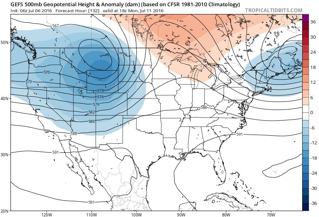
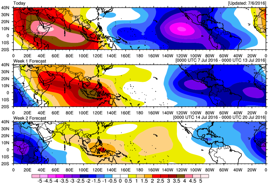
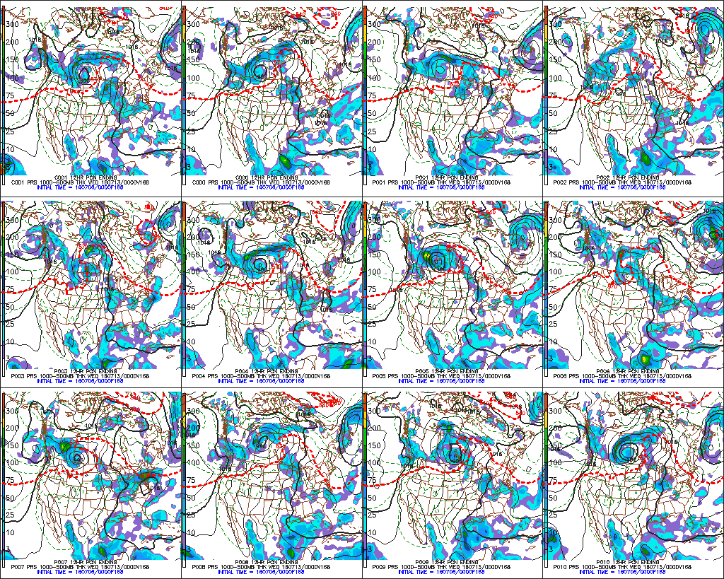
Starting to see a bit of relief from the Heat wave possible later this weekend into next week as the pattern amplifies a bit with a Western trough and possibly even some snow across the elevations of the Cascades into the Northern Rockies. The overnight guidance is suggesting a bit of African Dust arrives this weekend that may allow for some Red Skies at sunrise and sunset Saturday and Sunday. Lowering pressures begin to develop as the Upper Ridge weakens and shifts West in response to a shortwave embedded in the Western trough amplified flow. There are also some indications that a surge of deeper tropical moisture arrives in the Western Gulf early next week with increasing rain chances as the moisture surge arrives along the Eastern Mexico and Texas Gulf Coasts. This coincides with the arrival of the strong Madden Julian Oscillation Pulse that we have been monitoring the past 7 to 10 days and has played a role along with the Convectively Coupled Kelvin Wave in developing the Eastern Pacific Tropical Cyclones. So far we have not seen temperatures reach 100 degrees (actual temperature reading) across portions of N Central, SE and Eastern Texas this summer. Fingers crossed we can receive some cooling showers/storms next week.

Image

Image

Image
1 likes   
Carla/Alicia/Jerry(In The Eye)/Michelle/Charley/Ivan/Dennis/Katrina/Rita/Wilma/Ike/Harvey

Member: National Weather Association
Wx Infinity Forums
http://wxinfinity.com/index.php

Facebook.com/WeatherInfinity
Twitter @WeatherInfinity

User avatar
Tireman4
S2K Supporter
S2K Supporter
Posts: 5853
Age: 59
Joined: Fri Jun 30, 2006 1:08 pm
Location: Humble, Texas
Contact:

Re: Texas Summer 2016

#188 Postby Tireman4 » Wed Jul 06, 2016 10:11 am

Ntxw wrote:
Tireman4 wrote:Sorry I had a meltdown last night. I just loathe Summer so much (cue in Wxman 57 response right here...sigh). Ok, NTXW..look into your crystal ball on long range...what is August and September looking like?


More of the same. This isn't going to be an oppressive summer, at worse near to slightly above normal. Not the endless days of 100+. July is mid of JJA so you're kind of halfway there! Just very boring so far and will continue that way. Heat ridges have been weaker than anticipated in our area, they have bulked up closer to the four corners and to our east. It's Texas, just have to deal with normal which is staying inside and running the AC all the time...

What has been high is the dewpoints. It's been a sticky summer. Result of the wet soils we've all managed to wealth up on.


I know..is it a saving grace...ughh....I would rather...have the highest temperatures in the mid 90's with 60 degree dewpoints. Now you are talking. :)
0 likes   

User avatar
Tireman4
S2K Supporter
S2K Supporter
Posts: 5853
Age: 59
Joined: Fri Jun 30, 2006 1:08 pm
Location: Humble, Texas
Contact:

Re: Texas Summer 2016

#189 Postby Tireman4 » Wed Jul 06, 2016 10:13 am

Broken record....ughhh


000
FXUS64 KHGX 060859
AFDHGX

Area Forecast Discussion
National Weather Service Houston/Galveston TX
310 AM CDT WED JUL 6 2016

.DISCUSSION...
Ridge City going into mid-week with above normal morning
temperatures and slightly above normal afternoon T(max) readings.

A Heat Advisory remains in effect for the coastal counties that have
consistently reached 108F or greater in previous days simply due to
those higher dew points within moisture rich gulf air.
Inland locations have not achieved heat advisory criteria so, as
this forecast has become one of persistence (with little to no
change in the synoptic) our inland counties will not be under an
advisory today. There will be a Special Weather Statement issued
that will highlight the fact that, even though we will not reach
Heat Advisory criteria in numbers, the effects of consecutive days
of lower 80 minimum temperatures and middle 90 maximum temperatures
readings will take its toll on folks working outside during the day,
those unable to cool their living/working space down to below 80 F,
the elderly, children and pets. Thus, precautions should be taken to
ensure we all stay safe and immune to heat illness.

5H ridging paralleling the southern CONUS latitudes will remain in
place through the remainder of the work week. Minor
weakening/lowering heights will likely occur sometime early next
week. This will be when precipitation chances begin to creep in
from the south and east as either weak PVA enters the region
and/or a more active sea breeze provides the lift needed to bring
-TSRA potential to fruition. Ample low to mid level afternoon
lapse rates of around 7-8 C should be enough to aid in parcel
lift, but the main question mark resides in available moisture. It
seems like a joke to suggest that, after these recent weeks of >
75 F Tds, that moisture would be a problem, but model trends are
to begin advecting in a relatively drier air mass. This drier
trend will begin as early as today as current 1.7 to 1.8 inch pws
lower to around 1.5 inches with periods of slightly lower readings
in the coming days. Prog soundings do depict a fair amount of dry
air between 600-800 mb (as do recent 00Z regional soundings) so
feel this air will mix to the surface under mostly clear/sunny
skies. This will lower mid to late afternoon surface dew points
into the lower 70s. These relatively lower afternoon Tds, in
tandem with average middle 90 ambient temperatures, will equate to
heat indices in the 103 to 106 F range over the next few days. 31

&&

.MARINE...
Wind speeds are currently running 15-20 knots so will maintain the
caution flags. Otherwise...not a whole lot of change expected for
the next several days with moderate onshore flow persisting. 47

&&

.AVIATION...
Forecast of persistence remains tough to beat. Late night and morning
MVFR cigs will give way to VFR conditions during the day with moderate
southerly flow prevailing. 47

&&

.PRELIMINARY POINT TEMPS/POPS...
College Station (CLL) 97 79 98 78 97 / 10 0 10 10 10
Houston (IAH) 97 80 97 79 97 / 10 0 10 10 10
Galveston (GLS) 91 84 91 84 91 / 10 0 10 10 10

&&

.HGX WATCHES/WARNINGS/ADVISORIES...
TX...Heat Advisory from 10 AM this morning to 8 PM CDT this evening
FOR THE FOLLOWING ZONES: Brazoria...Chambers...Galveston...
Matagorda.

GM...SMALL CRAFT SHOULD EXERCISE CAUTION until 10 AM CDT this morning
FOR THE FOLLOWING ZONES: Coastal waters from Freeport to
the Matagorda Ship Channel out 20 NM...Coastal waters from
High Island to Freeport out 20 NM...Galveston Bay...
Matagorda Bay...Waters from Freeport to the Matagorda Ship
Channel from 20 to 60 NM...Waters from High Island to
Freeport from 20 to 60 NM.

&&

$$

Discussion...31/47
0 likes   

User avatar
vbhoutex
Storm2k Executive
Storm2k Executive
Posts: 29112
Age: 73
Joined: Wed Oct 09, 2002 11:31 pm
Location: Cypress, TX
Contact:

Re: Texas Summer 2016

#190 Postby vbhoutex » Wed Jul 06, 2016 8:41 pm

Broken record is right!! And unfortunately we've seen how this can perpetuate itself in the past. I am hoping for a break, but an not to hopeful at this point, at least not for the next few weeks. We should rename SE TX "FEAST OR FAMINE"!
1 likes   
Skywarn, C.E.R.T.
Please click below to donate to STORM2K to help with the expenses of keeping the site going:
Image

User avatar
Tireman4
S2K Supporter
S2K Supporter
Posts: 5853
Age: 59
Joined: Fri Jun 30, 2006 1:08 pm
Location: Humble, Texas
Contact:

Re: Texas Summer 2016

#191 Postby Tireman4 » Thu Jul 07, 2016 9:52 am

True, but the HGX NWS seems hopeful for Monday....


000
FXUS64 KHGX 070930
AFDHGX

Area Forecast Discussion
National Weather Service Houston/Galveston TX
430 AM CDT THU JUL 7 2016

.DISCUSSION...
A 595 dam upper ridge is currently anchored over central and
south Texas. Another in a string of dry and slightly abnormally
warm days where many interior ambient temperatures will reach the
middle 90s for an hour or two latter this afternoon. Ample dry air
in the middle layers will mix down under partially cloudy skies.
Morning mid to upper 70 F dew points are forecast to mix out into
the lower to middle 70s inland and this will ultimately translate
to many afternoon maximum heat indices ranging between 101 F and
105 F. There may be a few locations closer to the coast, or over
counties where thicker cloud cover doesn`t provide efficient mixing,
where maximum heat indices will be greater than 106 F for an hour
or two between 2 and 4 PM. Thus, as has been the case in recent
days over more interior counties, heat indices will not achieve or
exceed 108 F (for more than two hours), so a Heat Advisory will
not be required/issued.

Rain chances will remain very low with only widely scattered
light showers passing across the local gulf waters this morning.
Ongoing upper ridging will gradually weaken going into early next
week. Lowering heights, albeit still being relatively high at
around 590 dam, may allow a more active mesobreeze to kick in.
Weaker PVA from the west does move in Tuesday, along with
increased moisture (PWATS nearing 2 inches) that, with high
instability (e.g., around 3k CAPE, 7-8 C deg 0-3 km lapse rates,
near 90 F convective temps) will lift early through mid week
warmth-of-the-day POPS to moderate probabilities. 31

&&

.MARINE...
Moderate onshore flow will persist into early next week. Speeds may
reach caution criteria from time-to-time thru the period with seas
generally running 3-5 feet. 47

&&

.AVIATION...
Continued forecast of persistence. Areas of MVFR cigs will lift into
VFR territory in the mid to late morning hours and southerly winds
will increase in speed. Scattered MVFR decks will return 5-8Z.
Rinse/repeat tomorrow. 47

&&

.PRELIMINARY POINT TEMPS/POPS...
College Station (CLL) 97 78 96 77 96 / 10 10 10 10 10
Houston (IAH) 96 80 96 79 96 / 10 10 10 10 20
Galveston (GLS) 90 84 91 83 91 / 10 10 10 10 10

&&

.HGX WATCHES/WARNINGS/ADVISORIES...
TX...NONE.
GM...SMALL CRAFT SHOULD EXERCISE CAUTION until 11 AM CDT this morning
FOR THE FOLLOWING ZONES: Coastal waters from Freeport to
the Matagorda Ship Channel out 20 NM...Coastal waters from
High Island to Freeport out 20 NM...Matagorda Bay...Waters
from Freeport to the Matagorda Ship Channel from 20 to 60
NM...Waters from High Island to Freeport from 20 to 60 NM.

&&

$$

Discussion...31/47
0 likes   

User avatar
ColdFusion
S2K Supporter
S2K Supporter
Posts: 443
Joined: Wed Feb 13, 2008 3:46 pm
Location: Addison, TX

Re: Texas Summer 2016

#192 Postby ColdFusion » Thu Jul 07, 2016 10:33 am

.DISCUSSION...
A 595 dam upper ridge is currently anchored over central and south Texas.


No need to use such language....
2 likes   

User avatar
TeamPlayersBlue
Category 5
Category 5
Posts: 3445
Joined: Tue Feb 02, 2010 1:44 am
Location: Denver/Applewood, CO

Re: Texas Summer 2016

#193 Postby TeamPlayersBlue » Thu Jul 07, 2016 10:35 am

Well, in a week or so, i think we may be able to call the state of texas generally dry again lol. Just like that. Predictions about 10 days out showing a big heat wave for most of the lower 48.
0 likes   
Personal Forecast Disclaimer:
The posts in this forum are NOT official forecast and should not be used as such. They are just the opinion of the poster and may or may not be backed by sound meteorological data. They are NOT endorsed by any professional institution or storm2k.org. For official information, please refer to the NHC and NWS products.

weatherdude1108
Category 5
Category 5
Posts: 4228
Joined: Tue Dec 13, 2011 1:04 pm
Location: Northwest Austin/Cedar Park, TX

Re: Texas Summer 2016

#194 Postby weatherdude1108 » Thu Jul 07, 2016 4:10 pm

TeamPlayersBlue wrote:Well, in a week or so, i think we may be able to call the state of texas generally dry again lol. Just like that. Predictions about 10 days out showing a big heat wave for most of the lower 48.


Depressing. When something like this starts and gets entrenched, it takes an act of God to get rain again. The reverse is if you're flooding and have regular rains, it takes a major pattern shift to change it to dry. Feast or famine is right. :roll:
0 likes   
The preceding post is NOT an official forecast, and should not be used as such. It is only the opinion of the poster and may or may not be backed by sound meteorological data. It is NOT endorsed by any professional institution including storm2k.org. For Official Information please refer to the NHC and NWS products.

User avatar
Ntxw
Storm2k Moderator
Storm2k Moderator
Posts: 22784
Joined: Wed Oct 21, 2009 6:34 pm
Location: DFW, Texas

Re: Texas Summer 2016

#195 Postby Ntxw » Thu Jul 07, 2016 7:36 pm

I'll say it again. Summer is the most boring season in Texas, especially as a weather enthusiast. Don't matter if it's 1906 or 2011. It's going to be hot, and most of the time dry. I hate summers here cool or warm. We need fall and we need it now. i remember 2013 and 2014 when July had a period of record tying cool maxes. Even then that only lasted a few days before reality kicked back in.
0 likes   
The above post and any post by Ntxw is NOT an official forecast and should not be used as such. It is just the opinion of the poster and may or may not be backed by sound meteorological data. It is NOT endorsed by any professional institution including Storm2k. For official information, please refer to NWS products.


  Help support Storm2K!

Help Support Storm2K


User avatar
Ntxw
Storm2k Moderator
Storm2k Moderator
Posts: 22784
Joined: Wed Oct 21, 2009 6:34 pm
Location: DFW, Texas

Re: Texas Summer 2016

#196 Postby Ntxw » Thu Jul 07, 2016 7:44 pm

TeamPlayersBlue wrote:Well, in a week or so, i think we may be able to call the state of texas generally dry again lol. Just like that. Predictions about 10 days out showing a big heat wave for most of the lower 48.


Actually ensembles and Euro shows the western/central ridge getting beat down by a freak low heights over the northwest and west. Ridge centering at the east coast. Heat ridges have not delivered in strength here. Last week it looked like a heat wave, so far just mid to upper 90s with a breeze...which is not that much above normal.
0 likes   
The above post and any post by Ntxw is NOT an official forecast and should not be used as such. It is just the opinion of the poster and may or may not be backed by sound meteorological data. It is NOT endorsed by any professional institution including Storm2k. For official information, please refer to NWS products.


  Help support Storm2K!

Help Support Storm2K


User avatar
TheProfessor
Professional-Met
Professional-Met
Posts: 3506
Age: 28
Joined: Tue Dec 03, 2013 10:56 am
Location: Wichita, Kansas

Re: Texas Summer 2016

#197 Postby TheProfessor » Thu Jul 07, 2016 11:11 pm

I hope anyone who might be in or near Downtown Dallas is currently and stays safe tonight.
0 likes   
An alumnus of The Ohio State University.

Your local National Weather Service office is your best source for weather information.

User avatar
Tireman4
S2K Supporter
S2K Supporter
Posts: 5853
Age: 59
Joined: Fri Jun 30, 2006 1:08 pm
Location: Humble, Texas
Contact:

Re: Texas Summer 2016

#198 Postby Tireman4 » Fri Jul 08, 2016 3:24 pm

Yippee...97 I hate Summer. I hate it...

000
FXUS64 KHGX 081755
AFDHGX

Area Forecast Discussion
National Weather Service Houston/Galveston TX
1255 PM CDT FRI JUL 8 2016

.AVIATION...
For the 18Z TAFs, VFR conditions and southerly winds 10-12 knots
are expected to prevail through the evening for all terminals.
Showers (and an isolated embedded thunderstorm) have developed
along a boundary evident on visible satellite imagery early this
afternoon, draped just east of LBX/HOU. Have added a mention in of
VCSH through 20Z to HOU to account for this feature, but expect
most convection to remain east of the Southeast Texas terminals
this afternoon before dissipating by early evening. Similar to
this morning another round of MVFR ceilings will be possible as
southerly surface winds fall below 10 knots, but given weaker low
level flow above the surface tonight confidence was only high
enough to include mention at CLL/UTS/CXO at this time. Expect
ceilings to lift back to VFR by late morning with winds increasing
back into the 10-12 knot range.

Huffman

&&

.PREV DISCUSSION... /ISSUED /

UPDATE...
DEEPER MOISTURE POISED TO THE EAST AND JUST CLIPPING THE GALVESTON
BAY AREA THIS MORNING. A FEW SHOWERS ONGOING IN LIBERTY COUNTY AT
945 AM. TEMPERATURES THIS MORNING STARTING OFF ABOUT THE SAME AS
YESTERDAY...A LITTLE COOLER FOR CXO-UTS NORTHEASTWARD.
DEWPOINTS ARE STILL HIGH NEAR THE COAST AND WITH SSW-SW WINDS THIS
MORNING EXPECT THAT MIXING OF DRY AIR DOWN WILL BE THE NORM FOR
INLAND AREAS EVEN WITH WINDS BECOMING MORE SOUTHERLY THIS
AFTERNOON...BUT NEAR THE COAST THE HIGH DEWPOINTS WILL LINGER AND
SHOULD YIELD 107-109 HEAT INDEX READINGS FOR THE GULF COAST
COASTAL COUNTIES. WILL HOIST ANOTHER HEAT ADVISORY FOR THESE SAME
COASTAL COUNTIES. CAN`T RULE OUT NEEDING TO EXPAND IT FURTHER
INLAND THIS AFTERNOON IF DEWPOINTS DON`T MIX OUT AS EXPECTED. RAIN
CHANCES DIMINISH LATE THIS AFTERNOON AS SEABREEZE MOVES INLAND
AND RUNS INTO INCREASED CIN. HEAT ADVISORY-MINOR CHANGES TO SKY
AND DEWPOINT GRIDS OTHERWISE NO CHANGES TO THE ONGOING FORECAST.
45

DISCUSSION...

PREV DISCUSSION... /ISSUED /

DISCUSSION...
TEMPS WILL AGAIN RUN 3-5 DEGREES ABOVE NORMAL AGAIN TODAY WITH
UPPER RIDGING IN CONTROL. FCST GRIDS INDICATE 104-107 HEAT
INDICIES CAN BE ANTICIPATED. IMMEDIATE COAST MAY SEE AN HOUR OR
TWO OF 108 READINGS SOMETIME BETWEEN 11AM-3PM. SOME IF THE HIRES
SOLNS ALSO SHOW THE POTENTIAL FOR SOME REAL ISOLATED/SPOTTY
SHOWERS (SIMILAR TO WHAT`S CURRENTLY SEEN OFFSHORE) FURTHER INLAND
DURING THE DAY. BUT CONSIDER YOURSELF QUITE LUCKY IF YOU HAPPEN
TO SEE ANY.

HEIGHTS BEGIN TO SLOWLY FALL OVER THE WEEKEND AS THE UPPER RIDGE
RETREATS WEST. THIS SHOULD ALLOW US TO GRADUALLY SHAVE A FEW DEGREES
OFF TEMPS AND ALSO REINTRODUCE LOWISH DIURNALLY DRIVEN POPS BACK
INTO THE FCST. THE REGION REMAINS SITUATED IN SOMEWHAT OF A
WEAKNESS BETWEEN THE WESTERN AND SUBTROPICAL RIDGES FOR A DECENT
PORTION OF NEXT WEEK. RAIN CHANCES LOOK PRIMARILY ISOLATED IN
NATURE...MAYBE MORE SCATTERED TOWARD MIDWEEK. 47

MARINE...
A few small SHRA showing up on radar over the nearshore waters early
this morning as this mostly moderate onshore flow persists. With the
broad/flat upper ridge remaining in place these next couple of days,
moderate SE winds will also remain in place over our marine forecast
areas along with seas from 3 to 5 feet. Rain chances should be most-
ly limited to the overnight/early morning across the coastal waters.
The weakening of the upper ridge around the start of next week could
produce slightly more unsettled weather next week with Gulf moisture
deepening. 41

&&

.PRELIMINARY POINT TEMPS/POPS...
College Station (CLL) 77 96 77 96 77 / 10 10 10 10 10
Houston (IAH) 79 96 79 95 79 / 10 20 10 20 10
Galveston (GLS) 82 91 81 90 83 / 10 10 10 20 10

&&

.HGX WATCHES/WARNINGS/ADVISORIES...
TX...Heat Advisory until 7 PM CDT this evening FOR THE FOLLOWING
ZONES: Brazoria...Chambers...Galveston...Matagorda.

GM...NONE.
&&

$$

Discussion...45
Aviation/Marine...14
0 likes   

User avatar
Tireman4
S2K Supporter
S2K Supporter
Posts: 5853
Age: 59
Joined: Fri Jun 30, 2006 1:08 pm
Location: Humble, Texas
Contact:

Re: Texas Summer 2016

#199 Postby Tireman4 » Fri Jul 08, 2016 3:26 pm

Ntxw wrote:I'll say it again. Summer is the most boring season in Texas, especially as a weather enthusiast. Don't matter if it's 1906 or 2011. It's going to be hot, and most of the time dry. I hate summers here cool or warm. We need fall and we need it now. i remember 2013 and 2014 when July had a period of record tying cool maxes. Even then that only lasted a few days before reality kicked back in.


You and me both brother. I loathe it. As I get older, each Summer seems to take more out of me.
0 likes   

weatherdude1108
Category 5
Category 5
Posts: 4228
Joined: Tue Dec 13, 2011 1:04 pm
Location: Northwest Austin/Cedar Park, TX

Re: Texas Summer 2016

#200 Postby weatherdude1108 » Fri Jul 08, 2016 3:54 pm

Tireman4 wrote:
Ntxw wrote:I'll say it again. Summer is the most boring season in Texas, especially as a weather enthusiast. Don't matter if it's 1906 or 2011. It's going to be hot, and most of the time dry. I hate summers here cool or warm. We need fall and we need it now. i remember 2013 and 2014 when July had a period of record tying cool maxes. Even then that only lasted a few days before reality kicked back in.


You and me both brother. I loathe it. As I get older, each Summer seems to take more out of me.


I know! I've lived in Texas since 1976, and I still despise the Summers. :grr:
You'd think I would be used to it by now. I tolerate and accept it, but that is because I don't have a choice. Mother Nature is Mother Nature and the latitude of this area on Earth is what it is.

Texas is great and has great people and things to do, but I have dreams in being in places with four distinct seasons and fewer water supply issues. But my job and most of my family are here, and I love both. :)
1 likes   
The preceding post is NOT an official forecast, and should not be used as such. It is only the opinion of the poster and may or may not be backed by sound meteorological data. It is NOT endorsed by any professional institution including storm2k.org. For Official Information please refer to the NHC and NWS products.


Return to “USA & Caribbean Weather”

Who is online

Users browsing this forum: cajungal, utpmg and 10 guests