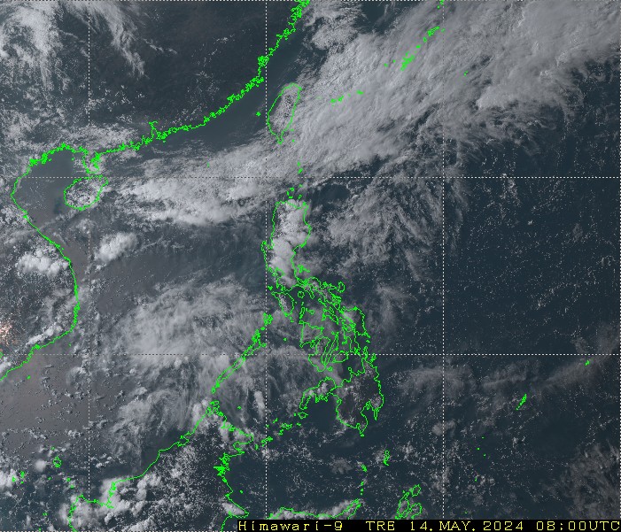
WPAC: NEPARTAK - Post-Tropical

Moderator: S2k Moderators

Message
Author
User avatar
1900hurricane
Category 5
Category 5
Posts: 6059
Age: 34
Joined: Fri Feb 06, 2015 12:04 pm
Location: Houston, TX
Contact:

Re: WPAC: NEPARTAK - Typhoon (Is a SuperTyphoon)

#221 Postby 1900hurricane » Tue Jul 05, 2016 10:58 pm

JMA upped to 115 kt (CI 7.5).

TY 1601 (Nepartak)
Issued at 03:45 UTC, 6 July 2016

<Analysis at 03 UTC, 6 July>
Scale -
Intensity Violent
Center position N19°05' (19.1°)
E129°10' (129.2°)
Direction and speed of movement WNW 35 km/h (18 kt)
Central pressure 900 hPa
Maximum wind speed near center 60 m/s (115 kt)
Maximum wind gust speed 85 m/s (165 kt)
≥ 50 kt wind area ALL 170 km (90 NM)
≥ 30 kt wind area NE 440 km (240 NM)
SW 330 km (180 NM)

<Forecast for 15 UTC, 6 July>
Intensity Violent
Center position of probability circle N20°30' (20.5°)
E126°25' (126.4°)
Direction and speed of movement WNW 30 km/h (15 kt)
Central pressure 900 hPa
Maximum wind speed near center 60 m/s (115 kt)
Maximum wind gust speed 85 m/s (165 kt)
Radius of probability circle 70 km (40 NM)
Storm warning area ALL 240 km (130 NM)

<Forecast for 03 UTC, 7 July>
Intensity Violent
Center position of probability circle N21°40' (21.7°)
E123°55' (123.9°)
Direction and speed of movement WNW 25 km/h (13 kt)
Central pressure 910 hPa
Maximum wind speed near center 55 m/s (110 kt)
Maximum wind gust speed 80 m/s (155 kt)
Radius of probability circle 110 km (60 NM)
Storm warning area ALL 280 km (150 NM)

<Forecast for 00 UTC, 8 July>
Intensity Very strong
Center position of probability circle N23°25' (23.4°)
E120°25' (120.4°)
Direction and speed of movement WNW 20 km/h (11 kt)
Central pressure 935 hPa
Maximum wind speed near center 50 m/s (95 kt)
Maximum wind gust speed 70 m/s (135 kt)
Radius of probability circle 200 km (110 NM)
Storm warning area ALL 330 km (180 NM)

<Forecast for 00 UTC, 9 July>
Intensity Strong
Center position of probability circle N25°25' (25.4°)
E118°00' (118.0°)
Direction and speed of movement NW 15 km/h (7 kt)
Central pressure 965 hPa
Maximum wind speed near center 35 m/s (70 kt)
Maximum wind gust speed 50 m/s (100 kt)
Radius of probability circle 240 km (130 NM)
Storm warning area ALL 310 km (170 NM)
0 likes   
Contract Meteorologist. TAMU & MSST. Fiercely authentic, one of a kind. We are all given free will, so choose a life meant to be lived. We are the Masters of our own Stories.
Opinions expressed are mine alone.

Follow me on Twitter at @1900hurricane : Read blogs at https://1900hurricane.wordpress.com/

stormwise

Re: WPAC: NEPARTAK - Typhoon (Is a SuperTyphoon)

#222 Postby stormwise » Tue Jul 05, 2016 11:16 pm

What bunch of storms would you group this with 1900hurricane its not imo up there with either Patricia or Haiyan.
0 likes   

User avatar
1900hurricane
Category 5
Category 5
Posts: 6059
Age: 34
Joined: Fri Feb 06, 2015 12:04 pm
Location: Houston, TX
Contact:

Re: WPAC: NEPARTAK - Typhoon (Is a SuperTyphoon)

#223 Postby 1900hurricane » Tue Jul 05, 2016 11:17 pm

Josh Morgerman is headed to Taiwan for an intercept.

 https://twitter.com/iCyclone/status/750536597628657665


1 likes   
Contract Meteorologist. TAMU & MSST. Fiercely authentic, one of a kind. We are all given free will, so choose a life meant to be lived. We are the Masters of our own Stories.
Opinions expressed are mine alone.

Follow me on Twitter at @1900hurricane : Read blogs at https://1900hurricane.wordpress.com/

User avatar
1900hurricane
Category 5
Category 5
Posts: 6059
Age: 34
Joined: Fri Feb 06, 2015 12:04 pm
Location: Houston, TX
Contact:

Re: WPAC: NEPARTAK - Typhoon (Is a SuperTyphoon)

#224 Postby 1900hurricane » Tue Jul 05, 2016 11:21 pm

stormwise wrote:What bunch of storms would you group this with 1900hurricane its not imo up there with either Patricia or Haiyan.


It's hard to rank storms without recon, but perhaps with storms like Soudelor '15, Megi '10, or Ivan '97. All were 155 kt or stronger storms in JTWC best track.
0 likes   
Contract Meteorologist. TAMU & MSST. Fiercely authentic, one of a kind. We are all given free will, so choose a life meant to be lived. We are the Masters of our own Stories.
Opinions expressed are mine alone.

Follow me on Twitter at @1900hurricane : Read blogs at https://1900hurricane.wordpress.com/

User avatar
StormChaser75
Tropical Depression
Tropical Depression
Posts: 98
Age: 23
Joined: Sat Feb 06, 2016 4:23 pm
Location: Corpus Christi TX
Contact:

Re: WPAC: NEPARTAK - Typhoon (Is a SuperTyphoon)

#225 Postby StormChaser75 » Tue Jul 05, 2016 11:25 pm

http://himawari8.nict.go.jp/himawari8-image.htm?sI=D531106&sCl=true&sClC=ffff00&sS=11&sNx=7&sNy=6&sL=-450&sT=-117&wW=1280&wH=492&sD=1467776400000
The above link shows a amazing look at typhoon nepartak and it's surroundings . :D

Image
Image

And of course some close up satellite images of the very beautiful but deadly typhoon nepartak.
0 likes   

CrazyC83
Professional-Met
Professional-Met
Posts: 34002
Joined: Tue Mar 07, 2006 11:57 pm
Location: Deep South, for the first time!

Re: WPAC: NEPARTAK - Typhoon (Is a SuperTyphoon)

#226 Postby CrazyC83 » Tue Jul 05, 2016 11:48 pm

stormwise wrote:What bunch of storms would you group this with 1900hurricane its not imo up there with either Patricia or Haiyan.


It's one notch down from them. Some comparable storms IMO:

Atlantic - Rita 2005
E Pacific - Rick 2009, Linda 1997
S Hem - Winston 2016
W Pacific - Soudelor 2005, Nida 2009, Nuri 2014
0 likes   

User avatar
mrbagyo
Category 5
Category 5
Posts: 3715
Age: 33
Joined: Thu Apr 12, 2012 9:18 am
Location: 14.13N 120.98E
Contact:

Re: WPAC: NEPARTAK - Typhoon (Is a SuperTyphoon)

#227 Postby mrbagyo » Tue Jul 05, 2016 11:55 pm

It's amazing to see this typhoon maintain its small eye fantastically clear from any low level clouds for an extended period of time...
We've been viewing the ocean through that hole for several hour already.
0 likes   
The posts in this forum are NOT official forecast and should not be used as such. They are just the opinion of the poster and may or may not be backed by sound meteorological data. They are NOT endorsed by any professional institution or storm2k.org. For official information, please refer to RSMC, NHC and NWS products.

euro6208

Re: WPAC: NEPARTAK - Typhoon (Is a SuperTyphoon)

#228 Postby euro6208 » Wed Jul 06, 2016 1:53 am

WOW!

Image
0 likes   

NotoSans
Category 5
Category 5
Posts: 1380
Age: 25
Joined: Sun Sep 27, 2015 1:15 am
Location: Toronto
Contact:

Re: WPAC: NEPARTAK - Typhoon (Is a SuperTyphoon)

#229 Postby NotoSans » Wed Jul 06, 2016 1:58 am

JTWC down to T7.0 in their latest fix.

TPPN10 PGTW 060629

A. SUPER TYPHOON 02W (NEPARTAK)

B. 06/0600Z

C. 19.46N

D. 128.47E

E. ONE/HMWRI8

F. T7.0/7.5/D2.5/24HRS STT: W0.5/03HRS

G. IR/EIR/VIS/MSI

H. REMARKS: 03A/PBO CDO EYE/ANMTN. 10NM EYE EMBEDDED APPROX 43 NM
INTO CNVCTN YIELDS AN E# AND CF (NO EYE ADJUSTMENT) OF 5.0. ADDED
2.0 FOR BANDING TO YIELD A DT OF 7.0. PT AND MET YIELD A 6.0. DBO
DT.

I. ADDITIONAL POSITIONS: NONE

HART
0 likes   
Personal Forecast Disclaimer:
The posts in this forum are NOT official forecast and should not be used as such. They are just the opinion of the poster and may or may not be backed by sound meteorological data. They are NOT endorsed by any professional institution or storm2k.org. For official information, please refer to RSMC and NWS products.

User avatar
mrbagyo
Category 5
Category 5
Posts: 3715
Age: 33
Joined: Thu Apr 12, 2012 9:18 am
Location: 14.13N 120.98E
Contact:

Re: WPAC: NEPARTAK - Typhoon (Is a SuperTyphoon)

#230 Postby mrbagyo » Wed Jul 06, 2016 2:05 am

02W NEPARTAK 160706 0600 19.5N 128.4E WPAC 150 911
0 likes   
The posts in this forum are NOT official forecast and should not be used as such. They are just the opinion of the poster and may or may not be backed by sound meteorological data. They are NOT endorsed by any professional institution or storm2k.org. For official information, please refer to RSMC, NHC and NWS products.

euro6208

Re: WPAC: NEPARTAK - Typhoon (Is a SuperTyphoon)

#231 Postby euro6208 » Wed Jul 06, 2016 2:20 am

mrbagyo wrote:02W NEPARTAK 160706 0600 19.5N 128.4E WPAC 150 911


Not surprised but still playing catchup.

It's not easy to guesstimate the intensity of this monster but at the same time, it doesn't take a professional to say this is still quite stronger.

Based on past storms and data, it's likely between 160 to 175 knots right now.
0 likes   

euro6208

Re: WPAC: NEPARTAK - Typhoon (Is a SuperTyphoon)

#232 Postby euro6208 » Wed Jul 06, 2016 2:26 am

Jeff Masters has some excellent information in his updated blog.

Super Typhoon Nepartak
0 likes   

NotoSans
Category 5
Category 5
Posts: 1380
Age: 25
Joined: Sun Sep 27, 2015 1:15 am
Location: Toronto
Contact:

Re: WPAC: NEPARTAK - Typhoon (Is a SuperTyphoon)

#233 Postby NotoSans » Wed Jul 06, 2016 2:42 am

JMA is now forecasting a sub 900 mb storm.

<Forecast for 18 UTC, 6 July>
Intensity Violent
Center position of probability circle N20°50' (20.8°)
E125°35' (125.6°)
Direction and speed of movement WNW 30 km/h (15 kt)
Central pressure 890 hPa
Maximum wind speed near center 60 m/s (120 kt)
Maximum wind gust speed 85 m/s (170 kt)
Radius of probability circle 70 km (40 NM)
Storm warning area ALL 240 km (130 NM)
0 likes   
Personal Forecast Disclaimer:
The posts in this forum are NOT official forecast and should not be used as such. They are just the opinion of the poster and may or may not be backed by sound meteorological data. They are NOT endorsed by any professional institution or storm2k.org. For official information, please refer to RSMC and NWS products.

User avatar
mrbagyo
Category 5
Category 5
Posts: 3715
Age: 33
Joined: Thu Apr 12, 2012 9:18 am
Location: 14.13N 120.98E
Contact:

Re: WPAC: NEPARTAK - Typhoon (Is a SuperTyphoon)

#234 Postby mrbagyo » Wed Jul 06, 2016 3:07 am

NotoSans wrote:JMA is now forecasting a sub 900 mb storm.

<Forecast for 18 UTC, 6 July>
Intensity Violent
Center position of probability circle N20°50' (20.8°)
E125°35' (125.6°)
Direction and speed of movement WNW 30 km/h (15 kt)
Central pressure 890 hPa
Maximum wind speed near center 60 m/s (120 kt)
Maximum wind gust speed 85 m/s (170 kt)
Radius of probability circle 70 km (40 NM)
Storm warning area ALL 240 km (130 NM)


If that forecast materialize, that would OFFICIALLY make Nepartak as the most intense tropical cyclone in terms of barometric pressure in the Western Pacific Basin since Typhoon Megi - 885 hPa (2010) --- official pressure of Haiyan was just 895 per WPAC's RSMC record


SSD is not updated once again. :cry:
0 likes   
The posts in this forum are NOT official forecast and should not be used as such. They are just the opinion of the poster and may or may not be backed by sound meteorological data. They are NOT endorsed by any professional institution or storm2k.org. For official information, please refer to RSMC, NHC and NWS products.

User avatar
StormChaser75
Tropical Depression
Tropical Depression
Posts: 98
Age: 23
Joined: Sat Feb 06, 2016 4:23 pm
Location: Corpus Christi TX
Contact:

Re: WPAC: NEPARTAK - Typhoon (Is a SuperTyphoon)

#235 Postby StormChaser75 » Wed Jul 06, 2016 3:20 am

Last few satellite images of typhoon nepartak as the sun goes down..
Image
Image
Image
Image
0 likes   

euro6208

Re: WPAC: NEPARTAK - Typhoon (Is a SuperTyphoon)

#236 Postby euro6208 » Wed Jul 06, 2016 3:25 am

Dark grey ring around eye. Looking like 170 to 180 knots with no signs of weakening.

It's a Megi Carbon from 2010 when recon found 175 knots in her.

NEPARTAK

Image

MEGI

Image


Scarily similar.... :eek:
0 likes   

User avatar
cycloneye
Admin
Admin
Posts: 145282
Age: 68
Joined: Thu Oct 10, 2002 10:54 am
Location: San Juan, Puerto Rico

Re: WPAC: NEPARTAK - Typhoon (Is a SuperTyphoon)

#237 Postby cycloneye » Wed Jul 06, 2016 5:21 am

0 likes   
Visit the Caribbean-Central America Weather Thread where you can find at first post web cams,radars
and observations from Caribbean basin members Click Here

euro6208

Re: WPAC: NEPARTAK - Typhoon (Is a SuperTyphoon)

#238 Postby euro6208 » Wed Jul 06, 2016 5:23 am

Image

WDPN31 PGTW 060900
MSGID/GENADMIN/JOINT TYPHOON WRNCEN PEARL HARBOR HI//
SUBJ/PROGNOSTIC REASONING FOR SUPER TYPHOON 02W (NEPARTAK)
WARNING NR 14//
RMKS//
1. FOR METEOROLOGISTS.
2. 6 HOUR SUMMARY AND ANALYSIS.
SUPER TYPHOON 02W (NEPARTAK), LOCATED APPROXIMATELY 509 NM
SOUTHEAST OF TAIPEI, TAIWAN, HAS TRACKED WEST-NORTHWESTWARD AT 18
KNOTS OVER THE PAST SIX HOURS. THE CURRENT POSITION IS BASED ON
RECENT SATELLITE EYE FIXES FROM PGTW AND RJTD AND A 060550Z SSMI
IMAGE, WITH HIGH CONFIDENCE. THE INTENSITY OF 150 KNOTS IS
CONSISTENT WITH SUBJECTIVE DVORAK INTENSITY ESTIMATES FROM MULTIPLE
REPORTING AGENCIES. STY 02W HAS CONTINUED TO INTENSIFY OVER THE PAST
SIX HOURS, AIDED BY LOW VERTICAL WIND SHEAR, PASSAGE OVER VERY WARM
WATER, AND VIGOROUS DUAL-CHANNEL OUTFLOW ALOFT. THE SYSTEM CONTINUES
TO TRACK QUICKLY NORTHWESTWARD ALONG THE PERIPHERY OF A DEEP-LAYERED
SUBTROPICAL STEERING RIDGE.
3. FORECAST REASONING.
A. THE FORECAST TRACK HAS SHIFTED SLIGHTLY TO THE SOUTH AND WEST
BASED ON RECENT TRENDS IN NUMERICAL MODEL TRACK FORECAST GUIDANCE
AND CURRENT ANALYSIS OF THE STEERING RIDGE ORIENTATION. FORECAST
INTENSITIES IN THE EXTENDED RANGE HAVE DECREASED TO THE DISSIPATION
THRESHOLD DUE TO AN ANTICIPATED INCREASE IN LAND INTERACTION.
B. STY 02W IS EXPECTED TO CONTINUE TRACKING GENERALLY
NORTHWESTWARD TOWARD CENTRAL TAIWAN ALONG THE PERIPHERY OF THE
CURRENT STEERING RIDGE OVER THE NEXT 48 HOURS. ENVIRONMENTAL
CONDITIONS WILL REMAIN GENERALLY FAVORABLE IN THE NEAR-TERM,
LIMITING THE POTENTIAL FOR SIGNIFICANT WEAKENING. HOWEVER, A SHIFT
IN THE UPPER-LEVEL OUTFLOW PATTERN OR UNANTICIPATED STRUCTURAL
CHANGES, SUCH AS AN EYEWALL REPLACEMENT CYCLE, COULD STILL YIELD
SOME WEAKENING PRIOR TO LANDFALL. THE SYSTEM WILL WEAKEN AS IT
CROSSES TAIWAN BETWEEN TAU 36 AND TAU 48, AND AGAIN AS IT PROGRESSES
INTO MAINLAND CHINA AFTER TAU 48. THE CIRCULATION IS EXPECTED TO
TURN POLEWARD AND MOVE FURTHER INLAND AS IT ROUNDS THE STEERING
RIDGE AXIS AFTER TAU 48. WHILE NUMERICAL MODEL GUIDANCE HAS SHIFTED
SLIGHTLY, IT IS IN GOOD OVERALL AGREEMENT IN THE NEAR-TERM, LENDING
HIGH CONFIDENCE TO THAT PORTION OF THE TRACK FORECAST.
C. IN THE EXTENDED PERIOD, STY 02W IS EXPECTED TO CONTINUE
TRACKING OVER LAND AS IT ROUNDS THE STEERING RIDGE AXIS. GIVEN THE
AMOUNT OF TIME THE SYSTEM IS NOW EXPECTED TO REMAIN OVER LAND DURING
THE FORECAST PERIOD, DISSIPATION NOW APPEARS LIKELY TO OCCUR BY TAU
120. NUMERICAL MODELS CONTINUE TO DIFFER REGARDING THE SPEED AND
TIGHTNESS OF THE POLEWARD TURN, BUT NEARLY ALL DEPICT THE
CIRCULATION REMAINING INLAND LONG ENOUGH TO DISSIPATE. GIVEN THE
NOTED MODEL SPREAD IN THE EXTENDED PERIOD, THERE IS LOW CONFIDENCE
IN THE EXTENDED FORECAST TRACK.//
NNNN
0 likes   

euro6208

Re: WPAC: NEPARTAK - Typhoon (Is a SuperTyphoon)

#239 Postby euro6208 » Wed Jul 06, 2016 6:02 am

Image

Incredible...
1 likes   

User avatar
cycloneye
Admin
Admin
Posts: 145282
Age: 68
Joined: Thu Oct 10, 2002 10:54 am
Location: San Juan, Puerto Rico

Re: WPAC: NEPARTAK - Typhoon (Is a SuperTyphoon)

#240 Postby cycloneye » Wed Jul 06, 2016 6:09 am

0 likes   
Visit the Caribbean-Central America Weather Thread where you can find at first post web cams,radars
and observations from Caribbean basin members Click Here


Return to “2016”

Who is online

Users browsing this forum: No registered users and 4 guests