ATL: COLIN - Post-Tropical - Discussion
Moderator: S2k Moderators
-
Evil Jeremy

- S2K Supporter

- Posts: 5463
- Age: 32
- Joined: Mon Apr 10, 2006 2:10 pm
- Location: Los Angeles, CA
Re: ATL: INVEST 93L - Discussion
Would a re-consolidation to the NE affect it's potential landfall location in Florida, and if so, how?
0 likes
Frances 04 / Jeanne 04 / Katrina 05 / Wilma 05 / Fay 08 / Debby 12 / Andrea 13 / Colin 16 / Hermine 16 / Matthew 16 / Irma 17
-
northjaxpro

- S2K Supporter
- Posts: 8900
- Joined: Mon Sep 27, 2010 11:21 am
- Location: Jacksonville, FL
Re: ATL: INVEST 93L - Discussion
Evil Jeremy wrote:Would a re-consolidation to the NE affect it's potential landfall location in Florida, and if so, how?
It could cause a shift a bit to the right (east )of the projected track of the center , but it would also keep the system from interacting much with land for the next 24-48 hours. Personally, I don't think the LLC is well defined at this juncture, and we won't know until Recon gets in there to be 100% certain. However, satellite presentation, ship and buoy reports could gives us indications later this evening if the LLC is reforming bit to the northeast
0 likes
NEVER, EVER SAY NEVER in the tropics and weather in general, and most importantly, with life itself!!
________________________________________________________________________________________
Fay 2008 Beryl 2012 Debby 2012 Colin 2016 Hermine 2016 Julia 2016 Matthew 2016 Irma 2017 Dorian 2019
________________________________________________________________________________________
Fay 2008 Beryl 2012 Debby 2012 Colin 2016 Hermine 2016 Julia 2016 Matthew 2016 Irma 2017 Dorian 2019

Re: ATL: INVEST 93L - Discussion
Not sure how much of a reformation this is vs the expected low finally developing there. Like Levi said in his video, that gyre off Honduras was never supposed to be the low that develops into a TC.
0 likes
-
SFLcane

- S2K Supporter
- Posts: 10281
- Age: 48
- Joined: Sat Jun 05, 2010 1:44 pm
- Location: Lake Worth Florida
Re: ATL: INVEST 93L - Discussion
I agree let's wait for recon considering things are very disorganized. May bring higher rain totals closer to South Florida. Looks to be slowly organizing though
0 likes
-
gatorcane

- S2K Supporter
- Posts: 23708
- Age: 48
- Joined: Sun Mar 13, 2005 3:54 pm
- Location: Boca Raton, FL
Re: ATL: INVEST 93L - Discussion
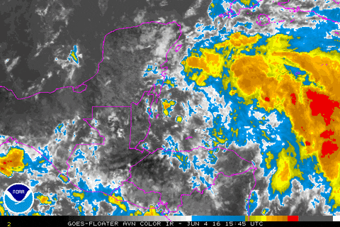
Wherever the center ends up establishing itself, you can see how large the system is with heavy rainfall and squalls extending well to the east which would put probably the entire FL peninsula under the convection when it moves northeast in the eastern Gulf
0 likes
-
gatorcane
- S2K Supporter
- Posts: 23708
- Age: 48
- Joined: Sun Mar 13, 2005 3:54 pm
- Location: Boca Raton, FL
Re: ATL: INVEST 93L - Discussion
Hmmm looks like the greatest low-level vorticity is quite a bit NE...
Also look how much more vorticity there is now than just a few hours ago.

Also look how much more vorticity there is now than just a few hours ago.
0 likes
-
northjaxpro
- S2K Supporter
- Posts: 8900
- Joined: Mon Sep 27, 2010 11:21 am
- Location: Jacksonville, FL
Re: ATL: INVEST 93L - Discussion
0 likes
NEVER, EVER SAY NEVER in the tropics and weather in general, and most importantly, with life itself!!
________________________________________________________________________________________
Fay 2008 Beryl 2012 Debby 2012 Colin 2016 Hermine 2016 Julia 2016 Matthew 2016 Irma 2017 Dorian 2019
________________________________________________________________________________________
Fay 2008 Beryl 2012 Debby 2012 Colin 2016 Hermine 2016 Julia 2016 Matthew 2016 Irma 2017 Dorian 2019
-
Yellow Evan

- Professional-Met

- Posts: 16242
- Age: 27
- Joined: Fri Jul 15, 2011 12:48 pm
- Location: Henderson, Nevada/Honolulu, HI
- Contact:
Re: ATL: INVEST 93L - Discussion
Looking better, and 93L appears to becoming better defined, with some curved band features but still a bit elongated diagonally. Not classifiable yet though.
0 likes
-
StormHunter72
- Tropical Storm

- Posts: 166
- Joined: Wed May 25, 2016 6:36 am
- Location: Nature Coast
Re: ATL: INVEST 93L - Models
Too much shear for anything to "develop" maybe a sheared tropical storm. ULL will keep it in check.
0 likes
The following post is NOT an official forecast and should not be used as such. It is just the opinion of the poster and may or may not be backed by sound meteorological data. It is NOT endorsed by any professional institution including storm2k.org For Official Information please refer to the NHC and NWS products.

Re: ATL: INVEST 93L - Discussion
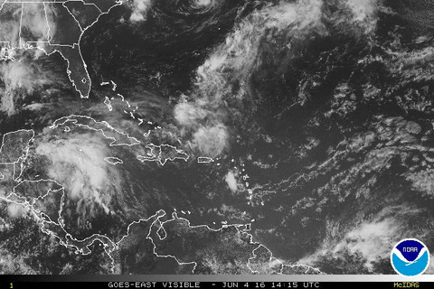
The naked eddy that is now heading inland over the Yucatan doesn't look like a dominant LLC.
There is a burst of convection ESE of the eddy which might form a LLC if the inflow environment cooperates.
The upper level low over Texas has elongated into a digging trough which may enter into the forecast later.
There is a burst of convection ESE of the eddy which might form a LLC if the inflow environment cooperates.
The upper level low over Texas has elongated into a digging trough which may enter into the forecast later.
0 likes
-
floridasun78
- Category 5

- Posts: 3755
- Joined: Sun May 17, 2009 10:16 pm
- Location: miami fl
Re: ATL: INVEST 93L - Discussion
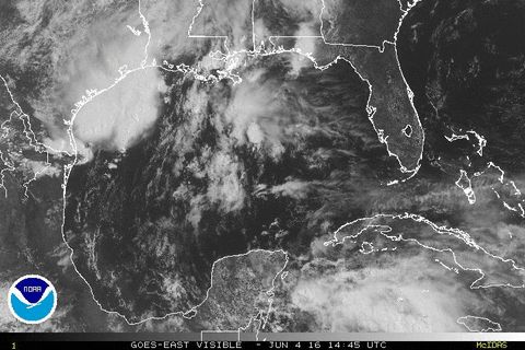
do it look were low forming more to east were nhc have it in channel between cuba and Cancun? will chance track more naple area or fort myers like earlier models show track of low?
0 likes
Re: ATL: INVEST 93L - Discussion
This image from flhurricane points out close to where I think things are slowly happening: (the rightmost arrow)

0 likes
Re: ATL: INVEST 93L - Discussion
floridasun78 wrote:do it look were low forming more to east were nhc have it in channel between cuba and Cancun? will chance track more naple area or fort myers like earlier models show track of low?
Further east there might be less shear from the digging trough in the western gulf.
Currently looks like a broad shallow low which might not organize into a named storm if there is land interaction with the Yucatan.
0 likes
-
TheStormExpert
Re: ATL: INVEST 93L - Discussion
One thing I must say is if it were not for the usual June shear I have a gut feeling 93L would have a very decent shot at obtaining hurricane strength(maybe even Cat.2).
0 likes

Re: ATL: INVEST 93L - Discussion
I have been away for the past 5 hours or so, I see a weak weak eddy rotating around just south of Cozumel, as if rotating around a larger circulation.
93L is coming together nicely, IMO.
93L is coming together nicely, IMO.
0 likes
Re: ATL: INVEST 93L - Discussion
NDG wrote:I have been away for the past 5 hours or so, I see a weak weak eddy rotating around just south of Cozumel, as if rotating around a larger circulation.
93L is coming together nicely, IMO.
If that latest convection that is blossoming stays persistent I could imagine a ridge building over the area that might fend off the shear.
Hopefully the shear will win..
0 likes
-
northjaxpro
- S2K Supporter
- Posts: 8900
- Joined: Mon Sep 27, 2010 11:21 am
- Location: Jacksonville, FL
Re: ATL: INVEST 93L - Discussion
I made mention a bit earlier as to how the outflow looks rather good on the eastern and northeast side of the developing cyclone. It sure does look like an anticyclone is trying to get somewhat established near 93L at this time.
0 likes
NEVER, EVER SAY NEVER in the tropics and weather in general, and most importantly, with life itself!!
________________________________________________________________________________________
Fay 2008 Beryl 2012 Debby 2012 Colin 2016 Hermine 2016 Julia 2016 Matthew 2016 Irma 2017 Dorian 2019
________________________________________________________________________________________
Fay 2008 Beryl 2012 Debby 2012 Colin 2016 Hermine 2016 Julia 2016 Matthew 2016 Irma 2017 Dorian 2019
-
TheStormExpert
Re: ATL: INVEST 93L - Discussion
Latest Saved Satellite Loops. Still has some work to do IMO.

0 likes

Re: ATL: INVEST 93L - Discussion
This will probably not start spinning up at the surface until it is over the Yucatan, as (for some reason) that seems to be when the low forms with these types of systems.
0 likes
The above post is not official and should not be used as such. It is the opinion of the poster and may or may not be backed by sound meteorological data. It is not endorsed by any professional institution or storm2k.org. For official information, please refer to the NHC and NWS products.
Re: ATL: INVEST 93L - Discussion
It looks a mess. But it's our mess. Notice how far to the east the impressive convection extends. the eventual center won't be the true "center" at all, but rather, a demarcation representing the western/northern extent of the active weather. After the ridiculous heat of the last couple of days I'm looking forward to ducking under 93L's cloud canopy for a bit. BTW Gale warnings are now out for the open gulf waters...Should the system achieve TS status those will change to TS warnings...but the changes to the sensible wx will effectively be non existent.
0 likes
Who is online
Users browsing this forum: No registered users and 11 guests